 Hungry
Mother State Park
Hungry
Mother State Park [Fig. 18] Walker Mountain is hardly mountain enough to divert a road as it rises gently above the valley floor north of Bristol. Its neighbor to the west, Clinch Mountain, dwarfs it. In fact, Walker all but disappears as it passes by Abingdon. But as the ridge enters Smyth County, it comes into its own, helping to define the western edge of the Great Valley as it runs northeast to the New River. North of the New River, the ridge becomes Sinking Creek Mountain. Flanking Walker on both sides are ridges with a confusing array of similar names. Don't try to apply logic to the designations. Roughly paralleling Walker across Rich Valley to the west is Little Mountain, which becomes Brushy Mountain as it progresses northeast.
East of Walker Mountain, a completely different ridge is also called first Little Brushy Mountain, then Brushy Mountain, then Little Brushy again, then Brushy, then Little Walker, and finally, beyond the break by the New River, it becomes Brush Mountain. Students of Virginia Polytechnic Institute and State University at Blacksburg know Brush Mountain well as the scenic backdrop of their campus.
Whatever the names, these mountains evoke compliments from travelers on Interstate 81. Those with time to stop find plenty of opportunities to explore Walker and its Brush/Brushy neighbor to the east. A state park, part of the Appalachian Trail, and the Wythe Ranger District of the Jefferson National Forest all make contributions. Hidden within a mountain fold north of Marion is a state park which has its own unusual name, Hungry Mother. The Appalachian Trail crosses the range about 11 miles to the north of the park and intertwines with two of the mountains' own footpaths, the Crawfish and Channel Back trails.
[Fig. 15] The Wythe Ranger District of the Jefferson National Forest contains scenic byways, dramatic overlooks, a campground, two picnic areas, hiking trails (including a 60-mile stretch of the Appalachian Trail), two wilderness areas, and a shooting range. Even so, many of the forested slopes of the Wythe's 173,400 acres have no inroads. The single campground and two picnic areas lie along the Big Walker Mountain Scenic Byway north of Wytheville.
The lack of developed areas is tantalizing to those who enjoy bushwhacking
into places where few feet have gone before. And there is always plenty to do
in nearby Mount Rogers National Recreation Area, just across the valley to the
southeast
(see Mount
Rogers National Recreation Area). However, during peak seasons, people who
enjoy a more solitary outdoors experience may find it on the limited but lesser-known
trails of the Wythe District. For help in planning an outing, stop by or call
the Wythe Ranger District office at Wytheville or the Highlands Gateway Visitor
Center at Fort Chiswell.
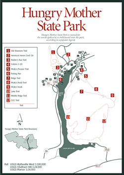
Hungry
Mother State Park [Fig. 19, Fig. 13(19), Fig. 34(1)] First, consider the legend of Hungry Mother State Park, the creek by the same name that winds through these gentle mountains, and the strenuous hiking trail with the same name that leaves the park, then threads through hemlock and hardwood to Molly's Knob.
Legends are elusive, yet the state of Virginia gives its imprimatur to the Hungry Mother story on a plaque at the park office. Legend has it that Indians attacked and wiped out several settlements along the New River south of the park as westward migration began. That part is verifiable. On one raid, Indians supposedly captured a settler named Molly Marley, along with her small child. Mother and daughter were carried off to a camp on a mountaintop north of the park. In time, Molly and child escaped. With only wild berries for food, they began the long trek out of the mountains, searching for the settlement.
Molly collapsed from exhaustion near the foot of a mountain. The child continued to wander down a small creek. When searchers found the child, the only words she could say were, "Hungry. Mother." Searchers retraced the child's steps and found Molly Marley dead where she had collapsed. Today the mountain where the Indian camp was believed to have been located is called Molly's Knob. The stream the mother and daughter followed is called Hungry Mother Creek. When the 2,180-acre park opened in 1936, a dam was built on the creek to form Hungry Mother Lake, the centerpiece of Hungry Mother State Park.
Today, the park facilities and trails hide among the Appalachian hardwoods and conifers, so that visitors' first and everlasting impression is the pristine-looking, 108-acre lake, framed by steep mountain shoreline. Inside the park office is a collection of Indian projectile points gathered from the area. This region, after all, was home to the Cherokee and the Iroquois thousands of years before European eyes ever saw its beauty.
Five log, eight frame, and seven wood-sided cabins are available for rent from March through November. Maple trees and rhododendron thickets provide sylvan privacy. If visitors prefer to camp, there are three loops with a total of 43 sites. Loop C has the only elevated wood platforms in the state park system. An oak-hickory-pine canopy provides shade. Crowding is usually not a problem. Warm summer days attract families to the swimming beach where children build sand castles while their parents sun themselves on towels. Twelve miles of trails lead away from the sounds of splashing children through oak, hickory, and tulip poplar forest cover, opening on lake views from Little Brush Mountain and Walker Mountain.
In spring, migrating and resident warblers fill the mornings with bird song in Hungry Mother State Park woodlands. Many of these birds flit among the treetops, and are more easily identified by their song than by their appearance. The black-throated blue warbler (Dendroica caerulescens), for instance, has a buzzy, rising "zwee ZWEE zwee" that the interpreter might suggest sounds like "please SQUEEZE me."
The happy, melodic song of the chestnut-sided warbler (Dendroica pensylvanica) may be easier to remember by its resemblance to "very pleased to MEETCHA!" This warbler builds its nest of grass and bark in undergrowth just a few feet off the ground, but the nesting female's secretive nature makes the nest next to impossible to find. The hooded warbler (Wilsonia citrina), northern parula (Parula americana), and black-and-white warbler (Dendroica magnolia) have also made appearances.
Fishing has improved with game- management practices, so that Hungry Mother Lake now has good largemouth bass, bluegill, crappie, muskellunge, and walleye fishing. Channel catfish of 15 to 30 pounds are hauled in occasionally. The lake has produced two state-record northern pike. Anglers familiar with the lake find the best fishing by probing the wooded coves by boat. The prohibition against gasoline-powered motors ensures a quiet outing. A state fishing license is required.
Here's an agenda that could easily fill a weekend: Check out the information center and pick up a trail brochure. Learn about the area's plants and animals on the interpretive trail. Rent a paddleboat. Take a swim. Grab a dog with the works at the snack bar. Saddle old Dusty and Duke for a placid half-hour ride on the horse trail behind the stable. Hike to Molly's Knob [Fig. 19(9)]. Dine on fried chicken and mashed potatoes at the restaurant. Sit under a starlit sky at the amphitheater as a park interpreter points out the constellations. Drift off to sleep as a gentle rain patters on your tent.
Rise before dawn for an early-morning bird walk. Watch a group of children launch leaf boats in Hungry Mother Creek. Rent a rowboat and photograph a pair of Canada geese with seven goslings bobbing between them. Thread a hook through a piece of cut bait and haul in a channel cat. Identify Christmas fern (Polystichum acrostichoides), trailing arbutus (Epigaea repens), and Indian pipe (Monotropaceae) on the Old Shawnee Trail. Flush a ruffed grouse. Close out the weekend with an evening campfire sing.
Hiking at Hungry Mother State Park. Most of the 12 miles of trails are across the lake, on the western end of Little Brushy Mountain. Two smaller trails are behind the restaurant and picnic area. All are easy to moderate, well marked, and have signs at trailheads and at junctions.
The larger network of trails on Little Brushy Mountain consists of three connected loops. Beginning near the cabins, white blazes on Molly's Knob Trail [Fig. 19(8)] lead 1.6 miles to the summit at 3,270 feet. On a clear day, Virginia's highest peak, Mount Rogers, is visible to the southwest. Hikers can return along the orange CCC Trail [Fig. 19(12)] or the yellow Middle Ridge Trail [Fig. 19(11)], or backtrack to take the Ridge Trail (gold blaze) [Fig. 19(7)]. All these are connected by the 3.1-mile Lake Trail (navy-blue blaze) [Fig. 19(10)] at the bottom.
Along the Lake Trail, the green heron might be visible. Though awkward-looking, the feeding heron slips easily on orange legs though the branches of a fallen tree, poking about in the shallows for minnows or tadpoles. A well-camouflaged dusky salamander slithers quickly out of harm's way.
On the bank above a fallen tree is a plant with long spires of white blossoms. The plant—a black cohosh (Cimicifuga racemosa)—has an unpleasant odor. The smell, which repels bugs, gives the plant its other name—bugbane. At dusk, watching from near the boat ramp, you may see a muskrat—or is it a beaver?—trailing a V behind itself as it crosses a corner of the lake. Both animals are residents at Hungry Mother.
Raider's Run Trail (royal-blue blaze) [Fig. 19(3)] is a good place to find spring wildflowers. Raiders Run Trail is a .9-mile loop that climbs gradually to the Old Shawnee Trail (green blaze) [Fig. 19(1)]. Old Shawnee is more narrow and climbs to views of Walker Mountain before descending through rhododendron and mountain laurel thickets. Combining the two trails makes a 1.8-mile loop.
Ask the park staff where visitors might find some of the flowers they've recorded. These include interesting or showy varieties such as yellow lady slipper (Cypripedium calceolus), fringed polygala—also called gaywings and bird-on-the-wing—(Polygala paucifolia), jack-in-the-pulpit (Arisaema triphyllum), wild geranium (Geranium maculatum), meadow rue (Thalictrum), and bowman's root (Gillenia trifoliata). Also, see if they'll point out the resident albino squirrel for you.
Crawfish and Channel Rock Trails. Between Marion and Wytheville on the north side of Interstate 81 is a little-known, 10-mile loop in the Wythe Ranger District of the Jefferson National Forest. The loop, marked with orange, diamond-shaped blazes, is formed by two hiking trails, the Crawfish Trail and the Channel Rock Trail [Fig. 18(12)].
The trail begins in Crawfish Valley, between Walker and Brushy mountains. After crossing Bear Creek and climbing to the top of Brushy Mountain, it follows the ridgeline along the Tennessee Valley Divide about 4 miles. The footpath then descends through Channel Rock Hollow, back into Crawfish Valley, and returns to the parking lot.
Because of the trail's remote location, with no developed recreation areas nearby, human impact is light. When walking quietly, the chances of surprising a deer, turkey, or ruffed grouse are good. There are changes in vegetation as the trail courses through open fields of wildflowers and climbs from moist, protected creek bottom to dry ridgetop. The orange-blazed loop catches the Appalachian Trail (AT) on its journey north across the Great Valley of Virginia. The AT cuts across the loop, providing two access points and opportunities for extended hikes. Local volunteers work hard to keep such trails as these clear of debris.
[Fig. 18(15)] Travelers along Interstate 81 or Interstate 77 who don't mind taking an extra half hour to get to the perfect picnic spot—one with quite a view—should turn onto the Big Walker Mountain Scenic Byway and drive to the top. The Byway passes through both public and private land on the Wythe and Bland county line north of Wytheville. The public land belongs to the Wythe Ranger District of the Jefferson National Forest, and it includes several attractions.
On the crest of Walker Mountain, at 3,405 feet, is an overlook with Rich Valley, Brush Mountain, and Garden Mountain spread out to the northwest. In the foreground is the yellow and green patchwork of farms. A tiny silo or farmhouse here and there glints in the sun. In the background is Garden Mountain, a bowl-shaped mountain with the tiny community of Burkes Garden hidden inside, and Beartown Wilderness [Fig. 18(8)] lies toward the west.
A .75-mile trail leads from the lookout parking lot to a large rock outcrop called Monster Rock, with the same view. The short trail climbs from 3,500 to 3,800 feet.
For an equally panoramic vista in the opposite direction—and for a stunning place to eat lunch—take the road across the highway from the parking lot 4 miles to Big Bend Picnic Area. At 3,950 feet, seven tables with grills and fireplaces sit under a canopy of oaks, among boulders and orchard grass. In June, rhododendrons attract butterflies and honeybees. On a clear day, Mount Rogers, Virginia's highest point (5,729 feet), is visible in the distance from the overlooks. The long, linear structure of the Ridge and Valley province is evident from both Monster Rock and Big Bend. Another picnic area, Dark Horse Hollow, is located on the banks of Stony Fork Creek off US 52, 2.3 miles south of the junction with VA 717. Stony Fork is a stocked trout stream.
Other attractions include a pleasant national forest campground, two more hiking trails, access to the Appalachian Trail, a shooting range, and several historical markers. A privately run gift shop (seasonal) at the Big Walker Mountain Overlook has a 100-foot tower to climb if the mountain's height of 3,405 feet isn't enough.
Headwaters Hunting. The view from Big Walker Mountain Overlook includes headwaters of two mighty river systems. Below, in the field of one Bland County farm, lies the beginning of the North Fork of the Holston River, headwaters of the famous Tennessee River, and Walker Creek, headwaters of the ancient New River.
Raindrops falling on that field will either drain to the south or to the north. All will eventually flow into the Gulf of Mexico. But the northbound runoff will head for West Virginia and Ohio. Water in the southbound rivulet will make it all the way to Alabama before heading back to find the Ohio in western Kentucky, where thoroughbreds graze on bluegrass.
Driving along VA 42 in the valley, this field of opposite headwaters is near the place VA 622 crosses VA 42. To get there, continue north along the US 52 byway to the junction with VA 42 and turn left. Go south about 5 miles to the junction with 622. This is the Tennessee Valley Divide, where precipitation may go either way. The actual beginning of the South Fork of the Holston is another 1.5 miles south, where VA 623 comes in from the north and two creeks converge on the east side of VA 42 (VA 623 is also the back entrance to Burkes Garden). Finding headwaters can lead you to some interesting places. A good map, a bit of curiosity, and time to hike, bike, or drive Virginia backroads are all that's necessary to get started.
 Big
Walker Mountain Scenic Byway Mile Markers: 500 yards from turn off of I-77
onto VA 717 (right)—Access road to Wythe Shooting Range.
Big
Walker Mountain Scenic Byway Mile Markers: 500 yards from turn off of I-77
onto VA 717 (right)—Access road to Wythe Shooting Range.
Mile 1.1 (on left, VA 717)—Access road to Stony Fork Creek.
Mile 1.25 (on left)—Seven Sisters Trail (east trailhead).
Mile 1.5 (on left)—Astin homesite and access to Stony Fork Creek.
Mile 3.8 (on left)—Stony Fork Campground, Stony Fork Creek, Stony Fork Nature Trail, Seven Sisters Trail.
Mile 4.3—Byway junction with US 52. Go right. (Or go left 2.3 miles to Dark Horse Hollow Picnic Area.)
Mile 7.8—Big Walker Lookout and access (on right) to Big Bend Picnic Area (4-mile drive).
Mile 12.7 (left)—Access road to Appalachian Trail.
Mile 12.8 (right)—Picnic table.
Mile 15.6—End of byway at I-77.
Stony Fork Campground [Fig. 18(13)] is located on the southern end of the Big Walker Mountain Scenic Byway, about 9 miles north of Wytheville. The 53 sites are spread under the dappled sunlight of a hardwood forest. Each site has a picnic table, fireplace, and lantern post. The East Fork of Stony Fork Creek winds through the campground, drawing children like a magnet to set leaf boats a-sail or hunt for tadpoles and salamanders.
[Fig. 18(14)] A 10-lane range next to Stony Fork Campground offers a safe place to practice target shooting and sight a gun, free of charge. The range includes target frames in six 25-yard lanes and four 100-yard lanes. Targets can be set at 7, 15, and 25 yards on the 25-yard lanes, and 7, 15, 50, and 100 yards on the 100-yard lanes.
Stony Fork Nature Trail. [Fig. 18(10)] This yellow-blazed path leads 1 mile through an oak-hickory-pine forest. An understory of rhododendron and mountain laurel blooms in early summer and stays green through winter, though temperatures below 28 degrees Fahrenheit make their leaves fold down.
Seven Sisters Trail. [Fig. 18(11)] Branching off from the Stony Fork Nature Trail, this orange-blazed, 4.8-mile trail climbs from 2,500 feet to a height of 3,300 feet on Little Walker Mountain. Hikers will notice the variation in growth as they climb from streamside vegetation and giant, old-growth pines to a dry, ridgetop oak-hickory forest.
Summer views are limited because of leaf cover, but visitors can see long distances in winter. The trail parallels the East Fork of Stony Fork Creek below as it heads northeast about 3.5 miles before descending to the creek and the parking area on VA 717, 2.5 miles east of the campground.
Tract Fork and Polecat Trails. [Fig. 20(19, 20)] Northwest of Pulaski, crossing the Wythe and Pulaski county line, is a duo of trails connecting Little Walker Mountain and Tract Mountain. Tract Fork Trail is a wide, easy, 4-mile path along Tract Fork Creek, with parking lots on both ends. Yellow, diamond-shaped blazes mark the path. Polecat Trail, marked with orange, diamond-shaped blazes, leads 1.5 miles up a Peak Creek tributary, upstream from Gatewood Reservoir.
Read and add comments about this page