 Valley
and Ridge Province I Valley
and Ridge Province I
Valley
and Ridge Province I Valley
and Ridge Province I The Valley and Ridge physiographic region of Virginia is characterized by long, narrow mountain ranges running northeast/southwest, separated by river valleys. The province lies between the Appalachian Plateau to the west and the Blue Ridge Mountains to the east. Where the sedimentary layers of rock are exposed in the Valley and Ridge, they are often tilted and folded, unlike the horizontally stacked layers of the Plateau. However, visitors to the area about 450 million years ago might not have been able to tell the difference between the two provinces.
Layers of decaying marine life of ancient oceans were deposited uniformly over the basement granites and gneisses. When the African continental plate drifted into the North American plate, geologists theorize, land to the east—closer to the point of impact—buckled, forming waves of rock called anticlines and synclines. Sometimes, a stratified layer would break—or fault—creating a thrust fault, and rise over another, leaving complex patterns of older rock on top of younger rock, and leaving geologists scratching their heads. Even after the passage of millennia, topo maps and aerial photos tell the story of long ridges suddenly curved into horseshoe shapes, or crumpled by adjacent mountains.
 To
further compound the puzzle, eroding winds and water acted on the layers at
varying speeds, wearing away softer rock on mountaintops and depositing it in
the valleys. Exposed ridges of erosion-resistant sandstone remain atop Clinch
Mountain in southwest Virginia and Massanutten Mountain in the Shenandoah Valley.
More easily erodible limestone soils settled in the valleys where they produced
fertile soils for farming. Slightly acidic water seeping through the limestone
carved an estimated 2,500 underground caverns. Today, a handful of these caverns
in the Shenandoah Valley offer guided tours. Caving groups explore the noncommercial,
or "wild" caves.
To
further compound the puzzle, eroding winds and water acted on the layers at
varying speeds, wearing away softer rock on mountaintops and depositing it in
the valleys. Exposed ridges of erosion-resistant sandstone remain atop Clinch
Mountain in southwest Virginia and Massanutten Mountain in the Shenandoah Valley.
More easily erodible limestone soils settled in the valleys where they produced
fertile soils for farming. Slightly acidic water seeping through the limestone
carved an estimated 2,500 underground caverns. Today, a handful of these caverns
in the Shenandoah Valley offer guided tours. Caving groups explore the noncommercial,
or "wild" caves.
Hikers on the trails in the Valley and Ridge may come upon fields of boulders at the base of slopes, if vegetation hasn't covered them over the years. As a result of the cooler temperatures of the last ice age, wedges of ice formed between sedimentary layers of rock. With repeated freezing and thawing, expanding and contracting, cracks formed. Finally, boulders split and tumbled from cliffs, creating boulderfields or, as geologists call them, talus slopes.
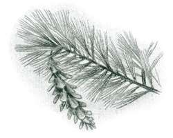
Along steep, rocky, south-facing slopes in the Valley and Ridge province are shale barrens. Often found where a meandering river has eaten into the hillside, these hostile environments support only the hardiest of plants, such as tenacious varieties of rock-cress (Arabis). (For more on shale barrens, see Johnson Creek Natural Area Preserve.) Northern hardwoods such as sugar maple (Acer saccharum), red maple, and yellow birch (Betula lutea) grow in higher elevations.
Only a few places in the Valley and Ridge of Virginia are high enough for an occasional patch of red spruce (Picea rubens), balsam fir (Abies balsamea), and other vegetation and wildlife more familiar to Canadians. Southern hardwoods, dominated by oak and hickory, forest the relatively dry lower slopes. In moist, dark hollows, lacy hemlock foliage shades rocky streams and rhododendron and wildflowers attract hikers. More open lowland streams, rivers, and wet areas are lined with sycamores, cottonwoods (Populus deltoides), silver maple (Acer saccharinum), and sweet gum (Liquidambar styraciflua).
Before early settlers hunted these forests, bison, elk, wolves, and mountain lions roamed the wilderness. Their memory lives in place names such as Elkhorn Lake, Buffalo Gap, and Wolf Creek. Now, larger wildlife include the black bear, white-tailed deer, wild turkey, and great blue heron.
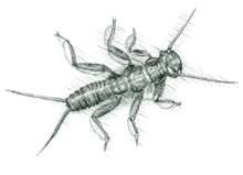
 When
larger animals are nowhere to be seen, the forests are still full of smaller
life. Crayfish hide beneath rocks in the streams. Salamanders are in damp areas
under leaves and rocks. Flying squirrels, opossums, and raccoons visit campgrounds
at night. By day, chipmunks skitter back and forth from their dens in the woods,
and groundhogs grow fat and sassy in fields and on roadsides. Where vegetation
is dense, the variety of morning birdsong can be astounding.
When
larger animals are nowhere to be seen, the forests are still full of smaller
life. Crayfish hide beneath rocks in the streams. Salamanders are in damp areas
under leaves and rocks. Flying squirrels, opossums, and raccoons visit campgrounds
at night. By day, chipmunks skitter back and forth from their dens in the woods,
and groundhogs grow fat and sassy in fields and on roadsides. Where vegetation
is dense, the variety of morning birdsong can be astounding.
Totaling 1.8 million acres, the George Washington and Jefferson National Forests occupy parts of several major mountain ranges in the Valley and Ridge province. Owned by the public, most areas of the forest are open for hiking, camping, wading, wildlife watching, wildflower identification, photography, cross-country skiing, picnicking, and seasonal hunting and fishing.
Several state parks, natural areas, and wilderness areas provide their own unique windows to the Valley and Ridge. Highways and byways offer scenic drives, including many that have never received official scenic designation. Some of the best drives are the hairline county roads on maps, or forest service roads that skirt a wilderness or snake their way back and forth up one side of a mountain and down the other.
Local people enjoy being asked how little communities got their names—places such as Lick Skillet, Silent Dell, and Cracker Neck, or streams such as Alone Mill Creek and Purgatory Creek. The possibilities for becoming acquainted with Virginia's Valley and Ridge are everywhere. The only bounds are imagination and time.
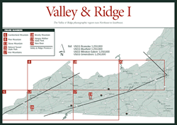
In this book, the Valley and Ridge province is divided into three sections: Valley and Ridge I, Valley and Ridge II, and Valley and Ridge III. Valley and Ridge I is the southern portion of the province, beginning in the southwest corner of the state. It extends northeastward roughly along the same course as Interstate 81. Following the natural trend of the mountains through the Blacksburg Ranger District and Havens Wildlife Management Area, it ends at Roanoke and in the western corner of Craig County.
Read and add comments about this page