 Blacksburg
Ranger District Blacksburg
Ranger District
Blacksburg
Ranger District Blacksburg
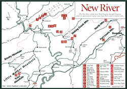
Ranger District [Fig. 15] Many who have lived in Virginia all their lives—even vacationed in the mountains—are unaware of the wealth that nature has to offer in and around the national forest west of Blacksburg. Recreation in the Jefferson National Forest here is centered in three areas. The first area, from Blacksburg heading northwest on US 460, is a long, skinny gorge between the joined-at-the-hip ridges of Brushy Mountain and Sinking Creek Mountain. The highway crosses the parallel mountains on the Eastern Continental Divide. Stocked trout streams lead away from the highway here in opposite directions.
To the left, Poverty Creek runs to the New River and ultimately the Gulf of Mexico. The upper end of this creek has been dammed to form Pandapas Pond [Fig. 20(16)]. To the right, Craig Creek leads past the Blacksburg Shooting Range [Fig. 20(18)] and the Caldwell Fields Recreation Area [Fig. 20(17)], and northeastward to the James River, the Chesapeake Bay, and the Atlantic Ocean.
After crossing these two mountains, US 460 passes the second cluster of outdoor attractions, which lies in the mountains to the north. On a jumble of mountain ridges and plateaus are two wilderness areas, a well-maintained recreation area, one of the state's most beautiful waterfalls, rock outcroppings with panoramic views, spruce bogs, stands of old-growth forests, a tremendous variety of flora and fauna, a developed campground, and a large network of trails to explore it all. In addition, cameras click when visitors discover covered bridges at Pembroke and at Newport.
The third area is in the mountains across the New River to the south, in a portion of the Walker Creek and New River watershed in southeastern Giles County. Located on the west side of Brushy Mountain's northern end are another pretty waterfall, a stocked trout stream, hiking trails, and primitive campgrounds.
Because of the variation in elevation in the Blacksburg Ranger District (1,700 to 4,200 feet), many species of plants and animals exist here. The area marks the northern boundary of many southern species and the southern limit of northern species. At the ranger district office in Blacksburg, brochures and a district map are available. The staff can answer questions and give visitors information such as where wildflowers are blooming and which unusual trees to look for. There is also a bookshelf full of excellent field guides and outdoor references. Networks of trails are available for hikers, joggers, mountain bikers, and equestrians.
Read and add comments about this page