There are over 350 miles of roads within the GSMNP, most of which extend a short way up the mountains and connect with foot trails. Persons who cannot or prefer not to hike the foot trails can use the auto tours to explore and enjoy some of the most scenic and spectacular park features. Signs along some of these routes mark Quiet Walkways, strolls of usually of less than 0.5 mile, where travelers can stop, stretch their legs, and enjoy some of the sounds and smells of the Smokies.
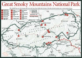
[Fig. 45] The Foothills Parkway, a two-way scenic road that was to run alongside the Great Smoky Mountains National Park, is a dream that has yet to come true. In the 1920s, the concept of providing pristine scenic views of the Smokies using a parkway was developed, and a plan approved by Congress in 1944 calls for the Foothills Parkway to run 72 miles along the park's boundary from Cosby to Chilhowee Lake, through Cocke, Sevier, and Blount counties.
Since initial construction began in 1960, only two segments of the road have been completed and opened to the public: a 5.6-mile section from Cosby to I-40 and a 17-mile section from Walland to Chilhowee Lake. A 16-mile road from Walland in Blount County to Wear Valley in Sevier County was partially completed in 1980, but environmental problems and engineering challenges brought the work on the road to a halt.
Engineers couldn't decide how to bring the two sections of the road together across Caylor Gap, a 1.6-mile length of unstable, rocky ridges and ravines. The National Park Service developed a new design that minimizes large cuts and fills in the exceedingly rugged terrain. The work will require construction of 10 bridges.
[Fig. 44(16)] The 5.5-mile Foothills Parkway-East connects I-40 with TN 32 near Cosby. Running through the foothills that overlook the lowlands between the parkway and English Mountain, is a section that looks toward the west and views of Mount Cammerer, Mount Guyot, and Greenbrier Pinnacle. The paved, two-way road is suitable for RVs and trailers and is a scenic, short approach to the northeastern edge of the GSMNP.
[Fig. 45] The 17-mile mountain drive between Townsend and Chilhowee Lake known as the Foothills Parkway-West offers scenic overlooks of the western edge of the GSMNP from the top of 2,700-foot Chilhowe Mountain. The paved, two-way road is suitable for RV and trailers and takes about 30 minutes to drive. Across the road from the scenic overlook at Look Rock, a 15-minute walk leads to a lookout tower with a panoramic view of the western edge of the Smokies to the east and the Little Tennessee River valley, once the home of the Overhill Cherokee, to the west.
[Fig. 47] Because this quiet, dead-end road is not suitable for RVs and trailers, most of the traffic you'll encounter will be hikers headed to Ramsay Cascades. The 4-mile trip to the trailhead passes the ranger station, where the pavement gives way to a good gravel road, and it passes a lovely, shady picnic shelter before reaching the sign for the road to the left to the trail to Ramsay Cascades. Ramsay Cascades is the highest waterfall accessible by trail in the GSMNP. Along this same road you can access the Old Settlers Trail as well. The Old Settlers Trail passes numerous abandoned homesteads along its 15.9-mile length. It climbs less than 500 feet as it winds its way along and across the many creeks that drain the area between Greenbrier Cove and the intersection of the Old Settlers Trail with the Maddron Bald Trail and the Gabes Mountain Trail west of Cosby Campground.
[Fig. 47] This two-lane paved road exits US 441 between Pigeon Forge and Gatlinburg and rejoins it in 4.5 miles at the northern entrance to the GSMNP and the Sugarlands Visitor Center. On this road, visitors to the GSMNP not only avoid the considerable congestion through Gatlinburg, but also as the bypass climbs the side of Mt. Harrison, it offers peaceful views of the bustling activity of Gatlinburg, with Mount Le Conte looming large and lovely in the background.
[Fig. 44(17)] Named for the 800-acre apple orchard of M.M. Whittle, this two-lane paved road allows RVs and trailers along its 3.5-mile length. Along the way, watch for wildflowers and tour the Noah "Bud" Ogle Place, a working farm from the 1800s, on a self-guiding nature trail that passes the house, barn, and tub mill. The Rainbow Falls trailhead is also on Cherokee Orchard Road. Soon after passing the Ogle farm, the road joins the one-way Roaring Fork Motor Nature Trail (see below).
[Fig. 44(5)] An intimate, one-way, 5.5-mile paved drive, the Roaring Fork Motor Nature Trail is not suitable for RVs or trailers. It begins past the Ogle Farm on Cherokee Orchard Road, and it continues to explore abandoned farmsteads and offers one of the best opportunities for viewing wildflowers in the GSMNP, including bleeding heart, solomon's seal, and the spectacular showy orchis, a member of the orchid family. A favorite activity along the curvy, steep motor loop is the short hike to Grotto Falls from the Grotto Falls parking area.
[Fig. 45] US 441, known as Newfound Gap Road in the park, travels between Gatlinburg and the northern entrance of the park at the Sugarlands Visitor Center and Cherokee, North Carolina and the southern entrance to the park at the Oconaluftee Visitor Center. The road takes its name from the gap found in the 1860s that was lower and easier to traverse than the old Indian Gap 2 miles distant. The Indian Gap was used by the old toll road until the discovery of the so-called Newfound Gap changed the course of the only road through the park. Also known as US 441, the 32-mile section allows RVs and trailers and is the most heavily traveled road in the GSMNP, requiring well over an hour to drive during peak tourist season.
From the Sugarlands Visitor Center, the road begins to slowly climb as it follows the West Prong of the Little Pigeon River on its way to the crest at Newfound Gap more than 5,000 feet above sea level. There are picnic areas, overlooks, nature trails, short walkways, stone tunnels, and an incredible 360-degree loop in the road on the way to the southern entrance to the GSMNP at Oconaluftee.
Newfound Gap Road travels between Mount Le Conte and Clingmans Dome and provides access to Clingmans Dome Road. Trailheads for several trails, including Alum Cave Trail and Chimney Tops Trail are located along Newfound Gap Road, and the Appalachian Trail crosses the road at the gap.
[Fig. 47] Clingmans Dome is the highest peak in the park at 6,643 feet. A 7-mile automobile spur road from Newfound Gap Road (US 441) winds up the side of the mountain to a parking lot. A 0.5-mile paved path leads to a concrete ramp topped by a large lookout tower with incredible views on clear fall mornings. The road is RV and trailer accessible. When the road is closed in winter, it's a favored destination after fresh snowfalls for cross-country skiers, as long as Newfound Gap Road remains open.
[Fig. 45] Scenic TN 73, more commonly known as the Little River Road, travels 18 miles between the Sugarlands Visitor Center at the northern entrance to the park and Townsend. RVs and trailers also follow this winding, predominantly lower elevation road over portions of the old Little River Railroad bed.
From Sugarlands, the road climbs to Fighting Creek Gap where parking areas on both sides of the road are provided for those hiking the easy, 2.5-mile round trip to Laurel Falls. This hike is so popular the trail has been paved as far as the falls.
A bit farther along the road, the Elkmont Campground is open through November. The remains of the old Wonderland Hotel, a nature trail, and several hiking trails are located at Elkmont, the site of extensive logging operations before the park was formed.
There's a picnic area farther west at Metcalf Bottoms with a trail leading a little over 0.5 mile to the Little Greenbrier Schoolhouse, which was built by the surrounding community members in 1882 and was used to educate the children of the area until 1936 as the weather and funding would allow. From the school continue along a one-lane gravel road that originates on Wear Cove Gap Road and travels to the Walker Sisters Farmstead, an 1870s cabin that was the home of five maiden sisters until the last surviving sister died in 1964.
Continuing on Little River Road, you'll see a small parking area at The Sinks, a tumultuous cascade into a deep sinkhole created by loggers dynamiting to break up a log jam around the turn of the century. Keep a sharp eye out for Meigs Falls, which can be seen alongside the road where Meigs Creek empties into the Little River.
Before reaching Townsend, the Little River Road intersects Laurel Creek Road, the entrance to Cades Cove, at a scenic swimming hole known as the Y. The parking area next to the Y is frequently filled with people going to splash about in the clear, cold river, sunbathe on the big flat rocks, or hike the Chestnut Top Trail.
The Chestnut Top Trail is an outstanding wildflower trail, especially in April and May when star chickweed, spring beauty, bloodroot (Sanguinaria canadensis), bishop's cap (Mitella diphylla), purple phacelia (Phacelia bipinnatifida), and sweet white trillium (Trillium simile) are in bloom along the first 0.5 mile of the 4.3-mile trek.
[Fig. 45] This is the only paved, two-way road suitable for RVs and trailers entering Cades Cove. As you begin the 7-mile, 15-minute drive, you'll see the turn-off to Tremont, a former Job Corps Camp that is now operated as a year-round environmental education center by the Great Smoky Mountains Natural History Association. Several hiking trails crisscross the road as it approaches the Cades Cove Loop Road.
[Fig. 45 ] This 11-mile, one-way, paved road tours the most popular attraction in the most popular national park in the United States. There is the potential for traffic jams that could extend the usual one-hour driving time. That being said, it's still a beautiful drive with lots of interesting attractions.
Pioneer cabins, farmsteads, and barns and historic buildings dot the slopes ringing the cove. In addition to the campground, picnic area, and riding stable, the Cades Cove Visitor Center has exhibits, a bookstore, and information about the many hiking trails in the area, including the popular walk to Abrams Falls.
The drive is open from dawn to dusk and is suitable for RVs and trailers, but bicyclists have it to themselves early mornings on Wednesday and Saturday from spring through mid-September.
[Fig. 45] This is one of two roads leading out of Cades Cove, except during winter when it's closed. This historic road was the route taken by early settlers in the cove. Today it is 7 miles one-way, steep, and curved until it crests at the park boundary at Rich Mountain Gap and is not suitable for RVs or trailers. It offers a great respite from the fall leaf-lookers creeping along the Cades Cove Loop Road and takes about one hour to drive. There is an excellent view of Cades Cove at a clearing on the side of the mountain, and there are views of Tuckaleechee Cove as you descend toward Townsend.
[Fig. 45] This is the other historic road leading out of Cades Cove and it, too, is closed in winter and is not suitable for RVs and trailers. The 8-mile gravel road is one-way, steep, and curved, traveling through lush woodlands accented by cascading mountain streams. It once connected settlers in the cove with a toll road that followed the present route of US 129. The trailhead of the Gregory Bald Trail is on Parson Branch Road.
Since Parson Branch Road exits on US 129 near Calderwood Lake southwest of the terminus of the Foothills Parkway-West, visitors can create a nice extended driving tour by taking a right turn on US 129, travelling about 10 miles to the Foothills Parkway, following the Parkway 17 miles to its terminus near Townsend, and returning to Cades Cove via the Laurel Creek Road.
[Fig. 45] The 27-mile Big Creek/Cataloochee Road follows the eastern edge of the GSMNP as it starts out as TN 32 west of Cosby. The pavement ends and the real trek begins about 11 miles later at the North Carolina line near the crossing of the Appalachian Trail at Davenport Gap.
The gravel road, now known as Old NC 284, is not suitable for RVs or trailers. It continues to the Mount Sterling Community where a left fork travels a couple of miles to I-40 via Waterville Road at Exit 451, and a right fork leads to the Big Creek Ranger Station and Campground.
Old NC 284 sticks to the center and journeys 14 miles along a very curvy, one-lane road with two-way traffic that will take a couple of hours to negotiate as you travel through one of the most remote sections of the Smokies accessible by car.
Along the way, you'll pass the trailhead for the Mount Sterling Trail, a 2.8-mile trail that climbs nearly 2,000 feet from where Old NC 284 passes through Mount Sterling Gap to the summit at Mount Sterling. From the 60-foot steel fire tower on the summit, there are beautiful views of surrounding peaks as well as Cataloochee Valley to the south. A backcountry campsite (Number 38) has several sites among the Fraser fir.
The road continues past the community once known as Little Cataloochee, a smaller settlement of families related to the earlier settlers in the larger, neighboring community of Cataloochee. A gated road open to hikers and horseback riders bears to the right into Little Cataloochee with its few remaining historic structures and apple orchards that were once the source of commerce for the community.
Another couple of miles brings you to another split in the road. Bear to the left to return to I-40 at Exit 20, about 8 miles distant via Cove Creek Road. The right fork of the road continues to the long, narrow cove of the Cataloochee Valley.
The entrance to Cataloochee Valley from US 276 is an 8-mile drive with paved and graveled sections. Travelers, including those in RVs and trailers, willing to face the challenge take Exit 20 off I-40 to US 276. Cove Creek Road, also known as Old NC 284, continues to Cove Creek Gap and bears to the right becoming a gravel surface, while Cataloochee Road begins at the left fork and descends into this once thriving community of 1,200 surrounded by peaks of the Smokies. Cataloochee Road continues as a paved road to the ranger station and campground, but becomes gravel as it passes the few remaining structures in the Cataloochee Historic District including a church, a school, houses, and barns. A auto tour guide is available at a roadside dispenser as you enter Cataloochee or from one of the GSMNP visitor centers. Cataloochee has one of the drive-in horse camps in the GSMNP.
[Fig. 45] The Blue Ridge Parkway (BRP) was proposed in 1933 to link Virginia's Shenandoah National Park and the Great Smoky Mountains National Park. Initial funding for the 469-mile scenic parkway was approved in 1933 and surveyors were in the field the next year. The initial construction began during the summer of 1935 on a 12-mile section near the Virginia/North Carolina border. Ribbon-cutting ceremonies for the completion took place 52 years later following the construction of the last link, an engineering marvel known as the Linn Cove Viaduct that curves around Grandfather Mountain in North Carolina, minimizing the parkway's effect on the environment.
The southern terminus of the 469-mile BRP is at the southern edge of the GSMNP at the junction with US 441. On the BRP, the speed limit is 45 mph, unless otherwise posted, and the paved, two-way road is suitable for RVs and trailers to share with cyclists and motorists intent on enjoying the breathtaking scenery. Allowing for stops along the way, it will take you a minimum of three to four days to feel like you've had a chance to experience a sampling of all the BRP has to offer.
As you enter the BRP on the Oconaluftee River Bridge at an elevation of 2,000 feet, you immediately begin to climb, attaining an elevation of 5,000 feet within the first 10 miles. At Richland Balsam (mile marker 431.4) you'll reach the highest point on the BRP, an elevation of 6,053 feet. In addition to scenic overlooks and picnic areas, the BRP offers self-guiding nature trails, parks, and museums.
[Fig. 48] This 9-mile, paved, high mountain road begins as a spur of the Blue Ridge Parkway near Wolf Laurel Gap (mile marker 458.2). It leads drivers along the crest of Balsam Mountain with scenic overlooks on both sides. One highlight is the Mile-High Overlook that scans the distant peaks of the Smokies to the left, including Clingmans Dome, Mount Le Conte, Mount Kephart, and Mount Guyot. To the right, the Balsam Mountains reach to the sky. After 3.3 miles, you re-enter the GSMNP. Picnic tables are available at Black Camp Gap. RVs and trailers are allowed on Balsam Mountain Road, which leads another 6 miles to Balsam Mountain Campground. At 5,310 feet, this is the highest camp accessible by road in the GSMNP. Proceed past the campground to the Heintooga Overlook with its scenic view of the Smokies. The Balsam Mountain Road is closed in winter.
[Fig. 45] The Heintooga Overlook, at the end of Balsam Mountain Road near the Balsam Mountain Campground, offers sweeping vistas of the high ranges of the Smokies. Just beyond the parking area for Heintooga Overlook, the 14-mile, one-way, gravel Heintooga-Round Bottom Road begins its curving route from an altitude of 5,535 feet to about 2,000 feet. This rough road is not suitable for RVs and trailers and is closed in winter. It will take about an hour to travel this route, which showcases the botanical diversity of the GSMNP through stands of beech and birch, followed by hemlocks, maples, and oaks. At the broad, flat area known as Round Bottom, the one-lane road becomes two-way before it joins the paved, two-way Big Cove Road north of Cherokee, North Carolina. Round Bottom has one of the drive-in horse camps in the GSMNP.
[Fig. 45] A dead-end road, Lakeview Drive travels 6 miles along the upper end of beautiful Fontana Lake. This lightly traveled road allows RVs and trailers and features scenic overlooks as well as good opportunities for fall foliage viewing. It was built in 1959 with the intention of replacing a North Carolina state road north of the lake that was flooded when Fontana Lake was created in 1944. Lakeview Drive was not completed for a variety of reasons, not the least of which was the desire to protect the roadless wild area at the southwestern end of the park.