 Ellicott
Rock Wilderness Ellicott
Rock Wilderness
Ellicott
Rock Wilderness Ellicott
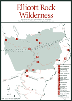
Rock Wilderness [Fig. 32(25), Fig. 35] The Ellicott Rock Wilderness encompasses one of the Southeast's premiere river gorges and includes national forests from three different states—North Carolina, South Carolina, and Georgia. It also harbors one of the oldest trails in the East and a wonderful variety of plants and animals.
The Ellicott Rock Wilderness straddles the 15,000-acre Chattooga Wild and Scenic River corridor known for its high rocky cliffs, powerful cascades, and luxuriant mixed evergreen-deciduous forests. The area contains old-growth white pine, hemlock, tulip poplar, and other hardwood specimens. Thick, impassable tangles of great rhododendron understory form over creeks and on slopes, giving the colloquial term "rhododendron hell" true meaning. At times, these shrubs form a tunnel over the well-maintained trails.
For those interested in day hiking or primitive camping, the area offers excellent trails free of motorized vehicles, horses, and bicycles, making it as much of a true wilderness experience as possible. Campsites must be located at least 50 feet from water courses or designated trails.
The Ellicott Rock Wilderness was expanded from a much smaller scenic area first created in 1966. This 1975 expansion brought the area under the protection of the 1960 Wilderness Protection Act and increased the area to 9,012 acres. Nearly half (3,900 acres) of the tract lies in North Carolina. The Chattooga River was given Wild and Scenic River status in May 1974. Since then, the U.S. Forest Service has proposed acquiring an additional 2,000 acres to the south and east of the present boundaries.
The area is reached from North Carolina via the Ellicott Rock Trail or the Bad Creek/Fowler Creek Trail [Fig. 35(3)], the latter joining with the former just before crossing into South Carolina. The trail and wilderness area get their name from a rock on the east bank of the Chattooga River that was inscribed with the letters "NC" by a surveyor named Ellicott. Ellicott Rock was marked erroneously as the point at which the three states of North Carolina, South Carolina, and Georgia meet. The correct intersection is at Commissioner's Rock, which lies 10 feet downstream and is inscribed with the markings "Lat 35 AD 1813 NCSC."
The Ellicott Rock Trail [Fig. 32(26), Fig. 35(1)] begins just outside the wilderness boundary on Forest Service Road FR 1178 and extends for 3.5 miles to the three-state intersection. After following an old road for more than 2 miles, the trail follows a left fork away from the road and slopes down into the Chattooga River Gorge. After crossing over to the east bank of the river, the trail joins with the Bad Creek/Fowler Creek Trail to form the Chattooga River Trail [Fig. 35(4)]. Ellicott Rock is encountered on the riverbank soon after this junction. This stretch of trail, extending 3.5 miles south from the Bad Creek Trail and ending at the East Fork Trail in South Carolina, is part of a former Cherokee Indian trail, which makes this one of the oldest trails in the region.
Other trails within the North Carolina segment of Ellicott Rock Wilderness Area include the Slick Rock Trail, an easy, .2-mile trail off of Bull Pen Road, approximately 6 miles from Highlands. This short walk on an unmarked trail leads to massive rock formations affording scenic views of the Chattooga River. Two other trails offer a moderate hike to picturesque views of the Chattooga River with its cascades and pools, sandbars and boulders.
The trailhead for the Chattooga River Trail and Chattooga River Loop Trail can be found off Bull Pen Road at the Chattooga River bridge, marked by an information board. After .7 mile, the Chattooga River Trail connects with the Chattooga River Loop Trail, which completes the loop with an additional 1 mile of trail.
Numerous wildflowers appear along the wilderness area trails. Rattlesnake plantain (Goodyera pubescens), a tiny orchid that grows on a 1-foot spike, is spectacular for its evergreen basal (ground level) leaves which show a pattern perhaps reminiscent of a snake skin. Mountain camellia (Stewartia ovata) is a rare shrub with a beautiful, large white flower similar to the southern magnolia (Magnolia grandiflora). It occurs sparsely on river bluffs or wooded stream margins.
The area also supports a diverse wildlife population. The ample water supply guarantees a number of mammals, including raccoons (Procyon lotor), white-tailed deer, and black bears. Numerous species of birds reside in or pass through the Ellicott Rock Wilderness, and one, the Swainson's warbler (Limnothlypis swainsonii), is of special interest. This bird was first described near Savannah, Georgia, around 1801 in the drawings of naturalist John Abbot, who named it the "swamp worm-eater." His illustrations were not discovered, however, for nearly a century. In 1833, naturalist Reverend John Bachman reported the Swainson's warbler on the Edisto River in South Carolina, but it was not sighted again until ornithologists William Brewster and Arthur Wayne reported the species nearly 50 years later.
Brewster theorized that this and other lost birds might be found in the southern Appalachian Mountains, and began searching near the present Ellicott Wilderness. But it was another 50 years before the warbler's presence was established in some mountain rhododendron communities, and not until 1960 were they found in large numbers in the escarpment gorges of the Chattooga and other nearby rivers.
[Fig. 32(18)] The center offers daily programs for children and adults, including lectures, nature classes, tours of the botanical gardens, and outings. The center offers exhibits on local archeology, geology, and biology, including live salamanders, snakes, and fish. Fresh wildflower arrangements are available to help visitors identify local plants. Next door is the Appalachian Environmental Art Center, where one may enroll in classes in nature and landscape photography.
[Fig. 32(24)] Rare plants thrive in the high-altitude rainforest of the Highland Plateau in Macon County. Peregrine falcons nest in the ledges and crevices of ancient mountains that tower to 5,000 feet, and waterfalls abound, particularly around the pleasant resort town of Highlands, which holds a well-deserved reputation for its rambling old inns, modern bed and breakfast accommodations, and gourmet dining.
The Glen Falls Scenic Area in the Nantahala National Forest provides wonderful views of the Blue Valley. Among the abundant mountain laurel grow majestic trees including the Carolina hemlock (Tsuga caroliniana), basswood (Tilia heterophylla), the rare pignut hickory (Carya glabra), and northern red oak.
The well-maintained trail to the cascading falls is steep. Hikers have the option to take the first trail to the top of the upper falls or to descend to its base, then to the base of the middle falls, and on down to the lower falls. The cold water plunges 640 feet from the East Fork of Overflow Creek in just .5 mile, and the three waterfalls with connecting cataracts drop 70, 60, and 15 feet for an awesome and refreshing experience.