 Pedlar
Ranger District Pedlar
Ranger District
Pedlar
Ranger District Pedlar
Ranger District [Fig. 25] The Pedlar Ranger District of the George Washington National Forest gives the public access to 144,906 acres of the Blue Ridge mountains. It lies on both sides of the Blue Ridge Parkway between Waynesboro and the James River. National forest lands run east and west to the bottom of the main ridge. The district office is at Buena Vista in Rockbridge County. Under consideration is a proposal to close the Buena Vista office and use the Glenwood District Office at Natural Bridge.
Attractions on the district in the northwest corner include Sherando Lake Recreation Area, a favorite family refuge from summer heat, and the St. Mary's Wilderness, featuring a hike up a scenic gorge. On the east side of the Blue Ridge in Nelson County is Crabtree Falls, where hikers face a challenging climb along a scenic, five-tiered waterfall. Mount Pleasant National Scenic Area in northern Amherst County has more hikes and outstanding views.
The Blue Ridge Parkway comes into the Pedlar Ranger District from the north at about mile 2 and leaves it at about mile 64. Fifty-eight miles of the Maine-to-Georgia Appalachian Trail also run through the Pedlar District. The trail passes just below the district's highest point at the 4,072-foot summit of Rocky Mountain in northern Amherst County.
The Pedlar Ranger District has several options for anglers. Two lakes are available at Sherando Lake Recreation Area. Mill Creek and Coles Run reservoirs—Augusta County water-supply lakes—opened to anglers in 1990. They are managed as put-and-grow lakes and were stocked with brook trout beginning in 1989. Historically, 13-inch wild brookies have come out of these waters. The stocked fish are now 8 to 14 inches. There are no facilities, and access is about a .5-mile walk to Coles Run and a 1.5-mile walk to Mills Creek. The Pedlar River is a seasonally stocked trout stream featuring numerous small falls and deep pools.
For the Pedlar River, go east from Buena Vista into Amherst County on US 60. After US 60 goes under the Blue Ridge Parkway on top of the mountain, continue east for about 3 miles. To follow upper Pedlar, go north on VA 605. For lower Pedlar, go south along FR 39 and take side roads along right side to access river.
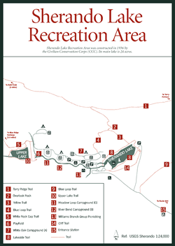
[Fig. 42] Sherando Lake has been popular with residents of eastern Augusta County since its construction by the Civilian Conservation Corps (CCC) in 1936. The beautiful, 24-acre main lake is set in a mountain hollow on the east flank of steep Torry Ridge, less than 5 miles from the Blue Ridge Parkway. The lake has a swimming area with a sand beach and a bathhouse with warm showers. The large, sturdy buildings are consistent with durable CCC construction. Those who prefer shade to the sunny beach can spread blankets on the spacious lawn beneath giant oak trees.
Picnickers also have shade at widely spaced lakeside tables beneath a canopy of deciduous trees. While the hamburgers are frying on the grill, families can hike the Lakeside Trail, which makes an easy 1-mile loop around the lake. Someone's got to go find Dad, who's found a spot between some alders where he can cast to largemouth bass, bluegill, redear sunfish, or stocked trout.
An upper lake (7 acres) was constructed in 1958 for flood control. Anglers who desire a more remote experience prefer this lake, which also has an encircling trail for bank fishing. No trout license is required from June 16 through September 31, when general statewide fishing regulations apply. From October 1 through June 15, a trout license is required. A National Forest Stamp is required all year and so is a Virginia fishing license. Visitors who come to the recreation area during the fall hunting season should wear blaze orange on the trails. The surrounding national forest is heavily hunted, especially during the two-week deer season in November.
In addition to easy trails around both the upper and lower lake, Sherando Lake Recreation Area offers several other paths with more strenuous climbs up the surrounding mountains. The .75-mile Cliff Trail (unblazed) on the eastern side of the main lake can be combined with the lakeside trail for a loop hike with excellent views. The 2.5-mile orange-blazed White Rock Gap Trail follows Back Creek upstream from the upper lake, past an old homesite, and out on the Blue Ridge Parkway, milepost 18.5. Defoliated and dying hardwoods along the trail are evidence of gypsy moth damage. Hemlocks also show the effects of a pest with no known natural enemies, the hemlock wooly adelgid.
Blue Loop Trail. [Fig. 40(2), Fig. 42(4)] Beginning near site #6 in Campground A, the Blue Loop Trail climbs .9 mile to the top of Torry Ridge on the northwestern side of the main lake where it joins the Torry Ridge Trail. After a 1-mile walk northeastward along Torry Ridge, with views of Sherando Lake below, the Blue Loop Trail branches to the south and descends to the entrance road on the east side of the recreation area.
[Fig. 40(15)] St. Mary's Wilderness—even the name sounds like a sonnet on a breeze. A tinkling of water over moss-covered rocks. A play of light and shadows on crystal-clear pools. St. Mary's Wilderness has all these and more. In fact, this 10,090-acre wilderness would do better with a less lyrical name. The fragile beauty hinted at in the name draws so many hikers, campers, and partiers that the wilderness has been "loved to death," as one ranger put it. The well-traveled footpath up lovely St. Mary's gorge and the accompanying trail of human detritus has somewhat marred the wilderness ambiance St. Mary's once had.
The St. Mary's River empties a steep, narrow gorge on the southwest side of Big Levels in the southern tip of Augusta County. St. Mary's Falls, a double waterfall over big rock boulders about 2 miles up the gorge, is the destination for many hikers. A refreshing pool collects water at the bottom of the falls. Just about every level spot along the way has remnants of campfires.
Humans are not alone in leaving tracks in the gorge. In fact, torrential downpours from Hurricane Camille in 1969 and Hurricane Agnes in 1972 wiped out an old logging road up the gorge, divided and changed the lower course of the stream, heaped debris into great piles across what road remained, and helped a group of citizens obtain wilderness designation for St. Mary's in 1984. Of course, had the area not been mined and logged in the early 1900s, the trees and soil may have been better able to withstand the powerful floodwaters. Acid rain has been blamed for decimating the native trout fishery here, but some brookies remain to give catch-and-release fly-fishermen a thrill. Only single barbless hooks may be used.
Nature lovers and trout anglers who seek solitude should look elsewhere or visit the area during off-seasons. However, St. Mary's does have a lot to offer. Its reputation as a first-class mountain gorge along the pretty St. Mary's River is well deserved.
About 17 miles of trails are in the area. Exploring some of the lesser-used trails turns up more waterfalls and rock cliffs and remnants of former manganese mining, including a settling pond, an old railroad grade, and several concrete footings of a former mining camp. A topo map and a compass are always a good idea when hiking such wilderness areas. Conscientious hikers and anglers help not only by packing out their own candy wrappers and aluminum cans but also by picking up trash left by others.
Several springs and freshets entering St. Mary's along the trail are good places to look for moisture-loving wildflowers. These include spotted touch-me-not or jewelweed (Impatiens capensis), jack-in-the-pulpit (Arisaema triphyllum), and the tiny, four-petaled white blossoms of cut-leaved toothwort (Dentaria laciniata). Mayapple or mandrake (Podophyllum peltatum) and hay-scented ferns carpet the forest floor in places. The dramatic red spikes of the cardinal flower (Lobelia cardinalis) are occasionally found. Where sunlight bathes the streambanks, thickets of blackberry, purple-flowered raspberry, multiflora rose, and honeysuckle thrive.
Tulip poplars, hemlocks, and oaks make up much of the canopy along the stream. Oaks and hickories typical of eastern deciduous forests dominate the slopes, while a few stunted table mountain pines can be found mixed in with chestnut oaks, hickories, and pin oaks in the harsher environment of the exposed ridgetops.
In midsummer, black bears are attracted to sun-ripened highbush blueberries (Vaccinium corymbosum) and cranberries (Vaccinium macrocarpon) at Green Pond. Green Pond, fed only by precipitation, is on the spreading, relatively flat top of a mountainous area known as Big Levels. A layer of peat forms an impenetrable basin that holds the water. The pond usually dries up in summer.
Signs of bear activity include scrape marks in rotting logs where bears have searched for ants and shredded bark and vertical tooth marks on pine trees where bears have slurped up pine resin. A bear also will pick a prominent tree along a trail and stand on its hind legs while rubbing itself against the tree, occasionally biting and scratching the tree. These "bear trees" serve to notify other bears of territorial claims. Bears sometimes get in the habit of walking in each other's footprints to and from feeding areas such as the blueberry patches at Green Pond. Gradually, a zigzag trail of paw indentations develops. If the bears abandon the trail, seeds pressed into the paw prints will sprout and form a zigzag trail of grass clumps.
Ruffed grouse, woodcocks, wild turkeys, white-tailed deer, gray squirrels, gray foxes, skunks, and chipmunks are also in the area. The unbroken woods are a haven for species such as the yellow-eyed vireo, ovenbird, wood thrush, pileated woodpecker, scarlet tanager, worm-eating warbler, and hooded warbler.
St. Mary's Trail. [Fig. 40(16)] This is the main trail of the wilderness. The unblazed path leads up a scenic narrowing gorge toward St. Mary's Falls. After a stream crossing, which can be treacherous in freezing weather, and .5-mile short of St. Mary's Falls, the trail forks. St. Mary's Trail makes a right turn to head south up Mine Bank Mountain to a boggy area called Green Pond, located just outside the wilderness. St. Mary's Falls Trail, however, continues along the main stream and dead-ends at a double waterfall at the base of steep rock cliffs.
[Fig. 40(3)] In a mountain gorge in western Nelson County is Crabtree Falls, consisting of five tiers of major falls and several smaller ones. Crabtree Falls plummets 1,200 feet down the northern flank of a 4,063-foot-high mountain called The Priest. The icy waters of the falls are in the headwaters of the Tye River, which gained notoriety in the devastating flooding rains of Hurricane Camille in 1969. The Tye River nearly moved the little community of Massies Mill on VA 56 off the map.
The falls have their own reputation for taking lives with no help from the Tye. Over the years, 22 people have fallen to their death. Many of the accidents occurred when people at the top tried to get a closer look by walking out onto the rocks. These rocks are covered with a clear, algaelike material which makes footing very treacherous. The U.S. Forest Service has installed handrails, steps, observation platforms, walls, and warning signs to make the falls accessible and safe. With signs and railings now in place, such accidents can be avoided by staying on the trail.
Despite the remote location high in the Blue Ridge, the falls are sought after for their scenery by hikers and photographers. The footpath to the falls leads from the lower parking lot across a beautiful arched wooden bridge that spans the South Fork of the Tye River. Then the trail winds through hemlocks and past an old family graveyard. It's an easy 10-minute walk to the first of five major cascades.
From there, the hiker climbs 1.7 miles up a steep trail with switchbacks. Moist air from the falls makes ideal habitat for several varieties of ferns, mosses, and wildflowers. Along the way, viewing platforms with benches enable hikers to catch their breath while enjoying views of the cascades, and children like to investigate the small cave on the trail. At the top, the trail continues 1.2 miles farther along Crabtree Creek to Crabtree Meadows parking lot on VA 826 (Crabtree Farm Road).
A .5-mile hike east on VA 826 from the upper parking lot will take you to a junction with the Appalachian Trail and Shoe Creek Trail. Just 1.2 miles east on the AT are rocky outcrops on the quiet summit of The Priest that overlook Rockfish Valley in Nelson County far below. The Shoe Creek Trail leads 3.5 miles south down the mountain to Piney River, a stocked trout stream on the Nelson County/Amherst County border. The trail can be reached from the bottom via VA 827 (Perkins Mill Road) west of Massies Mill and northwest of Piney River.
The state trout hatchery at Montebello is just 3 miles west on VA 56 from the lower parking area of Crabtree Falls. Visitors are invited to feed the trout and use the picnic facilities.
[Fig. 40(5)] The 7,580-acre Mount Pleasant National Scenic Area was designated by Congress in 1994 as one of only seven such areas in the country. Here, the 6.2-mile Henry Lanum Trail forms a loop connecting the summits of the two highest mountains of the Pedlar Ranger District. Mount Pompey is 4,032 feet high and Mount Pleasant is 4,021 feet high.
Multitiered flat outcroppings of pre-Cambrian granite typical of the Blue Ridge Mountains provide breathtaking panoramic views of the valleys formed by the Piney River and Buffalo River.
Chestnut oak, yellow birch, and pignut hickory are in the hardwood canopy, while mountain laurel, rhododendron, wild hydrangea, mountain ash, highbush blueberries, and witch-hazel can be found in the understory. Wildflowers to look for include starry campion, tiger lily, bloodroot, and Indian pipe.
The forested mountain slopes provide acorns, hickory nuts, grapes, and blue-berries, staples in the diets of black bear. White-tailed deer come into the high mountain fields and meadows to browse at dusk. Bobcats, wild turkeys, red and gray squirrels, gray foxes, and cottontail rabbits also inhabit the woods. The high peaks are perfect places to observe the annual fall hawk migration.
The 3-mile Hotel Trail, completed in 1989, makes a 7.5-mile loop using part of the Appalachian Trail (AT). This trail takes off from the right of the parking lot as you enter from FR 48. It winds through open fields and meadows, along Little Cove Creek, and intersects with the AT at Cow Camp Gap. A three-sided AT shelter is located nearby. Hikers can then hike to the northeast on the AT about 2 miles to Hog Camp Gap. From there, it's a 10-minute hike back to the parking lot on FR 48.
In early summer, hikers along the trails in the Mount Pleasant National Scenic Area may notice trees losing their leaves. They may also hear the constant sound of something raining from above. What they're seeing and hearing is an infestation of the fall cankerworm, which covers about 500 acres of the Pedlar Ranger District, extending southward to US 60 (see Ghost Forests).
Read and add comments about this page