 Glenwood
Ranger District Glenwood
Ranger District
Glenwood
Ranger District Glenwood
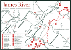
Ranger District The Glenwood Ranger District, the northernmost district of the Jefferson National Forest, is in the mountains of the Blue Ridge northeast of Roanoke and just east and south of the James River in Botetourt and Rockbridge counties. Interstate 81 and the towns of Troutville, Buchanan, and Glasgow are on the western side.
The major tract of the district's 74,128 mountainous acres lies between the James River on the west and the crest of the Blue Ridge Mountains on the east. On the northern end, the James turns east and cuts through the Blue Ridge to enter the Piedmont. Just north of the river is the Pedlar Ranger District, the southernmost district of the George Washington National Forest. A 53-mile stretch of the 2,150-mile Appalachian Trail (AT) and 40 miles of the Blue Ridge Parkway run southwest/northeast through the district.
For 13 miles on the southern end, the Glenwood becomes a narrow band bordering the Blue Ridge Parkway. Another small tract lies on North Mountain to the west, across the Great Valley of Virginia where Alleghany, Botetourt, and Rockbridge counties meet. This little piece of the Glenwood abuts the James River District's eastern border.
Two wilderness areas—James River Face [Fig. 40(10), Fig. 41] and Thunder Ridge [Fig. 40(11), Fig. 41]—protect 11,500 acres of some of the most rugged, wild, and botanically diverse mountains in the state.
Cave Mountain Lake Recreation Area [Fig. 40(12)], a hub of activity on the Glenwood, is located near the northeastern end of the district at one of very few places that's not steep. North Creek Campground [Fig. 40(13)], in the heart of the district east of Buchanan, is the perfect base camp for trout anglers, hikers, wildlife watchers, and naturalists. Backcountry camping is permitted anywhere in the national forest except where posted. Commercial campgrounds are also in the area.
The district is known by area anglers for both its warm-water and cold-water fishing, by hikers and equestrians for its challenging trails, and by paddlers in the James River Gorge for the spectacular scenery of James River Face Wilderness.
The Glenwood Information Center is located in Natural Bridge [Fig. 40(8)] near the intersection of US 11 and VA 130. The district office is about 1.5 miles south of Natural Bridge on VA 130.
White-tailed deer and wild turkeys are abundant, as are smaller animals such as squirrels, rabbits, raccoons, foxes, opossums, and chipmunks. Black bears, normally solitary creatures, are spotted from time to time in a patch of blueberrries. In summer, during the breeding season of bears, a male may follow a female along a slope as they methodically lift rocks in an endless search for grubs, ants, or salamanders. Bears will even endure hornet stings to get at the larvae in a nest.
A rich variety of plant and animal communities accompanies the various habitats of the district. In thickets at the edge of Cave Mountain Lake you may hear the slow "kaup-kaup-kaup" of the elusive yellow-billed cuckoo. The jay-sized "rain crow" often calls before an approaching storm.
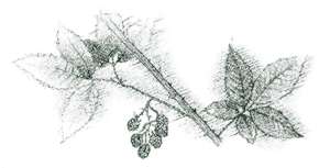
Along streamsides and along the James River are spring peeper frogs, cricket frogs, salamanders, turtles, and water snakes. Honeysuckle, blackberries, multiflora rose, jewelweed, and New Jersey tea (Ceanothus americanus) thrive along streams, roadsides, and the edges of woods. Fast-growing pokeweed (Phytolacca americana) rises to heights of 10 feet seemingly overnight, giving credence to the phrase "growing like a weed."
Large hemlocks, tulip poplars, and white basswood grow in protected coves above an understory of rhododendron, red maple, greenbrier, grape, poison ivy, and a rich variety of other plants. Such areas attract hooded warblers, Carolina chickadees, Carolina wrens, and wood thrushes, to name a few.
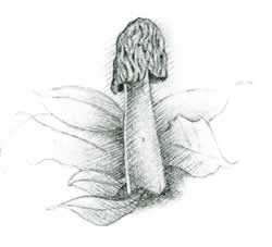
On the dry slopes, under a canopy of hickories, white and red oaks, and pines is an understory of red maples, witch-hazel, black gum, flowering dogwood, highbush blueberry, deerberry, and mountain laurel. Emerging through the leaf litter in spring and summer are such wildflowers as wood lily (Lilium philadelphicum), bloodroot (Sanguinaria canadensis), large-flowering trillium (Trillium grandiflora), and pale, saprophytic Indian pipe (Monotropa uniflora). Indian pipe is white because it does not produce chlorophyll. For nourishment it depends instead on mycorrhiza—an association between a fungus and its roots. Tiny evergreen plants such as pipsissewa (Chimaphila maculata), spotted wintergreen (Chimaphila umbellata), and galax (Galax rotundifolia) add their flowers to the mix.
Galax can be identified by its shiny, dark, evergreen, heart-shaped leaves growing just above the ground. In early summer, a long stalk with milk-white flowers rises above the leaves.
On the high ridges are red and white oak, chestnut oak, pitch pine, and trees of northern forests such as yellow birch, table mountain pine, northern red oak, and even a few red spruce. In many areas of the Glenwood District, the southern pine beetle is devastating stands of southern varieties of pine. When populations are high enough, even Eastern white pines are affected. Some of these white pines grow along North Creek—an important trout fishery. An appreciable increase in sunlight through a destroyed canopy could make the water too warm for trout. Entire plant and animal communities become dependent on both the shade and nutrients in the soil beneath a stand of pines.
The hemlock wooly adelgid is infesting hemlocks in sheltered ravines. Hemlocks also provide shade for mountain trout streams and associated plants, insects, birds, and wildlife.
 Recreation
Areas of Glenwood Ranger District
Recreation
Areas of Glenwood Ranger District Recreation on the Glenwood District is based at four areas—Cave Mountain Lake Recreation Area, Middle Creek Picnic Area, North Creek Campground, and Hopper Creek Group Campground. The Locher Tract, a grassy area on the James River, provides an overnight camping spot for those floating the James River or a base camp for exploring the James River Face Wilderness. All areas are in the wide portion of the Glenwood Ranger District bordered by the James River between Buchanan and Glasgow. The Hopper Creek group facility, open year-round, offers a private area in the northern end of the district for groups of up to 50 people. Reservations are required.
Cave Mountain Lake Recreation Area. [Fig. 40(12)] Scenic Cave Mountain Lake is the centerpiece of this recreation area—easily the most popular spot on the district. A swimming beach, bathhouse, and hookups for the campsites add to its appeal as a family campground. Adjacent to the beach is a large grassy field for sunning and games. Reservations are required for a group picnic area and log picnic shelter.
The Wildcat Mountain Trail, a 4-mile loop over rough terrain, was developed primarily for use by campers. Heading south from the campground, it climbs from 1,200 feet at the campground to 2,700 feet on Wildcat Mountain.
Middle Creek Picnic Area. [Fig. 40(14)] This attractive creekside picnic area near Buchanan provides shade for family outings and proximity to stocked trout waters for anglers. The Appalachian Trail comes through the area.
North Creek Campground. [Fig. 40(13)] This more primitive area is in an area of the national forest where conservation and appreciation of natural habitat take precedence over timber production. North Creek, a cold-water trout stream, drains a scenic deep hollow below 200-foot Apple Orchard Falls. The giant snail-eating ground beetle (Scaphinotis webbi) and oak fern (Gymnocarpium dropteris) are among rare species in 1,825 acres under protection. Despite its primitive nature, the campground is popular and can be full during peak season. Arrive early to assure yourself a site.
Locher Tract. [Fig. 40(7)] The Locher Tract is a primitive picnic area (no tables or running water) consisting of an open grassy field on the James River. A .7-mile nature trail runs along the river, through the woods, and around a beaver pond. Wildlife openings, nesting boxes, grazing areas, and wetlands attract a variety of songbirds, waterfowl, wading birds, amphibians, frogs, and salamanders. Wildflower species are also diverse. Bring insect repellent in warm weather. In addition to the nature trail, the trailhead for the 4.1-mile Balcony Falls Trail is here.
Besides the 53-mile section of Appalachian Trail (AT) running the length of the district, hiking trails lace the area and some are open to equestrians. The 65-mile Glenwood Horse Trail, completed in the early 1990s, provides outstanding riding on terrain varying from gravel roads to difficult single-track trails through mountainous terrain. Area clubs and individuals help take care of the trail. In fact, despite the rough terrain of the Glenwood, most trails are surprisingly well kept, well signed, and easy to follow. That's a good thing because these paths lead to beautiful waterfalls, wild trout streams, unusual topography, and spectacular scenery. With the exception of the AT, trails are only lightly used.
Apple Orchard Falls National Recreation Trail. [Fig. 40(6)] This strenuous 3.4-mile (one-way) hike to a spectacular 200-foot cascade can be combined with the 2.9-mile Cornelius Creek Trail for a challenging loop. See section on Blue Ridge Parkway, Mile 78.4, for description from upper trailhead and directions to lower trailhead.
Apple Orchard Mountain and the hollows along North Creek, as with many cool, moist places in the Appalachians, are the preferred habitat of ginseng (Panax quinquefolium), a perennial herb. This once-common plant suffers from overcollecting. It has long been used as a mild stimulant and aphrodisiac in the Far East. In an attempt to take pressure off the threatened native plant, commercial growing of ginseng is not considered a violation of the Endangered Plant and Insect Species Act. The white to greenish white flower is surrounded by a whorl of three to five compound leaves.
Excellent fishing for smallmouth bass, sunfish, catfish, and muskie is available on the historic James River on the district's border. An especially scenic stretch is where the James cuts a deep gorge through the mountains of the Blue Ridge on the district's northern end (see James River).
Fishing for native and other wild trout is normally reserved for the young and fit who are able to climb into remote hollows to find these cold-water fish. However, in the Glenwood District, state and forest service roads run not only along the stocked trout streams but also along some wild trout waters, making them far more accessible than most trout streams. Sections of North Creek, Middle Creek, and Jennings Creek (marked with white game department signs) are stocked with rainbow, brown, and brook trout. Trout less than 7 inches must be released. No more than six fish may be creeled per day.
The upper section of North Creek (above the first bridge upstream of the North Creek Campground) is designated for special regulations. These special regulations require the use of single-hook artificial lures and the release of all trout of less than 9 inches. The lower portion remains put-and-take fishing for stocked trout. Creel and size limits may vary from season to season. The Glenwood District office or the Virginia Department of Game and Inland Fisheries can provide current regulations.
[[Fig. 40(8), Fig. 23] Natural Bridge in Rockbridge County is one of the Seven Natural Wonders of the World. The 215-foot-high rock span above a narrow gorge lies not near but under the old Valley Pike, US 11. Cedar Creek, which helped sculpt the limestone rock, flows beneath it.
The Monacan Indians marveled at the size of the ancient arch and worshiped it as The Bridge of God. George Washington surveyed it (his initials are still visible on the rock wall), and Thomas Jefferson once owned it. During the Revolutionary War, the bridge was used as a shot tower. Balls of molten lead were dropped from the top, cooled as they fell, and formed round shot.
The bridge is now privately owned but open for public viewing daily. After dark, a sound and light show called The Drama of Creation explains how the 215-foot arch came into being. A hike beyond the bridge leads to lace waterfalls. Trees typical of limestone soils, such as northern white cedar and arborvitae, grow along the path. The shaded gorge offers refuge for northern tree species such as hemlock, beech, and yellow birch.
The same chemistry that formed the bridge also created Natural Bridge Caverns. Tours are conducted daily into the labyrinth of underground streams, waterfalls, and catacombs 347 feet below the surface. A wax museum and gift shop with country crafts and homemade candies are nearby.
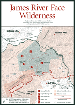 James
River Face Wilderness
James
River Face Wilderness [Fig. 40(10), Fig. 41] The James River Face Wilderness was the first designated wilderness on national forests in Virginia after the 1975 Wilderness Act. It's also one of the largest wilderness areas in the state. The 8,903-acre area, dissected by the Rockbridge County and Bedford County line, is at the northern end of the Glenwood Ranger District, bounded to the north by the James River Gorge. Elevations range from 650 feet at the James River to 3,073 feet at Highcock Knob. (The Appalachian Trail crosses this peak in the southeastern part of the wilderness.)
The area has an unusually large diversity of vegetation, especially in the James River Gorge. Carolina hemlock (Tsuga caroliniana) is at the northern extent of its range here. Paper birch (Betula papyrifera)—the tree with the distinctive white papery bark and black markings characteristic of New England forests—is at the southern extent of its range.
There are six maintained trails, including the Appalachian Trail, within the wilderness. Because of the steep terrain, trails tend to be difficult, with switchbacks. The Belfast Trail, a 2.8-mile (one-way) trail in the western portion of James River Face, has an interesting feature. At about 1.5 miles, the trail leads to the Devils Marbleyard, a large scenic outcrop of huge loose boulders, where views of Arnold Valley and the Thunder Ridge Wilderness are impressive.
Balcony Falls Trail. [Fig. 41(1), Fig. 40(7)] This 4.1-mile path begins at the Locher Tract on the James River. It follows an old woods road about 1.2 miles. It then climbs, with switchbacks, through frequent changes in forest types from pines to mixed hardwoods. At 2.3 miles, it enters James River Face Wilderness and ascends to top-of-the-world views on a ridge. Far below are the town of Glasgow and the James River Gorge, where kayakers and canoeists brave the rapids of Balcony Falls. For trailhead, follow directions to Locher Tract. On the ridgetop, the trail connects to the Appalachian Trail, and to Sulphur Spring, Gunter Ridge, Belfast, and Piney Ridge trails for plenty of circuit options. Note: Horses are permitted on this trail and on connecting Sulphur Spring and Piney Ridge trails.
 Thunder
Ridge Wilderness
Thunder
Ridge Wilderness [Fig. 40(11), Fig. 41] The small, 2,344-acre Thunder Ridge Wilderness lies high on the northeastern slope of the Blue Ridge, its eastern side accessible by the bordering Blue Ridge Parkway. To the north, separated by a narrow corridor of nonwilderness where a forest service road runs down the mountain, is James River Face Wilderness. The road is FR 35, connecting the Blue Ridge Parkway, milepost 71, at Petit Gap (spelled "Petites Gap" and "Petite Gap" on various maps) with recreation areas in Arnold Valley on the district's northern end.
Elevations on Thunder Ridge range from 1,320 feet at the northwestern corner to 4,200 feet on Apple Orchard Mountain. The Appalachian Trail runs the ridgeline, cutting through the southern edge of the wilderness and coming in again at the northern section. A portion of the 65-mile Glenwood Horse Trail goes through the wilderness beside FR 35. Other access is limited because of the steep, rugged terrain, and blow-downs caused by ice storms and winds.
Read and add comments about this page