 The
Blue Ridge The
Blue Ridge
The
Blue Ridge The
Blue Ridge For residents along the old "Valley Pike " (US 11), sunrise over the gentle Blue Ridge and a cup of coffee are a comfortable way to start a day. The mountains are always there—appearing uncomplicated, solid, enduring. Solid and enduring, yes. For the Blue Ridge are not only the highest but are among the oldest mountains of the Appalachians and of the nation. The range is made up largely of billion-year-old metamorphic and igneous bedrock thrust upward with the rest of the Appalachians about 250 to 300 million years ago.
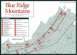
But uncomplicated? The mountains do appear deceptively simple, often wrapped in the soft blue haze that suggested their name. Beginning with the name, however, this range is anything but simple. First, there's a distinction between the terms Blue Ridge province and Blue Ridge escarpment. The rounded, weathered Blue Ridge province—the defining eastern boundary of the Appalachians—extends from northern Georgia 615 miles northeast to southern Pennsylvania. The range separates the Great Valley of Virginia on the west from the Piedmont on the east. The Blue Ridge province keeps travelers along Interstate 81 company for the highway's entire 323-mile run through the state, though the Massanutten Mountains block the view for 50 miles.
The city of Roanoke—where the Roanoke River cuts through the mountains—is the dividing line between two different configurations of the Blue Ridge province. The ridge that runs northeast from Roanoke is rarely more than 14 miles wide, rising sharply from the valley floor, with smaller associated ridges extending from the main one. Southeast of Roanoke the mountains broaden into a plateau, punctuated with clusters of mountain peaks. The plateau widens to more than 50 miles across at the North Carolina border and 70 miles across farther south.
In Virginia, the plateau is called the Blue Ridge Highlands. The mountain ranges along the western portion of the plateau (along the North Carolina/Tennessee border) are known collectively as the Unaka Mountains. An escarpment along the eastern edge of the plateau plus the narrow ridge of the Blue Ridge that runs north from Roanoke to southern Pennsylvania makes up the Blue Ridge front or escarpment, or simply the Blue Ridge.
Travelers can ride the crest of the Blue Ridge on the Skyline Drive (north of Waynesboro) and the Blue Ridge Parkway (south of Waynesboro), with grand views of the Piedmont to the east and the mountains and valleys to the west. The ridge they ride and the mountains of the Blue Ridge province to the west—though still impressive—are now rounded, weathered. Geologists use the term "subdued" for these worn-down remnants of ancient mountains. Crags, cliffs, and talus slopes are rare. Instead of peaks, the mountains generally have rounded summits, which slope gradually away to steep sides and ravines.
Forces that formed the ancient rocks of the Blue Ridge are only partially understood, for the events were many and complex. Of course, the fact that the occur-rences took place millions, even billions of years ago further clouds the picture. Geologists believe the Grenville Orogeny—a collision of earth's sliding plates—formed the basement rock of the Blue Ridge, forcing up the first Appalachians that wore down before the present-day mountains formed. That event happened more than 1 billion years ago. As the continents broke apart about 750 million years ago, a sustained period of volcanic action followed. Evidence of viscous lava flows can still be found at Mount Rogers in the southwestern Blue Ridge Highlands.
A final orogeny—again a collision caused by continental drift—ended a mere 250 million years ago. The basement rocks were once again forced up and over adjacent younger layers of rock to the west. If layers of younger sedimentary rock such as limestone were on top, they completely eroded away to expose the ancient bedrock once again. Because of the east-to-west direction of the thrust, younger rocks in Shenandoah National Park are exposed to the west, and older Precambrian granites to the east. The metamorphic and igneous rocks—gneisses, schists, quartzites, greenstones, and granites—were formed by intense pressure and heat, and left few fossils.
The Roanoke and two rivers to the north—the James and the Potomac—still follow their ancestral course, predating the Blue Ridge. These three rivers carved gorges, or water gaps, through the uplifting Blue Ridge, keeping pace with the forces creating the mountains.
In other cases, wind gaps are left where a river used to flow through the rising mountains, but did not keep up with the mountain's growth. Streams draining the Shenandoah Valley left evidence of several attempts to make an eastward escape before being diverted north to the Potomac. The valley was on a much higher plain, and the mountains were possibly little more than knobs showing above the horizon. But the streams easily wore down the highly erodible limestone and gradually wore down tougher sandstone as the valley formed, but the resistant granite and gneiss bedrock of the Blue Ridge on the eastern edge was a formidable barrier.
As individual streams were diverted north, they joined the Shenandoah River. Examples of the wind gaps they left behind are Goose Creek at Manassas Gap (where I-66 crosses the Blue Ridge east of Front Royal), Gap Run at Ashby Gap (10 miles north, at the US 17 crossing in Clarke County), and Beaverdam Creek at Snickers Gap (9 miles farther north at the VA 7 crossing).
The South River at Waynesboro once flowed east through Rockfish Gap into what is now the Rockfish River in Nelson County. It, too, was finally "captured" by the Shenandoah and diverted to the Potomac.
Altitudes in the narrow Blue Ridge province north of Roanoke rarely reach heights above 3,000 to 3,500 feet. Exceptions are The Priest in Nelson County, Mount Pleasant in Amherst County, and, on the Page/Madison county line, Hawksbill and Stony Man mountains. All are above 4,000 feet.
In the Iron Mountains of the Blue Ridge Highlands to the south, however, are Virginia's highest mountains. Mount Rogers is 5,729 feet and Whitetop Mountain is 5,540 feet. This collection of summits in the southeastern corner of the Blue Ridge Highlands are the remnants of the volcanism of 750 million years ago. The mountains and associated alpine forest communities are a centerpiece of Mount Rogers National Recreation Area.
Extremes in elevation, among other factors, result in great variety of forest communities. Forest types range from southern hardwoods such as sycamore, persimmon, American beech, and pawpaw at lower elevations to a few patches of spruce-fir forests on high summits. Between are typical oak-hickory forests, cove forests of white basswood, tulip poplar, and Eastern hemlock, and, on upper and north-facing slopes, tracts of northern hardwoods such as yellow birch, sugar maple, and American mountain-ash. Dominant trees, however, account for just 100 of the 1,600 species of higher-order plants identified in just the northern section of the Blue Ridge.
The diverse and complex communities of dominant trees and other species—shrubs, flowers, ferns, aquatic life, wildlife, insects—associated with the various types of forests are discussed in the introduction and as they relate to each site.
The highlands, unlike most of the more sharply defined Blue Ridge province north of Roanoke, were broad enough for entire communities to settle. Examples are the towns of Troutdale and Independence in Grayson County, Fancy Gap in Carroll County, Meadows of Dan in Patrick County, and Floyd in Floyd County. The descendants of tough German and Scots-Irish settlers who scratched out an existence on thin mountain soil still hold to many customs and traditions of their ancestors.
During the hard work day, they would compose songs in their minds while planting cabbage, digging potatoes, tending cattle, or hanging leaves of Burley tobacco in their barns. Before television, families and neighbors would gather on front porches in the cool of the evening to make music and tell tales. On Saturday nights, they celebrated the week's work not as couch potatoes, but with exuberance. They'd break out the banjo and fiddle. The entire community would gather at a local barn to clap their hands, stomp their feet, and swing that gal.
Today, traditional mountain music—and the weekly barn dances—are more than passing fancies. The driving rhythm and energetic dances are in the blood. In the town of Floyd (on US 221 in Floyd County), for example, the rollicking music of the Friday Nite Jamboree still rings down the mountain hollows. On the third Saturday of each month, the people of Galax, on the Carroll/Grayson county line, celebrate with their own Mountain Music Jamboree. Galax is also home to the world-renowned Old Fiddlers Convention each August. Many communities celebrate apple-butter making, maple-sugar time, storytelling, mountain crafts, squaredancing, and harvest time (see Appendix C).
Read and add comments about this page