 Stone
Mountain Stone
Mountain
Stone
Mountain Stone
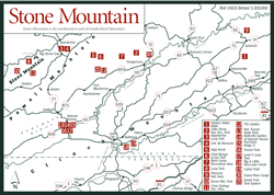
Mountain [Fig. 12] Stone Mountain is actually the mauled and contorted northeastern end of magnificent Cumberland Mountain that defines Virginia's southwestern border with Kentucky. Six miles below Pennington Gap in Lee County, the Kentucky/Virginia line veers off from Cumberland Mountain toward the west. At that point, where the mountain belongs to Virginia on both sides, it first becomes Stone Mountain, then Little Stone Mountain, stretching its stalwart ridgeline some 28 miles more, past Big Stone Gap, to Norton in Wise County.
Then the mountain that ages ago rivaled the 125-mile-long Pine Mountain to the west becomes jammed and confused. After Stone Mountain formed, continuing pressures caused by the collision of the African and North American continents crushed the part now called Little Stone Mountain. It pushed it up against Powell Mountain, and folded it into a boomerang shape around Powell Valley. Its eastern and southern borders are marked by the Guest and Clinch rivers.
Road cuts on the north side of Little Stone Mountain offer a great comparison between the nearly horizontal rock formations of the Appalachian Plateau and the steeply tilted layers of the Valley and Ridge province. Take US 23, which runs parallel to the Powell River, for this look back to the violent end of the Paleozoic era some 250 to 300 million years ago. In the Pennsylvanian and Permian periods of this era, tremendous pressure from the earth's shifting plates gradually buckled the earth's crust. A road cut often reveals stratifications turned nearly sideways.
Today, the Clinch Ranger District of the Jefferson National Forest offers access to a diverse potpourri of habitats and scenery on Stone Mountain. These include northern hardwood forests, southern hardwoods, cove forests, pine forests, old growth forests, rhododendron thickets, beaver ponds, marshes, bogs, hemlock-lined stony creeks, deep gorges, sheer cliffs, and rocky outcrops. All this variety remains relatively unassaulted by tourist-season crowds.
A long, narrow strip of national forest runs along Stone Mountain from about 8 miles west of the Lee County line to Norton, squeezing between Big Stone Gap and Appalachia.
[Fig. 12(11)] Cave Springs may be used as a base camp to explore rhododendron-lined hiking trails through a mostly hardwood forest dotted with large boulders and steep cliffs. One trail leads to a scenic overlook and cave where a spring begins. The west end of the 14-mile Stone Mountain Trail starts here. The picnic area has a small swimming lake. Campsites are shaded with hardwoods and offer privacy. The elevation at the recreation area is 1,500 feet, with trails climbing Stone Mountain to 2,750 feet above the campground.
[Fig. 12] This hidden jewel of the Clinch Ranger District features a picturesque 92-acre lake with secluded coves surrounded by marsh grasses and hardwood forests of red oaks, white oaks, and hickories. With no gasoline-powered motors allowed, the lake attracts only those who enjoy quietly probing the shoreline by canoe or casting from a john boat for largemouth bass and sunfish around the dead trees emerging from the shallows. Early and late in the day, a raccoon, muskrat, or fox may come for a drink at the lake's edge. The lake can also be explored by foot on the encircling trail. A spur connects to the middle of the more challenging Stone Mountain Trail.
Lake Keokee Loop Trail. [Fig. 12(8)] Beyond the edges of this easy trail around Lake Keokee, an occasional frog plops in the water. The turquoise wings of a dragonfly clinging to marsh grass are iridescent in the afternoon sunlight. Indian pipe (Monotropa uniflora) pokes its white flower out of the leaf litter under the oaks. From the other side of the lake, a spur leads in less than 1 mile to Stone Mountain Trail at Olinger Gap. After crossing Stone Mountain Trail and continuing along this spur another .5 mile down the south side of Stone Mountain, this trail connects with VA 622 at Old Still Hollow.
 Stone
Mountain Trail
Stone
Mountain Trail [Fig. 12(10)] This rugged, 14.3-mile trail, straight as a Kansas highway, follows the crest of Stone Mountain between Big Stone Gap and Cave Springs Recreation Area. Visitors who don't have a day or two set aside to hike it should take at least part of a morning or afternoon to explore the eastern end of the trail. After walking up a series of rock stairs built in the 1970s by the Youth Conservation Corps, hikers will enter a deep hemlock forest lining the banks of Roaring Branch. Miniature waterfalls among the sculpted sandstone boulders are picture perfect.
A stand of old growth hemlocks that has evaded the woodsman's axe for more than 300 years is on this section of the trail. Then, at 3.5 miles, hikers can catch their breath at High Butte, a scenic rock outcrop with the Powell River to the south, and Black Mountain and Kentucky to the north.
[Fig. 12(3)] A challenging trail if you take it fast, it is negotiable for the average hiker who has time to rest along the way. The Appalachia Loop Trail is on Little Stone Mountain, typical Appalachian Plateau country, with profuse boulderfields and sand-loving rhododendron thickets.
[Fig. 12(4)] Located on US 23 at Big Stone Gap, 18 miles north of Natural Tunnel State Park [Fig. 12(13), Fig. 16] near Duffield, the museum tells the story of exploration and development of southwest Virginia. The transformation of Big Stone Gap into a vital cultural area after coal and iron ore were discovered in the area in the late 1870s is featured in the main gallery on the first floor.
Second-floor exhibits tell of local people at the turn of the century. The outside world was having a profound influence as mail-order catalogs, photographs, radios, and railroads ended the people's isolation. The flow of early settlers into and through southwest Virginia as the Wilderness Road was opened through Cumberland Gap is chronicled on the third floor.
The museum is administered by the Virginia Department of Conservation and Recreation, which operates the state parks. Information on one of the state's newest parks, Karlan, is available here. Karlan is located off US 58 in Lee County, about 10 miles east of Cumberland Gap, Tennessee (see Karlan State Park). Other attractions in the town of Big Stone Gap include the June Tolliver Playhouse, home of the seasonal outdoor performance of the musical Trail of the Lonesome Pine, based on the book by John Fox Jr.; the John Fox Jr. Museum, the author's home which is now a Virginia Historical Landmark; and the Harry W. Meador Jr. Coal Museum.
Read and add comments about this page