State Lands
House Mountain State Natural Area
[Fig. 24(4)] The 500-acre House Mountain area was acquired in 1986 by the
Trust for Public Land, then purchased in 1987 by the Department of Environment
and Conservation. The north side of the 2,100-foot-high mountain, the highest
point in Knox County, is still privately owned. The public area offers views
of the Great Smoky Mountains, the Cumberland Mountains, and the beautiful farmlands
and hills surrounding the mountain. The House Mountain area is still largely
undeveloped with no buildings, restrooms, or water supply, and the park is
for day use only. There is a system of trails that range from easy to strenuous.
Call the natural area to request trail descriptions and a map.
- Directions: From Knoxville, take TN 11W north from I-40
and travel approximately 10 miles to Idumea Road. Turn left and go 0.5 mile
and turn left on Hogskin Road. The parking area is 0.7 mile ahead on the
right.
- Activities: Hiking.
- Facilities: 5 miles of hiking trails.
- Dates: Open Tuesday through Sunday, year-round.
- Fees: None.
- Closest Town: Knoxville, 10 miles.
- For more information: House Mountain State Natural Area,
PO Box 109, Corryton, TN 37721. Phone (423) 933-6851.
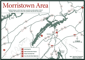
Panther Creek State Park
[Fig. 24(3)] Located on the shores of Cherokee Lake, a TVA reservoir, Panther
Creek State Park offers a variety of recreational activities. Panther Springs,
which creates Panther Creek, is said to have been named by an early explorer,
Colonel Bradley, who claimed to have shot a panther that fell into the spring.
Development of the state park began in 1965 when the state purchased 122 acres
for a day-use area. The state owns 1,435 acres.
- Directions: Panther Creek is accessible from US 11E between
Knoxville and Morristown. A sign directs travelers to the park.
- Activities: Hiking, fishing, swimming, boating, playground
sports, biking, horseback riding.
- Facilities: Campsites, bathhouses, swimming pool, playground
with recreational equipment, boat-launching ramp, hiking and horse trails,
tennis courts, sand volleyball, and laundry. Some facilities are only available
seasonally.
- Dates: Open year-round.
- Fees: There is a charge for camping.
- Closest Town: Jefferson City, 8 miles.
- For more information: Superintendent's Office, Panther
Creek State Park, 2010 Panther Creek Park Road, Morristown, TN 37814. Phone
(423) 587-7046.
Warrior Path State Park
[Fig. 25(5)] The park gets its name for its proximity to the old Cherokee
trading and war path. The 950-acre area was first purchased by TVA in 1952
and later turned over to the state. Situated within a few miles of three major
cities, Kingsport, Bristol, and Johnson City, Warrior Path receives lots of
attention, but it has facilities capable of handling large amounts of traffic.
Situated on the shores of Fort Patrick Henry Lake, the reservoir offers additional
recreational opportunities. Nearly 9 miles of trails wind through the park,
making hikes of various lengths possible. All trails are easy to moderate.
- Directions: The park is located 2 miles southeast of Kingsport
and accessible on TN 36. From I-81, exit on TN 36, go north to Hemlock Road
and turn right to reach the park entrance.
- Activities: Hiking, biking, horseback riding, swimming,
fishing, boating, water-skiing, golfing, tennis.
- Facilities: Campsites, camp store, snack bar, recreation
center, bathhouses, boat-launching ramp, marina and boat cruises (seasonal),
golf course, Olympic-size swimming pool (seasonal), picnic area, playgrounds,
tennis courts, hiking trails.
- Dates: Open year-round.
- Fees: There is a charge for camping.
- Closest Town: Kingsport, 2 miles.
- For more information: Warrior Path State Park, POB 5026,
Kingsport, TN 37663. Phone (423) 239-8531.