 Blood
Mountain
  Blood
Mountain
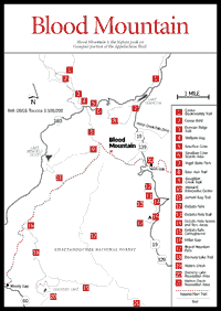
 Blood Mountain [Fig. 24] is the highest peak on Georgia's portion of the Appalachian Trail and the state's sixth highest mountain. The Blood Mountain Wilderness is the first designated wilderness area along the Appalachian Trail as the hiker heads north toward Maine. Some believe the name came from a bloody battle between the Cherokee Indians and Creek Indians long before white men arrived in the area. Other theories trace the name to red lichen or Catawba rhododendron growing on the rocky summit.
At 4,461 feet, it overlooks an area rich in streams, hiking trails, and scenic recreation spots, one of which—Sosebee Cove [Fig. 24(5)]—is probably Georgia's only north-facing cove traversed by a paved road at such a high elevation. It has a boulderfield, northern hardwoods, and large buckeyes and provides an example of how tulip poplar takes over following too-thorough logging of cove hardwood forests.
[Fig. 24(12,14)] DeSoto Falls was named for the Spanish explorer Hernando De Soto because a piece of armor attributed to his expedition was supposedly found in the area. The scenic area is located in rugged, mountainous country with exceptional views. Elevations in this 650-acre area of clear streams feeding Frogtown Creek vary between 2,000 and 3,400 feet. Visitors can hike to view two waterfalls.
[Fig. 24(13)] .8 mile. The trail passes by the two lower cascades of DeSoto Falls and is relatively easy. The trailhead is in the DeSoto Falls Recreation Area.
[Fig. 24(15)] This is rugged, mountainous country with exceptional views and several beautiful waterfalls. It is adjacent to DeSoto Falls Scenic Area (see above).
[Fig. 24(10)] This beautiful stone center was built from 1934 to 1938 of native rock by the Civilian Conservation Corps. It was placed on the National Register of Historic Places in 1977 and is now owned by the Georgia Department of Natural Resources. The breezeway is the only place where the approximately 2,135-mile-long Appalachian Trail goes through a man-made structure. Approximately 1,000 hikers each year pass through the breezeway, hoping to hike the entire length from Georgia to Maine. There is a store here (owned by Jeff and Dorothy Hansen since 1983) with outdoor books, mountain crafts, gifts, maps, clothing, and camping equipment.
 Neel's
Gap to Blood Mountain Hike
 About 2 miles. An enjoyable day trip with many scenic vistas is a climb up Blood Mountain (4,458 feet). The trail is generally steep and rocky in many places, but it is easy to follow. Near the summit hikers will be rewarded with several picnic rocks and superb vistas from rock outcrops, including views of Mount Yonah, Tray Mountain, Lake Winfield Scott, and Slaughter Mountain. An old stone cabin, built by the Civilian Conservation Corps in the 1930s as an Appalachian Trail shelter and listed on the National Register of Historic Places, sits near the top. This is the highest point on the Appalachian Trail in Georgia. It is the state's most-hiked portion of the Appalachian Trail.
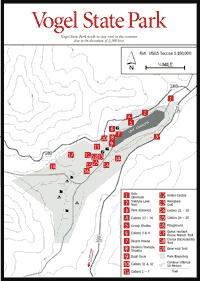
[Fig. 24(7), Fig. 25] One of the prettiest state parks in all of Georgia. It is nearly 2,500 feet in elevation, usually affording cool temperatures even during hot summer months. The park can be crowded in summer, and campsites fill up quickly. There are short hiking trails in the park as well as the trailhead for the challenging 12.5-mile Coosa Backcountry Trail.
BEAR HAIR TRAIL. [Fig. 24(8)] This 3.6-mile orange-blazed loop trail is ideal for family hikes. It is of moderate difficulty, beginning and ending in Vogel State Park. Most of the trail is in the Chattahoochee National Forest.
COOSA BACKCOUNTRY TRAIL. [Fig. 24(1)] 12.5-mile loop. This strenuous trail is marked with yellow blazes and signs and for the most part is easy to follow. It fords streams on its lower part and traverses the high Duncan Ridge, including Coosa Bald [Fig. 24(2)] at over 4,000 feet. It is recommended that hikers take more than one day to hike the entire route, although it can be done in one long day, particularly during the longer daylight hours of spring and summer. A permit is required and is available free, together with a trail map, at the Vogel State Park Visitor Center.
BYRON HERBERT REECE NON-GAME NATURE TRAIL. [Fig. 25(17)] An easy, 1-mile loop interpretive trail.
 Helton
Creek Falls Trail and Drive
 An easy .2-mile trail leads to the falls from a parking area on Helton Creek Road. About 1.1 miles south of Vogel State Park at Lark Gap, a rough dirt road (FS 118) goes down Helton Creek. After 1 mile, the road becomes gravel. With care, in 1.2 miles, you can reach the very beautiful Helton Creek Falls even in an average car.
To continue on to this road's terminus at the Russell Scenic Highway requires great care. Because of potholes and creek fordings, it is recommended only for four-by-four and high-clearance vehicles. There are actually two falls, one about 30 feet high and visible from the road; the other, twice as high, is about 150 feet upstream.
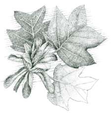
[Fig. 24(6)] This 175-acre tract of hardwood timber, largely part of the Blood Mountain Wilderness, is a memorial to Arthur Woody, who served as a Forest Service ranger from 1911 to 1945. Ranger Woody, the "Barefoot Ranger," loved this peaceful cove and negotiated its purchase for the Forest Service. Rare and beautiful wildflowers and ferns abound. In the boulderfield above the road, there is rich, high-altitude herb flora, including Dutchman's breeches, squirrel corn, waterleaf, and others. Here also is found the rare yellowwood tree and representative northern hardwoods, such as yellow birch. A salamander-rich branch flows down the cove. There are several large buckeyes below the road, along with a stand of second-growth yellow poplar that followed heavy logging that reduced the diversity of the cove forest. A .3-mile trail consists of two linked loops.
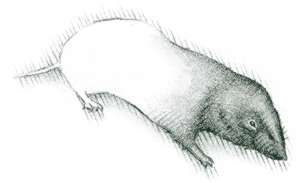
Woody, with his own funds, brought the first deer back into the mountains after they had been extirpated. He always claimed his father killed the last deer in north Georgia in 1895.
[Fig. 24(3)] 20.4 miles and strenuous. On this blue-blazed trail, one can traverse the longest contiguous ridgeline leading off the main Blue Ridge. The trail's eastern terminus is to the west of Blood Mountain at Slaughter Gap [Fig. 24(9)], then crosses northwest through Wolfpen Gap [Fig. 24(4)] and Coosa Bald [Fig. 24(2)], then goes westward to Mulky Gap and intersects with the Benton MacKaye Trail.
 Lake
Winfield Scott Recreation Area
 [Fig. 24] This lovely, clear, 18-acre mountain lake, which is owned and managed by the U.S. Forest Service, is the source of Cooper Creek and contains a large population of rainbow trout. A nice hiking trail circles the lake.
JARRARD GAP TRAIL AND SLAUGHTER CREEK TRAIL [Fig. 24(9,11)] 1.2 miles and 2.7 miles, respectively. These two easy-to-moderate trails provide access to the Appalachian Trail from Lake Winfield Scott Recreation Area. The Jarrard Gap Trail follows portions of an old logging road through cove hardwoods.
[Fig. 24] The gap, with scenic vistas of Yahoola Valley, is marked with a large wooden sign. This is where the white-blazed Appalachian Trail crosses GA 60. A moderate, 1-mile hike to the north leads to a rock-outcrop overlook on the rocky face of Big Cedar Mountain (3,737 feet). A 1.5-mile hike to the south leads to a southerly view of the Yahoola Valley from atop Ramrock Mountain (3,200 feet). Both of these trail sections offer a pretty display of spring wildflowers on this richly wooded Blue Ridge Mountain range.
The overlook offers a scenic vista of Blood Mountain Cove and Blood Mountain. There are hiking trails in the area. The watershed in the foreground is the famous Waters Creek trophy trout stream [Fig. 24(19)].
 Dockery
Lake Recreation Area
 [Fig. 24(20)] Dockery Lake (2,388 feet), nestled within a large cove surrounded by ridgetops and small valleys, offers the forest visitor a wide variety of natural and scenic beauty.
Deer and grouse are common sights. Purple rhododendron blooms in May at higher elevations, while the white variety blooms in mid-June at lower elevations. Native trees such as dogwood, sourwood, locust, and laurel add more color to spring and brilliance to the fall leaf season. Trout fishing is available along the Pigeon Roost Creek and nearby Waters Creek, as well as in the 6-acre Dockery Lake, which is stocked on a regular basis.
DOCKERY LAKE TRAIL. [Fig. 24(18)] 3.4 miles. This moderate-to-strenuous trail provides access to the Appalachian Trail. It winds north 3 miles over portions of an old logging road and terminates at Miller Gap [Fig. 24(16)]. The trail parallels a portion of Pigeon Roost Creek and provides scenic views of nearby mountain ridges and peaks.
Twelve streams either parallel or cross the trail. Stands of hemlock, white pine, hickory, black walnut, and magnolia cling to the mountain slopes of granite and milky quartz. Delicate mosses and colorful lichens adorn the boulders bordering much of the trail. In spring, the trail comes alive with blooming magnolias and wildflowers including wild iris, trillium, bloodroot, and fleabane.
LAKESHORE TRAIL. [Fig. 24(18)] .5 mile. This trail encircles Dockery Lake and is accessible to the handicapped. Footpaths provide access to fishing areas around the lake.
[Fig. 24(21)] Located along a beautiful mountain stream. The headwaters is a trophy trout stream.
 Blood
Mountain Falls
 [Fig. 24(17)] This waterfall is located on Blood Mountain Creek, which flows approximately 20 feet through a rock cut, creating a churning sluice of water. An unmaintained footpath leads to the falls.
Map References: USGS 1:24,000 series: Neel's Gap–Coosa Bald.
Read and add comments about this page