 Darien
Darien
Darien
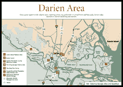
[Fig. 16] This town of only 1,800 people has one of the most colorful histories of any town in Georgia, if not the United States. Once a great seaport on the Atlantic coast, exporting cotton, rice, and timber in several boom and bust cycles, Darien today depends on commercial fishing and tourism. The town's fortunes have always been linked to the propagation and harvesting of the extensive natural resources found in the county and upriver areas. More of Darien's interesting past would be evident if the town hadn't been burned during the Civil War. Despite that infamous event, there are plenty of fascinating sites and nearby excursions to appeal to the visitor. The town has a historic district, a commercial waterfront, nineteenth century churches, Victorian homes, tabby ruins, and Fort King George State Historic Site. A short distance from town are several places worth visiting, including Hofwyl-Broadfield Plantation, Sapelo Island, and the mighty Altamaha River. The Blessing of the Fleet festival, in honor of Darien's commercial fishermen, is a uniquely coastal tradition and the most important annual event held in McIntosh County (see Appendix D). Approximately 25 vessels participate in the old Portuguese custom, with festivities taking place on the banks of the Darien River.
Traveler are best served by starting their visit at the McIntosh County Welcome Center, located in downtown Darien near the foot of the US 17 bridge. Here, visitors can load up with brochures, maps, tickets, and advice and tailor an excursion that suits their needs.
Darien and McIntosh County have experienced significant changes to their natural ecosystems. Before the arrival of Europeans, the Coastal Plain uplands were composed of vast, fire-dependent longleaf pine forests towering over a grassy understory made up of many species of wildflowers and grasses. The swamps that adjoined the Altamaha River consisted of huge, ancient baldcypresses. Sand ridges, with nutrient-poor soils, supported unusual plant and animal communities found nowhere else. The Altamaha River ran clear and supported an abundance of fish, mussels, and other streamlife. Mud banks in the tidal marshes and estuaries were choked with oysters, and the surrounding waters were busy with birdlife, with huge rookeries of herons and egrets and colonies of alligators sharing freshwater wetlands. Thousands and thousands of sea turtles nested on the sandy beaches, while bear, wolves, and panthers stalked game in the maritime forests.
When we go to the shore today, we are much impressed with the natural beauty of the coast. But truthfully, we do not know, nor ever will know, what has been lost. The majestic longleaf forest and ancient cypress swamps located far upstream on the Altamaha, Ocmulgee, Oconee, and Ohoopee rivers were cut down by timber operations and floated down to Darien and exported to Europe. In their place today we have even-aged pine plantations growing slash pine for market. The grasses and wildflowers were lost when the natural forests did not regrow. Today's understory generally is hardwoods, controlled with chemicals. The unusual plant communities of the sand ridges were also replaced with yellow pine, making the chances of finding a healthy wild population of Bartram's beautiful Franklinia alatamaha next to impossible (see William Bartram and Franklinia alatamaha). The lumber operations destroyed riverbanks and released millions of cubic feet of sediments into the river, changing its chemistry and killing many freshwater organisms that depend on clean, clear water. Introduced species of game fish and exotic plants have forced natives out. The populations of wild birds have decreased, as have sea turtles that require undisturbed beaches to reproduce. Sprawling maritime forests of live oak were cut for shipbuilding and other uses. Many wetlands were diked, drained, and used to grow cotton, rice, and indigo. The delicious oyster, its importance in the ancient diet evidenced by huge Indian shell mounds, has decreased in abundance from overharvesting, sewage, and other pollutants that have made many oyster beds off-limits to human consumption because oysters concentrate toxins in their flesh. Bears, wolves, and panthers are found only in zoos.
That's the bad news. The good news is that nature is resilient, and due to the efforts of conservation-minded citizens, there is much still to enjoy, preserve, study, and perhaps nurture back to health. Citizens are much more aware of the importance of a healthy environment and more likely to voice their opposition to unwise use of natural resources. However, these sentiments are running against the tide of population that is moving to American coastlines, and the challenge remains to protect the resource before it collapses beyond recovery.
Darien is positioned on a bluff overlooking the northern channel of the Altamaha River. South of Darien is the wide river delta with its many channels, coastal marsh, and cypress swamps. East of Darien are salt marshes and Sapelo Island, a barrier island that protects the mainland from the fury of the Atlantic. The high bluff, a Pleistocene sand ridge and former barrier island of the Princess Anne chain, has been popular for settlements going back thousands of years.
The human history of the area dates back 4,500 years, according to archeological remains found on Sapelo which confirm the area was settled by Indian tribes that used the coast as hunting and fishing grounds. From the 1560s to 1680s, Darien and the Georgia coast experienced Spanish expansion activities, led by Franciscan missionaries. They recorded finding Guale Indian settlements named Asao and Talaje near current-day Darien, and between 1595–1661, the Spanish supported a mission called Santo Domingo de Asao/Talaje. This mission was relocated to the northern end of St. Simons Island in 1661 after English-allied slave raiders known as the Westo or Chichimeco Indians destroyed the mission. In the 1680s, the missionaries withdrew from the Georgia coast to focus their efforts on Florida, but into the 1700s, Georgia continued to be "the debatable land." England established Fort King George in 1721, with the military goal of defending the southern flank of the English colony against French expansion into the Altamaha region and Spanish conquest from Florida. While the fort was abandoned in 1(912) 727, England still had designs on Georgia, and Oglethorpe settled Savannah in 1733.
In 1736, Darien was founded by Scottish Highlanders who were lured to the Georgia coast by Gen. James Edward Oglethorpe. Oglethorpe wanted to establish towns and garrisons in the Altamaha region to protect the southern flank of the Georgia colony from Spanish expansion. English and Austrians from Salzburg were to settle St. Simons Island (Fort Frederica) and the Scots were to settle the abandoned site of Fort King George. The Highlanders named their village "Darien" in honor of the failed 1697 settlement of the same name in Panama.
Leading the Scots was John McIntosh Mohr (1698–1761), whose leadership of Darien and the heroic exploits of his famous offspring became illustrious chapters in Georgia and America's history. Their influence spread way beyond Darien, and when the coastal area was reconfigured from Liberty County, it was named for the celebrated clan. The Highlanders, who maintained their traditional dress and customs, were famous for their hospitality and excellent relations with Indians, as well as their bravery in war, and they became favorites of Oglethorpe. The Highlanders assisted Oglethorpe in an attack on the Spanish stronghold at St. Augustine in 1739, which was unsuccessful, and at the Battle of Bloody Marsh in 1742, which was successful. At Bloody Marsh, they defeated the Spanish who left Georgia, never to return. William McIntosh, son of John McIntosh Mohr, fought at that battle at the age of 16. William's son John was in charge of Fort Morris at Sunbury when he made his defiant reply to a British demand to surrender: "Come and take it!" William's brother, Lachlan, became commander of Georgia forces at the beginning of the American Revolution. He killed Button Gwinnett in a duel (see St. Catherines Island), and was transferred to George Washington's forces at Valley Forge. Later, he helped lead the unsuccessful Georgia and French attack on British forces entrenched in Savannah. Another McIntosh cousin, William, became chief of the Creek Indians. Creeks murdered him in 1825 for signing the unpopular Treaty of Indian Springs. John McIntosh Kell was one of the most distinguished officers of the Confederate Navy, second in command of the Alabama, the most successful Confederate raider in the Civil War.
The McIntosh name is associated with many firsts: They founded the first Presbyterian church in Georgia in Darien. When Georgia plantation owners moved to legalize slavery (which had been banned by Oglethorpe), the Scots opposed it in a 1739 petition believed to be the first recorded protest of slavery in America. The Highlanders built Fort Darien, which commanded the river with 10 cannon, and part of the Post Road, the first road in Georgia that connected Savannah with St. Marys. The Bank of Darien, with many Scots serving on the board, was established in 1818 and had many branches across the state. Half owned by the State of Georgia, it was reported to be the largest south of Philadelphia, according to historian Burnette Vanstory. Famed eighteenth century naturalist William Bartram wrote about various McIntoshes of the area and traveled with John McIntosh, whom Bartram described as "a sensible virtuous youth, and a very agreeable companion through a long and toilsome journey of near a thousand miles."
Darien has experienced many boom and bust cycles: booming when rice and cotton plantations were productive in the early 1800s, busting when fires, hurricanes, disease, and financial scandals devastated the town. From 1810 to 1845, the town grew as a seaport, leading the world in the export of cotton, which, along with timber, was grown inland and floated downriver on huge rafts called "Oconee boxes." Rice plantations were established in tidally influenced freshwater areas, and had a positive influence on Darien's economy. (For more about rice plantations, see Hofwyl-Broadfield Plantation) During the Civil War, Darien was invaded, looted, and burned to the ground on June 11, 1863 by Union troops, which consisted mainly of black soldiers commanded by two white officers. Col. James Montgomery is blamed for the pointless destruction and was later relieved of his responsibilities. The other officer was 25-year-old Col. Robert G. Shaw, who died about a month later during a famous assault on Battery Wagner on Morris Island, which guarded the southern approaches to Charleston harbor. The movie Glory tells the story of Shaw and the burning of Darien. Because of this unnecessary conflagration, most of Darien's records were lost, and very little of the antebellum Darien exists. The Civil War devastated the South, and ended the plantation culture that depended on free labor from slaves and access to capital.
Slow to rebuild, Darien's next period was one of prosperity as it became the second leading timber exporting town in the South. Huge rafts—200 feet long by 100 feet wide—of southern yellow pine and cypress were cut in Georgia's interior, then floated down the Oconee, Ocmulgee, and Altamaha rivers to sawmills in Darien. After the raw wood was cut into lumber, it was loaded onto boats for export around the country and world. Most of the historic homes and structures in Darien and the rest of the county were built in this period, which lasted into the 1920s, when timber stocks were finally depleted and railroads became a more-favored method of transporting lumber.
Early in its history, Darien was dependent on natural productivity upstream; in the late 1880s, Darien shifted its dependence to natural productivity downstream: commercial fishing for oysters, shrimp, and crabs. Historically, commercial landings of shellfish and fish in McIntosh County are twice has high as in any other Georgia county.
From 1880 to 1910, McIntosh County oyster harvests were among the highest in the world—rivaling even the Chesapeake Bay—with a record harvest of 8 million pounds in 1908. Georgia oysters were plucked from beds by men using long-handled tongs. The oystermen would fill their small bateaux, then unload the oysters into 50-foot sloops. The sloops would transport the shells to canneries located in Valona, Cedar Point, and Darien, where workers would shuck and can the oysters. The oyster industry went into a long decline after the early 1900s, with only 38,000 pounds harvested in 1978. The decline is mostly blamed on overharvesting. Oyster young, or spat, require a hard surface on which to attach and develop. Early regulations that required oystermen to return shells to the harvest areas went unheeded and the extensive oyster banks are mainly a thing of the past. Oysters are very sensitive to changes in water quality and are considered a "canary in a coal mine." They suffer from sewage, toxins, and other pollutants in the water. Disease has also wiped out healthy oysterbeds.
As the oysterbeds were declining, a new commercial fishery developed: shrimping. In the early 1900s, Old World fishermen from Spain, Portugal, and Sicily were attracted to the southeastern coast for its abundant fisheries. With the advent of ice, refrigeration, and train transportation, the market for shrimp increased tenfold, and the Fernandina area became the shrimp capital of the Atlantic coast, with its influence spreading north to Georgia. With the invention of diesel engines, better nets, and boats custom designed for shrimping came increased harvests and profits. Larger McIntosh County shrimp boats starting traveling to the Gulf of Mexico in a wider search for shrimp.
Like any industry dependent on a commodity, shrimping has experienced ups and downs based on the supply and demand of shrimp, while costs associated with the industry such as diesel and loans on bigger, more expensive modern boats have gone up. Today, Georgia's shrimpers struggle to survive against cheaper, imported shrimp from Ecuador and other countries. The shrimp served in Georgia coastal restaurants is generally imported from another country.
To supplement their incomes, commercial fishermen in McIntosh County started harvesting blue crabs and whelks. The market for live blue crab, shipped to crack-and-eat restaurants on the East Coast, grew in the 1970s to 1990s, resulting in much more intense harvesting of this resource. blue crabs can be harvested in Georgia and shipped to northern restaurants before northern crab fisheries are opened. Knobbed whelks, a gastropod that lives on the sandy ocean bottom, are harvested by shrimpers who market the meat as conch.
McIntosh County in the 1950s and 60s earned a reputation of being an outlaw county where prostitution and gambling were common practices along US 17 and were supported by local authorities in control of the county. US 17, called the Coastal Highway, was the main auto route used by tourists who were traveling to Florida. Crooked clipjoints would fleece travelers of their vacation funds in a variety of fixed gambling schemes. Attempts to shut down the illegal syndicates were unsuccessful, until the building of Interstate 95, which routed travelers and their money down a different route, putting the operations out of business. (Popular with critics but unpopular with many McIntosh citizens is the award-winning book about the era titled Praying for Sheetrock, by Melissa Fay Greene.)
Today, the county is experiencing development as it becomes more of a bedroom community for Brunswick and Savannah, and second homes and retirement homes are built by those who appreciate McIntosh County's natural beauty and outdoor recreation opportunities. tourism in the area has increased as well.
 Touring
McIntosh County
Touring
McIntosh County [Fig. 16(3)] From the Darien/McIntosh County Welcome Center, walkers can follow a path down to a large boardwalk that fronts the Darien River. From here, you can view part of Darien's active shrimp fleet. A paved trail follows the riverfront and leads you to tabby ruins that mark the location of Darien's old waterfront—so old that 100-year-old Live Oaks are grown on top of some of the ruins, which date back to 1815–1830. A picnic area shaded with cabbage palms and live oaks near the welcome center provides an elevated view of the river delta. Here one can contemplate what it must have been like when the river was jammed with logs, or when paddlewheel steamboats churned the waters of the Altamaha, or when Union soldiers ran from building to building, putting the torch to the town.
Across the US 17 bridge are several beautiful and significant sites, which are discussed elsewhere: the Altamaha Waterfowl Management Area, Butler Island Rice Plantation, and Hofwyl-Broadfield Plantation.
Other highlights in the downtown area include the following:
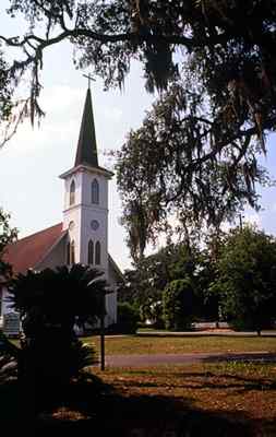
First Presbyterian Church, at Bayard Square and Jackson Street, was rebuilt in 1900 after a fire the previous year. This was the home of the first Presbyterian congregation in Georgia, making Darien the cradle of Presbyterianism in Georgia.
Oglethorpe Oak and Highlander Monument. Located at US 17 and GA 99 (Adams Street). The old oak, which shaded units of Oglethorpe's men, survived hurricanes, fires, and other calamities until it finally expired in the 1960s, leaving just a stump. The Highlander Monument was dedicated in 1936.
Vernon Square. On Washington Street. In the 1800s this square was the business, cultural, social, and religious center of Darien. The Methodist Church was originally built in 1843, partially damaged during the Civil War, then rebuilt in 1884 with many of the materials of the first church. St. Andrews Episcopal Church was the site of the famous Bank of Darien. The church was built in 1878. Open Gates, a bed and breakfast, was built in 1878 by sawmill owner Isaac Aiken. Hilton House, on south Vernon Square, was built by timber baron Joseph Hilton in 1875.
First African Baptist Church. Located at Madison and Market streets, this church was erected in 1868 as a replica of the 1834 church that once stood on this site.
St. Cyprian's Episcopal Church. Located at Fort King George Drive and Boone Dock Road. A tabby church built in 1876 by former slaves and serving a black congregation, this church was named for a martyred African saint.
Ashantilly and St. Andrew's Cemetery. Only 1 mile northeast on GA 99 from the courthouse is the mainland home of Sapelo Island's Thomas Spalding, built in 1820. St. Andrews Cemetery was established in 1818 as the Spalding family cemetery.
The Ridge National Historic District. Approximately 3 miles north of Darien on GA 99 are Victorian homes from the late 1800s that were owned by prosperous timber barons and bar pilots.
Valona. Located 10 miles north of Darien on GA 99, and 1 mile down a county road to the right is a traditional commercial fishing community that grew up along Shellbluff Creek in the 1890s.
Pine Harbor. Travel 3 miles north of Eulonia on US 17, then turn left on Pine Harbor Road, and go 3 miles to Pine Harbor. This was the site of the McIntosh family's Mallow Plantation. Today, historical markers and a family cemetery are found in the shade of live oak trees. The cemetery holds Captain William McIntosh, the father of the murdered Creek Indian chief.
Archie's Restaurant. US 17, Darien. There should be a historical marker outside this restaurant, a longtime favorite of locals and tourists alike since 1938. Archie Davis Sr. started the restaurant (in a different location in Darien) and Archie Jr. runs it today. The restaurant's famous slogan remains as true today as it did 60 years ago: "Seafood Served in this Restaurant Slept in the River Last Night." Archie's World Famous Fried Shrimp features three dozen sweet Georgia shrimp that, unlike most shrimp served in coastal restaurants, have not been raised in Ecuador, frozen, and thawed, then fried. Some say Archie's Altamaha River Fresh Water Catfish is even better, featuring delectable river catfish Archie buys from local fishermen. You decide. Breakfast, lunch, and dinner served. Closed Sundays. Moderate. (912) 437-4363.
Open Gates Bed and Breakfast. Vernon Square, Darien. This B&B is a great place to launch explorations of Darien and the rest of McIntosh County. Located on historic Vernon Square, Open Gates was built in 1876 by sawmill owner Isaac Means Aiken. Vernon Square was the heart of business, cultural, social, and religious activities in Darien. The square was laid out in 1806, then burned twice during the Civil War, and is today listed on the National Register of Historic Places. Open Gates is nestled in a beautiful setting of oaks and gardens, and has modern amenities, including air conditioning and a pool. Proprietor Carolyn Hodges is knowledgeable about the area's history and can arrange historic and nature tours. Moderate. (912) 437-6985.
Motels in McIntosh County. Several reliable chain motels are found near Interstate 95. Holiday Inn. Darien. Five minutes from Darien and local attractions is a relatively new Holiday Inn. Moderate. (912) 437-5373. Days Inn. Eulonia. Centrally located in McIntosh County just off the Interstate 95 at Exit 11/58, this motel offers a full-service restaurant and swimming pool. Children eat free. Moderate. (912) 832-4411.
Three privately run campgrounds are popular with travelers exploring the coast. Two are situated within 1 mile of Interstate 95: Lake Harmony RV Park and Darien Inland Harbor Campground. With their close proximity to the interstate, these are popular with travelers passing through the Georgia coast. A more low-country option, Belle Bluff Island Campground, is located on a tributary of the Sapelo River and is an excellent base for launching explorations of McIntosh County.
Belle Bluff Island Campground. Pine Harbor. Here you have access to a marina and charter fishing, along with RV and tent sites. The full-service marina has a boatlift, gas and oil, boat rentals, charters, bait and tackle, and a general store. A dock is used for crabbing and shrimping. The campground has tent sites and RV sites with full-hookups. Nature tours can be arranged through the office. Directions: from I-95, take Exit 11/58 and go 1 mile south to US 17, then turn left and go 2.25 miles to Pine Harbor Road. Turn right and go 2.5 miles to Belle Hammock Road, and turn left and go 1.25 miles to entrance of Belle Bluff Island. (912) 832-5323.
Lake Harmony RV Park. Townsend. Less than 1 mile west of I-95 off Exit 11/58, this campground offers a fishing lake along with 52 RV sites, full hookups, pull-through sites, tent sites, bait and tackle, laundry, swimming pool, and cable TV. (888) 767-7864.
Darien Inland Harbor Campground. Darien. Located east of I-95 off of Exit 10/49, Inland Harbor features RV sites, full hookups, pull-through sites, laundry, and bathhouse. (912) 437-6172.
 Fort
King George State Historic Site
Fort
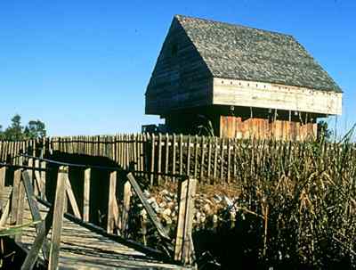
King George State Historic Site [Fig. 16(4)] Twelve years before Oglethorpe founded Savannah, the British built a fort and cypress blockhouse on a bluff of the Altamaha River in Darien to counteract Spanish and French expansion. Fort King George, constructed in 1721, was the first British settlement in what would become Georgia and the southernmost military outpost of the English Empire in North America until 1736, when Oglethorpe built Fort Frederica on St. Simons Island. Fort King George was abandoned in 1(912) 727, but its historic importance is recognized at Fort King George State Historic Site, which features an excellent authentic replica of the fort, along with a museum dedicated to the period. From the blockhouse, which stands 40 feet above the ground, the visitor is treated to a scenic panoramic view of the river delta and marsh islands. The beautiful natural setting of the grounds offers wildlife viewing and nature observation, while it evokes feelings of isolation that surely were experienced by soldiers posted at this remote frontier fort. The historic site has exhibits on other settlements, including a Guale Indian village, a sixteenth century Spanish mission called Santo Domingo de Talaje, and nineteenth century sawmills. Be advised that due to the marsh and freshwater pools on the site, insects can be bothersome without repellant.
English colonists from Charleston, South Carolina established the fort as a defensive measure. In 1720, John Barnwell, prominent planter in the Port Royal district, was sent to London to argue before the Board of Trade for funds and men to build a fort at the mouth of the Altamaha River. The French had control of Canada, the Gulf of Mexico, and the Mississippi River and were planning to colonize the Altamaha River, and the Spanish were well established in Florida. Barnwell's request was granted, and in 1721 he and Provincial Scouts built Fort King George, named for King George I. Situated on a peninsula below Altamaha Bluff called "low bluff," the fort was a triangular-shaped earthwork fortification, with the north branch of Altamaha River defending one side, and a palisaded moat on two other sides to defend against a landward attack. The fort's main structure was a 40-foot-high, 26-foot square blockhouse built from cypress cut from nearby wetlands. The gabled blockhouse had three stories: a powder, ammunition, and supply magazine on the first floor, a gun room with cannon ports for firing on the river on the second floor, and a lookout post on the third floor. Several other buildings, including a barracks, and officers' house, stood inside the earthworks. When the fort was originally built, it guarded the main channel of the Altamaha, but a navigational shortcut dug across a loop of the river in the mid-1800s caused the main currents to shift 1 mile from here, leaving behind the small tidal creek one sees today.
Life at the fort was a mixture of unrelieved boredom and suffering. Malnutrition and disease resulted in high mortality rates, with at least 140 British soldiers dying at the fort during its seven-year tenure. One year, more than two-thirds of the company died. Sixty-five British soldiers were buried in a nearby cemetery, which is believed to be one of the oldest British military cemeteries in the United States. The fort caught fire in 1725, damaging the blockhouse and destroying the barracks. The fort was partially rebuilt, but then in 1(912) 727, the fort was abandoned and the garrison moved to South Carolina. Two lookouts were left behind, possibly until Oglethorpe's arrival with a large group of Scottish Highlanders who were instructed to develop the settlement that came to be known as Darien.
 Near
the fort site was a Guale town called Talaje and later a Spanish mission
settlement called Santo Domingo de Talaje, established in 1595. It was
destroyed in the Guale Indian uprising of 1597. The Spanish returned and rebuilt,
but the mission was destroyed and abandoned for good in 1661.
Near
the fort site was a Guale town called Talaje and later a Spanish mission
settlement called Santo Domingo de Talaje, established in 1595. It was
destroyed in the Guale Indian uprising of 1597. The Spanish returned and rebuilt,
but the mission was destroyed and abandoned for good in 1661.
Fort King George was lost for some time until 1932, when it was rediscovered after searching colonial records. The Sea Island Company purchased the tract in 1926. In 1948, the property was deeded to the State of Georgia from Alfred W. (Bill) Jones Sr. of the Sea Island Company in order to build a state historic site. In 1967, a thorough archaeological investigation was undertaken. No trace of the blockhouse was found (many historians believe it was dismantled and shipped to another site), but the British cemetery and many other archeological findings convinced historians that this was the historic site, and it was placed on the National Register of Historic Places. In 1988, a joint venture between the Altamaha Historical Society and the Georgia Department of Natural Resources led to the faithful reconstruction of the fort, palisades, and breastworks based on old records and drawings found at the British Public Records Office. The new fort was built with the same materials and construction methods that were used in precolonial times. Ruins of three sawmills that operated on the site hark back to the nineteenth century, when Darien was a busy lumber exporting town and major seaport.
A short nature trail winds through brackish marsh and maritime forests composed of live oak, pine, red cedar, and baldcypress mixed with shrubs including groundsel, wax myrtle, and yaupon holly. Common wildlife seen in the marsh and freshwater ponds includes wading birds, clapper rails, snakes, and American alligators. Many songbirds have been identified at the site, such as prothonotary warblers, painted buntings, and Swainson's warbler in the summer, and yellow-throated and black-throated blue warblers in the winter.
Living history demonstrations occur annually at the fort, and large groups can arrange for special interpretive programs. The museum features exhibits and a film that cover the various historic periods of the site. Picnicking is available on the grounds in a small grove of Live Oaks and cedars.
Read and add comments about this page