Glynn County Area Attractions
Howfyl-Broadfield Plantation State Historic Site
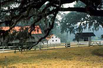
[Fig. 16(6)] Howfyl-Broadfield
is like a time machine: Visitors to this historic site are transported back
to the mid-1800s when rice plantations dominated tidewater Georgia. Maybe what's
important here is what you don't see: Tara, the grand plantation indelibly
etched in the popular mind from the movie Gone With The Wind. But it
could be argued what you do see is very interesting: a historic working
plantation with its original furnishings, complete with the freshwater marshes
and dikes that supported five generations of owners.
Located in the Altamaha River delta, the plantation site measures 1,268 acres
consisting of freshwater marsh, longleaf pine flatwoods, and farm pasture. The
natural setting, with huge Live Oaks
festooned with Spanish moss, provides a beautiful backdrop for a hike on a sunny
day. Three trails should satiate nature lovers, and expose them to vegetation
and wildlife typical of the Georgia coastal environment. The park is on the
Colonial Coast Birding Trail for its abundant bird life and easy access.
Two champion trees are found on the property, including a national champion
American holly (Ilex opaca) and state champion sweet-bay (Magnolia
virginiana). Two Live Oaks found
near the home are estimated to be over 300 years old and are as impressive as
can be found, and two magnolias are believed to be over 100 years old. More
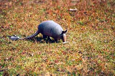
than 144 birds have been identified on the property, and the pasture openings
are good places to see deer, rabbits, and armadillos. Gray squirrels are the
most common animal at the historic site, eating acorns from Live
Oaks near the visitor center. Lucky observers may sight the endangered southern
fox squirrel, a large squirrel with a black face and paws and a blond tail.
Marsh rabbits and raccoons can be observed feeding in the marsh.
 The
plantation's beginnings trace back to 1807, when William Brailsford, a Charleston,
South Carolina merchant of English descent, began carving a rice plantation
out of the cypress swamps that bordered the Altamaha River. Brailsford's daughter,
Camilla, married James M. Troup, brother of Georgia Governor George Troup. James
Troup helped build the plantation into 7,300 acres of land, with 400 slaves
and several homes. When he died, the plantation passed into the hands of his
daughter Ophelia and her husband George Dent. In 1851, Dent built the plantation
home that is open to tour at the historic site.
The
plantation's beginnings trace back to 1807, when William Brailsford, a Charleston,
South Carolina merchant of English descent, began carving a rice plantation
out of the cypress swamps that bordered the Altamaha River. Brailsford's daughter,
Camilla, married James M. Troup, brother of Georgia Governor George Troup. James
Troup helped build the plantation into 7,300 acres of land, with 400 slaves
and several homes. When he died, the plantation passed into the hands of his
daughter Ophelia and her husband George Dent. In 1851, Dent built the plantation
home that is open to tour at the historic site.
The rice plantation was successful until the outbreak of the Civil War. George
Dent and his 15-year-old son James joined the Confederate Army, and Ophelia
and the rest of the family moved to a refugee settlement called Tebeauville
near the present city of Waycross. After the war, the Dents struggled to stay
financially afloat, giving up significant portions of their property. In the
1880s, the property was taken over by James, their oldest son, who was married
to Miriam Cohen. When James Dent died in 1913, the plantation was still in debt.
Miriam, who was an astute businesswoman, took over the plantation and with her
son Gratz converted it into a dairy farm around 1915. When she died, the plantation
was inherited by her daughters Ophelia and Miriam, who took over the duties
of running the farm. The dairy served Glynn and McIntosh county homes, delivering
100–150 bottles of milk daily. It was closed in 1942, when the sisters
had attained financial security, paying off the debt on the farm. Ophelia Troup
Dent lived on the plantation until her death in 1973 at the age of 86. In her
will, she left the farm to the State of Georgia to be preserved as a historic
site.
Comfortable walking shoes and insect repellant are necessary at this site. The
visitor center features a museum and a short slide show that explains the history
and significance of rice plantations on the Georgia coast. From here, the 1-mile
Plantation House Trail leads visitors through pasture to the plantation home
and complex of support buildings, then loops through a maritime forest, with
overlooks and observation decks, before returning to the visitor center. A tour
of the plantation home, built in 1851, is highly recommended. Notice the pay
shed, where farm workers were paid for their labors.
After leaving the house, the trail goes through forest adjacent to the rice
marsh. Here one can find the state champion sweet-bay in a drainage ditch next
to one of the footbridges on the trail, along with 100-year-old loblolly pines
of great girth, and other oaks, sweetgum, and Eastern red cedar. Indian pipe
(Montropa uniflora), a soprophyte that looks like a peace pipe, also
grows in the forest. Wild rice, growing to 9 feet tall, is found in wet places
in the marsh.
 The
second and third trails are located directly across from the historic site entrance
on US 17. The first is the 2.5-mile Maritime-Pineland Woods Loop Trail. Looping
off of it is the 0.5-mile Barrow-Pit Lake Loop Trail. The pinelands are especially
interesting, featuring a climax stand of longleaf pine (Pinus palustris),
which once dominated the Coastal Plain of the South. A fire-dependent ecosystem,
the climax forest's ground cover has been described as the most diverse outside
of the tropics. More than 90 species of plants have been identified in the pinelands'
ground cover, including common St. John's wort (Hypericum perforatum),
glaucous blueberry (Vaccinium darrowi), a variety of pawpaw species,
persimmon, rattlebox, and witch hazel. The maritime forest contains loblolly
pine, laurel oak, diamond-leaf oak (Quercus laurifolia), longleaf pine,
and live oak. The understory supports bays and oaks, along with sassafras, yaupon,
saw palmetto, and dwarf huckleberry. muscadine
grapevines are common, as well as greenbrier, catbrier, and yellow jessamine.
The
second and third trails are located directly across from the historic site entrance
on US 17. The first is the 2.5-mile Maritime-Pineland Woods Loop Trail. Looping
off of it is the 0.5-mile Barrow-Pit Lake Loop Trail. The pinelands are especially
interesting, featuring a climax stand of longleaf pine (Pinus palustris),
which once dominated the Coastal Plain of the South. A fire-dependent ecosystem,
the climax forest's ground cover has been described as the most diverse outside
of the tropics. More than 90 species of plants have been identified in the pinelands'
ground cover, including common St. John's wort (Hypericum perforatum),
glaucous blueberry (Vaccinium darrowi), a variety of pawpaw species,
persimmon, rattlebox, and witch hazel. The maritime forest contains loblolly
pine, laurel oak, diamond-leaf oak (Quercus laurifolia), longleaf pine,
and live oak. The understory supports bays and oaks, along with sassafras, yaupon,
saw palmetto, and dwarf huckleberry. muscadine
grapevines are common, as well as greenbrier, catbrier, and yellow jessamine.
The Borrow-Pit Lake Trail circles a lake created when dirt was "borrowed"
from the property to create a railroad bed. Vegetation around the lake consists
of oaks, pines, bays, and maples, along with gallberry, wax myrtle, dog fennel,
and dahoon. Several carnivorous plants, each with its own strategy for trapping
and digesting small organisms, are found in the lake and canal including round-leaved
sundew (Drosera rotundifolia), yellow butterwort (Pinguicula lutea),
and floating bladderwort (Utricularia inflata).
- Trails: 1-mile Plantation House Trail, 2.5-mile Maritime-Pineland
Woods Trail, and 0.5-mile Barrow-Pit Lake Loop Trail.
- Directions: I-95 south from Savannah to Exit 9/42. Go east on GA
99 approximately 1 mile to US 17. Turn left (north) on US 17 and drive 1 mile
to park entrance on right.
- Activities: Historical touring, picnicking, museum touring, hiking,
nature study. Call for special scheduled events.
- Facilities: Museum, AV theater, bookstore, picnic tables, restrooms,
playground.
- Dates: Closed Mondays except for federal holidays.
- Fees: A small fee is charged for park admission.
- Closest town: Darien.
- For more information: Hofwyl-Broadfield Plantation, 5556 US 17 North,
Brunswick, GA 31525. Phone (912) 264-7333.
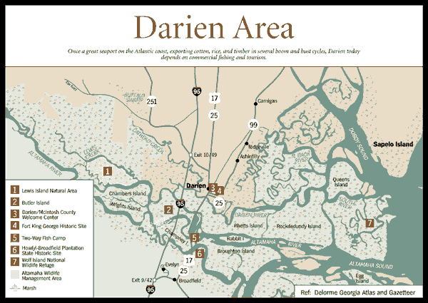
Two-Way Fish Camp
[Fig. 16(5)] One of
the more popular marinas on the coast is Two-Way Fish Camp, which allows boaters
to go, ahem, two ways: either upstream in the South Altamaha River or downstream
to Altamaha Sound and offshore waters. This is a great place to book a freshwater
or saltwater fishing trip or nature excursion. The marina hosts an annual fishing
rodeo in June and a trout-fishing event in the fall. Call for dates and details.
Two-Way is a full-service marina, with gas and diesel, supply store, hoist,
bait and tackle, guides and charters, dry and wet storage, and engine repair.
Located on a short spur off of US 17 at the South Altamaha River. (912) 265-0410.
Mudcat Charlies at Two-Way Fish Camp. US 17 North
at the South Altamaha River. This reasonably priced, relatively new seafood
restaurant has the advantage of overlooking the glorious southern channel of
the Altamaha River. Just steps away from the boats are offerings of shrimp,
scallops, and oysters prepared fried, broiled, or buffaloed. Boiled blue
crab and "mudcat wings" are other popular orders. And it's the
only restaurant serving a Fanny Kemble
After Dinner Drink. I wonder what she would have thought of the NASCAR
decorations. Open for lunch and dinner, 7 days a week, 11 a.m.–10 p.m.
Moderate. (912) 261-0055.
Glynn County Wildlife Management Areas
Paulks Pasture Wildlife Management Area
[Fig. 18(3)] With 17,000
acres of swamps and pine flatwoods in Glynn County, Paulks Pasture offers a
large area to hunt and explore. Hunters stalk deer, turkey, dove, furbearers,
and small game near Buffalo Swamp, which serves as headwaters to the Buffalo
River, a tributary of the Turtle River. The swamp and river receive their name
from the scarcely known fact that buffalo used to live in the southern river
swamps in pre-Columbian times, and were hunted by Indians. Hikers should visit
the area when it is not hunting season. Campers should check with the regional
office concerning regulations.
- Directions: From Brunswick, go north for 8 miles on US 341. Check
station on left.
- For more information: Wildlife Resources Division, Georgia Department
of Natural Resources, Brunswick, GA 31520. Phone (912) 262-3173.
Rayonier Wildlife Management Area
[Fig. 18(2)] Located across
the Glynn County line in Wayne and Brantley counties is the 12,687-acre Rayonier
Wildlife Management Area, used primarily by hunters during hunting season. Most
of the tract consists of the Penholoway Bay Swamp, bottomland forest, and pine
flatwoods, which serve as the headwaters of Penholoway Creek that flows north
in an arc before turning south to the Altamaha River. Deer and turkey are the
primary prey, along with furbearers and small game.
- Directions: From Brunswick, go north on US 341 to Sterling. Turn
left on GA 99 and go approximately 3 miles to GA 32. Turn right and go approximately
20 miles to Fendig and turn right on Fendig Road.
- For more information: Wildlife Resources Division, Georgia Department
of Natural Resources, Brunswick, GA 31520. Phone (912) 262-3173.
Sansavilla Wildlife Management Area
[Fig. 18(1)] Bordering the
Altamaha River, this 17,814-acre wildlife management area straddling the Glynn-Wayne
county line is popular for hunting deer, turkey, raccoon, and opossum, as well
as launching boats into the Altamaha River from Lower Sansavilla Landing for
fishing and wilderness excursions. Sansavilla derives its name from an Indian
town, Santa Savilla, which existed on the 4-mile-long bluff overlooking the
Altamaha River at the mouth of Alex Creek. The southern end of the bluff, which
looks across to Fort Barrington, was visited by naturalist William Bartram during
his travels in Georgia in the eighteenth century. Those wishing to explore the
area should visit when it is not hunting season. Camping is permitted, but check
with regional office first.
- Directions: From Brunswick, go north on US 341 toward Jesup for 20
miles to Mount Pleasant. Turn right and cross railroad tracks into area. Follow
power lines to Lower Sansavilla Landing.
- For more information: Wildlife Resources Division, Georgia Department
of Natural Resources, Brunswick, GA 31520. Phone (912) 262-3173.
Earth Day Nature Trail, Coastal Resources Division, Georgia
Department of Natural Resources
[Fig. 18(4)] Glimmering
in the marsh north of the Sidney
Lanier Bridge is the Georgia Department of Natural Resources headquarters.
Next to the building is an interpretive nature trail that provides a good basic
introduction to the flora and fauna of Georgia's marsh ecosystem. Inside the
building are aquariums with native marine fauna.
Called the Earth Day Nature Trail, it features two short looping trails that
wind through maritime forest, complete with benches, boardwalks, interpretive
signs, observation towers, and platforms. The trail provides an easy way to
examine the plants and animals of the salt marsh, freshwater pond, and sandflat
habitats.
On the trails, hikers will learn about sugarberry, mulberry, cabbage palm, and
Eastern red cedar trees of the coast. An observation platform at the end of
one spur provides access to an osprey nest. Sea oxeye, wax myrtle, and prickly
pear cactus are three common plants one sees on the trail. Marsh rabbits are
often glimpsed in the more wooded areas, and many wading birds are common residents
such as egrets, herons, ibis, willets, and sometimes wood storks. Secretive
clapper rails can be heard making their distinctive call. Periwinkles, mud snails,
and ribbed mussels are very common mollusks seen slowly feeding in the Spartina
marsh. Mud fiddlers and sand fiddler crabs are observed in habitats they're
named after.
The Coastal Resources Division, Georgia Department of Natural Resources is the
state agency charged with the responsibility of protecting the coast's natural
resources, and it is appropriate that its headquarters is situated in the golden
marsh. Inside the headquarters are restrooms and aquariums, and information
on many coastal activities.
- Trails: 0.5-mile Earth Day Nature Trail.
- Directions: From Brunswick go south on US 17 past Brunswick city
limits. North of the Sidney Lanier
Bridge, turn left on Conservation Way. Follow sign to DNR Coastal Regional
Headquarters. At northeast end of the parking lot is a sign and entrance to
the trail.
- Activities: Nature hiking and study, picnicking. Coastfest, the Department
of Natural Resources' annual celebration of coastal natural resources, is
held the first Saturday of October.
- Facilities: Observation shelters, interpretive programs, aquarium
display, orientation shelter, restrooms, drinking water, and binoculars available
for checkout at headquarters.
- Dates: Trail open daily. Headquarters open 8 a.m.–4:30 p.m.,
Monday through Friday.
- Fees: None.
- Closest town: Brunswick.
- For more information: Coastal Resources Division, Georgia Department
of Natural Resources, 1 Conservation Way, Brunswick, GA 31520. www.ganet.org/dnr/coastal
Phone (912) 264-7218.
Read
and add comments about this page
Reader-Contributed Links to the Georgia Coast and Okefenokee Book: