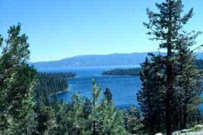
The Lake Tahoe Basin has been a recreational gathering place for many decades this century because millions of people are attracted to Lake Tahoe, one of the larger, clearer, high-elevation lakes in the world. People come here to hike, boat, camp, gamble, bicycle, and take photographs. Lake Tahoe and Yosemite National Park are the busiest outdoor recreation places in California, but Tahoe offers something Yosemite does not: Nevada casinos.
Lake Tahoe is at the California/Nevada state line. A visitor can spend time at a large Nevada casino where gambling and entertainment continue round-the-clock. Yet, within minutes, the same visitor can walk a mile to a spot near the lake and see an osprey (Pandiion haliaetus) fighting a Cooper's hawk (Accipiter cooperi) over a salmon.
 Speedboats
zoom along this 22-mile-long lake. Hikers and bicyclers navigate the 71
miles of shoreline—42 in California, 29 in Nevada. Parasails and hot-air
balloons float across the sky. Motels crowd the shoreline.
Speedboats
zoom along this 22-mile-long lake. Hikers and bicyclers navigate the 71
miles of shoreline—42 in California, 29 in Nevada. Parasails and hot-air
balloons float across the sky. Motels crowd the shoreline.
Behind the recreational glitter, a deep geologic and cultural history surround this 122.1 million acre-foot lake. Though the lake's basin is adjacent to the Eldorado, Tahoe, and Toiyabe national forests, scientists consider it separate from other parts of the mountain range, for good reason.
For one thing, it is a pretty rare breed. Sixty-three streams flow into Lake Tahoe, but only one, the Truckee River, flows out past Reno and into Pyramid Lake. Tahoe's water never flows into the Pacific Ocean.
Tahoe's huge, natural collection of water dwarfs even the biggest human-made reservoirs in California. The water that evaporates from the lake every 24 hours could supply the city of Los Angeles for a day. At about 1,645 feet deep and 193 square miles, it is obvious that Lake Tahoe is not a body of water that would fit neatly into one administrative forest—or even one state. That's why the federal government set up the Lake Tahoe Basin Management Unit, rather than include it in a national forest.
The government clears up all kinds of misconceptions about the lake. Perhaps the biggest misunderstanding involves the lake's origins. Some people mistakenly believe the lake was formed by the collapse of a volcanic crater. Actually, plate tectonics had more to do with it in the beginning. The basin was formed 5 million to 10 million years ago when the Sierra crest began to lift on the west and the Carson Range did likewise to the east.
Volcanic eruptions entered the picture later. About 2 million years ago, an andesite lava flow from the north shore of Mount Pluto formed a barrier across the basin's northeastern outlet. Eventually, as the lake rose, the Truckee River was able to cut through these flows and flow around the volcanics to the lowlands of Nevada.
Glaciers downstream of the lake also dammed it between 20,000 years ago and 2 million years ago, causing the lake level to fluctuate as glacial periods came and went. At one point, the lake was almost 800 feet higher than its present level. Large sedimentary terraces perched above the lake remain as evidence of the old shore much closer to the natural rim.
It is believed that long-term drought—which has occurred periodically over the last several thousand years—is responsible for the lowering of the lake even farther below the current shoreline than it is today. Researchers have found tree stumps as deep as 16 feet below the surface of the current south shoreline and 40 feet deep along the east shore. The trees were about a century old when they died. A lake reduction of that magnitude in the last several thousand years suggests stream changes, wetland modifications, and a host of erosion and sediment problems that would have impacted the area.
Further back in time, three major periods of glaciation occurred in this part of the Sierra during the last Ice Age, which ended 10,000 years ago. Rather than featuring the regional "ice sheets" that covered much of North America, the Ice Age manifested itself as individual glaciers forming at the highest elevations. These glaciers carved out individual valleys during their downward movement. Emerald Bay on Lake Tahoe and nearby Fallen Leaf Lake have the elongated shapes characteristic of glacial valleys.
The ice dams across the Truckee River canyon floated several times and broke apart, releasing walls of water that carried immense boulders downstream, now found along the Truckee River canyon and in the Reno area. These floods also carved through the glaciers surrounding Truckee and eroded channels through their glacial debris.
Similar events took place around the lake; many are described in signs around the lake. The signs say Tahoe, at 6,225 feet in elevation above sea level, is the 3rd deepest lake in North America and 10th deepest in the world. The lake bottom is actually 92 feet below the level of Carson City, Nevada, to the east. Scientists estimate it would take 700 years to refill if it somehow emptied into the Pacific.
The tributaries deliver about 300,000 acre-feet of water to the lake annually to keep it deep and cold. Because of the lake's depth and circulation, it does not freeze. However, portions of Emerald Bay on the southwest shore have been covered with ice. Temperatures tend to stratify in the lake, with the shallower portions reaching temperatures as high as 68 degrees Fahrenheit. Below 600 feet, however, the water remains a fairly constant 39 degrees Fahrenheit.
The pristine mountains surrounding this high-elevation lake are filled with flora and fauna that have been studied for many years. Like the rest of California, the big swings in temperatures, precipitation, and terrain make it a place filled with endemics—plants that are found nowhere else on earth. Among them are the clarkias, sunflower family members, and buckwheats.
The animals include the black bear (Ursus americanus), which can grow to 500 pounds. Migrating birds, small terrestrial scavengers, and many types of fish are found around the lake. One interesting fish is the kokanee salmon, which does not migrate to the ocean and then return to fresh water to spawn. The kokanee instead spawns in surrounding streams and lives its life in Lake Tahoe's clear water.
The lake's water is known for being clear because of the high Sierra streams that empty snowmelt into it. In many places, people can see down 75 feet. But Lake Tahoe is in the process of filling up with sediments washed into it from slopes that are being cleared for construction. Each sediment particle carries nutrients that stimulate algae growth and could eventually ruin the famous clarity of the lake.
This is where the human activity and the ecosystem clash. Federal government scientists continue to study human impacts on water and air quality, and the delicate natural balances that keep Tahoe healthy. For instance, ozone, the invisible gas created in summer when chemical emissions from cars mix with sunlight, is actually being carried into the lake area through atmospheric winds from other parts of California.
The basin has long been considered a place where contaminants, smoke, and airborne matter could accumulate, even from limited sources. Smoke from natural lightning fires and fires set by the Washoe people occurred at the lake in historic times. The smoke is believed to have played an important role in limiting outbreaks of insect pests in the forest. The wood smoke, however, is not nearly as bad as emissions from automobile engines and other sources.
Until about the last half century, Lake Tahoe was quite a different place for people. Humans have been part of the ecosystem for about 8,000 years.
Centuries before explorers John Fremont and Kit Carson discovered Lake Tahoe in 1844, the Lake Tahoe Basin was a summer gathering place for three bands of peaceful Washoe Indians. Scientists believe the Washoe inhabited the area as long as 1,300 years ago. The lake held a spiritual meaning for the tribe and many sacred ceremonies were held along the southern shores.
The Indians hunted, fished, and gathered in this elegant ecosystem. Burning, weeding, and selective harvest were part of their manipulation of the ecosystem. Pinion pine (Pinus monophylla) and acorns from various trees provided winter staple foods.
But by the end of 1862, the tribe lost all its lands due to encroachment from European settlers. The California Gold Rush lured emigrants and fortune seekers to the rugged Sierra. Prospective miners used passes to the north and south to circumnavigate the Tahoe Basin.
The first west-to-east road across the mountains, the "Bonanza Road," was built to handle travelers eager to cash in on Virginia City's massive Comstock Lode, which was discovered in 1859. Highway 50 now covers this route. Way stations, stables, and tollhouses sprang up along the route. These stations were the basis for most development in the area, from Friday's Station at Stateline, which served as a Pony Express stop, to Yank's Resort in Meyers, which was built in 1851.
The discovery of the Comstock Lode not only increased traffic, but it also inflated the use of the Tahoe Basin's natural resources to a dangerous level. Wood was needed for fuel and to support the labyrinth of mines being constructed beneath Virginia City.
Between 1860 and 1890, two-thirds of Tahoe's forests were stripped of trees. During peak years, 72 million board-feet of lumber were milled. The Carson and Tahoe Lumber and Fluming Company produced 750 million board-feet and 500,000 cords of firewood between 1873 and 1898. And there were three other major companies. The decline of the Comstock Lode may have been the saving of the Tahoe forest.
About the time the Comstock mines opened in the late 1850s, the commercial fishing industry discovered the world-class trout fisheries at Lake Tahoe. Within a few years, San Francisco, New York, Chicago, and other cities were importing Lake Tahoe trout. In 1880, state records show commercial fishing took 70,000 pounds of the native cutthroat or black-spotted trout (Oncorhynchus clarki). Commercial fishing was banned in 1917, just before the native trout population was fished out of existence.
Grazing also took place in the Comstock era. With commercial hay production reaching 800 tons each year, thousands of head of livestock were driven through the Lake Tahoe Basin to Virginia City where they were sold. Sheep were grazed for four decades after the Comstock era.
Washoe elders, who continue to gather basket materials and medicinal plants, say the sheep grazing probably destroyed the last of many important plant resources in the area. In some areas, the ubiquitous sheep grazing consumed every last shrub and patch of grass. Herders also burned many large, downed trees that they considered an obstruction. The large trees were key parts of the ecosystem, providing shelter and nutrition for insects and small animals.
Other attempts were made to control the ecosystem as well. In the late 1800s, dams were built on streams in the basin and water was diverted to Echo and Marlette lakes. The water was used for a variety of purposes, including irrigation.
At one point, U.S. Senator Francis G. Newlands pursued construction of a new dam at Lake Tahoe's outlet along the northern shore to ensure a constant water supply into Nevada for irrigation. His efforts resulted in the landmark Federal Reclamation Act of 1902, the law of the land in this century for parcelling water among users on federal projects. The Newlands Project—the dam at Tahoe's outlet to provide irrigation water for Nevada—remains the largest single appropriator of water from the Lake Tahoe Basin.
But the conservation backlash began almost at the start of the drain on Tahoe resources. The scenic qualities of Tahoe were not lost on the San Francisco newspapers, which reported the area's recreation potential as early as 1859.
A young Mark Twain wrote in 1861 of the beauty he saw at Tahoe: "As I lay there with shadows of the mountains brilliantly photographed upon its still surface, I thought it must surely be the fairest picture the whole earth affords."
These reports of Lake Tahoe's beauty did not go unnoticed by the wealthy families of San Francisco. By the turn of the century, the lake had become a haven for the well-to-do. Popular hotels of the era included the Tallac House, Tahoe Tavern, and the Glenbrook Inn. This period marked the heyday of steamship transportation around the lake, with boats providing mail and supply delivery and lavish transport for visitors.
In 1900, the Lake Tahoe Railway opened between Truckee and Tahoe City on the west shore, allowing wealthy San Franciscans to make the trip in nine hours. This melding of tourism and a wilderness ethic was established and carried through the twentieth century.
During the '20s and '30s, the roads through the mountains were paved, bringing in greater numbers of people and sparking growth of smaller, middle-class lodges. Development at Lake Tahoe began in earnest in the 1950s. Roads to the basin began to be plowed year-round, enabling permanent residence.
The growth took off with the emergence of the private automobile, the booming post World War II population, and the growing middle class. Casinos, conveniently located just across the state line in Nevada, were an added attraction. In 1944, Harvey Gross started the casino trend by opening Harvey's Wagon Wheel Restaurant and Casino. Others followed. By 1955, William Harrah purchased the Gateway Club and opened Harrah's hotel and casino. Two years later, in 1957, he expanded from a summer-only business to year-round.
The 1960 Winter Olympics at Squaw Valley put Lake Tahoe firmly on the map as the skiing center of the western United States. In 1968, growing environmental concerns caused California and Nevada to form the Tahoe Regional Planning Agency to oversee environmentally responsible development in the basin. Work began on a master plan designed to improve the local tourism industry while protecting the fragile environment on which it is based.
Tourism has developed into a $1 billion-a-year industry at Lake Tahoe. On peak holidays, more than 200,000 people visit the basin. An estimated 15 million people see Tahoe each year.
The late twentieth century urbanization of Tahoe and the crush of visitors have prompted the Washoe people to focus on re-establishing a presence in the basin. The tribe's influence had slowly diminished after 1950. Now, the Indians have become vocal stakeholders in the process of protecting the Lake Tahoe Basin.
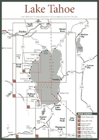
There are generally four sections of the Lake Tahoe Basin—North, West, South, and East shores. This chapter intentionally omits most of the East Shore because that side of Lake Tahoe is in Nevada. Also, the mountains on the Nevada side are generally the Carson Range, which is separate and distinct from the Sierra Nevada.
Read and add comments about this page