 Toiyabe
National Forest Toiyabe
National Forest
Toiyabe
National Forest Toiyabe
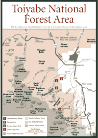
National Forest [Fig. 25] A glance at the size of the Toiyabe National Forest, established in 1964, makes one wonder if it is not the dominant natural area in the Sierra Nevada. The forest is 4.3 million acres, making it the largest national forest in the contiguous 48 states. But most of Toiyabe's acreage is in Nevada or along the California/Nevada line, outside the Sierra geological province.
Still, the forest offers spectacular hiking, wildlife viewing, and camping on the Sierra's stark east escarpment. The 48,000-acre Hoover Wilderness contains glacial lakes that have been stocked with trout. Yosemite National Park is just west of the wilderness. Hikers can easily go from Hoover Wilderness to one of the 10,000- or 11,000-foot passes into the park.
When crossing the crest of the Sierra on Highway 108, through Sonora Pass, motorists will watch the lush alpine vegetation switch over in a matter of minutes to the high desert vegetation that is characteristic of the arid east side. Anyone traveling through Sonora Pass or any of the other high Sierra passes should remember that the roads are usually closed in winter under heavy snowfall.
Volcanic features are also a part of the landscape on the east side. Aside from the views, volcanic activity leaves the residual benefit of hot springs. There are many on the east side, and Grover Hot Springs State Park is one of the more popular ones.
[Fig. 21(4)] A dip in mineral water at 102 degrees Fahrenheit is probably the best reason to visit Grover Hot Springs State Park, especially in the late fall or early winter. The biggest season is August, because that's when the tourist season is in full swing. But the cooler off-season is among the best times to visit.
Just be sure to check the weather report before going to Grover. Weather in the Sierra—or any high mountain range—is always worthy of watching and respecting because it can change so quickly. On the arid eastern side of the Sierra, weather is especially capricious.
Pristine, clear, warm days can be followed by cold, stormy nights. The eastern crest of the Sierra is a drier version of the west slope because of its steep slope, with a relatively gentle upslope on the west compared to the sudden and almost severe drop on the east side. Storms tend to drop a lot of precipitation on the west side, lose moisture before they get to the east side, and still pack a lot of wind energy. Thunderstorms are especially violent on the east side of the Sierra in August.
At Grover Hot Springs, which is at the edge of the Great Basin Province, the open pine forest and sagebrush belt are pummeled by everything from major blizzards to violent thunderstorms to dry, scorching winds. Winter temperatures can drop to minus 5 degrees Fahrenheit, and summer temperatures can climb up to 95 degrees.
The two pools at Grover Hot Springs will close during major thunderstorms whenever lightning strikes come within 1 mile (about five seconds between the sighting and the thunder). The thunderstorm season reaches its height in July and August. The weather supports pinion-juniper woodland, mixed with a coniferous forest. But the park's most interesting characteristic is Great Basin sagebrush (Artemesia tridentata). The smell of sagebrush in the eastside woodland is noticeable, especially in spring. Many miles down the road from mountain passes, people can smell this aromatic shrub.
It is the dominant plant over hundreds of miles on the eastern Sierra. It is home and protection to many kinds of insects and small animals. Many trails around the park will lead visitors to vast acreages of this ecosystem. It can be found in well-drained soils on outwashes, alluvial fans, and upland flats.
The sagebrush can be seen around the Grover Hot Springs area, along with wildlife such as deer mouse (Peromyscus truei), black-tailed jackrabbit (Lepus californicus), and sagebrush chipmunk (Eutamias minimus). But sagebrush and wildlife are not the main attractions for most visitors at the 700-acre Grover park. More than 100,000 people visited this place each year in the mid-1990s, and most were here for a dip in the pools. To achieve a comfortable temperature, state authorities combine cold water with the 148-degree stream, heated by the magma hundreds of feet below the ground level. The temperature in the hot pool runs between 102 and 104 degrees year-round, even in snowstorms.
The hot springs were formed thousands of years ago when a fault below ground level moved and diverted an underground stream through a heated, magmatic area. Many kinds of minerals, such as salt and calcium carbonate, are dissolved in the water at the higher temperatures. This spring is relatively low in sulfur content, so it does not have a powerful odor.
One of the more common questions about the hot springs is, "Why do they look green?" The main reason is the oxidation between the mineral salts and the sanitizing agent (Bromine) used in the pool. Viewed from a distance, the light tends to fall in the yellow and green parts of the spectrum.
[Fig. 25(1)] Many people enjoy visiting a working Western cattle ranch. At the Hunewill Guest Ranch, near Bridgeport at 6,500 feet on the eastern Sierra, visitors learn cowboy skills and share the workload involved in caring for 1,200 head of cattle. Visitors here often gather and sort cattle for vaccinating or branding.
Special events are scheduled to challenge the more advanced horse riders. Visitors learn to rope, part out a cow, track a cow and not get lost, and explore "cow logic." There's also a 60-mile cattle drive to move the herd into the Nevada acreage each fall.
Activities include talent night, family dance night, barbecues on the creek, or watching as young foals and yearlings are nurtured. There is world-class trout fishing in the nearby East Walker River and in the many lakes and streams in the adjacent Toiyabe National Forest.
The ranch was founded in 1861 by Napoleon Bonaparte Hunewill and his wife, Esther. In the 1930s, LeNore and Stanley Hunewill started the Hunewill Guest Ranch. Hunewill Ranch is still a working cattle ranch with 1,200 cows and 120 horses, as well as 60 sheep, 35 llamas, and 4 pigs.
[Fig. 25] With 48,000 acres of wild and rugged high Sierra between the elevations of 7,000 and 12,000 feet, the Hoover Wilderness is a favorite place for backpackers and day hikers. Long hikes can be taken at any time of the year, but the best time to travel in this wilderness is July through September. Though rain, blizzards, extreme cold, and strong winds can occur in any season, the summer months are the mildest.
Firewood is scarce, and no wood fires are permitted in 20 Lakes Basin, which is among the most heavily used areas. For those who want solitude, the least used area is in the northern part of the wilderness.
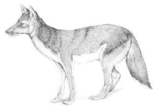
Wildlife viewing is one of the big reasons to hike this wilderness. Of the thousands of places in the Sierra to see mule deer (Odocoileus hemionus), this is probably one of the best because it is so remote. But the deer are adept at hiding themselves in brush, so hikers must be very patient and vigilant to catch a glimpse.
For birders, the soaring red-tailed hawk (Buteo jamaicensis) is common in this and other parts of the Toiyabe National Forest. This hawk's binocular vision allows it to find mice, rabbits, and ground squirrels to eat. These hawks have been known to attack rattlesnakes when other prey is not available.
In this part of the Sierra, campers may also encounter the California black bear (Ursus americanus), which can grow to 300 pounds and eat everything in ice chests for miles. Though they are called black bears, they are often cinnamon brown in the Sierra. They are omnivores, eating vegetation, honey bees, fish, small mammals, birds, and, unfortunately for campers, anything remotely smelling like food in ice chests, garbage cans, and cars.
Visitors can easily scare off bears by banging pots and pans, yelling, or blowing whistles. They are not usually dangerous or aggressive, though there is always a danger when a mother bear and her cubs are in the area. The mother bear could misinterpret any movement as a threat to her cubs and defend them. This is a very rare situation and injuries from bears or bear attacks are uncommon in the Sierra.
The Hoover's many backcountry locations are an advantage, because black bears in the backcountry do not have as many opportunities to raid camps as those in busy places such as Yosemite National Park to the west. They simply do not learn to become as bold as bears in busier places. Usually, campers can hang their food from a tree limb about 20 feet high and thwart any nighttime bear raids.
Campers should be warned, however: Do not keep food in the tent with you. Bears have entered tents for food. Do not leave the food in the car where a bear might see it or smell it. Bears can easily peel a window or door off the car for something as small as a gum wrapper.
Campers need to obtain permits in the Hoover Wilderness, but day hikers do not need a permit. The wilderness is on a quota system, which allows only a certain number of backpackers and overnight visitors to camp each day. The exact number changes from year to year. The quota system has been adopted because summer crowds were beginning to damage meadows, trails, and other features in the wilderness.
[Fig. 25(2)] The trail follows Buckeye Creek up a canyon that leads to splendid wildflower displays in June and July. Alder and fir trees mix near mountain meadows with paintbrush (Castilleia pinetorium) and lupine (Lupinus). Be prepared to hike most of the day. As the trail climbs, there are increasing numbers of aspen (Populus tremuloides) whose leaves will turn to gold in autumn. Even higher, granite peaks are visible as hikers come to the sign marking "Buckeye Trail," which indicates the boundary of the proposed addition to the Hoover Wilderness. The trail crosses three very small creeks as it climbs a bit then drops down to a wash.
There is no way to cross Buckeye Creek without getting wet. In September, it's shallow and easy to wade, but it could be a difficult crossing earlier when the creek is higher. Climbing along the west side of the canyon, hikers will see evidence of major washouts from snowmelt runoffs in recent years. Rock, dirt, and water came down the mountainside. Take this trail slow and easy. The trail will take hikers into the Hoover to Buckeye Forks.
[Fig. 25(3)] The trail is accessible to stock animals in addition to hikers, and both Tamarack Lake and the pond about 1 mile below it are nice spots to go for some trout fishing. On the way to the lake, look for wildlife including deer, lizards, and birds. Fall is a prime time to observe raptors, especially red-tailed hawks (Buteo jamaicensis), and possibly bald eagles (Haliaetus leucocephalus) and golden eagles (Aquila chrysaetos) around Twin Lakes.
Be sure to bring plenty of water (at least two quarts), as the trail is exposed to the sun for most of the way, and climbs steeply. From the trailhead, climb a steep grade to the northeast up to a bench, where the trail doubles back to the southeast. There are good camping spots on this bench. The trail switchbacks up over another bench, then to the top of the moraine. There are good views of Twin Lakes on the way up. On top is Upper Summers Meadows.
The trail follows along the top of the moraine south for about 0.25 mile, then meets and crosses the creek. It then begins to climb pretty steeply again southward past aspens (Populus tremoloides), sage (Salvia columbariae), and bitterbrush (Purshia tridentata) into a dry, open, alpine environment.
Scattered around the creeks are some pines and juniper mixed among the aspens. After crossing the creek and beginning to climb, the trail turns into a gravel/sand mixture, still easily discernible. Not more than 1.5 miles after topping out, there is an easy 1-mile walk through trees, across the creek, along the south side of a grassy meadow, up through more trees, and finally across a dry alpine meadow to Tamarack Lake.
There are lots of camping spots to the north and west sides of the lake. Tamarack Lake is shallow but pretty, bounded on two sides by Monument Ridge, and on the third by Crater Crest. The ridges hold several small snowfields, and just about a 1-mile scramble up to Hunewill Lake brings you to the base of some of them.
 Green
Creek Trail
Green
Creek Trail [Fig. 25(4)] The trail leads to Hoover Lakes, and the hike is exceptional because it contains so much of the East Sierra's stark beauty. It begins at Green Creek Campground, which is equipped with a toilet, garbage can, and running water—not a bad combination to find at 8,000 feet in elevation.
This is a good two-day hike because of the lakes along the way. Green Lake, East Lake, and Gilman Lake provide wonderful stops along the way. Campsites can be found in most areas.
Read and add comments about this page