 North
Shore North
Shore
North
Shore North
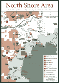
Shore [Fig. 27] The North Shore of Lake Tahoe extends from Tahoe City to the Lake Tahoe Nevada State Park—from California into Nevada. Some people also like to include the Truckee and Squaw Valley/Alpine Meadows areas to the west.
The North Shore seems a bit less busy than the South Shore, where historic sites, recreation, and casinos come together. But the North Shore has plenty of visitors.
Campgrounds, beaches, fishing holes, ski areas, and other facilities are used by thousands of people every year. Beaches are particularly popular. There are a half dozen within just a couple of miles around the Kings Beach State Park.
Fishing and boating are big attractions. A number of fishing guides, charter companies, and boating schools can be found on the North Shore.
All around the North Shore are views of ancient volcanoes, which helped dam the lake to create it. Andesite ridges of volcanic origin mingle with the granite of the Sierra. The volcanics and soils support many kinds of trees and brush along with brilliant wildflower shows.
Probably the most important volcano in the area is Mount Pluto, which was among the many volcanoes that erupted 25 millions years ago. Pluto ejected the lava plug that dammed Lake Tahoe. Mount Rose, on the Nevada side, is another example of a volcano that arose during the Miocene as the Pacific and North American tectonic plates collided. As with many other volcanic episodes in the Sierra and elsewhere in the world, geologists believe the collision of the tectonic plates caused magmatic unrest that resulted in the volcanics.
[Fig. 27(1)] This is the place to bring the children. The Kings Beach State Recreation Area has picnic tables, restrooms, and barbecues. Children enjoy the calm, shallow water. It is a safe place where families can recreate, but there is an entrance fee.
Kings Beach is not the only game in town for the North Shore, however. And other beaches have no entry fees, though they often do not have the facilities of the Kings Beach. The free beaches include National Avenue Beach, Moondunes Beach, Agatam Beach, and Secline Beach. They are all within about a mile of Kings Beach on the North Shore.
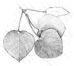
For those who are curious about all those trees just beyond the beach, tree identification is pretty simple matter around Kings Beach. The Jeffrey pine (Pinus jeffreyi) and the ponderosa pine or yellow pine (Pinus ponderosa) are common here.
Along the 700 feet of lake frontage at Kings Beach, the ponderosa pine displays a lighter or more pale color on mature trees, unlike any other conifer. The ponderosa pine was logged extensively and used in building materials. The fine, straight-grained wood is abundant in resin. This impressive tree can grow 200 feet tall in some areas, with a trunk width up to 8 feet. The bark on mature trees can be up to 4 inches thick, so this tree can withstand many forest fires.
In this area of the North Shore, giant hyssop (Agastache urticifolia) was used by Native Americans to make strong tea. The hyssop can still be seen today at the lower elevations around Kings Beach. The aromatic flower blooms in late June and July in clusters of spikes.
Four major stables operate in the North Shore area, including Tahoe Donner Equestrian Center, Northstar Stables, Squaw Valley Stables, and Alpine Meadows Stables. Each offers an array of rides. Tahoe Donner, for instance, has a "Horsemanship Camp" in which children learn equestrian skills.
Squaw Valley has one-, two-, and three-hour rides that leave on an hourly schedule. At Alpine Meadows, 5-year-olds are allowed on the rides. Most stables are closed for winter, but Northstar Stables offers sleigh rides when the snow flies.
 Fishing,
Boating
Fishing,
BoatingEven for seasoned fishing enthusiasts, Lake Tahoe is an immense challenge. The deep-dwelling brown trout (Salmo trutta) and lake or Mackinaw trout (Salvelinus namaycush) can be trophy-sized, but it saves time to know where to fish.
Fishing is one of the big reasons people come to the North Shore. Many charter companies make it easier to find the best fishing areas. Boating and camping can often be part of a fishing trip to the North Shore, though they are certainly separate activities for many people.
For fishing enthusiasts, the kokanee salmon (Oncorhynchus nerka) can be an interesting and game catch. The silver and a bluish-black fish normally has a green head. It has three layers of muscle—white, pink, and red or lateral muscle. The lateral muscle is found along sides, just under skin. It has high fat content used in steady, untiring swimming activity during migration from a lake to a fresh water stream nearby in September and October. Kokanee salmon require clean sand and gravel beds in streams to spawn, and the North Shore and the rest of Tahoe can provide those.
To fish for the kokanee or other Tahoe fishes, many visitors opt for the help of professionals. Fishing charter companies supply tackle and one-day licenses where they are needed. Any person, 16 years of age or older, must have a California or Nevada sport-fishing license to fish in Lake Tahoe. Surrounding lakes and streams require a license for the state in which the person is fishing.
After the fishing license, people need to know where they can find the best fishing—whether it's in the lake or in a nearby stream. That's where the charter fishing companies or guides come in. What other advice would they have? One example would be to avoid fishing during times of mirror-like calm, unless fishing deep for Mackinaw. Even a slight surface riffle will break up shadows cast on the bottom and will partially obliterate the angler from view.
There are many charter companies; here are a few: Kingfish, (530) 525-5360, at Homewood; Reel Deal Sportfishing and Lake Tours, (530) 581-0924, at Tahoe City; and Mickey's Big Mack Charters, (530) 546-5444, at Carnelian Bay.
For fly-fishing, try driving to Truckee in the nearby Tahoe National Forest on Highway 89 north. Among several companies, there's a place called Thy Rod and Staff, (530) 587-7333, which teaches the art of barbless-hook catching and releasing. At the end of the day, there's no fish to eat, but there's not a bunch of fish to clean out, either.
Fishing is not the only reason people flock to the water. Boating rates just as high for some people. They ski, kayak, or just tour the lake in either a tour boat or a rental. On the North Shore, check Sierra Boat Company in Carnelian Bay, (530) 546-2551; North Tahoe Marina in Tahoe Vista (530) 546-8248; or Coon Street public launch ramp in Kings Beach, (530) 546-7248.
Anyone interested in learning to water ski at the North Shore could contact High Sierra Water Ski School and Sailing Center, (530) 583-7417 in Sunnyside or Goldcrest Resort Water Ski School in Kings Beach, (530) 546-7412. Children as young as 4 years old have learned water skiing at such schools.
For budding sailors, Tahoe Sailing Charters offers skippered cruises, yacht charters, and sailing lessons. Up to six people can go on a tour for two hours. The company operates out of Incline Village on the Nevada side of the line. Phone (775) 832-1234, Ext. 51.
Some people just want to get out in the lake without getting wet or working at it. For those folks, it's easier to just sit back at the bar on the Tahoe Gal, a Mississippi paddlewheeler, operated by North Tahoe Cruises in Tahoe City. Phone (530) 583-0141.
[Fig. 27(6)] Tahoe State Recreation Area is one of the better choices for camping because it is very close to trails and beaches. It is also a favorite place for fishing enthusiasts. Once people have decided what they want to do around the water, they sometimes opt to camp instead of staying at motels. It generally saves money and brings people a lot closer to nature than a motel room. On the North Shore, as in other places on the lake, most of the campgrounds are open Memorial Day through October.
Most campgrounds charge a fee for extra vehicles or pets, if the pets are allowed. There are other campgrounds near Tahoe State Recreation Area. At nearby Lake Forest, a Tahoe City-owned campground, there are 20 campsites, and there are 44 at Sandy Beach, a private facility. Group sites, hookups for recreational vehicles, showers, restrooms, and boat ramps are available at each place.
 Hiking
The North Shore is known for tough hiking trails that get up to the high Sierra quickly and provide views of the Northern Sierra, Nevada, and Lake Tahoe. The North Shore also has a number of stables to give visitors a chance to see everything without sweating so much.
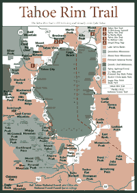
One of the highlights of the North Shore hiking and equestrian areas is the Tahoe Rim Trail, the 150-mile route that can be used to virtually circle Lake Tahoe. It has two northern entry points on the California side of the lake. The entry points are at Tahoe City and Brockway Summit.
Two other trailheads—Mount Rose and Ophir Creek—also are on the North Shore across the state line in Nevada. The rim trail has a total of 11 trailheads, spread on the South, West, and East shores.
 Tahoe
Rim Trail, Tahoe City to Brockway Summit
Tahoe
Rim Trail, Tahoe City to Brockway Summit [Fig. 28(1)] People generally hike the Tahoe Rim Trail over many summer seasons, taking one section at a time. The high country views, the wildflowers, and the panorama of the lake are the reasons most backpackers need to hike this trail. On the North Shore, most people prefer the 18.5 miles between Tahoe City and Brockway Summit. Most people do not attempt the entire section in one day.
The Tahoe Rim Trail has not been around for very long. Construction on the single-track, 24-inch wide trail began in 1981. It has about 140 miles of completed trails and nine segments. The route gets a big boost from sharing the Pacific Crest Trail for 50 miles on the west side of the lake. Each segment is anchored by trailheads with information kiosks and parking.
This is high-country hiking. The trail elevations range from 6,300 feet to 9,400 feet, and the trail does not miss many peaks or ridgetops. The trail crosses six counties and passes through parts of both California and Nevada. It is a steady average grade of about 10 percent, so it is moderate in difficulty.
In these rugged conditions, the wildflower shows are remarkable. One of the more spectacular sights above 8,500 feet is the showy polemonium (Polemonium pulcherrimum var. pulcherrimum). This light blue or sometimes violet flower blooms in open clusters. It can look like a fern with overlapping leaflets. Look for this tough little flower in the rocky outcroppings at higher elevations, ridgetops, and summits along the rim trail.
Another flower that may not be so common in other parts of the Tahoe Basin is the slender paintbrush (Castilleja tenuis), known for its small yellow flowers. It needs enough moisture to grow in abundance and disappears quickly after July. The slender paintbrush was formerly called hairy owl's clover. The flower is more apparent on the North Shore because of slightly more moisture on this side of the lake.
In vernal pools below 6,800 feet, least navarretia (Navarretia leucocephala ssp. Minima) occurs along the trail in the North Shore area. It has long, outward bracts and linear petals. It is found in midseason as things are warming up and vernal pools begin to dry. The hairy leaf and rounded flower petals of the common plant, needle navarretia (Navarretia intertexta ssp. Propinqua) can be found in many places throughout this area, but the least navarretia is not common anywhere but the North Shore.
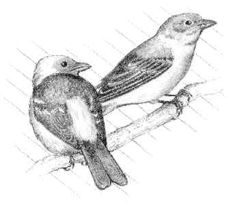 Along
this trail, migrating birds—birds that fly in for the summer to take
advantage of plant life and warmer weather to nest—are apparent. The
western tanager (Prianga ludoviciana) and the white-crowned sparrow
(Zonotrichia leucophrys) prefer the higher elevations along the red
fir and lodgepole pine forests, which provide the birds protection
from predators as well as habitat for nesting in the high Sierra.
Along
this trail, migrating birds—birds that fly in for the summer to take
advantage of plant life and warmer weather to nest—are apparent. The
western tanager (Prianga ludoviciana) and the white-crowned sparrow
(Zonotrichia leucophrys) prefer the higher elevations along the red
fir and lodgepole pine forests, which provide the birds protection
from predators as well as habitat for nesting in the high Sierra.
On this and other trails in the Sierra, hikers should carry water pumps or water purification pills to treat any water before it is ingested. Contaminants from the air, from human and animal waste, and from other sources create health hazards from such microscopic organisms as giardia and even the mysterious cryptosporidium. Anyone who does not have either the pump or the pills should boil water before drinking it.
It is also wise to be well armed with information. Anyone hiking any significant part of this trail should have a map and details. Brochures with trail information are available at trailhead bulletin boards, the Tahoe Rim Trail office, the Taylor Creek Visitors Center, and chamber of commerce offices around the lake. The Lake Tahoe Nevada State Park restricts camping to designated campsites.
[Fig. 28(2)] It does not take long to reach a vantage point of more than 8,600 feet on the North Shore. The volcanic features and the panorama of Lake Tahoe make this hike on a portion of the Tahoe Rim Trail well worth the effort.
The grade is a steady 10 percent after about 0.5 mile on a south-facing slope. If hiked in summer, plenty of water should be carried.
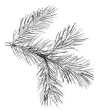
On the way up, the views include Jeffrey pine and white fir. An andesite ridgeline around 7,700 feet opens views of the lower countryside. To the west, see Truckee and Donner Pass. About 1,000 feet above, Martis Peak awaits.
In the next 2 miles, look south along the Carson Range to see Genoa Peak in Nevada. It stands 9,150 feet high. To the southeast corner of Lake Tahoe, locate the highest parts of the Tahoe rim: Jobs Sister at 10,822 feet and Freel Peak at 10,881 feet. Make sure it's a clear day. The peaks are more than 30 miles away.
By the time the Martis Lookout is reached, the views take in a wider panorama to the west into the Tahoe National Forest, which include several reservoirs, such as Prosser. Expect to see other folks in this area. It is a short haul, and it accommodates bicyclers.
[Fig. 28(3)] Backpackers enjoy hiking to 6-acre Watson Lake for the scenery and the camping at a small, quiet lake. The glacier-carved basin displays sites of volcanic eruptions over the last 10 million years.
The lake itself rests completely on volcanic rock, which makes Watson Lake a one-of-a-kind body of water, some geologists say. Water normally percolates through porous volcanic bedrock, but Watson Lake formed on particularly dense formations of volcanic bedrock.
As in other places around the North Shore, wildflowers are worth the walk. In May, June, and July, look in the protected volcanic niches along this trail for the Sierra primrose (Primula suffrutescens), the only true primrose of California. Reproducing asexually through rhizomes, this bright pink flower lights up the mountainsides in the northwest area of Tahoe.
Up on the volcanic plateaus and slopes—and even along some ridgelines—the Corry broomrape (Orobanche corymbosa) blooms with up to two dozen pink and purple flowers. They are best seen in the middle of the warm season, perhaps July. This plant is a member of the nonphotosynthesizing, leafless parasite family. The roots adapt by piercing the root systems of neighboring plants and stealing the nutrients.
[Fig. 28(4)] The Mount Rose Trail is in Nevada, which is outside the focus of this book. But Mount Rose is certainly worth crossing the state line for if hikers like wildflowers and a summit above 10,000 feet. The trail is not the best for viewing Lake Tahoe, but there are desert views to the northeast.
The alpine meadow wildflowers are brilliant in late June, July, and August along this trail. They include the dwarf knotweed (Polygonum minimum), alpine paintbrush (Castilleja nana), Anderson's alpine aster (Aster alpigenus, var. andersonii), Sierra saxifrage (Saxifraga aprica), and alpine shooting star (Dodecatheon alpinum).
Hikers will notice the weathered granite or granodiorite. It has been exposed for perhaps the last 70 million years, geologists estimate.
At the summit, the panoramic view from 10,776 feet includes Mount Tallac, jutting above the horizon to the south. Hikers also will be able to see Freel Peak to the southeast. At 10,881 feet, it is the tallest peak in the Lake Tahoe area. It is on the California side.
 Snow
Skiing And Snowplay
Snow
Skiing And Snowplay Some of the best downhill and cross-country snow skiing anywhere can be found around Lake Tahoe. North Shore has its share of skiing attractions. Early in the season, the snow is fluffy, with lower water content than the heavy, soggy snowfalls that often occur later in winter. But, even late in winter, many slopes and trails are groomed and well maintained.
The Sierra Nevada—which literally means "snowy mountain range" in Spanish—is one of the snowiest places in North America, and the Tahoe area is one of the snowiest areas of the Sierra. It is not uncommon for Tahoe to receive 20 feet of snow at 6,000 feet each year. Just south of Tahoe at the 8,000-foot level of Tamarack Peak, the average snowfall is near 40 feet a year. A few times this century, Tamarack has approached 1,000 inches of snow in a winter.
The snow is created as Pacific Ocean storms are forced to climb over the Sierra. The storms cool and drop their moisture as snow on the west slope. There usually is very little moisture left once the storms get over the crest, so the east side is quite arid by comparison.
On the west slope, particularly around Tahoe, snow accumulations make skiing available from November through May. In big winters, snow skiing takes place in June. Northstar-at-Tahoe Resort offers downhill and cross-country courses. They are normally well groomed and ready for lots of skiers because Tahoe is a ski destination for many San Francisco Bay area and Northern California residents.
[Fig. 27(7)] North Tahoe Regional Park provides cross-country access on 5 kilometers of novice trails. It's a good family place to find snowplay areas. Saucers and sleds can be rented here. For those who prefer snowmobiling, the equipment can be rented at the North Tahoe Regional Park and used on a 0.25-mile course for beginners.
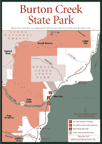 Burton
Creek State Park
Burton
Creek State Park [Fig. 29] Burton Creek State Park is an undeveloped 2,000-acre area next to Tahoe State Recreation Area (see page 135). There are no buildings or services of any kind. People use the 6 miles of unpaved roadways in the park for cross-country skiing. It is basically considered part of the Tahoe State Recreation Area.
 Northstar-at-Tahoe
Resort
Northstar-at-Tahoe
Resort [Fig. 27(2)] Here visitors can find ski classes, child care, and a slope that drops more than 1,800 feet. Northstar's runs are on Mount Pluto, which has courses for every skill level of skier.
 The
Gate Keeper's Cabin
The
Gate Keeper's Cabin [Fig. 29(1)] The cultural history of Lake Tahoe is told in the Native American exhibits, books, and artifacts in the Gate Keeper's Cabin. Washoe baskets and obsidian arrowheads are among the treasured items on display.
The cabin was the home for the official regulator of Tahoe's water level between 1916 and 1968, when control of the lake's levels was handed over to the Federal Watermaster's Office in Reno.
Agreements between Nevada and California allow a certain amount of water to be released from Lake Tahoe to irrigation projects on the Truckee River, which flows from the lake to Reno. The river empties into Pyramid Lake.
[Fig. 29(2)] The only log cabin standing in the middle of Tahoe City makes an interesting place to have a museum. The cabin has been restored almost to its original condition; it was built around the turn of the century. Robert Watson, Tahoe City's first constable, built the cabin.
The Watsons were among the first families to live in Tahoe City on a year-round basis. Robert Watson was known throughout the area because people would see him patrolling on his horse.
The Watson Cabin was occupied until 1950 when the family's daughter, Mildred, moved out. The cabin was leased as a gift shop. In 1979, the North Lake Tahoe Historical Society bought the cabin and successfully petitioned to have it placed on the National Register of Historic Places.
Read and add comments about this page