 Rabun
Bald Rabun
Bald
Rabun
Bald Rabun
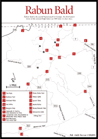
Bald Rabun Bald (4,696 feet) [Fig. 41(10)] is the second-highest peak in Georgia; only Brasstown Bald (4,784 feet) is higher. An observation tower on the summit provides hikers with what many people believe is the most spectacular view from any one point in the Georgia mountains. Into the Georgia and South Carolina Piedmont, views on clear days extend for more than 100 miles. In other directions, the views of the Blue Ridge, Nantahala, Cowee, and Great Smoky mountains are outstanding.
Rabun Bald's main ridgeline, which is indicated by the Bartram Trail on the map, is the Eastern Continental Divide, dividing waters draining northward into the Tennessee/Mississippi Gulf system from those draining southward to the Atlantic Ocean. Most of Rabun Bald's streams are located on the mountain's southeast flank and drain via Warwoman Creek to the Chattooga River, then to the Savannah River, and finally to the Atlantic.
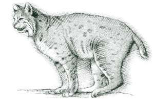
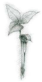
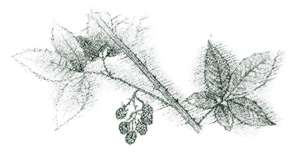
The Rabun Bald area rates among Georgia's leading botanical sites; spring wildflowers are exceptional. Near the summit is a zone of dwarf oak heath (mainly scarlet oak and purple rhododendron). Look for the striking red berries of mountain ash. In some places there is a thick ground cover of blueberries. Together with the Chattooga River to the southeast and the Cowee Mountains to the north, the region is a prime habitat for deer, black bear, wild boar, and, reportedly, even mountain lion.
 SCENIC
DRIVES
SCENIC
DRIVES WARWOMAN ROAD. A scenic drive which follows Warwoman Shear, a geologic "path" that provided Indians and early settlers in the region with their principal east-west trading route.
Directions: From US 441 in Clayton, go east at the light where US 76 turns left.
TUKALUGEE CREEK ROAD (FS 156) and SARAH'S CREEK ROAD. [Fig. 41] All-weather roads providing a 10-mile scenic loop drive. Gate closed December through March.
DARNELL CREEK ROAD (FS 150). [Fig. 41] This scenic drive is especially pretty after leaf fall, when cascading Darnell Creek and surrounding mountains are more visible. The all-weather road is rough in spots, but certainly passable. While travel is not limited to trucks or four-wheel-drive vehicles, cars with low ground clearance should be driven with care.
OVERFLOW CREEK ROAD (FS 86). [Fig. 41] This very scenic, all-weather road is open year-round. The lower sections of the road run parallel to the West Fork of the Chattooga River, providing access at several places for fishermen, hikers, and campers.
 SANDY
FORD ROAD. [Fig. 41] One
of only two unpaved road access points to the Chattooga River on the Georgia
side (Earl's Ford, below, being the other). Good canoe put-in point for Section
III of the river. Not a four-wheel-drive road, but difficult in bad weather.
SANDY
FORD ROAD. [Fig. 41] One
of only two unpaved road access points to the Chattooga River on the Georgia
side (Earl's Ford, below, being the other). Good canoe put-in point for Section
III of the river. Not a four-wheel-drive road, but difficult in bad weather.
EARL'S FORD ROAD. [Fig. 41] Old county road that once provided major access from South Carolina to Georgia by crossing the Chattooga River. It parallels and crosses Warwoman Road. Four-wheel-drive vehicle is advisable.
WARWOMAN DELL. [Fig. 41(14)] This recreation area was developed in the 1930s by the Civilian Conservation Corps. Cuts of the old Blue Ridge Railroad can be found here. This railroad was partially constructed but never operated before the Civil War. An interpretive trail with 25 numbered posts and an accompanying pamphlet identify many plants common to the region. Several rare ferns, including the walking fern, are found in the area.
APPLE VALLEY. [Fig. 41(12)] Popular, dispersed camping and fishing area managed by the U.S. Forest Service. Sarah's Creek is heavily stocked with trout. Off GA 246.
SKY VALLEY. [Fig. 41(4)] Georgia's highest valley (3,100 feet), Sky Valley, is one of the highest incorporated cities in the eastern United States, with elevations inside the city limits exceeding 4,200 feet. Sky Valley Resort includes an 18-hole golf course, swimming pool, restaurant, and condominiums, as well as year-round and rental homes. Sky Valley is best known as Georgia's only ski area, with runs up to 2,200 feet in length and a vertical drop of 250 feet. A rope tow serves the "bunny hill," and a double chairlift serves intermediate and advanced slopes. Located just off GA 246.
ALEX MOUNTAIN, FLINT KNOB TRAIL. [Fig. 41(8)] From the summit of 4,080-foot Alex Mountain are good vistas to the west and southeast. A Georgia Power microwave tower is located on the northern end of the mountain.
 THE
FLATS. [Fig.
41(1)] A remarkable, high, flat area forming the western rim of the Highland
Plateau. Formerly this was the location of a number of unique peat bogs. Among
the rarest of mountain environments, these bogs occur at the heads of valleys
where seeps and springs keep the soil consistently wet and produce rare plants
such as bog laurel, swamp pink, and cotton grass. Unfortunately, most of the
bogs here have been drained or bulldozed.
THE
FLATS. [Fig.
41(1)] A remarkable, high, flat area forming the western rim of the Highland
Plateau. Formerly this was the location of a number of unique peat bogs. Among
the rarest of mountain environments, these bogs occur at the heads of valleys
where seeps and springs keep the soil consistently wet and produce rare plants
such as bog laurel, swamp pink, and cotton grass. Unfortunately, most of the
bogs here have been drained or bulldozed.
LAUREL SLICK. [Fig. 41(11)] Very dense thickets of rhododendron are found at the 4,000-foot level of Rabun Bald's southwestern flank.
BECKY BRANCH FALLS. [Fig. 41(13)] This 20-foot-high cascade is reached by a .25-mile trail that crosses Warwoman Road just upstream from the Warwoman Dell Recreation Area.
ESTATOAH FALLS. [Fig. 41(3)] This wide falls, located just inside the western city limits of Sky Valley, is best viewed from GA 246, approximately 1 mile east of Dillard.
HOLCOMB CREEK TRAIL AND FALLS AND AMMONS CREEK FALLS. [Fig. 41(6)] The .5-mile trail to Holcomb Creek Falls and Ammons Creek Falls is rated easy to moderate. At .3 mile, the very impressive Holcomb Creek Falls, approximately 120 feet in height, comes into view from a footbridge over the creek. The trail continues approximately .2 mile to Ammons Creek Falls, where an observation deck allows easy viewing.
THREE FORKS TRAIL. [Fig. 41(9)] 9.5 miles from Rabun Bald to Holcomb Creek, or 1.4 miles from John Teague Gap to Holcomb Creek. While the Three Forks Trail originates on Rabun Bald, it is most often hiked from John Teague Gap.
BARTRAM TRAIL. [Fig. 41(2)] This National Recreational Trail stretches from the Georgia/North Carolina line over the summit of Rabun Bald to the Chattooga River. It is named for William Bartram, a naturalist who explored and wrote about this area in the 1770s. See Long Trails, Bartram Trail.
Map References: USGS 1:24,000 series: Rabun Bald.
Read and add comments about this page