 Black
Rock Mountain State Park Black
Rock Mountain State Park
Black
Rock Mountain State Park Black
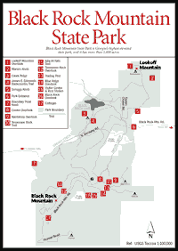
Rock Mountain State Park Black Rock Mountain State Park [Fig. 40], named for its sheer cliffs of dark granite, has the distinction of being Georgia's highest state park. It stretches over 3 miles along the Eastern Continental Divide, the spine of the southern Blue Ridge Mountains. Containing six different peaks above 3,000 feet in elevation, it covers more than 1,800 acres. From park overlooks on a clear day, visitors may enjoy views extending for more than 80 miles. Among the areas of the southern Appalachians visible are the Nantahala Mountains, the Cowee Range, and, on especially clear days, the Great Smoky Mountains.
The park is noted for its many spring wildflowers, including several varieties of trillium, violets, bloodroot, and flame azalea. In early summer, masses of mountain laurel and rhododendron are in bloom. In the fall, leaves of oak, maple, sourwood, and other deciduous trees and shrubs create a spectacular blaze of yellow, orange, and red. Evergreens present a contrasting note. Goldenrod and other fall blooms add to the show. The most common natural environment in the park is a deciduous hardwood slope forest with red oaks dominant. Chestnut oaks in drier places and white oaks in certain areas lend diversity.
Animals in the park include gray squirrels, chipmunks, opossums, black bears, foxes, woodchucks, bobcats, skunks, and occasional deer. There are wild turkey, ruffed grouse, and, in season, many songbirds.
The park's visitor center features an observation deck, wildlife exhibits, a log cabin exhibit, trail maps, and handicapped-accessible restrooms. Nature guides, raised-relief maps, hiking-trail guides, and books about mountain culture and area attractions are also available. Park rangers are on duty to answer visitors' questions. Special events include a spring wildflower program in May or June and an overnight backpacking trip in the fall.
[Fig. 40(10)] 2.2 miles. In a relatively short distance, this trail passes through several distinct environments. The entire trail is above 3,000 feet in altitude, and the first mile is located on the north side of the Blue Ridge. This cool, moist environment nourishes the growth of a variety of wildflowers, including lady slippers and umbrella leaf. Three poplar coves are found along this section of the trail. As it passes through the second of these coves, the trail lies immediately below the summit of Black Rock Mountain (3,640 feet), which is just high enough to have on its north face a small boulderfield containing herbs, such as blue cohosh, that are indicative of moist, high elevations. The trees among the rocks are primarily basswood and black birch, and the area provides fine wildflower displays in the spring and summer. After leaf fall, clumps of intermediate wood fern and alum root are visible.
Near the western border of the park, the trail passes through an almost pure stand of white pine which seeded in after intensive logging of hardwoods prior to the establishment of the park. After leaving this pine forest, the trail climbs rather steeply to the summit of Black Rock Mountain, then follows the Blue Ridge crest to Tennessee Rock Overlook [Fig. 40(12)]. This entire section of trail is above 3,600 feet in altitude. There is much rock, and the red oaks are stunted and lichen-covered; rosebay rhododendron is prevalent. Beyond Tennessee Rock, the trail remains on the crest of the ridgeline for several hundred yards before descending back to the trailhead parking area. Numbered posts along the entire length of the trail correspond to a fully illustrated, 32-page trail guide which interprets various aspects of the park's natural features. This booklet is available at the park visitor center for a small fee.
[Fig. 40(4)] 7.2 miles. Along this trail there are two patches of hemlock forest and more extensive areas of red oak–rhododendron in moist places, with mountain laurel replacing rhododendron in drier locations. Where the rhododendron is thin, large patches of evergreen galax, or coltsfoot, are present.
A short side trail leads hikers to the summit of 3,162-foot Lookoff Mountain, the northernmost peak in the park. Several granite cliffs are visible from the trail, and the scenic overlook on Lookoff Mountain [Fig. 40(1)] is atop a similar outcrop. Cliff faces drop several hundred feet straight down, and granite surfaces are often surprisingly slippery. Hikers are cautioned to remain on the trail and not be tempted to explore more closely these beautiful, but potentially deadly, cliff faces.
While the name "Greasy Creek" may not be particularly poetic, the section of trail that follows this mountain stream is nonetheless very scenic, with numerous small shoals and cascades framed with rhododendron and hemlock.
[Fig. 40(11)] .2 mile. Ada-Hi (pronounced Uh-dah`'he) is the Cherokee word for "forest." This hike begins in the most common natural environment in the park—a deciduous hardwood slope forest dominated by red, chestnut, and white oaks. This forest then phases into a red oak–rhododendron environment with huge patches of the evergreen galax in open places. The trail ends in a cove of tulip poplars at a wooden overlook platform which allows hikers to view the falls safely and easily.
Because Ada-Hi Falls is located so high in the Taylor Creek watershed, the falls are small; during extended periods of dry weather the flow of water diminishes to a trickle. Even so, with dense thickets of rhododendron arching over the trail and colorful displays of wildflowers to view, most hikers find the trail quite enjoyable.
Map References: DNR Black Rock State Park map.
Read and add comments about this page