 John
W. Flannagan Dam and Reservoir
John
W. Flannagan Dam and Reservoir Dickenson County and the Pine Mountain section of Wise County, rimmed by mountains, can be compared to a tray tilted toward one corner. Rain falling here from the southeastern slope of Pine Mountain east to Russell County eventually finds its way out a crack on Dickenson's northeast corner and into West Virginia. That crack is called Breaks Gorge. The last chute funneling the water out of the crack is Russell Fork. Hundreds of streams empty the plateau of Dickenson, winding down through sandstone hollows where homes perch on the sides of steep hillsides. On its way to The Breaks, the water supplies three major rivers (Pound, Cranes Nest, and Russell Fork) and two reservoirs (North Fork of Pound [Fig. 10] and John W. Flannagan [Fig. 9]). Before the water leaves the state, Virginians dam it twice, fish it, ride boats over it, swim in it, hike and camp on its borders, and enjoy the scenery around it. Then, released from Dickenson County, the Russell Fork heads northwest into Kentucky for the Big Sandy River.
Most of the Big Sandy watershed that drains Pine Mountain in Virginia is protected by national forest land. April and May warmth encourages the buds of oaks, hickories, and tulip poplar (Liriodendron tulipifera) to sprout. The understory attracts pollinators with splashes of white from flowering dogwoods, purple from redbuds, and rose pink from rhododendrons. Emerging from the leaf litter is the abundant large-flowered trillium (Trillium grandiflorum), with sepals and white petals in threes.
In October, the lakes and rivers of the Big Sandy watershed paint an upside-down watercolor reflection from a fiery palette. Red maples, glowing yellow poplars, and rusty-red pin oaks (Quercus palustris) are set off by the patchy beige and white bark of sycamores (Ficus sycomorus) leaning out over the water. While black bear, white-tailed deer, and wild turkey are native to the area, they were hunted out in the early 1900s. The Virginia Department of Game and Inland Fisheries is currently restocking all three animals. At present, hunters are more likely to have success with small game such as squirrel, rabbit (Oryctolagus cuniculus), and ruffed grouse (Bonasa umbellus). Beaver (Castor canadensis), raccoon (Procyon lotor), muskrat (Ondata zibethicus), and mink (Mustela vison) are active around the waterways. The long-legged bird with a slate-blue body fishing the shallows of the reservoirs is the great blue heron (Ardea herodias). Great blues usually migrate south in the fall. The occasional bird that stays behind may fall victim to severe weather.
The excellent fishing available in the Pine Mountain drainage is well known to locals but largely undiscovered by the rest of the world. To take advantage of this uncrowded angler's and boater's mecca, anglers should grab their fishing license and rod and reel, and stop by a tackle shop for tips on what's biting where. Licenses and trout stamps are available at marinas at both reservoirs and at area stores.
[Fig. 8(21)] The Russell Fork of the Big Sandy River begins along VA 80 in southern Buchanan County. The river gains strength as it collects tributaries on its journey northwest into Dickenson County. In northern Dickenson, waters from the Pound and Cranes Nest rivers are dumped into the Russell Fork below John W. Flannagan Reservoir. It is here that the Russell Fork earns its national reputation for ferocity and great natural beauty.
With miles of churning whitewater, thundering drops, and immense boulder gardens, Russell Fork cuts an impressive hole through the northeastern end of Pine Mountain, the location of Breaks Interstate Park. Over millennia, the river has carved its twisting and tumultuous route out of subtly colorful Pennsylvanian sandstone in Virginia's Dickenson County, as it heads inexorably northwestward. The river then continues its plunge into adjoining Kentucky.
Loggers once used the Russell Fork to float timber that had been cut and hauled to the river during winter. When spring floods came, the logs were released to race their way to Elkhorn City, Kentucky, to be sold. The VA 611 bridge near the confluence of the Russell Fork and Pound rivers at the small community of Bartlick played an important role. Gates forming a dam to back up massive log rafts once hung from the bridge piers. Russell Fork is visible from the high overlooks of Breaks Interstate Park, and from several roads crisscrossing the area. Among them are VA 80, VA 611, and VA 739. The latter crosses Flannagan Dam. At several points along Russell Fork's route, the Virginia Department of Game and Inland Fisheries stocks trout for fishermen.
Rafting and Boating the Russell Fork. Rafters, canoeists, and kayakers travel great distances to run the Russell Fork, but the river can be very unkind to all but expert paddlers. In the 5-mile-long gorge section, which flows through the park, paddlers may find themselves twisting through intense and dangerous Class V rapids while trying to glance upward at vertical cliff walls more than 1,600 feet high.
This is world-class whitewater, and it is best to run it with an experienced guide or outfitter during the first four full weekends in October, when large amounts of water are being released at Flannagan Reservoir. Only then is flow great enough to cover the boulder gardens. Call the dam at (540) 835-9544 for release times. The gradient, or drop, of the Russell Fork ranges from an occasional, gentle 5 feet per mile all the way to a white-knuckle 180 feet per mile. One violent 75-foot stretch, called "El Horrendo," is considered one of the wildest in the East.
The list of commercial companies that run the Russell Fork varies from year to year. Some outfitters that once ran the river have concluded it was too dangerous. The current list is as follows: Russell Fork Expeditions, (800) THE-FORK; Upper Yough Whitewater Expeditions, (800) 248-1893; Russell Fork Whitewater Adventures, (540) 530-7044; Cherokee Adventures, (800) 445-7238; Sheltowee Trace Outfitters, (800) 541-RAFT; American Whitewater, (800) 837-3022.
John
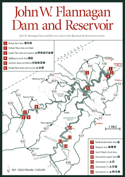
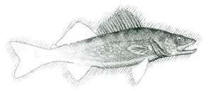
W. Flannagan Dam and Reservoir [Fig. 9, Fig. 5(9)] Built in 1964 as part of the Big Sandy River flood control complex, John W. Flannagan Dam and Reservoir became, as did many U.S. Army Corps of Engineer lakes, much more than just a way of storing vast amounts of water in the mountains. The blue-water lake—considered one of the cleanest in the United States—threads its way into many narrow coves and hollows. The 250-foot-high dam impounds 1,145 acres with 40 miles of shoreline. The water is deep (175 feet at the dam intake), and the sheer sandstone cliffs along its banks provide ideal hiding places for cold-water species of fish such as walleye and trout. In fact, this 13-mile-long lake is one of the premier walleye lakes in the state, second only to Lake Moomaw in Alleghany County. McConaughy rainbow and Crawford brown trout are stocked yearly by the state. Keepers must be at least 16 inches in the lake, with a creel limit of two fish daily. In the Pound and Cranes Nest rivers, keepers must be 7 inches, with a creel limit of six. Anglers are permitted to keep five Flannagan bass of 1 foot or more in size daily. For other restrictions, check state fishing regulations, available at the lake office and area stores.
Periodically, lake waters are released through a 16-foot-diameter outlet tunnel drilled through a mountain at the dam site. The purpose of the water releases is to increase the late-summer river flow below the dam, and to make room for winter snow melt and spring floods. The largest amounts are let go on the first four full weekends in October, an event whitewater rafters, canoeists, and kayakers eagerly anticipate. Several outfitters in the area take people down the Russell Fork River through Breaks Interstate Park for a turbulent but scenic fall ride (See Rafting and Boating the Russell Fork).
Flannagan has three campgrounds—Lower Twin [Fig. 9(3)], Pound [Fig. 9(6)], and Cranesnest [Fig. 9(11, 12, 13)]—in addition to five boat ramps, several picnic areas, play areas, two amphitheaters, and a marina. The development of hiking trails has not been a priority here. Girl Scouts established a .75-mile guided loop trail at Lower Twin area [Fig. 9(3)] called Trail of Trees. Another .75-mile trail and a 2-mile trail connect Lower Twin to other areas. Other paths have formed from the feet of many fishermen and even wildlife walking the lake edge. Many of these paths are steep in places and need work to be called hiking trails. Elevations begin at 1,400 feet, and surfaces are hard-packed dirt.
Those who enjoy recreational boating but don't like competing for space should try Flannagan, where most of the fishermen are back in coves and hollows. An osprey catching its fishy lunch from the lake may provide entertainment when the fish aren't biting. Watch the banks for a mink taking its young to the water's edge for a drink or a multicolored wood duck (Aix sponsa) sticking its head out of a hollow in a nesting tree. Both red and gray foxes hunt the lake's perimeter for mice and voles.
Campgrounds at Flannagan Reservoir. At this uncrowded facility, visitors can usually choose between open and shady sites, some lakeside, and some in woods. Pets must be leashed. Loaded firearms and fireworks are prohibited. Fires are permitted only in grills or designated places. Complete camping rules are available from any ranger, the lake office, or the gate attendant at the campground.
Lower Twin. [Fig. 9(3)] 33 sites, restroom and showers, hiking trails, picnic area, play area, amphitheater, boat ramp.
Pound River. [Fig. 9(6)] 23 lakeside sites with boat access, boat ramp, restrooms, drinking water. Nearby, Dickenson County provides areas for ball fields, a swimming pool, and a show ring for horses.
Cranesnest. [Fig. 9(11, 12, 13)] 37 sites in three areas, some with concrete or gravel base, picnic area and picnic shelter, amphitheater, restrooms and showers, play area, trailer dump station.
 North
Fork of Pound Lake
North
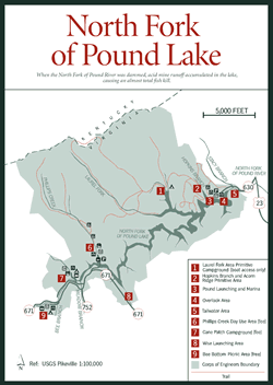
Fork of Pound Lake [Fig. 10, Fig. 5(10)] By damming the North Fork of Pound River in 1966, the U.S. Army Corps of Engineers created North Fork of Pound Lake, a long, thin, pristine body of water in the secluded mountains of southwest Virginia. At only 154 acres, the lake is neither broad nor large. It threads, instead, into scores of secluded coves and narrow hollows created by the steep terrain. As a result, 13.5 scenic miles of wooded shoreline encircle the lake, much of it accessible by walking trails (see Hiking at North Fork of Pound Lake) or state roads (VA 630, VA 671, and VA 752).
North Fork of Pound Lake got off to an unpromising start. When the river was dammed, acid mine runoff accumulated in the lake, causing an almost total fish kill. Lime was added to the incoming upper end of the lake to bring the pH level back to normal. Then the lake was restocked with both native and exotic fish. Today spotted bass are abundant, a 26-pound muskellunge was caught in the lake in 1993, and the North Fork of Pound River below the dam is stocked with trout by the state Department of Game and Inland Fisheries (see Fishing North Fork of Pound Lake).
The lake is especially attractive for a day or a weekend of canoe cruising. Since the whole lake is a no-wake zone, this is not the place for high-powered bass boats. Land around the lake is part of the Clinch Ranger District of the Jefferson National Forest. The Ranger District has also taken over operations of lake facilities from the Corps of Engineers.
Camping in the area around the lake ranges from uncrowded backcountry to car camping in a meadow campground. Hikers also enjoy a selection of walking trails that include old roads and abandoned railroad beds and wind past small waterfalls and interesting rock formations, and through hemlock and rhododendron thickets. Other recreational facilities include two launch ramps, and picnic areas.
 Camping
and Recreation at North Fork of Pound Lake
Camping
and Recreation at North Fork of Pound Lake Three types of camping are available—backcountry camping with no facilities, primitive camping accessible only by foot or boat, and camping at a developed campground. Picnicking is available at Bee Bottom Picnic Area [Fig. 10(9)], Pound Launch Overlook [Fig. 10(3)], and Laurel Fork Camping and Picnic Area [Fig. 10(1)].
Cane Patch Campground. [Fig. 10(7)] This is the only developed campground at North Fork of Pound Lake. It's on a flat area at the southwestern end of the lake, with play areas for children, basketball and volleyball courts, and fields for ball games. Use is light on weekdays, and moderate to heavy on weekends.
Laurel Fork Primitive Campground. [Fig. 10(1)] For a quiet setting in the Jefferson National Forest, hike or boat to this spot on a cove in the upper lake. Facilities include primitive campsites, picnic areas with cooking grills, and boat tie rings. The Laurel Fork Trail, which begins at the Pound launch, leads to the campground.
Backcountry Camping. The Jefferson National Forest surrounding the lake is completely open for camping. Visitors should check on possible restrictions on campfires, carry water along, pack all litter, and leave no trace of a visit to this wild country.
Phillips Creek Group Camping and Picnic Area. [Fig. 10(6)] By reservation only. Located near the southwestern end of the lake, this area also features a well-placed interpretive trail.
Bee Bottom Picnic Area. [Fig. 10(9)] Bee Bottom is maintained with families and recreation in mind. Mowed open areas invite children to run and offer a place for ball games. Hardwood trees surround the open area.
Phillips Creek Loop Trail. [Fig. 10(6)] This easy, self-guided nature trail leads hikers first along an abandoned railroad bed and then to an old homestead where apple and peach trees planted by the owners still provide food for deer.
Wildlife food plantings of lespedeza, persimmon (Diospyros virginiana), and black walnut (Juglans nigra) line the trail. An Indian grave is one highlight. Waterfalls have carved beautiful patterns in sandstone rock, and footbridges across streams lead to the remnants of a whiskey still.
Laurel Fork Trail. [Fig. 10(1)] Though difficult, the rock formations and variety of plant life and wildlife make this trail worth the effort. It begins at the Pound launch parking lot and takes off up a steep slope for approximately .5 mile. The Laurel Fork Trail connects to old logging roads and other trails on Pine Mountain. Follow signs to Laurel Fork.
 Fishing
at North Fork of Pound Lake
Fishing
at North Fork of Pound Lake Spotted bass are abundant but small in the lake. Crappie and bluegill fishing is good. Channel catfish and muskie have been stocked. A fair population of smallmouth bass and redbreast sunfish also find the cool lake water to their liking. Below the dam, the North Fork of Pound River is a medium-size stream with shallow runs and riffles.
The state stocks trout in the river on a regular basis. A state fishing license and a trout stamp are required. Normally, a national forest stamp is required if fishing on federal property, but one is not required at North Fork of Pound Reservoir. The river passes through the town of Pound, where parking and licenses are available. Best times to fish for trout are October through early summer.
Directions: Pound launch: Take US 23 bypass at Pound, turn west off the bypass on VA 630 at the junction with Business US 23 into Pound and follow VA 630 .9 mile to launch. Wise launch: Take US 23 bypass at Pound, turn west on VA 671, and continue 5.1 miles to launch.
Read and add comments about this page