The Cumberland Plateau is the name given to the southern part of the Appalachian
Plateau that extends from the western border of New York through Tennessee
into central Alabama. The Cumberland Plateau contains about 4,300 acres in
the swath that is about 55 miles wide on the northern border of Tennessee near
the Virginia/Kentucky line and less than 40 miles wide at the state's southern
border near Chattanooga.
It is a 2,000-foot high, sandstone-capped tableland bordered on the east by the Valley of East Tennessee, and on the west by the Eastern Highland Rim. Much of the plateau is flat, although there are some rolling hills, a few higher mountains, and numerous deep gorges. Prominent escarpments with an average height of 900 feet mark both sides. The general plateau elevation is approximately 1,700 to 1,900 feet, but a few of the mountains have elevations over 3,000 feet.
There is considerable difference between the escarpments on each side. The eastern escarpment is abrupt, smooth to slightly curving, and only occasionally notched by drainage that empties into the Tennessee River. It is a line of bluffs that served for many years as a barrier to westward migration.
When James Robertson led the first settlers into the Great Valley in 1776, they were halted by this gigantic wall, which had no apparent gaps or openings. Robertson used what can only be described as extreme measures. To circumvent it, he sent part of his expedition, under the command of Col. John Donelson, by flatboat down the Holston and Tennessee rivers and on to the Ohio River, up the Ohio to the Cumberland River, and up the Cumberland to Nashville. Even after the Cumberland Gap was discovered, and Robertson and Daniel Boone began moving parties through it to Kentucky and Tennessee, there were still people who preferred to go the long way around rather than across the plateau.
Had the topography of the plateau been reversed, access to it would have been a less challenging task because the western edge is ragged and deeply incised by several river systems. The gaps created by these drainages would have provided relatively easy passage.
The differences in the topography between the eastern and western edges of the plateau have to do with how and where the early mountain-building pressures were applied. Approximately 250 million years ago, the forces that formed the plateau came from a southeasterly direction. This resulted in tight folding along the eastern edge of the plateau, but elsewhere the rock was compressed to the point of breaking. Large-scale breaks, properly called faults, allowed large masses of rock to move along the break lines. The entire group of faults is called the Cumberland Overthrust Fault, although it is not a single fault but an interwoven and complex system along which some parts of the plateau moved only slightly while others moved as much as 10 miles. The most prominent movement was the 125-mile-long offset on the northern escarpment that was pushed to the northwest at what is now Lake City. This massive, displaced portion of the plateau that extends into Kentucky and Virginia is known as the Cumberland Block.
The western edge of the Cumberland Plateau is irregular and undefined because the Cumberland, Elk, and Duck rivers and their tributaries have reshaped it. Also, the effects of the thrusting and faulting 250 million years ago diminished over distance. The western edge of the plateau did not suffer the shifting of its hard sandstone cap to an inclined position as occurred on the eastern escarpment.
The rocks on the plateau are primarily sandstone, siltstone, coal, and shale formed during the Pennsylvanian Period. The force from the collision with Africa 250 million years ago did not produce enough pressure and heat on the Cumberland Plateau to metamorphose these rocks.
The extensive folding and faulting of the hard sandstone caprock on the eastern half of the plateau exposed to erosion underlying layers of softer sedimentary deposits laid down during the Paleozoic Era. In one of these layers, which represents the Pennsylvanian Period, deposits of vegetation became carbonized after being subjected to enormous pressure over millions of years. Coal was formed, and its discovery led to widespread exploitation of the plateau, primarily by strip-mining. Although this practice is more tightly regulated today, it is still conducted at some locations.
While coal is found at various places on the plateau, the largest amount of strip-mining has traditionally occurred in Morgan, Scott, Campbell, and Anderson counties in a broad, downwarped area surrounded by resistant caprock. Inside the basins are high mountains carved from folded layers of sedimentary rocks that have long since disappeared from other parts of the plateau.
Initially, the plateau served primarily as a seasonal hunting ground for the Cherokee and Shawnee Indians, who never established permanent village sites. Instead, they used caves and rock houses cut by the streams and rivers along the walls of the steep canyons as their temporary quarters. Some of these homes are important archeological sites. Later, the longhunters of the Daniel Boone era (so named because of the long duration of their hunting forays, or because of the long rifles and long knives they carried) used some of the rock houses for shelter before they built cabins as hunting bases.
Few immigrants settled on the plateau because of its rugged nature, and most knew of the rich farmlands in Middle Tennessee. From the outset until the present day, the plateau has remained Tennessee's last frontier, still sparsely populated in comparison with other parts of the state.
Yet the highland area wasn't totally overlooked. Early on, its natural resources attracted mining and lumber companies, and the plateau was literally stripped of coal and timber. The economic booms these ventures created began in the closing years of the nineteenth century. Early logging involved selective, labor-intensive removal of certain species of trees like oak and poplar located near waterways. Oxen were used to haul wood out of steeper areas to the river where rafts of logs were floated down river during the rainy season to markets in Celina, Carthage, and Nashville.
Later years brought railroads, improved roads, portable sawmills, and widespread commercial logging. Along with commercial logging came the introduction of the practice of clear-cutting, or the removal of essentially all the trees in a particular area, leaving the soil vulnerable to erosion. Due to the rugged terrain, some of the steepest areas remained inaccessible to clear-cutting methods of timber harvesting.
Although residents mined coal on a small scale prior to 1880, interest in commercial coal mining by the timber companies as well as other operators began to grow rapidly in the early 1900s. Early mining activity utilized tunnels cut into hillsides to reach coal seams. Later strip-mining became the primary method of coal extraction. Sediment and refuse from mining activities degraded once crystalline streams.
During the Great Depression, the timber market deteriorated, and by the end of World War II, the coal reserves were becoming depleted. The boom gradually departed the Cumberland Plateau, taking with it many of the families who had settled in the area and leaving the damage created by man's activities to slowly heal.
Second-growth forests have been successful in growing where humans let them, occupying about 75 percent of the area. Unlike the Unaka Mountains with many forest types, the Cumberland Plateau has the upland forests on the tableland and mountain areas with the ravine forests occupying the lower elevations, including gorges.
In the Cumberland Plateau, mixed oak forests dominate the tableland and mountains. Shortleaf pine, white oak, and chestnut oak grow on the ridgetops, with a sprinkling of sugar maple, basswood, buckeye, tulip poplar, and beech. Tulip poplar, red maple, black gum, and sourwood can be found among oaks along wetter areas.
Mixed-oak woods attract the turkey, gray squirrel, and opossum with mast and thick undergrowth. Birds, including the red-eyed vireo (Vireo olivaceus), scarlet tanager (Piranga olivacea), and tufted titmouse (Parus bicolor) prefer the canopy whereas the wood thrush, hooded warbler, and downy woodpecker (Picoides pubescens) favor the understory.
The ravine forests, growing in the gorges of the Upper Cumberland Plateau, consist of beech, sugar maple, red oak, tulip poplar, white oak, chestnut oak, basswood, sweet buckeye, white pine (Pinus strobus), hemlock, yellow birch, black cherry, white ash, red maple, and umbrella and cucumber magnolias. Sour gum, black walnut, and hickory are occasionally found among these species. The ravine forests' understory includes rhododendron, mountain laurel, dogwood, hop hornbeam, sourwood, redbud, ironwood, serviceberry, and sassafras. Herbaceous flowers include trillium, mayapple violets, delphinium, phacelia, phlox, bloodroot, spring beauty, fire pink, wild iris, anemone, and many others. Not all these herbaceous plants thrive in any one area. Elevation, light, soil, nutrients, and moisture produce different habitats that sustain different plants.
On the edge of the river gorges, pine, chestnut oak, sourwood, and various shrubs hold in the soil. On the floor of the gorges grows sycamore and river birch with wild oats and cane living beneath them. Sugar maple, beech, poplar, basswood, ash, and buckeye grow on the low moist slopes. The understory and groundcover are sparse among hemlock and rhododendron stands. The gorge walls are also sparsely covered with plants because of the lack of soil. Alum root, ferns, and small pines marshal a living among the crevices. Certain animals depend on these walls for their habitat, including vultures, Eastern phoebes (Sayornis phoebe), cliff swallows (Petrochelidon pyrrhonota), bats, timber rattlesnakes, and copperheads.
The gray fox, skunk, raccoon, barred owl (Strix varia), red-shouldered hawk (Buteo lineatus), shrews (Sorex sp.), Eastern mole (Scalopus aquaticus), Eastern woodrat (Neotoma floridana), white-footed mouse (Peromyscus leucopus), and Eastern chipmunk make their living on the lower slopes of the ravine forest.
The forests at the bottom of the gorges provide food and habitat to beaver, muskrat (Ondatra zibethicus), mink, otter, Louisiana water thrush, spotted sandpiper (Actitis macularia), and American woodcock (Philohela minor). Along the stream banks and in the very narrow floodplains of sand, gravel, and boulders are bullfrogs (Rana catesbeiana), southern leopard frogs (Rana sphenocephala), pickerel frogs (Rana palustris), water snakes (Nerodia sp.), and midland painted turtles (Chrysemys picta). The belted kingfisher (Megaceryle alcyon) and green heron (Butorides striatus) are two common water birds living along the streams.
The topography of the plateau causes the rivers to flow in different directions. The Big South Fork, Caney Fork, Calfkiller, and Collins rivers flow north and west into the Cumberland River, while the Obed, Emory, and Sequatchie rivers flow south and east into the Tennessee River.
The rivers of the plateau and their tributaries carved gorges, and the walls are of the gorges exposed sandstone layers. Waterfalls, rock houses, and natural stone arches are results of the erosion of the softer rock under the sandstone layers.
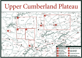
The Upper Cumberland Plateau is bracketed on the west by the western escarpment of the plateau; on the east by the eastern escarpment consisting of Walden Ridge and Cumberland Mountain; on the south by Interstate 40; and on the north by the Tennessee/Kentucky/Virginia state lines. There are two exceptions: all of the Big South Fork National River and Recreation Area that lies in both Tennessee and Kentucky is covered in this chapter, and so is the Cumberland Gap Historic Park that lies in Tennessee, Kentucky, and Virginia.
The Upper Cumberland Plateau contains all or parts of Claiborne, Campbell, Scott, Pickett, Fentress, Overton, Morgan, Putnam, Anderson, Cumberland, and Roane counties.