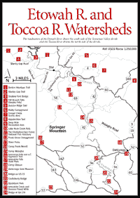
The Etowah River and the Toccoa River flow in different directions. The Etowah drains the south side of the Tennessee Valley Divide, while the Toccoa drains the north side. In these watersheds, visitors will find the highest waterfall in Georgia, as well as the approach trail for the beginning of the Appalachian Trail. A fish hatchery allows one to see how the hundreds of thousands of rainbow trout stocked in Georgia's rivers and streams are raised to catching size. The two fine rivers provide canoeing opportunities for boaters of varying skills and experience.
ETOWAH RIVER. The upper section of the Etowah River is ideal for beginning canoeists, families, and organized groups who want to run a brisk mountain river and also be close to the scenic and historical attractions of Dahlonega. A 12-mile stretch can be canoed in one day of steady paddling or two leisurely days. (Those opting for the two-day version can break the trip at Castleberry Bridge and camp at the nearby Blackburn Park [Fig. 19(22)] 1.3 miles south of Auraria on GA 9E or go into Dahlonega 7 miles south on 9E.)
One hazard is Etowah Falls, 1.5 miles from the put-in. The canoeist must land on the rocks on the right bank and portage over or around them. Below Castleberry Bridge [Fig. 19(21)] is an old mine tunnel about 7 feet in diameter and about .2 mile long. Scout this carefully. Run it only if light is visible at the other end; if the exit light is not clear and bright, the tunnel is likely to be too obstructed with debris and stumps to be safely passable.
 TOCCOA
RIVER. Some knowledgeable canoeists have described the Toccoa [Fig.
17(18)] as Georgia's prettiest whitewater stream. It has its headwaters
in Union County, flows into Fannin County, and becomes the major feeder stream
for Lake Blue Ridge. It resumes its flow below Blue Ridge and travels into Tennessee,
where it is known as the Ocoee.
TOCCOA
RIVER. Some knowledgeable canoeists have described the Toccoa [Fig.
17(18)] as Georgia's prettiest whitewater stream. It has its headwaters
in Union County, flows into Fannin County, and becomes the major feeder stream
for Lake Blue Ridge. It resumes its flow below Blue Ridge and travels into Tennessee,
where it is known as the Ocoee.
The stream's first couple of miles illustrate the startling contrast between undisturbed river banks and those touched by human hands. In apparent efforts to squeeze a little more yield from floodplains, some farmers have cleared to the edge of the water, removing vegetation which holds the soil. The unhappy consequence is that the banks are rapidly eroding, dumping silt and any remaining vegetation into the water.
The river offers a variety of interesting forms of vegetation for each season. Early spring brings bluets in the moss, then azalea, laurel, and—all around Deep Hole Campground—wild strawberries. In late spring, abundant rhododendron garnishes the banks. Summer offers the richness of mature hardwood stands in full leaf. When autumn comes, the hardwoods take on an incredible glow. Alternate leaf dogwood and deciduous holly sport their bright red berries right on into winter. When upper-story trees provide enough shade, galax carpets the banks. The waxy leaves are dark green until December, then they thrive as coppery as pennies for the winter months. Galax is gathered frequently for use in floral arrangements. Sadly, this has led to its near-extinction in many areas.
The most beautiful section of the Toccoa River lies behind Toonowee Mountain. Small rapids, hemlocks trailing in the water, and the beautifully clear stream itself combine to saturate the senses.
LONG CREEK FALLS. Picturesque falls and trail. Requires a 20- to 30-minute walk in each direction.
FALL BRANCH FALLS. [Fig. 19(4)] A fine double waterfall.
LITTLE ROCK CREEK FALLS. [Fig. 19(10)] There is a series of small falls just before reaching the main one. The walk is strenuous on a footpath leading along the left side of the creek and going only part of the way to the falls. Go no farther than this because of the dangerous, slippery rocks in the area.
THE CHATTAHOOCHEE FOREST NATIONAL FISH HATCHERY. [Fig. 18(9), Fig. 19(11)] The hatchery produces rainbow trout for stocking in rivers, streams, and lakes of the Chattahoochee National Forest and other areas of north Georgia. While spawning operations are not conducted at this hatchery, fertilized eggs are shipped here and incubated under controlled conditions. Eggs hatch within three to four weeks, and the young fry are soon placed on a specially formulated dry feed. Upon reaching 2 to 3 inches in size, the fingerlings are moved to outside raceways for rearing to catchable size. The hatchery turns out about 850,000 trout each year. These fish are harvested from the hatchery's raceways and distributed by truck for stocking into streams, lakes, and reservoirs of north Georgia in cooperation with the State Game and Fish Department. There are signs located throughout the grounds to explain the hatchery and its operations, and there is a sheltered exhibit.
There is fishing in Rock Creek by the hatchery, and nearby Cooper Creek is an angler's paradise for trout fishing.
FRANK GROSS CAMPGROUND. [Fig. 19(11)] This is a small campground located along Rock Creek near the Chattahoochee National Fish Hatchery. Fishing is allowed (at no charge) in the adjacent Rock Creek and also in the 13.5-acre Rock Creek Lake, 1.7 miles farther west on the right side of Fish Hatchery Road. The lake is managed by the National Fish Hatchery, and the creek and lake are stocked periodically with 9-inch rainbow trout.
DEEP HOLE RECREATION AREA. [Fig. 19(9)] A small campground located in an attractive mountain setting on a bend of the Toccoa River just north of the fish hatchery. Its name comes from a deep hole in the river by the campground. This is an excellent canoe launch for the Toccoa River.
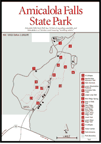 Amicalola
Falls State Park
Amicalola
Falls State Park Amicalola is a Cherokee word meaning "tumbling waters," an appropriate label since the park's beautiful falls [Fig. 19(16)] slide and plunge in seven cascades 729 feet, making it the highest waterfall in Georgia. It tumbles southwest through a cove of Amicalola Mountain and forms part of the Amicalola Creek watershed. This, in turn, feeds into the Etowah River, which joins the Oostanaula River to form the Coosa River near Rome.
The park, nestled along the southernmost edge of the Blue Ridge Mountain chain [Fig. 19(17)], consists of more than 1,440 acres surrounding the waterfall. The forest types include cove hardwood, upland oak-hickory, and mixed pine and hardwood.
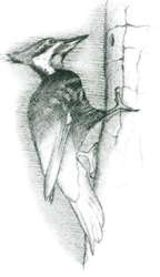
Both mountain and Piedmont flora and fauna can be found, and most of the species native to this region inhabit the park. Here, a small colony of pink lady slippers grows, pileated woodpeckers nest, and the Eastern milk snake reaches its southernmost range.
All seasons are beautiful at Amicalola Falls. Spring and summer offer an abundance of wildflowers, including dogwood, mountain laurel, and rhododendron. Autumn offers brilliant colors in the forest, and the winter months hold a special magic as the deer and other wild animals seek refuge within the park. April and May are ideal times to enjoy the waterfall because of the unusually high volume of water. Little Amicalola Creek flows through the park and provides an opportunity for trout fishing.
Naturalist programs are provided year-round, Thursday through Sunday, on topics dealing with the area's natural, cultural, and historical resources. Other programs are featured throughout the year. A schedule is available in the park office.
AMICALOLA FALLS HIKING TRAIL. [Fig. 20(8)] .25 mile. The most scenic trail in Amicalola Park leads to the base of Amicalola Falls. The easy walk, marked with red blazes, follows a rocky path uphill along cascading Amicalola Creek. Several large yellow poplars tower over the trail as it leads through a cove hardwood forest and ends at the lower observation deck.
WEST RIDGE SPRING TRAIL. [Fig. 20(9)] A 2.6-mile, easy nature trail within the park. Virginia pine is the dominant tree along much of the trail.
APPALACHIAN TRAIL APPROACH TRAIL. [Fig. 20(2)] 8.1 miles. Springer Mountain (3,782 feet) [Fig. 19], the southern starting point/terminus for the Appalachian Trail (AT), is reached by this hike from Amicalola Falls State Park. The trail is strenuous, up and down along the peaks and knobs of Amicalola Mountain, and is a good testing ground for those contemplating longer hikes on the AT.
LODGE LOOP TRAIL. [Fig. 20(6)] .25 mile. Easy, almost level, paved loop with interpretive signs. Trail passes beautiful vistas where frequently birds of prey may be seen sailing on thermal air currents over waterfall corridor.
 Amicalola
Creek & Dawson Forest Wildlife Management Area
Amicalola
Creek & Dawson Forest Wildlife Management Area [Fig. 19(23)]. South of Amicalola Falls State Park, on Amicalola Creek in the Etowah River Basin, the Georgia Department of Natural Resources (DNR) operates a 4,700-acre wildlife management area. Knowledgeable canoeists and naturalists consider the Amicalola to be one of Georgia's most beautiful and exciting waterways. More river than creek in size, the Amicalola was one of the top three candidates in the nationwide search for a river to be designated as the first National Wild River Park. Georgia Highway 53 crosses the midpoint of the Amicalola, approximately 7 miles west of Dawsonville. Dawsonville can be reached from GA 400 by traveling west on GA 53.
On the southeast side of the GA 53 bridge is a guide marker which graphically depicts the river, access points, more prominent rapids, and difficulty ratings. First-time users in particular should pay close attention to the information on the marker.
There are several put-in points above the GA 53 bridge, including Six Mile and Devil's Elbow. Both are state-maintained. Some parking is available, camping is allowed, and launching is easy.
The take-out for boating above the GA 53 bridge (and put-in for boating below the GA 53 bridge) is near the DNR ranger's cabin on the northeast side of the bridge. Parking is not allowed at the cabin, but adequate parking is available on the shoulders of GA 53 at the bridge.
There are no access points on the Amicalola below the GA 53 bridge until one reaches the Etowah River. Take-out is on the Etowah, 2 miles below the confluence with Amicalola Creek, at a concrete ramp near Kelley Bridge. Access to Six Mile and Devil's Elbow is reached by proceeding west on GA 53 approximately 1 mile and turning north at the first paved road (County Road 192). Turn right at the first major intersection to reach Devil's Elbow. Continue north at the intersection and watch for the sign for the Six Mile put-in.
The GA Highway 53 bridge marks a dividing point in the Amicalola's difficulty. The section above the bridge is ideal for teaching and intermediate canoeing. This section begins as easy water and grows progressively more difficult.
Several long "rock gardens," a 5-foot drop, and a deceptive "roostertail" mark this section. Below the GA 53 bridge is the most difficult water on the river. Beginning with the "Edge of the World," a Class IV rapid about .5 mile below the bridge, there are several Class II–IV rapids which should be attempted only by expert boaters. Low-water conditions usually are present after June. A foot trail leads down the east side of the river to "Edge of the World."
The beauty of this river, with its steep banks, gorges, and mountain vegetation, cannot be overemphasized.
[Fig. 19(19)] America's first major gold rush took place not in California, but in the southern Blue Ridge Mountains in the vicinity of Dahlonega during the late 1820s. The town's name, in fact, comes from the Cherokee word for gold, talonega, which translates literally as "precious yellow color." Gold was first discovered by white men near Dahlonega in 1828. Four years later, large discoveries of the precious metal were made in nearby Auraria. It was not until 1848 that gold was discovered in California and the gold rush occurred there.
From 1838 until 1861, the U.S. government operated a mint in Dahlonega which manufactured a total of $6 million worth of gold coins from locally mined ore. Samples of the precious metal, scale models showing old mining techniques, and other relics of Dahlonega's golden era are on display in the museum. Constructed in 1836, the museum is north Georgia's oldest public building.
Read and add comments about this page