 Buck
Creek and Chunky Gal Mountain Buck
Creek and Chunky Gal Mountain
Buck
Creek and Chunky Gal Mountain Buck
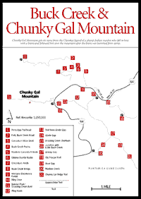
Creek and Chunky Gal Mountain Like White Oak Stamp, unique portions of Buck Creek, and Chunky Gal Mountain are classified and protected as "special interest areas" by the U.S. Forest Service. Buck Creek is a renowned site of ultrabasic rocks of great interest to those studying minerals, gems, or botany. Chunky Gal Mountain gets its name from the Cherokee legend of a plump Indian maiden who fell in love with a brave and followed him over this mountain after her parents had banished him from camp. With its long ridgetop scenic trail and noteworthy Riley Knob botanical area, Chunky Gal is considered by conservationists to be worthy of wilderness-area designation.
Chunky Gal is a long, 8-mile-high, remote, ridgelike mountain connecting the Blue Ridge and the Appalachian Trail with the Tusquittee and Fires Creek ranges. For hikers going north, there is a scenic overlook to the west from a cliff said to contain garnets and olivine. This is about 1.5 miles before Bear Gap. The trail's end south of Bear Gap [Fig. 33(19)] has most interesting vegetation in a near-original state. At Grassy Gap [Fig. 33(17)], a cove forest reaches the trail with lush herb flora including monkshood and purple-fringed orchid. A rare plant—wolfsmilk—occurs as far south as Grassy Gap, the southern limit of its growing range in the United States. Grassy Gap apparently was the crossing of the old Macon Trail [Fig. 33(18)] used by the Indians and was also a horseback mail route before the construction of US 64. It was a shortcut from Shooting Creek to the headwaters of the Nantahala River. Accessible from Muskrat Branch [Fig. 33(20)], it may, nevertheless, be difficult to find.
[Fig. 33(12)] This area covers 215 acres between 3,600 and 4,400 feet and is an outstanding example of an extensive old growth, high-altitude white oak forest. There is some cove forest and red oak ridge forest. Much of the rock in the Riley Knob area is amphibolite, which supports a rich herb flora. The knob and the Chunky Gal Ridge Trail are reached from US 64 at Riley Cove [Fig. 33(10)] or at a blue-blazed trail [Fig. 33(13)] from Glade Gap access point [Fig. 33(14)].
From this latter point, according to Allen de Hart's trail guide North Carolina Hiking Trails, one can cross US 64, turn left on old US 64, then turn right at .2 mile from Glade Gap on an old jeep road. Eventually one reaches Boteler Peak (also called Shooting Creek Bald, 5,010 feet) [Fig. 33(11)] at about 2.8 miles from Glade Gap. Here a blue-blazed trail descends northward to Perry Gap and continues on to link with the Rim Trail on the east rim of the Fires Creek Basin, a noted bear refuge.
These pine barrens in North Carolina are geologically and botanically unique. Basic magnesium-rich rocks such as olivine and dunite [Fig. 33(6)] predominate. At the first little creek [Fig. 33(4)], about .5 mile past the bridge [Fig. 33(8)], one is treated to an assortment of unusual rocks. The creek bed is littered with pieces of olivine, gabbro, chlorite schist, talc (with which one can write), and other mineral specimens—a smorgasbord of basic and ultrabasic rock. The Buck Creek Barrens contain the largest single outcrop of dunite in the Georgia and North Carolina olivine belt.
Back .1 mile is a pullout by Buck Creek, a good place to picnic. Across the creek is a "tailings pile" or mine dump. The old corundum mine shaft [Fig. 33(3)] is above it in an area of dunite rock [Fig. 33(6)]. In the late 1800s, mining for the abrasive corundum, which has a hardness next to the diamond's, was carried out throughout the corundum belt. Old roads [Fig. 33(5)] go back to Corundum Knob [Fig. 33(7)], where corundum was also mined. Here it is possible to find tiny rubies in a matrix of green stone, a type of amphibole called smaragdite.
Because of the unique plant life here, 103 of the 346 acres in the Buck Creek Barrens have been proposed as a botanical preserve. Before leaving US 64, note the presence of a normal montane deciduous forest [Fig. 33(9)]. After crossing the bridge [Fig. 33(8)], one almost immediately enters an area dominated by pitch pine with scrubby, scattered white oak. The soil moisture and temperature are such that some prairie grasses have become established. The Forest Service recognizes three unique plant communities here: 1) pitch pine-witherod, 2) the only location of pitch pine bluestem grass and prairie dropseed south of Pennsylvania, and 3) one of two sites for pitch pine–little bluestem grass in North Carolina. Two unusual wildflowers are big-leaf grass of parnassus and fringed gentian.
The weird rocks, the unusual vegetation, and the chance of panning a piece of ruby corundum out of Buck Creek make this area a prized one. After passing through the mineralized zone, one quickly reaches a fork [Fig. 33(2)]. The left-hand turn goes 2.8 miles west to the Perry Gap trailhead [Fig. 33(1)]; the right-hand turn leads to what was the old Buck Creek Lodge, which is still private property. After a return to new US 64, it is 2.3 miles to the Shooting Creek Overlook [Fig. 33(15)] (with picnic tables). The next gated road on the left goes only a short distance up Muskrat Creek [Fig. 33(20)] where, with luck, one can locate the old Macon Trail [Fig. 33(18)].
Map References: USGS 1:24,000 series: Rainbow Springs–Shooting Creek.
Read and add comments about this page