 Wormsloe
Historic Site
Wormsloe
Historic Site Located on a bluff overlooking the intercoastal waterway at the Wilmington River, Thunderbolt is the home of a large, busy marina. A picturesque drive along the waterfront's high bluff leads visitors past million-dollar yachts to several excellent restaurants that retain the flavor of a maritime community.
Essentially as old as Savannah, Thunderbolt was settled when Gen. James Edward Oglethorpe determined the bluff was of military strategic importance when he arrived in 1733. Thunderbolt has one of the more memorable names of any town in Georgia. According to Oglethorpe, the town was named after "a rock which was here shattered by a thunderbolt, causing a spring to gush from the ground, which continued ever afterward to emit the odor of brimstone." Oglethorpe built a settlement and fort here, the first of several through the years. By 1734, Thunderbolt was ready to defend Savannah with a hexagonal palisade and a battery of four cannons. During the Revolutionary War, the leader of the French forces, Charles-Henri Comte d'Estaing, used Thunderbolt as his base of operations during the unsuccessful siege of Savannah. During the Civil War it was the site of a battery and a garrison.
A casino, built in 1875 on the land bordering the river, became one of the most popular recreation spots in the Savannah area. It burned in 1930, and today Thunderbolt Marina operates in the former location.
For many years, Thunderbolt was home to fishing families, who worked the coastal waters and moored their fishing and shrimp boats at the river. Today, the fishing-supported Thunderbolt community is disappearing as gentrification pushes through the area, and million-dollar yachts are much more common than shrimp boats.
River Road, which follows the banks of the Wilmington River between Bonaventure Cemetery and Thunderbolt, is a scenic route on the southern side of US 80 (Victory Drive) that features the marsh, yachts, shrimp boats, and marina toward the water and some locally famous restaurants on the other side. Locals appreciate their Live Oaks enough to build their road around a huge one as you enter the town.
Palmer-Johnson Marina. 3124 River Road, Thunderbolt. If you love big, expensive yachts, you will find the biggest and most expensive on the Georgia coast right here. Nearby, the luxury vessels are bought and sold, built and rebuilt, furnished and refurbished to the tune of thousands, if not millions, of dollars in what is considered the premier repair yard in the southeast. (912) 356-3875. Downstream and on the other side of the river is Savannah Bend Marina, a full-service marina offering wet and dry storage, gas and diesel fuel, hoists and docks, bait and tackle, indoor boat storage, and a restaurant. (912) 897-4956.
The view of the Wilmington River and ready access to daily fresh seafood traditionally made Thunderbolt a great location for seafood restaurants.
Teeple's. 2917 River Drive, Thunderbolt. This is reputably the oldest "shell-your-own" restaurant in the Savannah area, featuring local blue crab, shrimp, oysters, and clams. Charlie Teeple started Teeple's in 1976, and the third-generation Thunderbolt family still runs it today. The restaurant is such a fixture in the community that when it had a fire a few years back, locals still were dropping by to pick up steamed crabs to go. Some say this place invented the hole-in-the-middle-where-you-dump-your-shells table, but no one can prove it. Best when the seafood is in season. Nice view of the marsh and river. Open Monday through Thursday for dinner and Friday through Saturday for lunch and dinner. Moderate. (912) 354-1157.
The River's End Restaurant and Lounge. 3122 River Drive, Thunderbolt. For a classier dining experience in Thunderbolt, The River's End located near the Palmer-Johnson Marina is an excellent choice. A local favorite for more than 30 years, the restaurant overlooks the Intracoastal Waterway and features local seafood and charbroiled steaks. Open at 5 p.m. for dinner only. Closed Sundays. Moderate. (912) 354-2973.
The Isle of Hope National Historic District, with its expansive Live Oaks, magnolias, and azaleas, is as charming as its name implies. But it is somewhat false advertising because Isle of Hope is not really an island, but a sandy peninsula with a high bluff looking over to Skidaway Island across the Intracoastal Waterway at Skidaway Narrows and the Isle of Hope River. Whether on foot, bike, or car, visitors can view Isle of Hope's beautiful antebellum homes and old summer cottages in this picturesque community, which has been used many times as a setting for movies.
The Isle of Hope Methodist Church, located 412 Parkersburg Road, was built in 1859 prior to the start of the Civil War. The grounds were used as a Confederate battery, consisting of two 8-inch Columbiads and two 32-pound cannon. The church was used as a Confederate hospital during the Union occupation of the area in 1864, and the pews, still in existence, were used as beds. Carvings in the pews made by patients are still visible today. General Sherman, who didn't have much respect for organized religion, melted the church bell for cannonballs. A gallery in the back was for slaves. The historic cemetery holds the graves of 33 Confederates from Effingham County.
First settled in 1736 by Noble Jones, John Fallowfield, and Henry Parker, the area was recognized as an important defensive outpost on the young colony's inland waterway south from Savannah. Noble Jones's Wormsloe Plantation was the site of a fort that defended Savannah from Spanish attack until 1742. During the 1800s, the area attracted more residents and a small community known as Parkersburg was established. The area was fortified during the Civil War, but saw little action. After the Civil War, Isle of Hope became a popular resort community, with daily train service in the 1870s. Where the river met the railroad was Barbee's Pavilion, which became world renowned in the 1920s.
Historic Wormsloe Plantation (see below); Bethesda, the oldest still-operating orphanage in America; and the Isle of Hope Marina are located on Isle of Hope. All these attractions are located a few miles away from each other and can be reached by car or bike.
Bethesda Orphanage was conceived by Charles Wesley and James Oglethorpe, and the idea was made reality by the Reverend George Whitefield, who arrived in Georgia in 1738. He received a grant of 500 acres in 1739, and in 1740 he opened the first orphanage in the New World. The name is Biblical in origin and means "house of mercy." Governor John Milledge and Gen. Lachlan McIntosh both were raised by the orphanage. The Rev. Whitefield was famous for his fund-raising sermons, working tirelessly for 32 years to raise funds for the orphanage, and preaching over 18,000 times. One sermon even moved the penny-pinching Ben Franklin to give money to the orphanage, which Franklin wrote about in his famous autobiography. Whitefield Square in the Savannah Historic District is named in his honor.
The orphanage is still in operation today. Bethesda's main support comes from The Union Society, which was originally formed in 1750 by a "union" of a Catholic, Protestant, and a Jew. Some claim that it is the oldest charitable organization in America. Bethesda is located at 9520 Ferguson Avenue. Phone 351-2040.
The Isle of Hope Marina, 50 Bluff Drive, is a good place to book a ride to Wassaw National Wildlife Refuge. Phone (912) 354-8187.
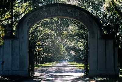
Wormsloe
Historic Site [Fig. 6(4)] The most breathtaking driveway in the entire state belongs to Wormsloe Plantation, which features an impressive 1.5-mile avenue lined with approximately 400 Live Oaks. A state-operated historic site, Wormsloe Historic Site features hiking trails through the maritime forest, the oldest estate in Georgia, one of the last architectural remnants of Savannah from the Oglethorpe era, Confederate fortifications, and an excellent museum telling the history of colonial Georgia.
The hiking trail takes one down to the tabby ruins of Wormsloe, which sits on a bluff overlooking Jones Narrows. A short spur trail takes the hiker to the Jones Narrows and the original gravesite of Noble Jones, his wife Sarah, and their youngest son, Inigo. Today, they are buried in Bonaventure Cemetery. In colonial days, this channel was the main inland water route between Savannah and settlements to the south. Dredging for the Atlantic Coastal Waterway altered the flow in the marsh, clogging the channel with silt. Spartina marsh now fills much of the waterway.
Jones's Fort was built in a strategic location to control shipping traffic and defend against possible attacks by the Spanish from the south. It was one in a series of forts built by Oglethorpe to protect the 13th colony from the Spanish. Other forts included Fort Argyle where the Ogeechee and Canoochee rivers meet; Mount Venture on the Altamaha River; Fort Darien and Barrington in McIntosh County; Bachelors Redoubt; Fort Frederica and Fort Saint Simons on St. Simons Island; Carrs Fort in Brunswick; Fort Saint Andrews and Fort Prince William on Cumberland; and Amelia Fort on Amelia Island. These forts were put to use during the War of Jenkins' Ear (1739–1743) when Spaniards invaded Georgia before being beaten by Oglethorpe in the Battle of Bloody Marsh on St. Simons in 1742.
On the 1-mile long, interpretive hiking trail, you will see cabbage palm, red cedar, live oak, and pines. Spanish bayonet, dogwood, azaleas, and ferns are abundant. Deer are very frequently spotted on the Wormsloe property. More careful and quiet observation is needed to see raccoons, opossums, and possibly bobcats. Small bridges cross tidal creeks, where you may see wading birds such as egrets, herons, and ibis in the marsh. During the right season, migratory songbirds are found in the forest. Plaques display reproductions done by eighteenth century naturalist and artist Mark Catesby. Insect repellant is recommended.
Massive old-growth pines that dominated Wormsloe were destroyed in 1974 when a southern pine beetle epidemic swept through the property. The Georgia Forestry Commission successfully fought the pine beetles by removing the trees, but the insect effectively changed the forest, allowing more sunlight to reach the forest floor, prompting dense understory growth.
The museum has artifacts, exhibits, and an audiovisual presentation that tells the story of the coastal colonial plantation of Noble Jones and his family. Jones, a physician, carpenter, surveyor, and military man, was one of the original settlers of Georgia, coming with Gen. James Edward Oglethorpe in 1733. In 1736, Jones leased from royal Trustees 500 acres on the Isle of Hope approximately 10 miles south of Savannah. In 1739, he started building a five-room, fortified tabby house incorporated into a rectangular tabby wall with four bastions. Construction was interrupted twice during the War of Jenkins' Ear. By 1745, Jones returned and completed his home. He received the property in 1756 by a royal grant conveying ownership.
The 750-acre plantation became well known for its experimental horticultural efforts in the young colony, with rice, indigo, cotton, and silk grown here. The silk-production effort—silk worms on mulberry trees—is the source of the plantation's original name: Wormslow. In 1765, famed naturalists John and son William Bartram visited Wormslow to learn about Jones's plant experimentation, and William wrote in his famous book Travels about the unusual fruits he found growing here such as oranges, figs, pomegranates, peaches, and apricots.
Jones was a renaissance man. He helped found the colony of Georgia. He commanded a company of Marines who patrolled the inland water route in a guard boat to defend Savannah from any attack from the Spanish. A middle-class carpenter from England, he served as soldier, constable, Indian agent, physician, and treasurer of the colony, Royal Council member, and Justice of the Province. He built the first lighthouse on Tybee Island, and as surveyor he laid out the towns of New Ebenezer and Augusta.
 Noble
Jones, a Tory, died in 1775 before the American Revolution. Surviving him was
his son, Noble Wimberly Jones, who supported the Patriot cause and was captured
by the British. Noble Wimberly Jones was 10 when he arrived with his father
aboard the Anne in 1733. After the war, he practiced medicine in Savannah
until his death in 1805. Surviving him was his son, George Jones, who was an
excellent businessman and enlarged the family fortune. George Jones abandoned
the tabby home and built a new one in 1828, where he lived until he died in
1838. His son, George Frederick Tilghman Jones, changed his name to George Wymberley
Jones DeRenne to avoid confusion with another prominent George Jones in Savannah.
He also changed the name of Wormslow to its current spelling of Wormsloe. It
is believed he was the richest man in Savannah.
Noble
Jones, a Tory, died in 1775 before the American Revolution. Surviving him was
his son, Noble Wimberly Jones, who supported the Patriot cause and was captured
by the British. Noble Wimberly Jones was 10 when he arrived with his father
aboard the Anne in 1733. After the war, he practiced medicine in Savannah
until his death in 1805. Surviving him was his son, George Jones, who was an
excellent businessman and enlarged the family fortune. George Jones abandoned
the tabby home and built a new one in 1828, where he lived until he died in
1838. His son, George Frederick Tilghman Jones, changed his name to George Wymberley
Jones DeRenne to avoid confusion with another prominent George Jones in Savannah.
He also changed the name of Wormslow to its current spelling of Wormsloe. It
is believed he was the richest man in Savannah.
Wormsloe was the site of Confederate earthworks known as Fort Wimberly during the Civil War. The breastworks and the large earthen battery are still visible. Union troops arrived at the fort after the fall of Savannah and vandalized the house.
Eventually, the property fell into decay, and in 1972, Jones's descendants donated 822 acres to The Nature Conservancy, which transferred the property to the State of Georgia. The 1828 house and 65.5 acres are still owned by the family.
A colonial life area is located just off the nature and interpretive trails. Structures here simulate the small wattle and daub huts that served as quarters for Jones's Marines, indentured servants, and slaves. Living history programs are held here, where costumed staff display skills and crafts necessary to early settlers of coastal Georgia.
Read and add comments about this page