 Fort
Pulaski National Monument Fort
Pulaski National Monument
Fort
Pulaski National Monument Fort
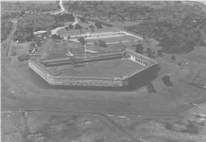
Pulaski National Monument [Fig. 9(2)] Fort Pulaski National Monument, located on Cockspur Island in the Savannah River before you reach Tybee Island, is one of the finest national parks in the U.S. Whether you are interested in Civil War history or want to walk the island's nature trails, Fort Pulaski is great for families and exciting to visit. While its historic value is evident, its natural communities are also worth the visitor's attention. The park is a stop on the Colonial Coast Birding Trail established by the Georgia Department of Natural Resources.
President James Madison commissioned the huge brick fort in 1816 as a reaction to the War of 1812 as one of the Third System of coastal fortifications, created when the U.S. Congress decided that the new nation needed a better system of forts to protect its harbors and cities. The British during the War of 1812 successfully attacked Washington, D.C. and burned the White House.
Pulaski was not the first fort to be built on Cockspur Island. Fort George, a palisaded blockhouse, was constructed on Cockspur Island in 1761 by John G.W. DeBrahm. Its primary purpose was to defend Savannah from the Spanish in St. Augustine. When hostilities with the Spanish died down, it remained in service as a quarantine and customs house. When the Revolutionary War broke out in 1776, Patriots abandoned and dismantled the fort. Its exact location remains a mystery. British warships seized the island and it became a refuge for Royalists who supported the British cause. One refugee was Sir James Wright, the popular royal governor of Georgia, who escaped from house arrest on February 11, 1776 in Savannah and resided here and on British man-of-wars until he fled to Nova Scotia for three-and-a-half years. After the war, Wright returned to Tybee to sail with Tories back to England.
Fort Greene was built on Cockspur Island from 1794–1795 to provide defense for the new republic. In September 1804, the island was pounded by one of the most powerful hurricanes in history, obliterating all traces of the fort. According to a Charleston newspaper, the hurricane moved a 4,000-pound cannon 40 feet. The site of Fort Greene is believed to be a hammock southeast of Fort Pulaski.
Construction on Fort Pulaski began in earnest in 1829 on Cockspur Island, a marshy delta island that was chosen for its strategic location at the opening of the Savannah River. The island's name is derived from the spur-shaped reef that juts out into the northern channel of the sound. The marshy island is also known as Long Island. The island's first recorded name was Peeper Island, given to it by Gen. James Edward Oglethorpe in 1733, because as ships sailed around Tybee Island's northern shoulder, they saw the island "peeping" at them.
The fort is named for Count Casimir Pulaski, the Polish hero of the American Revolution who lost his life in the unsuccessful siege of Savannah in 1779. He died leading the French and American attack on the British who had possession of Savannah.
Designed by Gen. Simon Bernard, the structure was built by Army Corps of Engineers Captain J.F.K. Mansfield with 25 million bricks in 18 years at a cost of $1 million. A series of dikes, worked on by recent West Point graduate and Second Lieutenant Robert E. Lee from 1829–1831, was constructed to produce a protective moat and keep the fort and island dry. By the end of 1860, as southern secessionist and northern abolitionist emotions were reaching the boiling point, the fort had yet to be garrisoned or outfitted with a full complement of artillery.
On January 3, 1861, two weeks after South Carolina had seceded from the Union and one week after U.S. troops had occupied Fort Sumter in Charleston Harbor, Georgia militiamen seized the Federal fort. They were under orders from Governor Joseph E. Brown, even though Georgia had not yet seceded from the Union. Brown was acting to protect Savannah, a city of 20,000 that at this time was one of the most prosperous seaports in America, trading cotton, timber, and naval stores.
After the famous Georgia Secession Convention at the state capital in Milledgeville on January 19, 1861, the fort transferred to Confederate control. By the end of April, 11 southern states had left the Union and were at war with the northern states. President Abraham Lincoln ordered the naval blockade of the South as a part of his master strategy to starve and strangle the South. On November 7, 1861, U.S. forces struck Port Royal Sound, and seized Hilton Head. From here, Federal forces established a headquarters where they planned actions against Fort Pulaski and the rest of the South Atlantic coast. On November 10, 1861, intimidated Confederate forces abandoned Tybee Island, and U.S. troops under Engineer Capt. Quincy A. Gillmore established a base of operations on the island.
What happened next changed the history of modern warfare. Gillmore believed he could bombard the fort from the island with the new experimental "rifled" cannon. He and his 1,100 men spent two months dragging 36 mortars and smoothbore and rifled cannon across the marsh to establish 11 Union batteries from which to fire on the fort. Much of the backbreaking work occurred at night to hide their plans.
Fort Pulaski was commanded by Col. Charles H. Olmstead. Aware of the Federal presence on the island 1 mile away, the young commander believed the distance from Tybee to the fort protected it from serious harm. Most heavy ordnance of the day was effective at half that distance. In fact, Gen. Robert E. Lee, who had more than a passing acquaintance with the fort, told him the Federal gunners could "make it pretty warm for you here with shells, but they cannot breach your walls at that distance."
 Lee
was wrong. On April 10, 1862, Gillmore asked for the Confederates to surrender
the fort. When Olmstead refused, the Federals opened fire. The rifled cannon
were devastatingly accurate, destructive, and effective, breaching the 7.5-foot-thick
walls of the southeast angle of the fort and threatening the main powder magazine.
Five of the 10 rifled guns used by Federal troops were 30-pound Parrott guns,
which had an effective range of 8,453 yards—much longer than conventional
smooth-bore artillery. The technical innovation that made the difference were
spiraled or rifled grooves on the inside of the cannon barrel and an expansion
skirt or ring around the end of the projectile that gave the bullet-shaped shell
a spin when fired. The spin gave the projectile increased range, accuracy, and
penetrating power that doomed the Confederates inside Fort Pulaski. Olmstead
surrendered the fort and his 384 men only 30 hours after the bombardment began,
writing, "Guns, such as have never before been brought to bear against
any fortification, have overpowered me." Gillmore was a northern hero and
was breveted a brigadier general. The rifled cannons on Tybee Island ended the
age of masonry forts across the globe. Once thought to be nearly invincible,
brick and masonry forts were now obsolete, and rifled cannons became a technical
innovation that continues to be used today by the big guns on battleships.
Lee
was wrong. On April 10, 1862, Gillmore asked for the Confederates to surrender
the fort. When Olmstead refused, the Federals opened fire. The rifled cannon
were devastatingly accurate, destructive, and effective, breaching the 7.5-foot-thick
walls of the southeast angle of the fort and threatening the main powder magazine.
Five of the 10 rifled guns used by Federal troops were 30-pound Parrott guns,
which had an effective range of 8,453 yards—much longer than conventional
smooth-bore artillery. The technical innovation that made the difference were
spiraled or rifled grooves on the inside of the cannon barrel and an expansion
skirt or ring around the end of the projectile that gave the bullet-shaped shell
a spin when fired. The spin gave the projectile increased range, accuracy, and
penetrating power that doomed the Confederates inside Fort Pulaski. Olmstead
surrendered the fort and his 384 men only 30 hours after the bombardment began,
writing, "Guns, such as have never before been brought to bear against
any fortification, have overpowered me." Gillmore was a northern hero and
was breveted a brigadier general. The rifled cannons on Tybee Island ended the
age of masonry forts across the globe. Once thought to be nearly invincible,
brick and masonry forts were now obsolete, and rifled cannons became a technical
innovation that continues to be used today by the big guns on battleships.
Fort Pulaski remained under Federal control until the end of the Civil War. On April 29, 1865, upon receiving the news that Confederate Gen. Robert E. Lee had surrendered, Union troops fired 200 guns from the ramparts, symbolically marking the end of Lee's 35-year military career that had begun on Cockspur Island. A few weeks later, Confederate President Jefferson Davis was captured in Irwinville, Georgia, as he tried to flee from Union cavalry. He spent the night as a prisoner aboard a ship in the lee of Cockspur Island as he was being transported to Fortress Monroe.
By 1880, only a caretaker and lighthouse keeper remained at the fort. Eventually, the fort was completely abandoned until October 13, 1924, when the 537-acre site was made a national monument by presidential proclamation. In 1933, serious restoration began on the fort. Today, it is in excellent condition, still bearing the marks of the Federal bombardment almost 140 years ago.
The fort is fascinating to tour. A short movie at the visitor center explains what visitors are about to see. Beautiful views of the marsh from the fort's walls belie the buggy boredom, disease, and general misery troops endured while serving at the fort. Try to imagine the strenuous work involved in firing one of the heavy guns—or the dread in waiting for a responding, incoming shell. The entire perimeter of the fort offers much to see, including the damaged wall still pocked with craters and holding shot from Union artillery, to the cistern system that trapped more than 200,000 gallons of fresh water for the fort's thirsty troops. Other highlights include the surrender room and the northwest magazine that held 40,000 pounds of gunpowder, and the earthen demilune system constructed from 1872–1875 based on concepts learned right here during the Civil War.
Perhaps the most impressive engineering feat of the fort is largely unseen. Building an enormously heavy masonry fort on unstable marsh required elaborate underpinnings. At the southwest bastion, an area has been left in original condition to display various construction details of the fort. Brick arches under the terreplein carry weight to counter arches in the floor that are supported by pilings that are driven 70 feet into the mud of the island. The quality of the engineering is obvious by the still-straight lines of bricks at the water edge of the fort's moat.
Other features worth noting at Fort Pulaski National Monument include nature trails, Battery Hambright, and the John Wesley Memorial.
The wildlife found on Cockspur fascinated even Second Lieutenant Robert E. Lee, who made drawings of flora and fauna he found here while constructing the dike system. While the island's uplands are mostly man-made from dredge material from the Savannah River and kept artificially dry by the dike system, a mix of plant communities provide proof that in the coastal environment, given a chance, vegetation will start to take hold on any piece of high ground.
 Cockspur
historically was a low-lying coastal island with a few high spots that was frequently
washed over by storm tides, killing plants that had little tolerance to salt
water before they had a chance to become established. The draining of the island
and the addition of soil has added more high ground, leading to a more ecologically
diverse island. Today, along with the southern red cedar (Juniperus virginiana)
hammocks, Spartina, and salt flats that would have been found in Robert
E. Lee's day, you also find new species such as sugarberry trees, recognized
by their warty bark; shining or winged sumac, identified by the narrow leaves
that grow along the step; and yaupon holly (Ilex vomitoria). The island
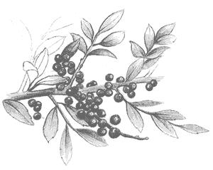
is covered with climbing vines, including muscadine
(Vitis rotundifolia), which produces an edible grape-like purple fruit
that is made into jellies and wine. Several species of Smilax and Virginia
creeper (Parthenocissus quinquefolia) also grow here.
Cockspur
historically was a low-lying coastal island with a few high spots that was frequently
washed over by storm tides, killing plants that had little tolerance to salt
water before they had a chance to become established. The draining of the island
and the addition of soil has added more high ground, leading to a more ecologically
diverse island. Today, along with the southern red cedar (Juniperus virginiana)
hammocks, Spartina, and salt flats that would have been found in Robert
E. Lee's day, you also find new species such as sugarberry trees, recognized
by their warty bark; shining or winged sumac, identified by the narrow leaves
that grow along the step; and yaupon holly (Ilex vomitoria). The island
is covered with climbing vines, including muscadine
(Vitis rotundifolia), which produces an edible grape-like purple fruit
that is made into jellies and wine. Several species of Smilax and Virginia
creeper (Parthenocissus quinquefolia) also grow here.
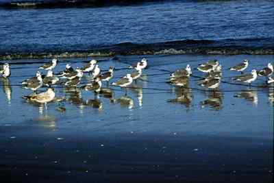
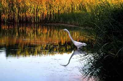
The high ground has stimulated the growth of a variety of plants that produce fruit and other food for wildlife. Many birds depend on the high-energy content of the berries, which ripen in time for the fall flight of migrants. Look for painted buntings, white-eyed vireos, and yellow-billed cuckoos. Common mammals found on the island include marsh rabbits, gray squirrels; rice, cotton and black rats; raccoons, minks, and white-tailed deer.
The dikes on the island trap fresh water important to wildlife, and frogs and the occasional alligator are seen and heard in the long canals. Frogs and toads found on the island include the southern toad, Eastern narrow-mouthed toad, green treefrog, squirrel treefrog, southern cricket frog, and southern leopard frog. Snakes include the Eastern cottonmouth, Eastern diamondback rattlesnake, rough green snake, corn snake, yellow rat snake, Eastern kingsnake, and southern black racer. Look for lizards sunning themselves such as the green anole, ground skink, southern five-lined skink and Eastern glass lizard.
Fish living in the canals include gray mullet, ladyfish, Atlantic mummichog, sheepshead minnows, sailfin molly, mosquitofish, and black seabass larvae.
The three interconnecting trails, which total three miles, are worth doing. All are nature trails, but not all are called nature trails. The longest, the 1.8-mile dike system trail, is great to experience on a bike, with many views of the surrounding marsh and glimpses of shrimp boats in Tybee Roads. Riding along the top of the dike system is a great way to appreciate the engineering efforts needed to build Fort Pulaski. Located halfway out into the marsh between the fort and Cockspur Beacon was Fort George. Today you may see a great blue heron, marsh rabbit, raccoon, or an Eastern diamondback snake. All are seen on Cockspur Island.
The 0.5-mile picnic trail (one-way), beginning across from the visitor center at the northern end of the parking lot and ending at the picnic area, takes the hiker through a maturing maritime forest consisting of alkaline-loving southern red cedar and cabbage palms.
The 0.75-mile nature trail, a loop that connects up with the picnic trail, takes the hiker through yaupon shrub and mixed shrub-juniper plant communities. Interesting plaques, placed by a local Boy Scout troop, highlight natural and human history of the area. A particular emphasis is on the medicinal qualities of the plants, with notes and recipes from Francis Porcher, who wrote The Medical Botany of the Southern States in 1889. Yaupon holly was used by Native Americans as an emetic, creating what they called the "black drink," which according to Porcher was "like opium, it excites the torpid and languid, while it calms the restless and introduces sleep."
Part of the nature trail features a religious site important to Methodists and a Spanish-American War era battery. The Wesley Memorial is where the founder of Methodism, John Wesley, preached his first sermon in the New World on February 6, 1736. Wesley, 1703–1791, spent 21 months spreading the gospel in scattered settlements in Georgia before returning to England in 1737 after a falling out with his parishioners.
 Battery
Hambright, located near the memorial, was part of the Fort Screven coastal fortification
system intended to protect Savannah shipping lanes in anticipation of hostilities
from Spain, which had a stronghold in its colony of Cuba. The battery, located
inside a large protective mound of dirt, is one of six built for Fort Screven,
and the only one on Cockspur Island. The battery is named for Horace George
Hambright, a young officer who died in 1896 on the North Dakota frontier during
the Indian wars. Construction started in June of 1899 after the Spanish-American
War had ended, and the battery consisted of two 3-inch rapid-fire gun placements.
Battery
Hambright, located near the memorial, was part of the Fort Screven coastal fortification
system intended to protect Savannah shipping lanes in anticipation of hostilities
from Spain, which had a stronghold in its colony of Cuba. The battery, located
inside a large protective mound of dirt, is one of six built for Fort Screven,
and the only one on Cockspur Island. The battery is named for Horace George
Hambright, a young officer who died in 1896 on the North Dakota frontier during
the Indian wars. Construction started in June of 1899 after the Spanish-American
War had ended, and the battery consisted of two 3-inch rapid-fire gun placements.
Stretching across the Savannah River from the battery was a submarine minefield. It was electronically controlled by a mining casemate built in 1895 and located under a mound of earth near Fort Pulaski. The mines were anchored to the bottom of the river, but floating above them was a buoy. When passing ships struck the buoy, an electronic signal was sent to the casemate. The two or three men working in the casemate would determine if the ship was friend or foe. If the ship was an enemy, more than 500 pounds of explosives could be detonated.
At the end of a side trail is the North Pier, where supplies and men were brought in to build Fort Pulaski. Here the visitor is treated to an excellent view of the Savannah River and surrounding marsh.
[Fig. 9(3)] Cockspur Beacon, also known as Little Tybee Light and South Channel Light, is one of Georgia's five remaining lighthouses. The Savannah River has two entrances or two channels, the north and the south. Cockspur Island Beacon marked the southern entrance and a twin lighthouse on Oyster Bed Island, no longer in existence, marked the northern entrance. First erected in 1849, and then rebuilt with Savannah grey brick on the original foundation in 1857, Cockspur Beacon lost importance in 1879 when many ships started using the northern channel and was deactivated in 1909 when all ships switched to using the northern channel of the Savannah River. Today, the southern channel is much more silted in than the northern channel, which is dredged. Standing 46 feet tall, with a 16-feet base, the lighthouse is situated on an oyster shell bed off the southeastern end of Cockspur Island, where it continues to be used as a daymark.
For such a small structure, the lighthouse has seen a lot of action. During the 1857 reconstruction, a keeper's house and dock facilities were added, but lightning struck the house in 1880 and in 1881 a hurricane blew it away. The lighthouse was in the line of fire when Union batteries fired upon Fort Pulaski on April 10, 1862, but luckily was not hit. Tragedy struck the second lighthouse keeper, Cornelius Maher, who drowned at the lighthouse when his boat capsized in 1853. The fourth keeper, Thomas Quinfiven, died of yellow fever after only four months of service. In 1881, George Washington Martus became the lighthouse keeper. His sister, Florence, known as the "Waving Girl," was born on Cockspur Island and became famous for greeting every ship that passed by her home on Elba Island. She is immortalized in bronze with a statue of her on River Street on the waterfront in Savannah.
In its heyday, the beacon used a sixth order Fresnel lens, which was illuminated by an oil lamp that burned 90 gallons of sperm oil a year. Sixth order Fresnel lenses are the smallest, and mark rivers or channels. Abandoned by the U.S. Coast Guard in 1949, the beacon fell under the control of the National Park Service and today is the responsibility of Fort Pulaski National Monument. Open to the public, the lighthouse is generally surrounded by water and not accessible from Fort Pulaski. Caution: Be very careful about visiting this lighthouse. Approached at low tide by boat, adventurous souls can brave the slippery and sharp oyster shells at the base to see the beacon up-close. A slippery and crumbling internal staircase can be climbed at your own risk to the top of the lighthouse.
The old beacon is in need of restoration work and perhaps someday in the future preservation funds can be allocated to preserve this historic structure.
[Fig. 9] This is one of the best biking trails on the coast. A rails-to-trails conversion, the 5.8-mile trail follows the length of McQueens Island toward Savannah, following the Savannah-Tybee railroad bed. Accessed at the entrance of Fort Pulaski or at the trail's halfway point 3 miles west of the entrance on US 80, the trail consists of crushed oyster shell and limestone, which makes a nice surface for a mountain or beach bike. In 1887, Daniel G. Purse and John J. McDonough of the Savannah and Atlantic Railroad built the Savannah-Tybee Railroad, an important part of the area's history, which linked Savannah with downtown Tybrisa Pavilion. The Central of Georgia Railway purchased the railroad in 1890 and operated it until 1933, when it was put out of business by the automobile highway that linked the island with the coast.
 In
history books, the hour-long rail trip is recounted with no small amount of
nostalgia, telling how vacation-bound travelers, excited to get to Tybee, were
kept cool even in the middle of summer with fresh marsh breezes blowing in through
the windows of the train. Train tickets cost 18 cents for adults, 10 cents for
children.
In
history books, the hour-long rail trip is recounted with no small amount of
nostalgia, telling how vacation-bound travelers, excited to get to Tybee, were
kept cool even in the middle of summer with fresh marsh breezes blowing in through
the windows of the train. Train tickets cost 18 cents for adults, 10 cents for
children.
Today, abandoned railroad ties, pushed off the banks into the adjacent marsh, lie ignored and forgotten. But hikers and bikers can't help but be impressed with the strenuous efforts that got them here in the first place or the beautiful railroad journey railroad passengers must have enjoyed in the Roaring Twenties.
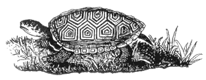
McQueens Island is defined by the south channel of tLazaretto Creeker to the north, and tidal rivers Lazaretto Creek, Oyster Creek, Bull River, and St. Augustine Creek to the south. Lined with cabbage palm trees, southern red cedar, and live oaks, a hiker or biker will be treated to views of salt marsh on one side and the Savannah River on the other. Plant communities include salt marsh, high marsh, salt pan, and mixed shrub and juniper. The dominant plant in the lower elevations of the Holocene marsh, much of it growing to 6 feet in height, is Spartina alterniflora. Wildlife is plentiful. As fiddler crabs scurry out of your way, look farther down the path and you may see the shy and elusive willet (Catoptrophorous semipalmatus) crossing the road into the marsh. Hundreds of willets nest in the area. Redwing blackbirds, great egrets, and great blue herons are commonly seen along the trail, as are Carolina diamondback terrapins, raccoons, bobcats, and an occasional Eastern diamondback rattlesnake.
Wide enough for two bikes to pass each other comfortably, the well-maintained pathway has exercise stations for joggers, picnic tables for families, and wooden platform overlooks for classes or photographers. Plaques along the way give distances and illustrate fauna commonly found in the salt marsh. At the western end of the trail, you find a beautiful live oak festooned with Spanish moss and more portable toilets. The halfway access point also has portable toilets and a paved path to a wooden deck that overlooks the marsh. Motorized vehicles are prohibited on the trail.
Read and add comments about this page