[Fig.
23] When relentless gales of a northeaster pound the coast for days on end,
people who live on Virginias upper Eastern Shore are glad that 37-mile-long
Assateague Island lies off the coast to protect them from the fierce Atlantic.
Assateague is just one in a chain of barrier islands along the Atlantic seaboard
that are built as wave action piles up sand from the ocean floor.
What is not apparent is that islands such as Assateague are not stationary, but dynamic. Just as waves and water build the island, so they also are constantly moving it around. In addition to daily tidal movements, there are seasonal movements as well. Gentle summer waves bring sand from offshore sandbars, forming wide beaches. In winter, waves pack more energy and the pounding on the beaches makes them more narrow as sand is carried back out and deposited on the sandbars. Major storms can bring in heavier grains of black sand made up of minerals that make the beach look dirty. Time is required to restore the smaller and lighter grains of white sand that vacationers desire.
The natural movement of barrier islands poses no problem until humans decide to put hotels, swimming pools, and highways on them. Then, somewhere down the road, it becomes necessary to build sea walls, to shore up dunes in front of buildings by pumping in sand from offshore, or to build rock jetties to keep the island from continuing to transport itself somewhere else. What engineers have found, though, is that for every mechanical thing done to make the island stay put, there is a reaction somewhere else. For instance, the rock jetties built on the southern end of the next barrier island to the norththe one that holds Ocean Cityhave caused wide beaches to pile up there. But, in turn, the adjacent northern end of Assateague is eroding severely and migrating toward the mainland at a much faster speed than it once did.
What is best? Should moving beaches be bent to the will of man or should they be left to time and nature? The problem is a sticky one, and there are no easy solutions. Heated discussions occur at every level of government over what should be done and who should pay for it.
At Assateague, the erosion has allowed storms to overwash the dunes. Consequently, the modern Toms Cove Visitor Center has already had to be moved three times and the parking lot redesigned. On other more developed islands, damage can be far more costly as high-rise hotels built too close to the surf are threatened and beach cottages collapse one by one into the sea with each passing storm.
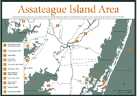
[Fig. 23(1)] Most of this long barrier island that extends from just south of Ocean City, Maryland, to Virginias upper Eastern Shore near Chincoteague is part of the 18,000-acre Assateague Island National Seashore, managed by the National Park Service and the U. S. Fish and Wildlife Service. The island is accessible from the mainland from both the Maryland end and the Virginia end (for the Maryland end), but there are no roads on the island that connect the north and south ends. A fence on the state line keeps even the wild ponies that roam the island from mixing.
Toms Cove Visitor Center on the Virginia part of the island is located just west of the oceanfront dunes on the eastern side of Chincoteague National Wildlife Refuge. In addition to exhibits, maps, and publications, children will enjoy learning about maritime life and viewing aquariums. The 0.25-mile Toms Cove Nature Trail loop is near the visitor center. Toms Cove Hook on the southern end of the island is closed during the nesting season of the endangered piping plover between March 15 and August 31. Beachcombing is always fun, but only occasionally turns up large shells that have not been pounded into pieces by the Atlantic. Surf fishing, crabbing, and clamming are other popular Activities.
[Fig. 23(2)] Anyone who has wondered what is done with revenue from the sale of duck stamps would enjoy a visit to Chincoteague National Wildlife Refuge. Before the 1900s, the flocks of ducks, geese, and other waterfowl migrating along the Atlantic Flyway seemed too endless ever to become imperiled. But in the early part of the century, their numbers took a startling dive. Conservationists became alarmed as more and more wetlands were drained for farming or developments. Feathers and plumes were used to decorate ladies hats, and game management was in its infancy. In short, wildfowl needed a hand.
In 1943, funds collected from the sale of duck stamps bought a magnificent refuge where the migrating birds could feed and rest. Although the birds and animals come first, people who enjoy watching and learning about them also benefit.
Chincoteague refuge is located on the southern end of 37-mile-long Assateague Island, within the boundaries of Assateague Island National Seashore, just east of the island and village of Chincoteague. Among the thousands of birds that come here, the snow geese (Chen caerulescens), with their beautiful white plumage and black primary wing feathers, are among the favorites.
Hikers have 15 miles of trails to explore, and half of those are paved for bicycling and wheelchairs. The 3.2-mile, paved Wildlife Loop gives hikers and bikers access to Snow Goose Pool and Swan Cove. Vehicles are permitted on the loop between 3 p.m. and dusk. The waterways and ponds beside the road always hold a snowy egret, or the elegant great blue heron, or perhaps a flock of Canada geese. Photographers who have not experienced the bonanza of subject matter may find themselves dashing back to the car for more film.
Bird watchers armed with scopes can identify sea ducks such as as oldsquaws and scoters, or puddle ducks such as widgeons, pintails, and mallards. In spring, where a knot of onlookers has gathered, there are sure to be a couple of baby foxes playing, or maybe a group of tiny raccoons peeking through the grass fronds.
In addition to the Wildlife Loop, other hiking opportunities include the 1.6-mile Woodland Trail loop (walking and bicycling allowed) and the 0.25-mile (one-way) Lighthouse Trail to the photogenic Assateague Lighthouse, emerging from the wax myrtles. Built in the 1860s, this tower lighthouse with its alternating red and white rings still operates with a flashing light. The pine forests of the refuge hold white-tailed deer and the much smaller Sika deer. Sikas, which are actually an Oriental species of elk, were released on a Chesapeake Bay island in the early 1900s. They were released on what became Assateague Island in the 1920s. Wild ponies also roam the island and are a common sight as they graze the salt marshes. Sometimes, like restless children just let out of school, they may take a notion to gallop wildly along the waters edge of Chincoteague Channel, ears laid back in mock rage, splashing and nipping one another. Interpretive programs that explain the barrier island natural and cultural history are held outdoors and in the refuge auditorium. Pets are prohibited in the refuge, even in vehicles.
Read and add comments about this page