
 Tray
Mountain
Tray
Mountain This is rugged backcountry, located near Helen, Georgia, combined with some fine state parks and easy-to-reach waterfalls and hikes, including the Appalachian Trail. Access is available to most parts of this area by car. The Tray Mountain area includes unique sites such as the incomparable Ramp Cove, with the finest stand of giant buckeyes in Georgia (if not the Southeast) and a wildflower paradise. Exciting boulderfields are common here just under the Appalachian Trail (AT) and off the Kelly Ridge. The Kelly Ridge spur provides a superb hike similar to the great Duncan Ridge in the Blood Mountain area. The huge rock outcrop at the Mill Creek Roughs is worth exploring. Tray Mountain itself, with its superlative boulderfield, is one of the major overlooks in the Georgia Blue Ridge. The southern part of this area is the 9,702-acre Tray Mountain Wilderness.
Tray Mountain [Fig. 29] is the eighth highest Georgia peak (4,430 feet). Because of its elevation and its standing as a sentinel in a great sweeping arc of the Appalachian Trail from west to north, Tray Mountain is a magnificent grandstand from which to view the Nantahalas and the Georgia Blue Ridge. Southward one can see the Piedmont. On clear days, it is said that even Kennesaw Mountain and Stone Mountain are visible. Closer is the flat terrain of the Dahlonega Gold Belt, bordered on the west by the Hayesville Fault, from which the mountains of the Raven Cliffs Wilderness rise abruptly. In the foreground, also, is the lovely peak of Yonah Mountain. Yonah's abrupt cliffs provide the best, easily accessible area for rock climbing in the Georgia mountains.
For the first route, take GA 356 east from Robertstown (1 mile north of Helen) for 5 miles. Turn left at Bethel Church onto onto Eugene Rd, then take the second right onto Chimney Mountain Road and follow it for 2 miles to FS 79 (Tray Mountain Road) which is maintained for four-wheel-drive vehicles and pickup trucks. Travel FS 79 north for 7 miles to Tray Mountain Gap [Fig. 29(49)] at the intersection of FS 698 and the AT crossing. For the second route, a steep incline with switchbacks, take GA 75 north from Robertstown for 1 mile. Turn right on FS 79 across from the Hooch Trading Post. Travel in a northerly direction 6.5 miles to a fork. The left fork goes to a landmark called Indian Grave Gap [Fig. 29(54)], a high, wide saddle between Rocky Mountain (4,017 feet) and Tray. On either side are "hanging valleys" of great scenic beauty. Also crossing here are the Appalachian Trail and a trail from Andrews Cove [Fig. 29(60)]. Here the last remnant of the great gash of Warwoman Shear [Fig. 29(55)] makes its final appearance, lining up the head of High Shoals Creek with Andrews Creek [Fig. 29(41,48)]. The right fork goes past the little meadow [Fig. 29(52)] called "Cheese Dairy," the former site of a goat cheese factory. There is a spring here at this popular camping spot. Continue to Tray Gap [Fig. 29(49)], located at the intersection of FS 698 and the AT. Hikers can follow the AT to the top of Tray Mountain.
For the third route, the shortest, take GA 75 north from Helen 11 miles (2 miles north of Unicoi Gap). Turn right onto FS 283. Proceed in a southerly direction for about 4 miles. Turn east at the junction with FS 79 and go 2 miles to arrive at the intersection of FS 698 and the AT crossing. At 1.3 miles on FS 283, pass the High Shoals trailhead [Fig. 29(38)] to a bridge over High Shoals and a trail down to two sets of exceptional falls where, because of several deaths, viewing platforms [Fig. 29(37)] have been built.
 Appalachian
Trail
Appalachian
Trail It is an exhilarating experience to hike the .9-mile portion of the Appalachian Trail that climbs 600 feet to the summit of Tray Mountain. The ridges at Tray Gap and upward bear red oak ridge forest; near the summit, the oaks become dwarfed and gnarled. There are patches of lily of the valley and other interesting plants on the way. Near the top, there is a veritable garden of purple, or Catawba, rhododendron which—unlike the common or rosebay—blooms in spring rather than summer. It surrounds rock outcrops on which grow patches of high-altitude spike moss.
Just below the top of Tray on the north side is one of the best-developed boulderfields in north Georgia [Fig. 29(46)]. It is hazardous walking, but one can drop down through it to Corbin Creek Road [Fig. 29(42)] or go up the third cove [Fig. 29(43)] 2 miles or more north of Tray Gap. It is characterized by two high-altitude maples—striped and mountain—together with holly and Catawba rhododendron. Two herbs here—the beautiful rosy twisted stalk and an elderberry—are at their southernmost limits. Just down the AT, north from the top a few hundred yards, there is a side trail to the south leading to an exceptional overlook [Fig. 29(50)] of the southern part of the Tray Mountain area and the headwaters of the Soque River.
The northern portion of the Tray Mountain area is largely the watershed of Swallow Creek. While not designated wilderness, much of this area is wild and primitive. It has two outstanding high ridges—the Blue Ridge (from Dick's Gap to Kelly Knob—4,276 feet) and the Kelly Ridge. The walking along both is easy, and the scenery is rewarding. The Swallow Creek watershed, tucked away in the Blue Ridge, is hardly known at all. There is a high cove of huge old growth buckeyes (Ramp Cove) [Fig. 29(9)] and the heaviest growth of the fabled "mountain garlic" (ramps) in Georgia. The abundant north-facing coves offer boulderfields and wildflower assemblages. The advantage of this area is that one can hike up one creek, hit the ridge, go around and down another creek, and arrive back at the starting point, so you can create a hike suited to individual desires.
To approach the area, turn off US 76 2 miles east of where GA 17/75 dead-ends into it. Turning here [Fig. 29(1)] at the lower Hightower Church, drive several miles to the end of the pavement to park [Fig. 29(2)]. If the gate straight ahead is open, proceed another mile or so. Most visitors park at the end of the pavement. Of the two dirt roads to the right, select the left-hand (a jeep can drive another .25 mile on FS 300, but it is not recommended). From the end of the pavement, go up the dirt road and take the first old road to the right that fords the creek [Fig. 29(5)] (there are two old roads; take the one most traveled).
Follow this old logging road, which shortly climbs a long ravine [Fig. 29(7)]. High up in this ravine, one finds smooth-barked, black, and crooked trunks of the rare yellowwood tree. Cross a flat area, follow the road on up, and soon enter what may be the grandest old growth forest in the mountains [Fig. 29(9)]. The buckeyes here reach 4 feet in diameter and exceed those in Sosebee Cove. Moreover, the herbaceous ground is extremely rich in species, including abundant ramps for which the cove is named. The soil is rich black Porter's loam.
One can continue up to the top of Kelly Ridge [Fig. 29(11)], walk around and come down Stroud or Dismal Coves [Fig. 29(13,15)] (note that Stroud and Dismal are not marked on the ground and can be difficult to locate), or take the AT to Moreland Gap and come down Swallow Creek itself [Fig. 29(6)]. There is a series of small falls and cascades along Stroud Creek [Fig. 29(12)]. Kelly Knob itself is a high scenic point [Fig. 29(18)]. As one walks east along Kelly Ridge and on the AT, almost every cove has a boulderfield at its head [Fig. 29(8)]. Some can be seen from the AT.
One obvious, easy way to reach Kelly Ridge is from Dick's Gap on US 76, which cuts out some of the climbing. West on Kelly Ridge, one can drop off to a parking area on GA 88. Normally, one could drop off at Schoolhouse Gap [Fig. 29(3)], but a clear-cutting currently blocks the way. Another access to Kelly Ridge is by way of the Cynth Creek Road [Fig. 29(4)], which turns east at the first bridge over the Hiawassee River south of the GA 17/US 76 junction. This road passes around one of the Dyer family's four trout-rearing stations [Fig. 29(10)], which sell trout for stocking and as bait for striped bass in Lakes Burton and Lanier.
South of Kelly Ridge is an area of interest. The western access is by the Mill Creek Road, which is 3.5 miles north of Indian Grove Gap Road or 3.4 miles south of the junction of GA 17 and US 76. The pavement ends above the Dyer Trout Farm on Mill Creek [Fig. 29(23)]. The road climbs through nice oak-hickory slope forest and passes a trailhead for Sassafras Creek [Fig. 29(24)] and a north-turning gated road [Fig. 29(20)] which can lead the hiker to Kelly Ridge. About .25 mile before a locked gate (9.1 miles from GA 17) on the main road, one crosses three small branches at the Mill Creek Roughs [Fig. 29(21)].
Just below the juncture of the last two branches is a beautiful waterfall [Fig. 29(22)]. Up the tiny branches are about .25 mile of "flats" ideal for picnicking. At the head of the flats, one encounters the "roughs" [Fig. 29(19)], and trails cease. A dense, unbanded rock outcrops here near the surface over many acres. Streams cascade off it through rhododendron thickets.
The huge area of rough is most unusual in northern Georgia. Soil has difficulty forming over this immense outcrop. Because of its roughness, it has not been logged since horse-logging days—and then perhaps sparingly. Some old trees might reward exploration. A rattlesnake den is reported in the vicinity of Buzzard Knob [Fig. 29(63)].
[Fig. 29(26)] The gap cannot be reached by vehicle, as the old road has been gated. The gap was named for the Addis family who farmed the rocky slopes .25 mile east of the gap [Fig. 29(27)].
Directions: Addis Gap is reached from the east by the Wildcat Creek Road (26-1), which turns off GA 197 one mile north of LaPrades or 1.5 miles south of Moccasin Creek State Park (also GA 197). It is the first left road past Wildcat Creek going north on GA 197. It is marked FS 26. Just north of the old Addis homestead, a gated road, FS 675, serves as a trail at least as far as White Oak Stamp [Fig. 29(14)] on the head of Chastain Creek. There is an easy connection with the AT at Deep Gap [Fig. 29(16)], where the trail up an old logging road also terminates.
At Park's Gap [Fig. 29(28)], Dick's Creek Road begins. A gated road, it can be hiked to the Dick's Creek watershed. In just a short distance, the trail down Moccasin Creek [Fig. 29(29)] by the Moccasin Creek Falls begins. At Fuller Gap [Fig. 29(30)] another "trail," really an old log road, joins this one in the vicinity of the Moccasin Creek Falls. The Moccasin Creek Trail is a renowned hike of great beauty. It is actually the roadbed of the old railroad by which the watershed was logged in the early 1900s.
Approximately 4 miles back down the Wildcat Creek Road, a gated log road runs up Wildcat Branch.
The principal access to the northern half of the Tray Mountain area from the west is the Corbin Creek Road which turns east off GA 17/75 about 1 mile south of the Mill Creek Road. Take this gravel road (FS 698) 4.2 miles to where it crosses Miller Branch. One can park here and walk a gated log road (FS 698-A) to Tripp Gap [Fig. 29(31)]. There is an unmaintained footpath here that turns right up the ridge toward High Top, passing it to the north and continuing into and around the head of Sassafras Branch Cove [Fig. 29(25)].
On the northwest face of High Top is a very fragmented rock outcrop [Fig. 29(32)] with much lichen growth and occasional seeps of sphagnum moss and saxifrage. The flat on the south side [Fig. 29(34)] is a white oak forest. Many of the trees are quite old. On the north slope between the two tops of Dismal Mountain is a poorly developed boulderfield with some yellow birch [Fig. 29(33)]. About .5 mile south from Miller Branch, one encounters the terminus [Fig. 29(35)] of the old road up Corbin Creek [Fig. 29(36)]. The other end begins as a gravel road about .5 mile south of the main Corbin Creek Road.
The next footpath of consequence goes up Double Branch [Fig. 29(39)] to Steeltrap Gap.
[Fig. 29(45)] Spring Cove has a nice spring surrounded by a stately 80-year-old forest with ash, buckeye, and hemlock with diameters up to 36 inches. It is reached on foot along a blocked log road [Fig. 29(40)], where Corbin Creek Road crosses Corbin Creek, or by walking up the ridge [Fig. 29(44)].
 The
Head of the Soque River and Chimney Mountain
The
Head of the Soque River and Chimney Mountain The wilderness south of the AT is rough and steep terrain. It is not well known at all. Private land [Fig. 29(62)] currently blocks easy access up the Soque River. The most interesting hike is to the top of Chimney Mountain [Fig. 29(58)], reached by the ridgeline from a gap and an access trail up Rich Cove [Fig. 29(61)]. To get to this trailhead, one either comes down 4.4 miles on FS 79 east out of Tray Gap or up a similar distance from GA 356. A four-wheel-drive vehicle is advisable on FS 79. The views from Chimney Mountain (3,357 feet) are exceptional. The trail to the top passes through high-quality pitch pine and scarlet oak ridge forest and is very pleasant walking. The south and west faces of Chimney Mountain have extensive rock outcrops. The southern outcrop is surrounded by red cedar which appears to be quite old. It is unusual for red cedar to appear on mountaintops. The summit is a flat outcrop covered in lichen-sedge. There are three rather hollow rock cairns about 4 feet high on the summit of Chimney Mountain. They are of unknown origin.
The other access to this portion of the wilderness is by way of the Shelton Branch Road, reached by taking GA 197 to the first left turn after GA 356 dead-ends into it. Go 2 miles on paved road and take the first main (paved) road to the left for .5 mile; there, take the right fork; then the first road to the left should be Shelton Branch. The best trail [Fig. 29(51)] crosses Wolf Pen Branch and strikes the north prong of the Soque, from which point one can go up the left prong to Deep Gap [Fig. 29(56)] or down the left fork to two waterfalls [Fig. 29(57)].
The old timers ranged cattle on the Wolfpen Ridge [Fig. 29(53)]. There was an old tram railroad up the Soque [Fig. 29(59)] during the early logging era. While one can find occasional large trees in the Soque watershed, most of the timber is young (around 30 years), owing to the disastrous Hickory Nut Ridge fire that swept 10,000 acres of the basin in 1953. Another fire ravaged the Wildcat watershed in 1958. Fortunately, the wetter north side of the Blue Ridge did not burn.
1.2 miles. High Shoals Scenic Area is comprised of 170 acres with waterfalls, luxuriant banks of rhododendron and laurel, and sparkling mountain streams. The only way to see the two major waterfalls, Blue Hole and High Shoals Falls, is to hike the steep, moderately difficult, 1.2-mile trail [Fig. 29(38)]. The trail, marked by blue blazes, is in good condition, but reaching the trailhead can be difficult. The road may be rough, and fording the stream may cause trouble. When the road is frozen or very muddy, only a four-wheel-drive vehicle can negotiate it.
The trail descends from 2,880 feet to 2,560 feet with two switchbacks through a predominantly hardwood forest. After reaching the bottom, the trail follows High Shoals Creek downstream, crosses the water on a wooden bridge, then descends steeply more than 300 feet as the creek cascades downward in a series of five waterfalls. Side trails lead to two observation decks [Fig. 29(37)]. The first deck overlooks Blue Hole, a pool more than 20 feet deep created by the churning of the water and rock falling from 30 feet above. Farther downstream is the grander High Shoals Falls, which tumbles more than 100 feet over jagged rocks, splashing and spraying water into the air.
[Fig. 27(1)] Anna Ruby Falls, high on the slopes of Tray Mountain, is formed at the junction of Curtis and York creeks. Both creeks originate atop Tray Mountain and are fed by underground springs, rain, and snow. Curtis Creek then drops 153 feet, and York Creek drops 50 feet, forming the double falls. At the base of the falls, where there is an observation deck, the water becomes Smith Creek and tumbles downhill to Unicoi Lake.
The U.S. Forest Service purchased the land surrounding the falls in 1925. The 1,600-acre scenic area adjacent to and surrounding part of Unicoi State Park was established in 1964. The falls were named for Anna Ruby Nichols, the only daughter of Colonel John H. Nichols, who purchased the surrounding land in 1869. His Victorian-style mansion, West End, still stands at the junction of GA 17 and 75. He also built Crescent Hill Baptist Church and the gazebo atop the Nacoochee Indian Mound, both of which are still standing along GA 17.
An easy to moderately difficult, paved, .4-mile trail leads from the parking lot to the foot of the falls.
 Smith
Creek Trail
Smith
Creek Trail 4.5 miles. This moderately difficult, blue-blazed trail provides hikers with a nice walk through dense patches of rhododendron, mountain laurel, hemlock, and fern. The trail goes up and over Hickory Nut Ridge through hardwood stands and crosses several small mountain streams before ending at Unicoi State Park Campground.
[Fig. 29(60)] This recreation area is located along a beautiful mountain stream in a heavily wooded area. It is 2 miles from Andrews Cove to the Appalachian Trail over a moderate trail.
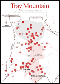
Map References: USGS 1:24,000 series: Macedonia–Tray Mountain.
Read and add comments about this page