 Helen
and the Upper Chattahoochee Helen
and the Upper Chattahoochee
Helen
and the Upper Chattahoochee Helen
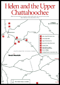
and the Upper Chattahoochee The north Georgia town of Helen [Fig. 27] developed around the Byrd-Matthews Sawmill, which was built in 1912. The town was named for the daughter of John McCombs, a prominent citizen of that era who was part owner of the mill and of the newly built railroad through the valley. The sawmill operated continuously until the late 1920s, when the virgin pines and hardwoods, once plentiful here, had been cut down and run through its blades. It was subsequently demolished.
For the next 40 years, Helen's fortunes declined. Bypassed by the major transportation routes through the mountains, it got little benefit from the steady increase in tourism that the mountain region as a whole experienced during that period, and the town's few citizens found jobs scarce. A new women's apparel plant, Orbit Manufacturing, was opened in the early 1960s and run by a man named Jim Wilkins, and a few people were hired. But the town was almost a ghost town in 1968, when the business district consisted of one rundown motel and 16 concrete block buildings, 9 of them empty. Then things began to change.
Three men were the prime movers behind born-again Helen. One of them was Jim Wilkins, the founder of Orbit Manufacturing, who owned most of the west side of the business district. Another was Pete Hodgkinson, who lived in nearby Clarkesville, worked with Wilkins in the management of Orbit, and also owned land in Helen. They added their ideas and resources to those of the third member of the triumvirate, John Kollock, an artist who lived nearby and had a passion for the architecture and landscape of the Bavarian Alps. Within a week of their first meeting, these three drew up the initial plan for putting a new face on Helen—one calculated to be alluring to the mountain tourists. Kollock drew a series of sketches depicting his vision of what the town would look like after its projected transformation, and the other two wasted no time in convincing their fellow businessmen and property owners in town to cooperate with the effort. Hodgkinson was later killed in 1976 in an accident while hot air ballooning, a sport he brought to Helen and which later developed into one of the area's major promotional attractions—the Helen-to-the-Atlantic Balloon Race.
In the years since, Helen has developed into a major north Georgia tourist attraction, drawing visitors from Atlanta and all over the Southeast. Although Orbit Manufacturing has closed, outside entrepreneurs have opened new businesses, all in keeping with the Bavarian Alpine theme, and have bought up slices of the surrounding woodlands for development as second-home sites.
Visitors to Helen can wander through the Alpine-style shops to browse for antiques, brownies, books, Indian jewelry, cigars, backpacks, and Christmas ornaments, or sit on a restaurant deck overlooking the Chattahoochee to dine on anything from pizza to knockwurst.
 Nacoochee
Valley
Nacoochee
Valley [Fig. 27(4)] Just north of the junction of GA 75 and GA 17, the Nacoochee Valley extends to the east. In the foreground is the Nacoochee Indian Mound, rising from the flat pastureland and crowned with a white latticework gazebo. A much larger, wooded mound stands in the floodplain to the east. At the time of the first European contact with this area—Hernando De Soto's 1540 expedition in search of gold—this was the center of civilization in the region, a Cherokee town called Guasili, or Guaxale. The mound, however, predates even the Cherokees; it was built by their predecessors in this valley, the Uchee Indians. The name "Nacoochee," in fact, comes from the Uchee word for this small temple mound, nagutsi.
[Fig. 27(4)] Just north of the GA 75/17 junction is the impressive Italianate Victorian house known as West End. One of the oldest surviving structures in the valley, it was built in 1870 for retired Confederate colonel John Nichols and was later occupied by Lamartine Griffin Hardman, Georgia governor from 1927 to 1931.
The first bridge south of the Chattahoochee River crosses Duke's Creek on GA 75 [Fig. 27(6)]. This is the site of the first discovery of gold in White County (see state historical marker). In the floodplain east of the bridge, there is a series of narrow ponds. These are ponds associated with mining the placer deposits (gold in stream gravel). In some river floodplains, huge dredges were floated in ponds of their own digging, digging out in front and filling in behind.
The section of the Chattahoochee River above Helen is a tight, difficult, and rapidly descending mountain river. This section can usually be run only after a rain, and water levels vary almost hourly. It should be run in the spring only by experts paddling in small parties.
The Upper Chattahoochee, from Nacoochee Valley to GA 255, is a nice float on moderate rapids. Near the end of the valley, Sautee Creek [Fig. 27(5)] enters from the left. Many paddlers put their boats into Sautee Creek on Lynch Mountain Road, an unpaved county road next to the GA 17 bridge over the creek. This is a short float across the valley to the main stream of the Chattahoochee.
As noted in North Georgia Canoeing, by Bob Sehlinger and Don Otey, from the Sautee Creek junction down to GA 255 is one of the longest undisturbed stretches of the river. The terrain is heavily forested, with large white pines and frequent rock outcroppings. Rapids are fairly frequent but are of the mild Class I and II category.
The section between GA 255 and GA 115 contains some Class III water. From GA 115 to Duncan Bridge [Fig. 27(7)] is the section most appealing to whitewater buffs. None of the rapids are particularly difficult; but combined, they provide interesting and challenging canoeing.
Other put-in and take-out points: 1) The GA 255 bridge, on the left (Habersham County side) of the river only. The property owner on the right side should not be disturbed. Use the public highway right-of-way. 2) Duncan Bridge. The distance from Jasus Creek to Helen is about 8 river miles; approximately six hours should be allowed for the run. From Helen to the GA 255 bridge is approximately 13 miles; from the GA 255 bridge to the GA 115 bridge is 4.2 miles, and from there to Duncan Bridge is about 4 miles. The Wildewood Outpost runs a parking lot at Duncan Bridge; there is a fee.
This campsite on the banks of the upper Chattahoochee provides access to the nearby Mark Trail Wilderness Area and Appalachian Trail.
 Unicoi
State Park
Unicoi
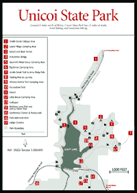
State Park [Fig. 28] Just 2 miles north of Helen, Unicoi is a 1,081-acre park with a beautiful 100-room lodge plus a wide range of other accommodations and a buffet-style restaurant. Popular activities include hiking on 12 miles of trails, trout fishing, mountain biking on a 7-mile trail, group camping and walk-in tent campsites, mountain culture programs, and a craft shop in the lodge. Special events at this site include the Fireside Arts and Crafts Show in February, the Wildflower Weekend in April, the Folk Life Festival in June, and the week-long Earthskills Workshop in the spring and in the fall.
UNICOI LAKE TRAIL. This is an easy, 2.4-mile loop trail around Unicoi Lake, across the dam, and back to the lodge.
BOTTOMS LOOP TRAIL. 2.1 miles. An easy, pleasant trail past streams, fields, low ridges, and wildflower displays.
UNICOI/HELEN TRAIL. 3 miles one-way. A pleasant walk from the lodge to Helen.
[Fig. 27] This landmark peak, located in Georgia's Piedmont region, is a monolith of granite gneiss. It and its companion, Pink Mountain, are highly visible from the Richard Russell Scenic Highway and stand as isolated peaks in the Dahlonega Gold Belt. Yonah's convenient cliffs provide mountaineering experience for U.S. Army ranger units as well as other climbers. Most of Yonah (meaning "bear" in the Cherokee language) is in the Chattahoochee National Forest.
Map References: USGS 1:100,000 series: Toccoa.
Read and add comments about this page