 The
Appalachian Trail in Virginia
The
Appalachian Trail in Virginia
The
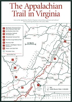
Appalachian Trail in Virginia [Fig. 46(47), Fig. 47] The Appalachian Trail is a footpath of more than 2,150 miles, stretching along the Appalachian Mountains and across great river valleys from Springer Mountain, Georgia, to Mount Katahdin, Maine. It's the longest footpath in the world, passing through 14 states.
Developing the AT took an enormous creative effort, requiring the cooperation of volunteers with federal, state, and local agencies. The trail was first proposed in an inspired magazine article by U.S. Forest Service planner Benton MacKaye of Massachusetts in 1921. His idea was to link Mount Washington in New Hampshire—the highest peak in the northern Appalachians—with Mount Mitchell in North Carolina—the highest peak in the southern Appalachians. Plans for the northern terminus extended the trail to Mount Katahdin. The southern terminus was first Lookout Mountain near Chattanooga, Tennessee, then changed to Mount Oglethorpe, Georgia, and then to its current location at Springer Mountain, Georgia.
In 1925, workers organized the Appalachian Trail Conference (ATC), a private nonprofit organization that today still oversees trail maintenance and management. The ATC chose the route; flagged it; built sections of trail, bridges, and steps where necessary; built shelters for hikers and backpackers; wrote guidebooks; and erected signs to aid hikers. In 1937, MacKaye's dream became reality with the dedication of the verdant pathway from New England across the Mason-Dixon Line to the Deep South.
In 1968, Congress passed the National Trails System Act, making the Appalachian Trail (AT) on the East Coast and the Canada-to-Mexico Pacific Crest Trail on the West Coast the first National Scenic Trails.
Although 14 states claim parts of the white-blazed AT, no state comes anywhere close to the 545 miles—more than a fourth of the total milage—that pass through Virginia. As it runs northeast/southwest up the Appalachians, the trail crosses back and forth across the Great Valley of Virginia to take in parts of all three mountainous portions of Virginia's five physiographic provinces—Plateau, Valley and Ridge, and Blue Ridge. It varies in altitude from just 660 feet above sea level at the James River crossing to well over 1 mile high atop Mount Rogers (5,729 feet).
Those who hike the complete AT through the state will travel through many sites covered in this book. Circuit hikes can be arranged to suit the individual by combining sections of the AT with connecting trails in various state parks, national forest districts, Shenandoah National Park, and along the Blue Ridge Parkway. Otherwise, hiking a stretch of the trail requires doubling back or leaving a second car at the finish.
The AT comes into Virginia from North Carolina at Damascus, in southeastern Washington County. A rugged but scenic 54.6 miles of the AT wind along the Iron Mountains of Mount Rogers National Recreation Area in the Blue Ridge Highlands. Then the footpath heads northward in southwest Virginia, zigzagging its way across the Valley and Ridge province. The trail runs the ridge above the amazing bowl of Burkes Garden on the Bland/Tazewell county line. It angles northeast to cross the New River and trace the edge of the Plateau province through Peters Mountain Wilderness along the West Virginia border for a few miles. Like a meandering river, it then wanders lazily south, east, and northeast across the Great Valley again to rejoin the Blue Ridge mountains north of Roanoke.
From mile 103 on the Blue Ridge Parkway, it plays tag with the Parkway and then the Skyline Drive along the mountain crests. North of Skyline Drive, it leads through acre upon acre of trillium carpeting the slopes of Thompson Wildlife Management Area as it heads for the confluence of the Shenandoah and Potomac rivers at Harpers Ferry, West Virginia, where the parent ATC organization is located. A crossing of the Shenandoah on the West Virginia line leaves hikers heading north with a last reminder of Virginia's gentle beauty.
Those who have become familiar with those 545 miles of AT have seen hemlock-lined ravines where rhododendrons bloom and jack-in-the-pulpits hide along stream edges. They've delighted in damp spring mornings after a rain when the fields are fragrant with honeysuckle. They've seen soaring cliffs of granite and greenstone that intrigue geologists and watched the turning of the heavens in the night sky over their campsites. The pool of a waterfall has cooled weary feet, the stump of an old chestnut has supported an achy back, and a sun-warmed handful of blackberries has served as breakfast.
If they're lucky, a black bear or two has crossed their path, an eagle has soared the ridgeline beside them, and a whip-poor-will has sung them a wilderness lullaby. They've also learned something of their own nature as they cope with loneliness, overcrowded shelters, heat rash, wet clothing, a leaking tent, a bee sting, blisters, and boredom. The trail is rarely easy, but the rewards are great. Like a river valley, the green corridor of the AT is largely hidden and unknown to all but the relatively few who follow it.
Many hikers who spend a lot of time on the trail become so appreciative of the never-ending job of volunteers from local ATC groups, they end up joining a chapter. These volunteers build bridges and shelters, identify rare species along the trail that need protection, remove debris after storms, and work to protect the rights of bordering landowners while keeping the trail open for everyone to enjoy.
The white, 2-by-6-inch, rectangular trail markers are painted on trees and rocks. A double blaze—one above the other—warns of turns, junctions, or other places where the hiker should be alert. Blue blazes mark AT side trails. Usually, these lead to shelters, a water supply, or viewpoints.
For more information: For guidebooks, maps, and other publications or to find out the closest affiliated AT club, contact the Appalachian Trail Conference, PO Box 807, Washington and Jackson Streets, Harpers Ferry, WV 25425-0807. Phone (304) 535-6331.
Read and add comments about this page