| |
Wildlife Viewing Guide |
 Northeast
Georgia Mountains
Northeast
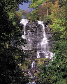
Georgia MountainsThis region is characterized by the metamorphic geology of the Southern Appalachians, an ancient mountain range originally formed by pressure, heat, and water that has been eroding for the past 400 million years. The resulting rounded mountain range has thus formed rich forest soils which support the most diverse plant life in the State, and in turn a highly diversewildlife community. The wildflowers of the north-facing coves, such as Sosebee Cove, are world-famous. So, too, are the pure whitewater streams, as they leap over the falls of Tallulah, Amicalola, and Duke's Creek. The heaviest rainfall in Georgia occurs here, contributing to the lush green mountains and to the illusion of "smoke" with low-hanging cloudsresting in the valleys many days during the year. The State's highest elevation (4784 feet) occurs here at Brasstown Bald. The 2000-mile-long Appalachian Trail begins here at SpringerMountain, creating a mythical, albeit man-made, connection to Mount Katahdin, the highest elevation in the State of Maine.
Read and add comments about this page