 The
Cumberland Plateau The
Cumberland Plateau
The
Cumberland Plateau The
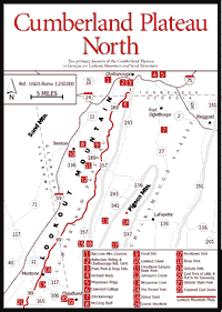
Cumberland Plateau The Cumberland Plateau begins near Birmingham, Alabama, and crosses the extreme northwest corner of Georgia before entering Tennessee just to the west of Chattanooga. Northwest of Knoxville, the plateau becomes highly dissected due to erosion, and the region—although geologically still a plateau—is called the Cumberland Mountains.
The two principal features of the Cumberland Plateau in Georgia are Sand Mountain and Lookout Mountain, which are separated by 2-mile-wide Lookout Valley, in which the towns of Trenton and Rising Fawn are located.
From a physiographic standpoint, the flat-topped mountains of the Cumberland Plateau are quite different from the narrow Armuchee Ridges beyond the Chickamauga Valley to the east. Geologically, the Cumberland Plateau is transitional between the flat-lying sedimentary beds of central Tennessee and the ridges and valleys to the east in Georgia, which show more intensive folding and faulting.
The flat top of the Cumberland Plateau is sandstone which, while harder than limestone or shale, has nevertheless been carved and sculpted for millions of years by wind and water. Because of a tendency to fracture into squarish blocks, the sandstone has weathered into fantastic boulder formations in places like Rocktown and the Zahnd Tract, commercially called "rock cities." In addition, thick layers of soft, water-soluble limestone undergird the Cumberland Plateau. Because the top is actually slightly concave, surface water accumulates and seeps downward through cracks and crevices, where it dissolves the limestone and creates miles of underground passages or caves, issuing forth at numerous springs around the base of the mountain.
The great gulfs, or canyons, eroded in the sides of the Cumberland Plateau are spectacular in a geologic, biotic, and scenic sense. Two on Lookout Mountain are notable—a wide canyon known as Johnson's Crook, and a narrow one called Sitton's Gulch and renamed Cloudland Canyon.
Pigeon Mountain, a thumblike protrusion from Lookout Mountain, deserves special mention. It is a geological, botanical, and zoological treasure house. Happily, most of it was purchased by Heritage Trust funds under the farsighted Carter administration.
 Lookout
Mountain
Lookout
Mountain Lookout Mountain is the southernmost extension of the Cumberland Plateau, which is parallel to but inland from the Blue Ridge Mountains. Long and relatively flat on top, it extends for 84 miles in a diagonal that cuts across Alabama, Georgia, and Tennessee. There are 3 miles of Lookout Mountain in Tennessee, 31 in Georgia, and 50 in Alabama. The mountain is in one of the world's richest cave regions.
[Fig. 5] The designation is sometimes confusing because the "parkway" includes several roads, not just one. Nevertheless, this multihighway driving route provides visitors to the region with an overview of the dramatic piece of geography between Gadsden, Alabama, and Chattanooga, Tennessee, that is Lookout Mountain. The route begins in Gadsden as AL 176 and runs in a northeasterly direction to Chattanooga. The mountain can be traversed not only in a north-south direction, but east-west as well. Visitors who explore county roads across the width of the mountain will have a better understanding of how this long, flat mountain of the Cumberland Plateau differs from the peaks and ridges of the Blue Ridge Mountains.
[(Fig. 5(2)] Reflection Riding is a 300-acre nature preserve along Lookout Creek at the base of Lookout Mountain. It adjoins 2,000-acre Point Park and Lookout Mountain Battlefield National Military Park. The area is maintained in the style of an English natural landscape and is crisscrossed by winding paths and graveled roads. It gains its name from Reflection Pond, a landmark on the property, and the English word "riding," which means an inviting pleasure path. The Great Indian War Path and the St. Augustine and Cisca Trail crossed Reflection Riding. Hernando De Soto's troops followed the Great Indian War Path over this area looking for gold. A gristmill operated by two Cherokees was on this site. Only the millstones remain today. In 1863 Union forces under General Hooker crossed Lookout Creek to engage the Confederate Army in the Battle of Lookout Mountain. Markers describing the battle are placed at many points along the drive.
Deep gorges, rock fields, and moss-covered boulders provide interesting toporaphy as well as shelter for many species of birds and other wildlife. The edges of Lookout Creek furnish habitat for bog plants, frogs, and other small water creatures. Wildflowers and grasses cover the open meadows. Native rhododendron and azaleas have been planted on the mountain slope. The forest is predominantly oak with scattered groves of pine. The 12 miles of trails are well marked and make for relatively easy walking. All of the trails are interconnected, so a hike can be as long or short as desired and flexible in destination. From the park border trail and the driving loop, there are connections to the National Park Service trails. Maps are available at the nature center. The wetland walkway, accessible to handicapped visitors with wheelchairs, leads from the road in front of the nature center through the animal habitats to a lovely overlook beside the creek.
Along the 3-mile driving loop, most of the trees and shrubs are identified, as are points of historical interest. During the blooming seasons of spring, summer, and fall, a variety of wildflowers can be seen. Plant identification guides corresponding to the numbered plant labels are available at the nature center. There are frequent stopping places along the way. Surrounded by ferns, the secluded gazebo overlooking Siren Pool has benches and shade where visitors can sit quietly and relax. The screened pavilion at the fragrance garden has benches and outside picnic tables.
Located at the gateway to Reflection Riding, the nature center features passive solar-designed buildings containing a wildlife diorama, exhibits, a library, resource collections, and a gift shop. An auditorium and solar greenhouse are next to the wildlife rehabilitation laboratory, where visitors can visit injured and orphaned wild animals, including hawks and owls. On weekends, programs including workshops, films, classes and interpretive walks are offered. Special programs are available upon request. Hand-fed Canada geese, mallards, and wood ducks are year-round residents of Reflection Pond. Visitors are allowed to feed them. The nature center also offers a summer day camp and an annual wildflower walk in mid-April.
Here in the northwest corner of Georgia, the northeast corner of Alabama, and the southern part of Tennessee, cavers have discovered a region linked by the Cumberland Plateau and characterized by a vast network of caves cut through limestone rock. To cavers this region is not Tennessee, Alabama, and Georgia, but "TAG." They come from all over the world to explore its labyrinthine underground passages. Tennessee alone has more than 5,500 caves—more than any other state. Ellison's Cave on Georgia's Pigeon Mountain is the deepest cave east of the Mississippi River.
A few caves in the region are commercial, open to the public for a fee. These include famous caves such as Ruby Falls in Lookout Mountain and lesser-known sites such as Sequoyah Caverns near Valley Head, Alabama. Business volume varies greatly at different caves. Raccoon Mountain Caverns estimates some 10,000 visitors a year, while perhaps 350,000 annually see Ruby Falls.
Fig [5(1)] The absence of props such as dramatic music and sophisticated lighting allows the visitor to experience the natural environment of the cave. Visitors may receive a personal tour by a knowledgeable caver. Wild tours—explorations of parts of the cave not normally seen by those taking commercial tours—last from two hours to overnight and are available by appointment only. Hard hats, lights, and other necessary caving equipment are furnished.
[Fig. 5(3)] This is the most heavily promoted and commercially successful cave in the Southeast. Visitors ride an elevator 260 feet down into the cavern. They then walk .4 mile one-way, past a variety of rock formations to Ruby Falls, with its 145-foot cascade lighted from below with multicolored spots and accompanied by the theme from the movie 2001. Tour guides are cheerful and enthusiastic college students.
 Covenant
College
Covenant
College [Fig. 5(6)] Called the "Castle in the Clouds," a name first applied to the luxury hotel and gambling casino that occupied this site in the late 1920s, Covenant is a four-year, Presbyterian-affiliated college. A visit to the campus affords the visitor with the only unobstructed, 360-degree panorama of the country beyond the mountain.
[Fig. 5(8)] (Lookout Mountain Flight Park and Training Center). Sixty miles of ridgeline and the unique thermal-producing qualities of the valley floor make this the premier hang gliding site on the East Coast. Pilots from all over the world sail high above the Lookout Mountain Ridge and fly for hours up and down the valley. There is usually activity every day, and spectators get a close-up, breathtaking view of winged participants jumping off the sheer cliffside. The local flight-distance record is 154 miles. The pilot launched here and landed 70 miles east of Atlanta at Swords, Georgia. National and regional competitions are held here on a regular basis.
[(Fig. 5(9)] Pennsylvanian plant fossils. Fossils to be found include tree fern–like plants called Sigillaria; small ferns such as Pecopteris, Alethopteris, Neuropteris, Archeopteris; and others.
 Lookout
Creek
Lookout
Creek [Fig. 5(10)] Lookout Creek runs through Lookout Valley, along the base of Lookout Mountain. It begins just across the state line near the little town of Valley Head, Alabama. It then flows northeastward, slicing across the extreme northwestern corner of Georgia, then into Tennessee, where it empties into the mighty Tennessee River at the base of Lookout Mountain in Chattanooga. It weaves its way through Georgia for 30 miles, in and out of wilderness areas and pastureland, offering the canoeist briskly flowing flat waters and a moderate number of Class I shoals. Scenery varies dramatically during the 9-mile run between the put-in and take-out points described here. At one moment canoeists pass through heavy forests, the next through open pastureland that offers impressive views of Lookout Mountain, a constant companion to the east. Although the headwaters of Lookout Creek are scarcely a mile from the headwaters of Little River, these two neighboring rivers flow in opposite directions. The former flows north, placidly winding through Lookout Valley. The latter flows south, roaring violently down the spine of the mountain. The explanation is that although born in the same neighborhood, the streams belong to different watersheds. Lookout Creek belongs to the Tennessee Valley watershed; the Little River, to the Coosa Valley watershed. This fact also explains why Lookout Creek can maintain its water level, since it is filled by water running off the western slopes of the entire Lookout Mountain Plateau, while its rocky-bottomed neighbor up on the mountain, fed by a smaller watershed, can quickly run dry.
 Cloudland
Canyon State Park
Cloudland
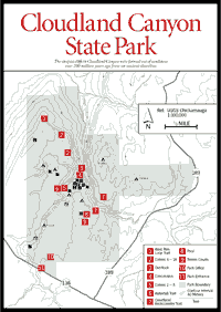
Canyon State Park [Fig. 5(11), Fig. 7] Located on the western edge of Lookout Mountain, Cloudland Canyon is one of the largest and most scenic state parks in Georgia. The park provides visitors with beautiful vistas of the rugged geology of this area, and it is an excellent outdoor setting for the camper or hiker wanting to experience the beauty of the natural world. Cloudland was established in 1939 when the state of Georgia began the acquisition of land from several private landowners. Today it encompasses some 2,350 acres of beautiful mountain land. Until 1939, when construction of a Georgia highway through this area was finally completed, the only access was through Alabama or Tennessee. The park is perhaps one of the best places to view and understand the geology of northwest Georgia. An excellent guidebook, the Geologic Guide to Cloudland Canyon State Park, by Martha Griffin and Robert Atkins, is available at the park office. It discusses the fascinating geology of this area at ten stations around the rim trails and along the trails to waterfalls on Daniel's Creek.
The park straddles a deep gorge cut into the west side of Lookout Mountain by Sitton Gulch Creek. The elevation here drops from 1,800 to 800 feet above sea level at the bottom of the gorge. The rimrock and steeper cliffs are resistant sandstone formed over 200 million years ago from beach and dune sands of an ancient shoreline. Shale layers below the sandstone are marked by a growth of pines. At the canyon bottom is a slope of rock fragments called "talus" that is now heavily forested. The valley floor and gentle slopes seen in the distance are formed of fossil-bearing limestone. Special events at this site include Crafts in the Clouds during the third weekend in May, a wildflower program in May, and a backpacking trip in October.
 Hiking
Trails of Cloudland Canyon State Park
Hiking
Trails of Cloudland Canyon State Park The canyon's rugged beauty is a joy year-round, each season offering special sights and sounds for visitors. A hike down Cloudland's trails to the canyon floor is a walk through millions of geologic years. Trails are well marked and easy to follow. The park provides good interpretive information about the history and geology of the area. Maps and directions to the trailheads are available in the park office.
WEST RIM LOOP TRAIL. [Fig. 7(l)] 4.9 miles. Part of the trail follows the canyon rim close to its edge. An overlook provides views into the three park gorges.
WATERFALL TRAIL. [Fig. 7(6)] .3 mile. Walk to two waterfalls on Daniel Creek.
CLOUDLAND BACKCOUNTRY TRAILS. [Fig. 7(7)] 5.4-mile loop. Backpacking and camping are permitted on this trail. Stop by the park office to obtain a permit and pay the $3-per-person fee.
[Fig. 5(12)] Johnson's Crook is a deep indentation or cove on the west side of Lookout Mountain, located entirely in Dade County, Georgia. The valley of the crook is about 1,100 feet above sea level, and the brow around it ranges from 1,900 to 2,100 feet. The village of Rising Fawn and impressive Fox Mountain are immediately to the west of the crook.
In September 1863, shortly before the Battle of Chickamauga, an epic event occurred when 40,000 Union troops marched from Rising Fawn east into the crook and up, over, and down Lookout Mountain, building a road as they advanced and carrying with them all of the equipment of war.
 Zahnd
Tract
Zahnd
Tract [Fig. 5(15), Fig. 6(15)] This is an area of large, unusual rock formations characteristic of this region. Also present is a mixture of mesic (liking moist conditions), xeric (liking dry conditions), and Coastal Plain plants. Most visible from the road is the mountain laurel, which is especially abundant and blooms in May. The plot is owned by the state of Georgia. The rocks are about 200 feet off the road, east of GA 157.
[Fig. 5(6), Fig. 6(16)] On GA 157, look for a metal highway rail about 11.9 miles north of GA 48 (or 10 miles south of the intersection of GA 136 and GA 157 south) which overlooks McLemore Cove [Fig. 5(13)], a breached, eroded, anticlinal valley between Pigeon and Lookout mountains.
[Fig. 5(22), Fig. 6(22)] Just before the brow of the mountain, a thinly bedded seam of coal is visible under massive sandstone and over shale. During the millions of years of the Carboniferous period, huge tree ferns and giant horsetails which were 1 to 2 feet in diameter and 60 or more feet high lived in the great swamps and river deltas that circled the northern hemisphere. As these plants died and fell to the earth, the swamp water prevented them from losing their carbon by oxidation. After eons of peat formation, these carbonized remains were compressed into layers of coal, which has powered mankind ever since. To split a piece of coal and find the imprint of the leaves of these ancient forests is one of the most significant experiences in the study of natural history. Birmingham, Alabama, became a great metallurgical center because of its combination of coal and iron deposits somewhat similar to those around Lookout Mountain.
 Pigeon
Mountain
Pigeon
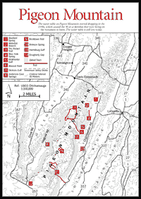
Mountain Pigeon Mountain [Fig. 4, Fig. 5, & Fig. 8] and Lookout Mountain form a V, like the thumb and index finger of a person's left hand held palm down, with Lookout being the index finger and Pigeon being the thumb. Nestled in the V shape is the Chickamauga Valley's lovely McLemore Cove, a National Historic District [Fig. 5(13)]. The northern tip of Pigeon Mountain lies about 3 miles west of LaFayette and stretches southwest for 10 miles, where it joins with Lookout Mountain. The mountain was named for the passenger pigeon, now extinct, which in the 1800s roosted there by the thousands. In the 1920s and 1930s some 30 families lived on Pigeon Mountain, working small farms and perhaps making moonshine liquor. Their names have stayed behind as part of the landscape, as in Rape Gap, Ellison's Cave, and Pettijohn's Cave. The 1930s saw a lowering of the water table on the mountain, causing all the wells to dry up and the families to abandon their homes. The water table has yet to return to its former level.
This is an area with many natural features of exceptional value for wildlife, recreation, and historical, archeological, and educational purposes. For years it has been studied by scientists, who are still finding new and exciting plants, animals, and natural environments. Some 21 rare plants and several rare salamanders are found here. The area was leased by the Georgia Department of Natural Resources in 1969. Since that time, the state has purchased more than 13,000 acres of the mountain. The land is managed as the Crockford–Pigeon Mountain Wildlife Management Area, primarily for wildlife and the protection and enhancement of the mountain's many natural features.
Like Lookout Mountain, Pigeon Mountain is laced with caves that wind all through the limestone rock. There are many cave entrances on the mountain, and it is an important location for cavers throughout the Southeast. Ellison's Cave contains two exceptionally deep pits—Fantastic Pit at 586 feet and Incredible Dome Pit at 440 feet. About 13 miles of Ellison's Cave have been explored and mapped. In fact, it is likely that Pigeon Mountain is a vast system of underground caverns and stream channels. Pettijohn's Cave was first described in 1837. Approximately 6 miles of passageways in this cave have been mapped, and new passages are still being discovered. This cave has seen much more use than Ellison's and has sustained more damage to its mineral formations.
It should be emphasized also that the underground can be an extremely dangerous area to explore for individuals unfamiliar with the skills required in caving. Caves should be explored only in the company of well-equipped, experienced cavers.
WATERFALL BRANCH. [Fig. 8(2)] A small stream containing a scenic waterfall. Several rare plants have been recorded on the east- and northeast-facing slopes in the vicinity of this stream, including the hairy mock-orange, hedge nettle, Alabama snow-wreath, wild hyacinth, nodding spurge, celandine poppy, and state-protected twinleaf.
BLUE HOLE. [Fig. 8(4)] This is a large spring located at the base of the eastern slope of Pigeon Mountain. The unusual bluish color of its waters, its constant 56-degree Fahrenheit temperature, and the fact that it represents a hydrological discharge of the extensive Ellison's Cave system make this a significant feature. It is accessible by vehicle. No camping is allowed within 100 feet of the spring.
MCWHORTER GULF, DICKSON GULF, AND HARRISBURG GULF. [Fig. 8(5, 7, 11)] These gulfs contain the important and rare Pigeon Mountain salamander, a species known from only four sites, all located along the eastern slope of Pigeon Mountain. The green salamander has also been collected from this area. Collecting is prohibited except by specific permit.
SAGPONDS. These are water-filled depressions formed when underlying limestone strata are dissolved by groundwater and "slumping" occurs. Many of these sagponds serve as important groundwater recharge areas, slowly adding water to underground reserves. Several natural sagponds are found atop Pigeon Mountain. Some of these have been valuable to scientists who drilled through deep layers of peat, which accumulates in sagponds, and found ancient pollen samples which enabled documentation of the vegetation that covered the area during the Ice Age.
ROCKTOWN TRAIL. [Fig. 6(17), Fig. 8(9)] 1 mile one-way. Exploration of the massive boulders within the 150 acres of Rocktown can easily consume the better part of a day. The biggest mistake visitors can make is not to allow enough time to inspect this unusual site. Some of the boulders are as large as three-story office buildings; a narrow pedestal supporting a caprock resembles a 25-foot-tall champagne glass; and deep inside a narrow, dark crevice it is cool enough for hikers to see their breath even though the outside temperature may be close to 80 degrees Fahrenheit.
The reddish rocks of this ancient river delta that hikers see along the trail or imbedded in the sandstone formations of Rocktown are iron ore deposits. At one time there were 10 iron mines on the mountain. These deposits add a special visual interest to the Rocktown environment, because the softer sandstone erodes around them. Rocktown is easy to reach and would be a suitable hike for those of almost any age or physical condition. Children could, however, accidentally stray from the trail. The trail is marked with pink blazes.
THE POCKET TRAIL. [Fig. 5(14), Fig. 8(3)] This is a loop trail about 9.5 miles long. This steep trail climbs Pigeon Mountain and follows the ridgeline for 2.3 miles. The view to the northwest looks down on McLemore Cove, a valley of farmland between Pigeon and Lookout mountains, and across to Lookout Mountain itself. Here the hiker has an excellent opportunity to observe and carefully climb on the unusual rock formations typical of this portion of the Cumberland Plateau. The fractured sandstone has been weathered and eroded over thousands of years into spires and teetering boulders that are most dramatic, particularly when perched—as many of them are—on the edge of the mountain.
Several rare or uncommon plant species have been recorded here, making it one of the most remarkable botanical areas in northwest Georgia. There are at least 11 significant species, found almost nowhere else in Georgia, present in the small patch of mesic hardwood forest below the wet-weather falls. These include celandine poppy, Ohio buckeye, bent trillium, nodding spurge, lanceleaf trillium, wild hyacinth, log fern, harbinger of spring, Virginia bluebells, hairy mock-orange, and blue ash. When the plants are in bloom, the forest below the waterfall near the start of the trail is truly remarkable, with some species occurring in quite thick beds. The rocky slopes above The Pocket contain an unusual open forest community dominated by red cedar and chinquapin oak. The forest also includes the smoketree, a rarity in Georgia. Hedge nettle, another new occurrence for the state, was first observed on slopes above the open meadow.
[Fig. 5(13)] Before leaving this area, the reader may wish to visit nearby McLemore Cove, located in the Chickamauga Valley. (See McLemore Cove.)
 Little
River, Alabama
Little
River, Alabama [Fig. 5(18), Fig. 6(18)] Here visitors can get a representative sample of what the views are like along the entire length of Lookout Mountain. Picnic tables, good sunset views.
[Fig. 5(19), Fig. 6(19)] In addition to a beautiful 100-foot waterfall, there is a dam creating a lovely mountain lake which provides swimming, fishing, and boating.
[Fig. 5(21), Fig. 6(21)] This fine Alabama state park has approximately 8 miles of easy-to-follow, well-marked hiking trails within the main area of the park. Rustic foot bridges span many of the streams; unusual rock formations and rare forms of plant life are found along these trails.
 DeSoto
Scout Trail
DeSoto
Scout Trail [Fig. 5(21), Fig. 6(21)] This is a 16-mile trail that begins at Comer Scout Camp and follows the West Fork of Little River to a spot north of AL 35. The trail has been poorly maintained in recent years. Inquire at the DeSoto State Park Country Store for trail conditions and detailed directions to the trailhead.
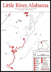
[Fig. 6(24), Fig. 9(7)] Little River Canyon on long, flat Lookout Mountain is one of the deepest gorges in the eastern United States. With an average depth of 400 feet, it is 700 feet at its deepest point and .75 mile across. Little River flows right down the middle of the canyon and, therefore, down the spine of Lookout Mountain, making it the only river in North America to flow its entire length along a mountaintop.
Geologists have devised two theories to explain the canyon's formation, neither of which has been proved or disproved. One is that the river may have once flowed underground until its roof overhead caved in and exposed it. Or perhaps an upheaval within the earth opened up a crevice which was enlarged over time by the erosive action of the river formed within it.
GRACE HIGH FALLS. [Fig. 6(25), Fig. 9(5)] The highest waterfall in Alabama, it is located on the south side of Bear Creek Canyon but can be seen only from the north side of the canyon.
LITTLE RIVER CANYON PARKWAY—RIM DRIVE. [Fig. 9(7)] This is a spectacular 22-mile drive along the western rim of Little River Canyon. The road passes a dozen lookout points and is a rewarding route to experience one of the most outstanding natural landscapes in the Southeast.
LITTLE RIVER. [Fig. 6(20)] Little River is classified as an Alabama Wild and Scenic River. It would have qualified as a National Wild and Scenic River had it not been for the now-abandoned chairlift near the intersection of AL 176 and Rim Road. It is the only river in North America that flows its entire length on top of a mountain. Etched deep in the spine of the long Alabama portion of Lookout Mountain, it flows through one of the deepest canyons east of the Rockies.
Born in the uplands around Mentone, Little River grows until it reaches the dramatic 100-foot DeSoto Falls at DeSoto State Park. It is a pretty Class II run until it is joined by its east fork just above the AL 35 Bridge. Just below the bridge it takes a lethal, 60-foot plunge downward and the Little River Canyon is dramatically born.
When the water level is right, the river is a fast and heavy whitewater run of repeated Class II, III, and IV rapids. Only experienced canoeists should attempt it. Even then, it should be run only after careful preparation and on-the-spot information checks with the DeSoto State Park information office. There are no water gauges in Little River, and levels can change from unrunably bumpy in low water to suicidally heavy in high water. This river requires a support team of at least three canoes equipped with heavy throw ropes, life vests, and helmets. The canyon section of the river runs 16 miles from the AL 35 Bridge to Canyon Mouth Park, but only half of this is suitable for canoeing.
The run from Eberhart's Point to Canyon Mouth Park is approximately 8 miles, but the distance is deceptive. Canoeists will need all the daylight hours available for unpredictable portages and unavoidable delays. Once in the canyon, one has no way out but downriver. In moderate water some of the rapids must be portaged. Do not try to run the section of the river from AL 35 to Eberhart's Point. According to park officials, most who try this end up having to rope themselves and their damaged canoes up the 500-foot cliffs to get out. Consider coordinating a canoe trip with an accompanying hiking party. This will provide additional support for the put-in portage and other necessary portages around unrunable rapids.
EAST FORK OF THE LITTLE RIVER. [Fig. 5(20), Fig. 6(20)] The East Fork of Little River provides the average canoeist with a safe yet exciting way to experience this canyon area without having to face the dangers and difficulties of Little River Canyon farther downstream. Located north of the actual canyon area, the East Fork is a canoeable Class I–III tributary for paddlers of beginner and intermediate skills. It begins in the southwest corner of Georgia's Walker County and flows into Alabama for a distance of 16 miles before it joins with the West Fork to form Little River. The information here covers the last 6 miles of the East Fork (from Lake Lahusage to the confluence with the West Fork) and the first 5 miles of the Little River (down to the AL 35 Bridge). It is just beyond this bridge that the Little River takes its dramatic plunge into the canyon. The total canoeing distance for this run is 11.2 miles, a distance that can be covered in one full day of paddling.
A rushing waterfall on Black Creek is the centerpiece of Noccalula Falls Park and Campground, located at the southwestern end of the Lookout Mountain Parkway. A re-created pioneer community depicts life of early settlers in the Appalachian foothills. Some of the buildings were moved from their original sites to be preserved here. Among these are a house built in 1877 and a large cotton warehouse built in 1888. From March until September, a train circles the edge of the park, which includes a botanical garden. A stairway leads to the gorge below the falls and the Gorge Trail. Interesting rock formations are found in the center of the park. Special events include Art on the Rocks the first Sunday in May and the Fall Fest the first Sunday in October.
Read and add comments about this page