 The
Armuchee Ridges The
Armuchee Ridges
The
Armuchee Ridges The
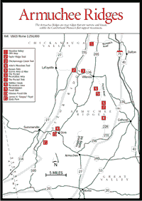
Armuchee Ridges Unlike the Cumberland Plateau's broad, flat-topped mountains complete with streams, the Armuchee Ridges are true ridges, relatively narrow and linear. The principal ridges are Taylor Ridge, John's Ridge, Horn Mountain, and Rocky Face. Roadside ditches along Taylor Ridge are filled with multimillion-year-old fossils from former sea floors. There are also "pockets" or coves, outcrops of iron ore, and attractive waterfalls to provide visitors with pleasant travel destinations.
Instead of both sides of these ridges being similar, as in the Cumberland Plateau, here opposite sides are different. For example, on Taylor Ridge the western summit face is sandstone, while the east-face cliffs are hard chert, a noncrystalline quartz. Rocky Face is similar, except that siltstone instead of limestone underlies its western flanks. These differences lead to changes in both topography and plant communities. Interstate 75 crosses Rocky Face in a deep notch just west of Dalton and continues, crossing Taylor Ridge at the famous Ringgold Cut, where the subsurface rocks are highly visible and fossils are found in the wall of the highway cut adjacent to the southbound lane.
 Taylor
Ridge
Taylor
Ridge [Fig. 10] Taylor Ridge extends as one geological unit from the village of Holland on GA 100 in Chattooga County northwestward beyond the Tennessee line. A remnant of an ancient larger ridge which once reached all the way to Lookout Mountain, it eroded over a period of some 200 million years. In the valley between Taylor Ridge and Lookout Mountain are located the towns of Summerville, LaFayette, and Ringgold. The ridge is broken by a gap at Ringgold, the Ringgold Cut, where its name is changed to Whiteoak Mountain, although it is the same structure geologically. GA 100 passes the southwest tip of the ridge. It is crossed by US 27 between Gore and Summerville, by GA 136 between Villanow and LaFayette, by I-75 at Ringgold, and by several U.S. Forest Service roads. Because of federal ownership, both John's and Horn mountains are in a wildlife management area. Gate closure is seasonal; some gates are open only for hunting.
Geological time periods which can be observed in road cuts are Silurian (the age of fishes) and Mississippian (the carboniferous "coal age" and the age of amphibians).
TAYLOR RIDGE TRAIL. [Fig. 10(1)] 2.4 miles. The trail, for foot traffic only, runs along the ridge to FS 635-A.
CHICKAMAUGA CREEK TRAIL. [Fig. 10(3)] 6.2 miles. A loop trail which begins and ends at the end of Ponder Creek Road. Foot travel only.
[Fig. 10(1)] This 2,600-acre, off-road-vehicle area has a network of trails for motorbikes and all-terrain vehicles. Timbering is conducted in this area, so visitors are asked to stay on the trails.
[Fig. 10(5)] This scenic area was set aside because of the unique rock bluffs and high elevation swampy areas formed from springs. Keown Falls, named for land surveyor Gordon Keown, are twin falls located along two spring-fed streams within the 218-acre scenic area. The larger one free-falls 60 feet and the smaller about 40 feet. During summer the streams may become dry. A sign posted at the trailhead informs visitors whether the falls are flowing. The area is scenic even when the falls are dry. The 1.8-mile Keown Falls Loop Trail begins and ends at the picnic area parking lot. It is unmarked but easily followed. The northern part of the loop provides views of moisture-loving cove hardwood tree species, and the southern portion gives views of tree species indicative of dry ridges. This trail may be used to access the 3.5-mile John's Mountain Loop Trail, which is marked with white blazes. An overlook at the top of John's Mountain offers a scenic vista of Taylor Ridge, Lookout Mountain, and the surrounding valley. Keown Falls Recreation Area, located adjacent to the scenic area, offers an abundant variety of colorful wildflowers and shrubs. Mountain laurel blooms throughout the late spring and early summer months; both the pink and white varieties bloom in June. Azaleas and dogwood add to the springtime color. The mixture of hickory, sourwood, oak, beech, and yellow poplar presents a brilliant spectrum for autumn leaf watchers. The picnic area located in a forest at the foot of John's Mountain has a flowing creek where children can wade and tired hikers can cool their feet.
[Fig. 10(4)] 3.5 miles. This loop trail begins and ends at the John's Mountain Overlook located at the end of FS 208. The trail connects with the Keown Falls Loop Trail above the falls.
[Fig. 10(6)] Not to be confused with The Pocket on Pigeon Mountain, this pocket got its name because it lies in a low pocket created by the steep ridges of Horn Mountain, which surrounds it on three sides. From 1938 through 1942, it was the site of a Civilian Conservation Corps camp. The foundations of the old structure are still visible. A large, clear, ice-cold spring bubbles up in the middle of the picnic area and flows through the recreation area as a refreshing creek for wading.
THE POCKET TRAIL. [Fig. 10(7)] A well-maintained and clearly marked hiking trail makes an easy 2.5-mile loop from the picnic area along low-lying streambeds and back to the campgrounds. When spring arrives, azaleas, dogwood, sourwood, and mountain laurel enliven the area with color. In the fall it is brilliant with the leaves of hickory, maple, oak, beech, and yellow poplar. The soil's subsurface in this area, made up of white limestone, erodes more easily than the harder rocks which make up the higher elevations in northwest Georgia. This erosion has resulted in the area's unusual topography.
[Fig. 10(8)] The recreation area is located on a creek which appears and runs clear and cool for a day or so, then disappears. The area is a prime example of an oak-hickory forest, with a few beech trees in low-lying areas. There is a wide variety of flowering shrubs and plants. Dogwood, sourwood, hickory, maple, yellow poplar, and red oak abound. The varied forest conditions offer excellent opportunities for the birder. There are no hiking trails but many dirt roads to walk.
This region of Georgia contains numerous fossil deposits. Many are exposed in road cuts which are accessible to the public.
MISSISSIPPIAN SITE. [Fig. 10(9)] From Rome take US 27 north 18.8 miles to the Gore intersection. Go .3 mile from Gore, turn right (north) onto a Forest Service road, and park almost immediately by a gate. Walk up an old woods road to the left. There are many crinoid stems, some brachiopods, some bryozoa, and rare small geodes. At this site the best picking is after a hard rainfall, which tends to expose the fossils.
SILURIAN SITE. [Fig. 10(10)] From Rome take US 27 north 18.8 miles to the Gore intersection. Go an additional 1.5 miles; turn left at the top of Taylor Ridge on a Forest Service road; go .2 mile. In the road bank on the right, find chunks of iron ore containing Silurian cephalopods such as Homotoma. Usually one must break open the ore to find the fossils. They are very small—5 to 15 millimeters long and 2 to 3 millimeters in diameter.
[Fig 10(11)] The park covers 545 acres at the base of Taylor Ridge. It was named for a Georgia state representative who served in the legislature from 1953 until his death in 1974. Two fishing lakes have wooden porch swings along their shorelines where visitors can sit and relax. Trails circle each lake. Rental boats are available and private boats are welcome. Only rowing, paddling, or trolling motors are permitted. The lakes are stocked with channel catfish, bream, and bass and are open for fishing year-round. The park has a program of wildflower planting and an ongoing program for restoring the bluebird population.
Read and add comments about this page