 Fort
Mountain State Park Fort
Mountain State Park
Fort
Mountain State Park Fort
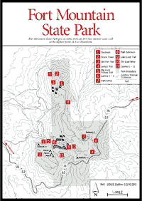
Mountain State Park Fort Mountain State Park [Fig. 17] is located on Fort Mountain, just southwest of the Cohutta Wilderness. The park derives its name from an ancient stone wall, measuring some 855 feet in length, which stands on the highest point of the mountain. Remains of circular depressions made of various-sized stones and measuring about 10 feet across occur in the wall at about 30-foot intervals. The wall ranges in height from 2 to 6 feet, although it was probably considerably higher in the past.
Archeologists and historians have been unable to solve the puzzle of who, if anyone, built the wall or why or when they built it. There are many theories. A favorite explanation is that the wall was built by the Woodland Indians around 500 a.d. The east-west orientation of its end points would result in alignment at sunrise and sunset at the solar equinox in both spring and fall.
The dramatic setting of the wall, offering expansive vistas to the east and west, could have added to its religious significance. Ceremonial centers similar to this one were built by the Woodland Indians at Old Stone Fort, Tennessee, and Rock Eagle Mound in Putnam County, Georgia. The Woodland Indians occupied the Southeast from several centuries b.c. to about 900 a.d.
A less probable but more romantic theory attributes the wall to a legendary Welsh prince named Medoc. He supposedly sailed into Mobile, Alabama, 500 years ago, then worked his way northward toward the Fort Mountain vicinity. Nothing else is known about Prince Medoc, except that his name is vaguely linked to several petroglyphs found in other parts of the Southeast.
 Some
geologists believe—and this is the least romantic explanation of all—that
the "wall" is the result of natural weathering of a generally horizontal
stratum of a hard caprock of quartzites and conglomerates.
Some
geologists believe—and this is the least romantic explanation of all—that
the "wall" is the result of natural weathering of a generally horizontal
stratum of a hard caprock of quartzites and conglomerates.
In the 1930s the Civilian Conservation Corps built a 38-foot stone observation tower at the mountain's summit, 520 feet north of the wall. Its special feature is a heart-shaped stone which lies just above the east window.
A portion of Fort Mountain State Park's 3,268 acres was donated to the federal government in 1929 by Ivan Allen Sr. for the preservation of the stone wall and for the public's pleasure. In the 1940s it was turned over to the state of Georgia.
The hiking vistas and natural history are outstanding. The park has a spectacular cascade dropping 400 feet off the cliffs, an old gold mine [Fig. 17(10)] on streams feeding the lake, and an underlay of vast mineral deposits.
The visitor to Fort Mountain may hear the activity of commercial mines in the bowels of the mountain. Fort Mountain is probably Georgia's leading talc producer. Large companies moved in around 1900. Mines surround the mountain on three sides; two can be seen from the Chatsworth overlook.
Inquire at the park office for detailed directions and a map.
GAHUTI TRAIL. [Fig. 17(4)] An 8.2-mile loop trail around Fort Mountain. Three limited-use camping sites are located along the trail for backpackers. An orange blaze, which is easy to see, designates the trail. Old logging roads crisscross the trail, and it is easy to mistake one of these for the trail. The first .3 mile looks out over the Cohutta Wilderness and is one of the finest views in Georgia. The trail begins at a gravel parking area marked "Cool Springs Overlook" in Fort Mountain State Park.
BIG ROCK NATURE TRAIL. [Fig. 17(5)] .6 mile. This trail provides hikers a glimpse of the rugged and diverse natural habitat found on Fort Mountain. Where the trail reaches the first branch, note the unusual occurrence of Catawba rhododendron. Then pass several rocky outcrops which form natural outlooks with chestnut oak as the dominant tree. One view is of a 400-foot cascade of Gold Mine Creek. Along this creek is ordinary rosebay, with mountain laurel, galax, and wild ginger.
LAKE LOOP TRAIL. [Fig. 17(9)] Approximately 1.2 miles. This trail follows along the edge of 17-acre Fort Mountain Lake. Enjoy the scenery and wildlife in the area including beautiful mountain overlooks and a gigantic boulderfield.
OLD FORT TRAIL. [Fig. 17(3)] 1.8 miles. This trail leads to the ancient stone wall from which Fort Mountain derives its name. The trail passes through a forest of alternating stands of scarlet oak, Virginia pine, and gnarled white oak. Past the wall there is a stone tower which children will love. West of the tower, a short trail leads to the Chatsworth Overlook platform.
GOLDMINE CREEK TRAIL. [Fig. 17(10)] 1.2-mile loop. Walk about .3 mile on the Lake Loop Trail and follow white blazes.
Read and add comments about this page