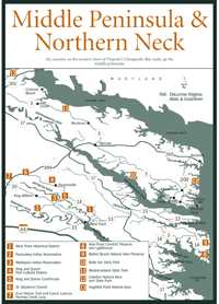
Six counties on the western shore of Virginias Chesapeake Bay make up the
Middle Peninsula. From east to west, they are Mathews, Gloucester, Middlesex,
King and Queen, King William, and Essex. Although the county names have an obvious
British influence, many of the river namesMattaponi, Pamunkey, Piankatank,
and Rappahannockreveal the areas strong Indian heritage.County and town historians
have mapped out several walking and driving tours of historic towns and scenic
counties on the Middle Peninsula. The towns include Gloucester in Gloucester
County, Urbanna and Saluda in Middlesex County, Tappahannock in Essex County,
and West Point in King William County. Both Middlesex and Mathews counties have
booklets outlining driving tours.
The main attraction of the Gloucester Historic Walking Tour is Courthouse Square, with its jail, debtors prison, and courthouse. The old courthouse was constructed in the 1780s and used for 200 years. The current county offices are in the Botetourt Building, which was formerly the Tavern at Gloucester Courthouse, and was built prior to 1774. Also on the tour are other restored buildings, as well as gift shops, antique shops, and restaurants. Gloucester is also known for its Daffodil Festival (804-693-2355), held on the first weekend in April to coincide with the blooming of thousands of daffodils in area gardens and on daffodil farms. Gloucester farms ship daffodil bulbs to destinations worldwide.
Middlesex County is on the northeastern corner of the Middle Peninsula. The Middlesex Heritage Tour has a comprehensive booklet on the driving and walking tours of Saluda, Urbanna, and Middlesex County. The booklet describes the countys older homes and buildings, as well as the lives of the people associated with them.
Urbanna, which is located on the Rappahannock River north of Saluda, served as a port town where tobacco was shipped to England in return for European supplies. The Urbanna Self-Guided Walking Tour has several sites listed on the National Register of Historic Places, including the old tobacco warehouse and the courthouse. The tobacco warehouse, which houses a visitor center, was built in 1766 and is one of the oldest surviving mercantile structures in America associated with the sale of tobacco. Soil of the Middle Peninsula produced high quality, aromatic tobacco that was once used as currency. The town was thriving in the early 1800s, sending local produce and supplies on steamboats to Fredericksburg and Baltimore. Canneries were opened to preserve vegetables and seafood that were shipped to cities up and down the East Coast.
The Courthouse, built in 1748, is one of Virginias 11 Colonial courthouses still standing. The building underwent architectural modifications, serving for a time as an interdenominational church and, during the Civil War, as a confederate barracks. Visitors to the town love to gaze at the ornate Victorian homes constructed during the towns prosperous days as a summer resort and port city.The Urbanna Oyster Festival (804-758-0368), usually held on the first weekend in November when the oyster harvest is at its peak, is one of the Middle Peninsulas most popular events. This out-of-the-way village swells in size by some 80,000 revelers who come to sample oysters on the half-shell, oyster stew, oyster casserole, fried oysters, and oyster fritters, as well as clams, crabs, and other Chesapeake Bay specialties. The festival includes a parade, a fine arts exhibit, and the arrival of tall ships.Deltaville, a Middlesex County fishing village some 17 miles east of Urbanna on VA 33, is the site of two annual rockfish tournaments. The Lower Middlesex Volunteer Fire Department Rockfish Tournament (804-776-6046) is held the weekend before Thanksgiving. The CCA/Greentop Benefit Rockfish Tournament (757-481-1226 or 804-672-1368) is held on the first Saturday in December. Boaters, their families, and visitors come to watch the weigh-in and join in festivities at days end.Tappahannock is located about 30 miles upriver from Urbanna and, like Urbanna, was established as a port city by England in the early 1600s. Captain John Smith, who explored much of the Chesapeake Bay and its tributaries, landed here in 1608, but local Indians drove him back to his ship. The name Tappahannock comes from the Indian Tappahannocke, meaning "on the rise and fall of water."
The Tappahannock Walking Tour takes in 13 homes and buildings with diverse architectural styles of this town that is older even than Richmond and Williamsburg. The sites include Scots Arms Tavern, circa 1680; the Beale Memorial Baptist Church, which was the 1728 courthouse; the debtors prison, built prior to 1769; and the Customs House from the early 1800s.
The Rappahannock River Cruise (800-598-BOAT or 804-453-BOAT) begins on the north side of US 360/17 on Hoskins Creek on the southern end of town. The two-decker Captain Thomas boat takes passengers on the Rappahannock to tour Ingleside Plantation Winery and enjoy the plantations buffet lunch. Bald eagles (Haliaeetus leucocephalus) are frequently spotted along the river.
While in Tappahannock, be sure to stop at Lowerys Seafood Restaurant (804) 443-2800 on US 360/17 on the northwestern end of town. The restaurant has been a local landmark since 1938, serving regional fare such as frog legs, quail, fresh seafood, and homegrown vegetables.
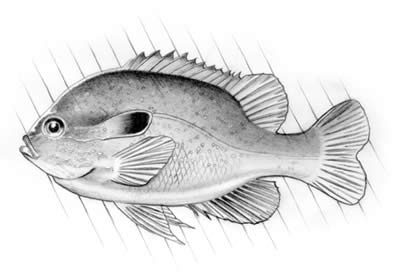
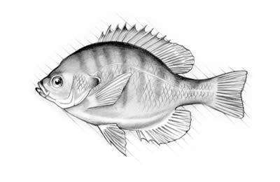
[Fig. 9] The brackish tidal Piankatank has fisheries such as white perch, bluegill, largemouth bass, catfish, and striped bass typical of its larger tidal-river cousins. Upstream, the Piankatank becomes Dragon Run. The Run, as its known by those who float or fish it, is relatively unspoiled and incredibly scenic. The water may be high enough in the nontidal portions to float the river only in the spring, but the trip through mysterious cypress swamps and heavy forest cover is well worth the effort to set time aside. Fish populations include redbreast sunfish, crappie, largemouth bass, bluegill, chain pickerel, and some of the best white perch fishing in the state, especially where Dragon Run widens out in the lower portion. The endangered bald eagle (Haliaeetus leucocephalus) nests here and many unusual warblers find the thick undergrowth to their liking.
Canoeists who discover this quiet waterway take great pleasure in floating remote stretches of river that have not changed much since the Piankatank Indians launched their own boats. History lies even in the rivers names. The Piankatank, meaning "winding waterway," was named by Chief Powhatan, who subdued the Piankatank Indians. Captain John Smith, who sailed up the Piankatank on a mapping expedition, named Dragon Run when he reached the headwaters.
A public boat ramp on the Piankatank is on VA 606 at Freeport in northwestern Gloucester County. Dragon Run is accessible to canoeists at places where the highway crosses the river, but permission to park on the shoulder may be required from adjacent landowners.
Perhaps the best way to become acquainted with King William County and the town of West Point is to follow the Mattaponi-Pamunkey Trail. The Mattaponi River on the northeast side and the Pamunkey River to the south define King William County, which is northeast of Richmond and Hanover County. The rivers merge at the countys southeastern tip at West Point to form the York River.
The Mattaponi-Pamunkey Trail, which is more suggested highway routes than an actual trail, was designed to connect the countys main thoroughfaresVA 30 and US 360with scenic, rural back roads that branch off to historic, cultural, and natural attractions. The main trail is about 30 miles one direction, extending along US 30 from the northwestern border of King William County to the countys southeastern tip, and about 8 miles in another direction, following US 360 across the width of the county. Some of the side branches include all or parts of VA 604, VA 615, VA 600, VA 629, VA 632, and VA 640.
Also on the trail are sites that are on the National Register of Historic Places, such as King William Courthouse at King William, Saint Johns Church at Rose Garden, the Pamunkey Indian Reservation Archaeological District, and the West Point Historical District. A brochure with a detailed description of the trail is available from West Point town offices, King William county offices, or regional tourism offices. Some of the highlights are listed here:
[Fig. 9(1)] By glancing at a map, the strategic location of West Point becomes obvious. The town was formed where the Mattaponi and Pamunkey converge to form the York River. West Point was first an Indian village and then a Colonial plantation, but in the late 19th century it became a busy commercial port and terminus of the Richmond-York River Railroad.
It would be easy to pass through the town on VA 33 and miss the historic district just a half block away. A turn to the east onto Main Street will lead past old homes, shops, churches, the library, town hall, and post officestructures preserved from the late nineteenth and early twentieth centuries. To take the Historic District Walking Tour, visitors can park in the town library lot at 7th and Main streets, then walk along Main Street and parallel Lee Street and the connecting blocks of 1st, 4th, 7th, and 10th. Architectural styles include Victorian Italianate, Queen Anne, and Gothic Revival.
At the eastern end of Main Street (the corner of Main and 1st) is Beach Park on the York River. Facing the York, the Mattaponi River comes in on your left and the Pamunkey River comes in on your right. The park is the former site of the Terminal Hotel, a once-popular destination when West Point was in its heyday.
Direct descendants of Chief Powhatan and his Indian tribe, who once hunted and fished the land that is now King William County, still live here. The Mattaponi Reservation [Fig. 9(3)] (804-769-2229) and Pamunkey Reservation [Fig. 9(2)] (804-843-4740) are each located on the rivers that bear their names. The public is invited to the reservations periodically for cultural events. The Pamunkey Indian Museum (804-843-4792) and the Mattaponi Indian Museum (804-769-2229) display early relics that help with an understanding of tribal culture from the Ice Age to the present. Call ahead for hours.
[Fig. 9] The Mattaponi has the distinction of being one of the cleanest lowland rivers in the Eastern United States. Several rare plants inhabit the marshes of the Mattaponi and Pamunkey rivers. The tropical water-hyssop (Racopa innominata), Parkers pipewort (Eriocaulon parkeri) and marsh senna (Chamaecrista fasciculata) are among examples. Sensitive joint-vetch (Aeschynomene virginica)a globally rare planthas adapted to the tidal channel edges of the freshwater marshes.Anglers know both the Mattaponi and the Pamunkey for their fantastic channel catfish and white catfish action, and for the exciting spawning runs of white perch and herring in the spring. Striped bass, blue catfish, yellow perch, and redbreast sunfish also provide sport for fishermen. Public boat ramps are located on the Mattaponi at West Point (VA 33, Glass Island landing), Waterfence, Melrose, and Aylett. The Aylett landing, located on VA 600 just east of Aylett and US 360, has picnic Facilities and a paved ramp. On the Pamunkey, landings are located at Lester Manor (VA 672, just downstream from the Pamunkey Reservation), and at West Points Beach Park (York River access, corner of Main and 1st streets). The rivers may also be accessed wherever they intersect a road, but landowner permission may be required for parking off the shoulder.
[Fig. 9(7)] The Zoar Nature Trail, Herring Creek Nature Trail, and canoe put-in are on Herring Creek about 2 miles north of Aylett. The parking areas for the trail and launch area are on the eastern side of VA 600, near the creeks confluence with the scenic Mattaponi River on the border of King William and King and Queen counties.The Zoar Nature Trail is a 1-mile interpretive walk through a 29-acre tract of the 378-acre Zoar State Forest. Several wooden bridges and a gentle footpath lead through forested wetlands and dryer woodlands beneath a canopy formed by magnificent beech, oak, and hickory trees that have escaped the lumbermans axe over the years. Evergreens such as mountain laurel and American holly color the woods even in mid-winter. The shorter Herring Creek Loop Trail climbs above Herring Creek. Brochures for the two trails are located at the parking lot trailheads.At the canoe launch area, anglers can be seen during the spring spawning run using dip nets to catch herring. Mattaponi Canoe and Kayak (800-769-3545), an outfitter at Aylett, provides rental canoes and kayaks and guide service. Look for beaver slides along the banks of the Mattaponi.Trails: Zoar Nature Trail is an easy 1-mile loop near the Herring Creek confluence with the Mattaponi River. Herring Creek Loop Trail is a shorter loop of easy to moderate difficulty, with views of Herring Creek.
[Fig. 9(8), 7(16)] This 108-acre Nature Conservancy preserve is located at New Point Comfort at the southern tip of Mathews County. The sensitive habitats protected here include a sandy beach, a salt marsh, and a maritime forest. A handicap-accessible boardwalk with interpretive signs leads into the preserve, where more than 200 bird species have been identified.From the boardwalk observation deck, the New Point Comfort Lighthouse is visible. The lighthouse is on the island at the southern tip of Mathews County, near the entrance to Mobjack Bay. This 63-foot brick tower was completed in 1804, damaged during the Civil War, repaired, and used until the early 1950s. In the 1970s, the lighthouse was named a National Historic Landmark and restored. It is accessible only by water.
[Fig. 9(9), Fig. 7(15)] Several rare species have evolved in harmony with the shifting sands of the beach and low dunes that make up much of this 83-acre preserve fronting the Chesapeake Bay east of Mathews.Least terns (Sterna antillarum), dainty birds with black caps and gray backs, lay their nests in shallow depressions in the sanda trait that leaves them vulnerable to marauding predators and human activity. The federally threatened northeastern beach tiger beetle (Cicindela dorsalis dorsalis) is also found on the beach.The rare sea-beach knotweed (Polygonum glaucum) is well suited to the area behind the dunes where overwash at high tide drains into the inlet behind the spit. Look for a whitish waxy coating on the sprawling blue-green plant. The expansive salt marsh west of the dunes is vital as a filter for sediments and pollution, a buffer from wind and waves, and a nursery for many of the estuarys fish and crustaceans. The marsh is also a nesting site of the northern harrier (Circus cyaneus), which usually nests farther north.Leashed pets are permitted.
A little advance planning might be helpful if you want breakfast or dinner on the Middle Peninsula. Restaurants tend to be few and far between.
Eckhards. VA 3, Topping. German and other foods. Located 1 mile south of the Rappahannock River bridge. Inexpensive to moderate. Phone (804) 758-4060.
Galley Restaurant. Deltaville. Specializes in fresh seafood. Inexpensive to moderate. Phone (804) 776-6040.
Lowerys Seafood Restaurant. 528 Church Lane, Tappahannock. Since 1938, known for fine service and Chesapeake Bay cuisine. Lunch and dinner daily, year-round. Inexpensive to moderate. Phone (804) 443-2800.
Rivers Inn Restaurant and Crab Deck. 8109 Yacht Haven Drive, Gloucester Point. Specializes in fresh seafood. Located on the York River at York River Yacht Haven. Inexpensive to moderate. Phone (804) 642-9942.
Seabreeze Restaurant. Grimstead, Gwynns Island. Typical Chesapeake Bay fare. Waterfront. Come by car or boat. Inexpensive to moderate. Phone (804) 725-4000.
Seawells Ordinary. US 17 (George Washington Memorial Highway), Ordinary. Sample foods from the area at this historic restaurant housed in a 1712 residence. Colonial atmosphere. Inexpensive to moderate. Phone (804) 642-3635.
Virginia Street Cafe. Virginia and Cross Streets, Urbanna. Specializes in regional foods. Inexpensive to moderate. Phone (804) 758-3798.
To best enjoy the Middle Peninsula, come to stay for awhile at one of these accommodations. The peninsula is rich in bed and breakfast inns, which lend themselves perfectly to settling into the rhythm of the seasons and the tides. The New Point Campground (804-725-5120) at New Point in Mathews County has hookups, a beach, boat rentals, a marina, and a pool. Campgrounds are also located at Gloucester Point, New Point, Gwynns Island, Deltaville, Topping, Urbanna, and King and Queen Courthouse. A complete list of hotels, motels, B&Bs, and campgrounds is available by calling the Middle Peninsula Travel Council at (800) 217-8912.
Airville Plantation. 6423 T. C. Walker Road, Gloucester. National Historic Register plantation with period furnishings, working fireplaces, a pool, a beach, fishing, and a deepwater dock. Expensive. Phone (804) 694-0287.
Days Inn. US 17, Tappahannock Boulevard, Tappahannock. Restaurant nearby. Inexpensive to moderate. Phone (804) 443-9200.
Dockside Inn. Highway 33, Deltaville. Efficiencies with small refrigerators and microwaves. Inexpensive to moderate. Phone (804) 776-9224.
Dragon Run Inn. US 17 and VA 602, Church View. A 1913 country farmhouse converted to a B&B . The house was built with cypress from the Dragon Run swamp. Moderate. Phone (804) 758-5719. Web site www.dragon-run-inn.com.
The Inn. 250 Virginia Street, Urbanna. Spacious rooms; formal and casual dining. Phone (804) 758-4852.
Islander Motel. Gwynns Island. Waterfront location in a sheltered harbor with a marina and a restaurant. Pool, beach, tennis courts. Moderate. Phone (804) 725-2151.
Read and add comments about this page