 John
Muir Trail John
Muir Trail
John
Muir Trail John
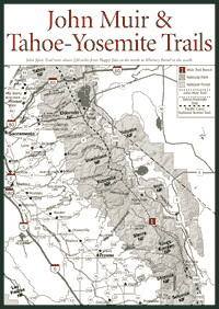
Muir Trail [Fig. 61] Hikers and backpackers come from around the globe to hike the John Muir Trail. There are some days on the Muir Trail when hikers hear only foreign languages and the sounds of nature. In fact, the Muir Trail's pristine granite scenes—at an average elevation of 9,000 feet and miles from any civilization—are sometimes crowded.
The trail runs about 220 miles from Happy Isles in the north to the Whitney Portal in the south. The official southern terminus of the trail is considered to be the top of Whitney at 14,497 feet, which makes the trail closer to 212 miles. But to leave the mountains, hikers must walk down to Whitney Portal on the Eastern Sierra. About 177 miles of the Muir Trail coincides with the Pacific Crest Trail.
On the trail, hikers walk along the Sierra spine through three national parks and two national forests. Besides Yosemite, the trail cuts through a large portion of Kings Canyon National Park and a smaller part of Sequoia National Park. It runs through Sierra and Inyo national forests.
Many people plan and hike the entire length in three weeks to a month. With new ultralight backpacking methods, some prefer to walk it in 17 or 18 days. Others like to hike parts of it over a number of summers. No matter which approach people choose, the Muir Trail is considered a true collector's item among people who bag long-distance hikes.
Photography is one of the biggest passions of hikers along the Muir Trail. For those who surf the Internet, type "John Muir Trail" into your search engine and see the eye-popping Muir Trail photographs loaded onto many personal pages.
There are literally thousands of placid glacial lakes displaying mirror images of jagged granite peaks and snow-rimmed cirques. Hikers spend a lot of time above timberline, where vegetation is sparse and the views are sweeping and wide. And at the rooftop of California, the skies are much deeper blue and much clearer than anywhere else in the state.
State and federal officials recognized the significance of the trail in the nineteenth century. It was explored and mapped by several men. Joseph LeConte, Theodore Solomons, and Bolton Brown are credited with doing much of the early exploration. Solomons is considered the person who provided the inspiration for the trail. The National Park Service and the U.S. Forest Service began cutting the trail in 1908 and finished it eight years later.
These days, the trail is pretty easy to follow, though a good topographic map and a compass are always recommended in the backcountry. Many backpackers prefer to walk from Yosemite south to Whitney because the climb up Whitney at the start of the trek is grueling. Starting from Whitney, you gain more than 5,000 feet—about 1 mile—in elevation over about 8 miles. In Yosemite, you climb almost 6,000 feet, but it is spread over 16 miles.
Either way, this is one hike that requires physical conditioning. But, as Muir himself said in his wilderness essays: "How glorious a greeting the sun gives the mountains! To behold this alone is worth the pains of any excursion a thousand times over."
Some people prefer starting from Whitney anyway, because it allows them the safety of approaching steep passes from the south. The southern faces normally have less snow and ice early in the season. The travel season for the Muir Trail is July through October, but the snow does not fully melt until August in places higher than 12,000 feet. Be ready for thunderstorms and even snow in July or August.
Wilderness permits are required for any overnight stay, so contact ranger stations in advance. For people hiking all the way through the Muir Trail, restocking food supplies is a major concern because there is no easy access to stores or towns along much of the trail. In some places, it will take hikers more than a day to hike out of the backcountry.
There are two small stores near the trail at Reds Meadow near the Devils Postpile National Monument and Tuolumne Meadows in Yosemite. Hikers can mail food packages to Vermillion Valley Resort at Thomas Edison Lake and Muir Trail Ranch at Florence Lake in the Sierra National Forest. Vermillion and the ranch will hold the packages for a specified time and give them to hikers. But there's about a 60-mile stretch in Kings Canyon National Park where there are no quick exits to the trail.
Here are the addresses for mailing food packages: Vermillion Valley Resort, PO Box 258, Lakeshore, CA 93634. Phone (559) 259-4000 (in spring and summer), (559) 855-6558 (office). Muir Trail Ranch, Box 176, Lakeshore, CA 93634 (in spring and summer). The ranch has no telephone. In fall and winter, write to PO Box 269, Ahwahnee, CA 93601. Phone (209) 966-3195.
[Fig. 61(1)] The Muir Trail Ranch is at the midpoint on the John Muir Trail; from here it's 109 miles north to Happy Isles and about 109 miles south to the Whitney Portal. Hikers can stop to buy matches or batteries at a small store at the ranch, which is only 0.25 mile from the Muir Trail.
Guests here enjoy horseback riding, short hikes, or fishing. Muir Trail Ranch, located in the John Muir Wilderness, is a place to get away from the daily grind. There are no telephones, but the ranch stays in contact with the outside world via two-way radio. The comforts of a warm bed and an indoor bathroom are available in the log cabin accommodations, but many visitors choose to camp. There are also two enclosed natural hot spring baths available. And for views, just look up to Ward Mountain at 10,862 feet across the San Joaquin River from Blayney Meadow on the ranch.
Read and add comments about this page