 Ansel
Adams Wilderness Ansel
Adams Wilderness
Ansel
Adams Wilderness Ansel
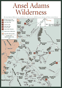
Adams Wilderness [Fig. 40] The Ansel Adams Wilderness is named for the landscape photographer whose wilderness portraits of Yosemite National Park and the Sierra Nevada have been acclaimed internationally. The wilderness, established in 1985, covers 228,500 acres in the Inyo and the Sierra national forests.
It is considered an important ecological area because it contains the headwaters of the 350-mile San Joaquin River, the state's second longest river. The San Joaquin starts at Thousand Island Lake, above 10,000 feet in elevation, and runs to the Central Valley. Its 1.7 million acre-foot annual runoff passes through more than 25 powerhouses, which produce hydroelectric power for Southern California Edison.
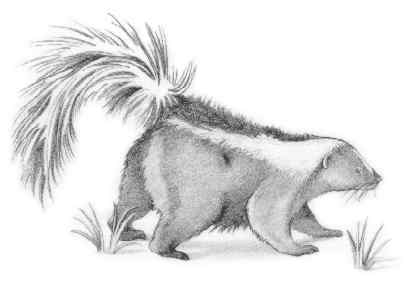
Along the river are stands of red fir (Abies magnifica) and Jeffrey pine (Pinus jeffreyi). Visitors also will see mountain hemlock (Tsuga mertensia) and quaking aspen (Populus tremuloides). The wildlife include the panamint kangaroo rat (Dipodomys panamantinus), striped skunk (Mephitis mephitis), and porcupine (Erethizon dorsatum).
But land at the high elevations—ranging between 7,600 feet and 13,000 feet—is barren granite. The granite formed about 80 million years ago. Erosion of volcanic and metamorphic rock over the next 20 million years exposed the Sierra Granite, which existed as lowland compared to today's soaring mountains.
The tilting and uplifting of the Sierra began 20 million to 30 million years ago. The San Joaquin's headwaters may have been as far east as Nevada. But the Sierra rose high enough to block the ancient channel from the east, and the river's headwaters became suspended near the crest at Thousand Island Lake.
After three pulses of uplift over more than 20 million years, Ice Age glaciers 2 million years ago began to widen river and creek canyons with tons of slow-moving ice. They created cirques and scarred gorges when they departed. Some small glaciers remain on the north- and north-east facing peaks, especially in the Ritter Range near the Devils Postpile National Monument.
The retreating glaciers left many lakes, which are considered to be fishing paradises. The wilderness has excellent stream and lake fishing for rainbow (Oncorhynchus mykiss), golden (Salmo aguabonita), and Eastern brook trout (Salvelinus fontinalis). The lakes include Gem Lake, Parker Lake, Waugh Lake, and Minaret Lake, but there are dozens of others.
 Hikers,
backpackers, fishing enthusiasts, and snow skiers should be aware of the
dramatic weather in the Sierra, especially above 9,000 feet in this part
of the range. A few puffy clouds on the horizon can become a drenching thunderstorm
in less than an hour. During storms, avoid open areas such as meadows, ridges,
and mountaintops, and stay away from water and isolated trees.
Hikers,
backpackers, fishing enthusiasts, and snow skiers should be aware of the
dramatic weather in the Sierra, especially above 9,000 feet in this part
of the range. A few puffy clouds on the horizon can become a drenching thunderstorm
in less than an hour. During storms, avoid open areas such as meadows, ridges,
and mountaintops, and stay away from water and isolated trees.
Blizzards also develop rapidly any time of year, but especially in late fall, winter, and spring. Carry extra food, parkas, and dry clothing when taking a trip of more than one day. The best time to hike the Ansel Adams Wilderness is from June through September. Some access roads close after the first snowfall in autumn and do not reopen until late May or June.
[Fig. 40(1)] Anyone who makes the tough hike to this alpine lake should be wearing insect repellant. The mosquitoes in late June, July, and early August are everywhere. The views of Walker Creek and Walker Lake along the hike make the walk interesting. Lower Sardine Lake is a small, deep glacial tarn filled with cold water and trout.
On the way to Lower Sardine, hikers will see Indian paintbrush (Castilleja campestris), quaking aspen (Populus tremuloides), white fir (Abies concolor), and lupine (Lupinas lepidus). The route is called Bloody Canyon Trail, which refers to the first time explorers with horses tried to traverse it. The sharp rocks cut their horses so badly that the trail was sprinkled with blood.
 At
Lower Sardine, alpine wildflowers look dazzling on the shoreline. Look for
the alpine paintbrush (Castilleja nana), alpine goldenrod (Solidago
multiradiata), and Drummond's cinquefoil (Potentilla drummondii).
At
Lower Sardine, alpine wildflowers look dazzling on the shoreline. Look for
the alpine paintbrush (Castilleja nana), alpine goldenrod (Solidago
multiradiata), and Drummond's cinquefoil (Potentilla drummondii).
The view from the lake includes the Owens Valley and Mono Lake. At this elevation, visitors can expect to also see the gray-crowned rosy finch (Leucosticte tephrocotis). This bird is commonly seen in flocks feeding on seeds and insects next to alpine lakes and even near snowbanks on ridgecrests.
Aside from fishing and hiking, photography is one of the big lures of Lower Sardine Lake. The glacially sculpted cliffs and waterfalls in the area make an excellent backdrop for photographers who want to capture views of the Sierra crest.
[Fig. 40(2)] The lake, named by Theodore Agnew during the mining days of the late nineteenth century, is nestled on a granite bench with soaring peaks around it. Hikers can see Carson Peak (10,909 feet) to the east and Mount Lyell (13,114 feet) to the west. Blacktop Peak (12,710 feet) and Mount Wood (12,637 feet) rise in the distance to the north.
Gem Lake is a hydroelectric reservoir owned by Southern California Edison. But miners recognized it immediately for its beauty and photogenic location among the peaks in what would become the Ansel Adams Wilderness. It was quickly known as "Gem o' the mountains."
The flora is also striking at Gem Lake. Look for the edible fruit of the dwarf huckleberry (Vaccinium nivictum). Small rodents in the area feed on this plant, which is fairly common in moist soils above 7,000 feet in the Sierra.
Hikers have to walk uphill a long way to see these sights. There is a 1,300-foot gain in elevation in the first 2.5 miles, so be prepared take a little time, especially this high in the Sierra.
[Fig. 40(3)] Two 13,000-foot peaks, Mount Ritter and Banner Peak in the Ansel Adams Wilderness, dominate the view around Shadow Lake. The stunning views are the main reasons to climb the trail into this lake, which is surrounded by Jeffrey pine (Pinus jeffreyi), lodgepole pine (Pinus murrayana), and red fir (Abies magnifica). Along the streams in the area, look for the black cottonwood (populus trichorcarpa) and the Fremont cottonwood (Populus fremontii).
The understory plants in the coniferous forest include herbaceous vegetation in the Eastern Sierra. The plants are not abundant but they are apparent. In this area, look for the white-veined wintergreen (Pyrola picta), western prince's pine (Chimaphila umbellata), and spotted coralroot (Corallorhiza maculata).
This hike is not a long day hike, but it requires a fair amount of climbing. Take it slowly and bring plenty of water or a water pump to purify the water you find in streams or the lake. No surface water in the Sierra is considered safe from contaminants.
Read and add comments about this page