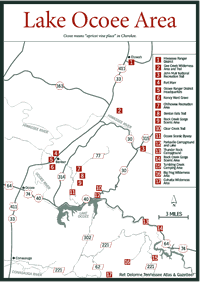
[Fig. 38(5)] The Ocoee Ranger District (94,628 acres) is the southernmost ranger district in the Cherokee National Forest (CNF) in the extreme southeastern corner of Tennessee. This district offers camping, boating, fishing, hiking, biking, horseback riding, rafting, kayaking, picnicking, and swimming. The district contains Chilhowee Recreation Area, Rock Creek Gorge Scenic Area, Little Frog Wilderness Area, Big Frog Wilderness Area, and Cohutta Wilderness Area.
Ocoee means "apricot vine place" in Cherokee. It is thought the apricot vine refers to the passion flower plant (Passiflora incarnata), also called maypop. The globular fruit, when squeezed, may pop or it may not, hence, maypop. The seeds in the fruit are covered with a sweetish, fleshy pulp when ripe in late summer.
The Ocoee Scenic Byway was the first National Forest Byway in the nation. The route includes 19 miles of US Highway 64 and 7 miles of FR 77 going up Chilhowee Mountain in Polk County. This route was designed to take motorists through some of the most beautiful areas in east Tennessee. It includes natural beauty, many popular recreation spots, and the opportunity to view historic sites. Visitors can see over the Tennessee Valley to the Cumberland Plateau and to the Blue Ridge province. On a clear day, North Carolina and Georgia are visible, and the Ocoee Scenic Byway offers excellent views of nearby Sugarloaf Mountain. On Chilhowee Mountain visitors will find Chilhowee Recreation Area with campground, lake, swimming area, picnic grounds, and trails.
The Cherokee National Forest is rich with history. This area has been inhabited for over 12,000 years. The Cherokee Indians used to make their home here and the hills are filled with their history and culture. Much later, armies flowed through the valleys near here during the Civil War. A handful of Confederate soldiers were surprised by Union troops one night on Chilhowee Mountain. Their camping spot is marked next to the byway.
The scenic byway traces its way along parts of the Old Copper Road that used to follow some of the route of US 64. Horse-drawn wagons followed the road to transport a wealth of high-grade copper ore from Copperhill and Ducktown down the Ocoee River gorge to railway cars in Cleveland. It was not unusual for men working the wagons to spend the night at the Halfway House located near the mouth of Greasy Creek at Parksville Lake. The next day, they would complete the two-day journey from Copperhill to Cleveland. Parts of the old inn are under the waters of Parksville Lake.
The Ocoee River originates from the Toccoa River that flows from the north Georgia mountains into Ocoee Lake Number Three. The river's name changes from Toccoa River to Ocoee River at the state line near Copperhill.
As a free-flowing, whitewater river, it carved out the Ocoee Gorge. Today
the water power is harnessed for hydroelectricity and recreation in the form
of calm lakes. Whitewater occurs only when water is released through the dams.
The eastern dam, Ocoee Dam Number Three, is between Big Frog and Little Frog
wilderness areas; the middle dam, Ocoee Dam Number Two, is at Caney Creek;
and the western dam, Ocoee Dam Number 1 (also called Parkville Dam), is at
the western edge of the district, south of Benton near the junction of US 64
and TN 314.

There were no roads in the Ocoee River gorge at the time of the Cherokee Indian removal in 1838, and the basin (Copperhill area) was also inaccessible. This land had few white settlers and was the land no one wanted until copper was discovered here in 1843. This discovery marked the demise of the rich soil, lush forests with huge trees, and green rolling mountains.
John Caldwell moved to Ducktown in 1849 with the idea to build a 33-mile road connecting Cleveland with the copper-producing area. The Copper Road, completed in 1853, doomed the environment to exploitation and ruin for financial benefit. This exploitation did bring livelihoods to many people. In the 1930s, US 64 was built using the old Copper Road route, except for about a 2.5-mile stretch that moved away from the Ocoee River.
The Civil War ceased the operation except for some small amount of mining and smelting to benefit the Confederacy. By 1876 all the wood in the area had been cut to fuel the smelters, and wood had to imported from surrounding areas. Two years later mining and smelting stopped after producing 24 million pounds of copper. Fifty square miles of trees had been cleared for fuel. It was again the land no one wanted—raw, infertile dirt piles, appearing much like one imagines the moonscape to look.
In 1899, the Tennessee Copper Company started the Burra Burra mine and operated it until the last mine closed in 1987. In the 1930s government agencies and copper companies began to revegetate the 23,000 acres of polluted and eroded land. Today, most of the moonscape is green.
The Tennessee Electric Power Company looked upon the Ocoee River as a source of inexpensive hydroelectric power, and it began construction of the Parksville Dam south of Benton in 1910. The completion in 1911 gave the Ocoee River its first lake, Parksville Lake, also called Ocoee Lake. Parksville Dam is built on top of the Great Smokey Fault, where older rock was shoved over younger rock. This is the place the Blue Ridge province meets the Valley and Ridge province.
In 1912, construction began on Ocoee Dam Number Two at Caney Creek. Construction began in 1941 on Ocoee Dam Number Three, and the dam became operational in 1943. Ocoee Dam Number Three funnels water into a 2.5-mile tunnel cut through the rock on the western side of the river that goes downstream to Powerhouse Number Three. In 1939, the Tennessee Valley Authority (TVA) took control of the Ocoee system.
When a 5-mile wooden flume that carried water from the Ocoee Number Two Diversion Dam downstream to Powerhouse Number Two needed repair in 1976, the water was released into its natural river bed. This became the whitewater portion of the Ocoee River. The river ran wild, attracting whitewater rafters, kayakers, and canoeists. This area gained much attention, as word spread among whitewater enthusiasts.
This led to a confrontation between whitewater enthusiasts and TVA when the flume was repaired and operational. The whitewater area dried up. A compromise resulted in TVA releasing water at certain times to please those needing the swift water for their sport. The flume is on the National Register of Historic Places.
The Ocoee River was the site of the 1996 Olympic Slalom Canoe/Kayak events. The flow at the Ocoee Whitewater Center is about 1,400 cubic feet per second (cps). This is awesome power. Imagine 44 times that much water, 62,000 cps, moving through here. That was what the gauging station measured at Powerhouse Number Two on November 19, 1906 during a flood.
The Ocoee Whitewater Center is 1,500 feet long below Ocoee Dam Number Three. TVA releases water from the dam to generate the whitewater for sporting activities. Call TVA at (800) 238-2264, and when prompted, press 5 on a touch-tone phone for the Ocoee River dams release schedule.
[Fig. 38(11)] The first Forest Service scenic byway in the nation, Ocoee
Scenic Byway, is located in Polk County on sections of US 64 and Forest Route
FR 77 up Chilhowee Mountain in the southern Ocoee District. From Parksville
go east on US 64 then turn left (north) on FR 77. This 26-mile, two-lane highway
winds through scenic rock bluffs of the Ocoee River gorge and past the site
of the 1996 Olympic canoe and kayak competition.

A side trip up Chilhowee Mountain is a 3-mile climb up FR 77 offering many opportunities to survey the valley lands, the Cumberland Mountains, and some of the north Georgia mountains.
TN 68 is another scenic drive through the southern Appalachian countryside. The drive passes along Coker Creek to the community of Coker Creek, then through Turtletown and Dogtown, then within view of Little Frog Mountain and Big Frog Mountain, and then to Ducktown. If towns with animal names aren't enough, TN 68 takes you to a town named after a mineral, Copperhill.
[Fig. 38(7)] Chilhowee Recreation Area has the most developed areas in the CNF and is an excellent place for families. It offers just about all outdoor recreational activities. It has nine trails, including one that leads to magnificent Benton Falls and another that is a watchable wildlife trail, and Lake McCamy is available for fishing, swimming, and boating. McCamy was one of the early and best-known settlers in this area, and he helped build Benton Springs Road up Chilhowee Mountain.
The Chilhowee Trail Complex contains many interconnected trails: Azalea (2 miles), Arbutus (0.7 mile), Red Leaf (0.3 mile), Clear Creek (5.4 miles), Benton Falls (1.6 miles), Scenic Spur (1.7 miles), Clemmer (3 miles), Slickrock (5.1 miles), and Rimrock (4.5 miles). All trails welcome bikers except the Scenic Spur Trail.
The Arbutus Trail, in the campground area, is the watchable wildlife trail that goes through hardwood and white pine regeneration areas and through a grassy opening and tracking pits. This trail takes about 45 minutes to walk and shows how the different types and ages of forests provide habitats for a variety of plants and animals. Along the trail you can see animals from insects to white-tailed deer and birds. Depending on the season, summer tanagers (Pirangra ruba), black-throated green warblers (Dendroica virens)), golden-crowned kinglets (Regulus satrapa), pine warblers (Dendroica pinus), and Carolina chickadees (Parus carolinensis) visit the area.
The two tracking pits, also called bait stations, are baited to attract animals onto the sandy area so they will leave their tracks. It's fun to see how many animals visit the area and how many you can identify. Some of the critters that show up regularly include raccoon, opossum, gray fox (Urocyon cineroargenteus), and wild hog. Deer, turkey, rabbit, squirrel, mice, and a variety of birds may leave their tracks also.
[Fig. 38(8)] Benton Falls Trail (#131) begins at McCamy Lake dam. The waterfall is about 1.5 miles down along the trail. Most of the trek is easy but there is a steep section where extra care is needed.
Benton Falls is fan shaped and tumbles from a rock ledge down the face of the rock onto another rock face. From top to bottom the water falls about 65 feet before entering a small plunge-pool. This is a worthwhile walk and be sure to carry a camera.
[Fig. 38(10)] Clear Creek Trail (#79) starts at State Highway 30. From there it leads west and then south to the northern end of the Rock Creek Gorge Scenic Area to run along the eastern boundary of the scenic area. From midway down the scenic area the trail turns west and then southwest to finish on FR 30 near Parksville Lake.
[Fig. 38(9)] Just southwest of Chilhowee Recreation Area is the 220-acre Rock Creek Gorge Scenic Area. It was designated a scenic area in 1965 to protect this area because it had become too popular with tourists.
Rock Creek flows south through the gorge and has 11 waterfalls. One waterfall cascades over 175 feet of rock and another drops about 60 feet vertically from a ledge.
There is no road to Rock Creek Gorge Scenic Area. Benton Falls Trail and Clear Creek Trail lead from Chilhowee Recreation Area to the northern end of the scenic area.
[Fig. 38(12)] Parksville Campground and Lake offers another major family camping attraction, in addition to the Chilhowee Recreation area, in the Ocoee Ranger District. Although there are no listed trails in the camping area, many are nearby. The large Parksville Lake, also called Lake Ocoee, is just south of the campground across US 64.
[Fig. 38(13)] Thunder Rock Campground on the upper Ocoee River is near the put-in for whitewater sports and the Whitewater Center. This is a popular spot for those looking for whitewater action.
[Fig. 42(1)] Beautiful seems to be the best word to describe the 4,666-acre Little Frog Wilderness Area. Bound by US 64 to the south and the Ocoee/Hiwassee ranger districts boundary to the north, this wilderness takes its name from Little Frog Mountain, which provides the eastern boundary. The highest point in the wilderness area is 3,322 feet above sea level, but depending on which map you use, it has different names. Some call this high point Sassafras Knob, others label it Little Frog. The lowest point is near the Ocoee River which flows parallel to US 64 at Powerhouse Number Three.
Little Frog Wilderness, in spite of being located only 4 miles from the once lethal Copper Basin, fared well while much of the surrounding areas were damaged by the air pollution. This good fortune was attributed to the protection of Little Frog Mountain and prevailing winds. The area, however, did not escape logging during the time of the copper mining and smelting. It is now covered with second growth.
Rock Creek Trail (#125), the only trail in the area, goes through the prettiest and wildest part of the wilderness, Pressley Cove. Little Frog Mountain to the east and Dry Pond Lead to the west form the cove.
[Fig. 42(2)] Rock Creek Trail (#125) leaves US 64 leading into the beautiful valley between two ridges. Flame azalea, rhododendron, mountain laurel, hemlock, trailing arbutus, redbud, toothwort (Dentaria diphylla), and crested dwarf iris are among the many plants along the winding trail. Several feeder creeks cross the trail. Look for the crested dwarf iris along the creek banks. A trek to the rhododendron thickets when they are in bloom is worthwhile. Occasionally, large hemlocks that escaped cutting loom overhead. If it's quiet, turkey, deer, a variety of birds, including the pileated woodpecker (Dryocopus pileatus), and other animals may come into view.
At 4 miles along the trail is the stunning, swift-running Rock Creek. It is here that this trail grants the feeling of peaceful isolation. Few other places revive the spirit like this.
Rock Creek is about 10 feet wide and usually less than 1 foot deep. The trail runs along the creek for a short distance, but long enough to pass a small waterfall about 5 feet high. Rock Creek Trail ends at the junction with Dry Pond Lead Trail. Instead of backtracking to the Rock Creek trailhead, turn left (south) for a 2-mile walk back to US 64 across from Powerhouse Number Three, which is 4 miles west of the Rock Creek trailhead via US 64.
[Fig. 39] The Big Frog and Cohutta wilderness areas' combined total of 45,111 acres in Tennessee's Cherokee National Forest and Georgia's Chattahoochee National Forest makes this the largest wilderness tract in the eastern United States. Big Frog Wilderness Area contains 7,986 acres in Tennessee and 83 acres in Georgia, and Cohutta Wilderness Area contains 1,795 acres in Tennessee and 37,042 in Georgia.
In the Big Frog Wilderness Area, Big Frog Mountain reaches 4,224 feet elevation, the highest point in Polk County, and rules the Ocoee Ranger District's skyline. Looking at a map, Big Frog Wilderness forms a steep arch from the Georgia border, listing slightly to the east. The Tennessee portion of the Cohutta Wilderness Area is a small bump under Big Frogs' southwestern corner. Cohutta Wilderness Area has no trails but Big Frog Wilderness Area is crisscrossed with them.
The rarest type of trail found in the eastern United States, the perfect contour trail, follows a contour line, the imaginary line connecting points with the same elevation. In the Big Frog Wilderness Area, a perfect contour trail follows along a 50-degree slope on the Big Creek (#68)/Barkleggin (#67) Trails. The Civilian Conservation Corps (CCC) laid out this trail along the base of Big Frog Mountain using a surveyor's compass and stretching string lines. The CCC created most of the trails here in the 1930s.
Other trails in the Big Frog Wilderness Area, Licklog, Wolf Ridge, and The Big Frog, predate the CCC by 15 years or more. The Forest Service says that Big Frog Mountain's trails are among the best and most extensive in the CNF. The dozen trails totaling over 40 miles are marked and easy to follow. However, unlike other areas in the CNF, Big Frog Wilderness Area provides little water, requiring hikers to carry their own.
There are no roads in the wilderness areas but access is available via FR 221 and FR 62, which parallels the arc of these areas. Bear signs are common in the wilderness areas because of Tennessee Wildlife Resource Agency's re-introduction program initiated in the 1970s. Bears from the Great Smoky Mountain National Park (GSMNP) were imported into a 52,825-acre bear reserve. Old orange and black wildlife management area signs still exist in the area.
This area was also restocked with deer but their numbers remain low. Wild hogs, on the other hand, are well represented. Farmers used to give their domestic pigs free rein, allowing them to fend for themselves in the forests. These pigs were often marked, but some escaped the identifying brand. Russian hogs trapped in the GSMNP and released here bred with domestic stock. Their offspring look more like the black Russian parent with sharp, prominent tusks. Turkey and bobcats inhabit the area, as do timber rattlesnakes (Crotalus horridus) and copperheads (Agkistrodon contortrix).
Several plant studies conducted in the Big Frog Mountain area found, in addition to the usual trees and plants of the CNF, white pine and several rare plants: catchfly (Silene noctiflora), cow parsnip (Heracleum maximum), rattlesnake root (Prenanthes alba), and bush honeysuckle (Diervilla sessilifolia). A survey identified 479 species of plants with 22 being non-natives. Because humans are one of the major ways exotic species enter an area, this small number of non-native species indicates little human intrusion in this area. Unlike most of the Unaka Range that is considered to be in the Canadian zone for plants, the Ocoee District is not. But high annual rainfall and the mountainous terrain provide the habitat needed by Canadian zone flora.
[Fig. 39(7)] The Tumbling Creek Camping Area is an isolated camping area just east of Big Frog Wilderness Area. Tumbling Creek runs into Ocoee Lake Number Three. This is a nice place for those looking to get away from it all, but this area is not recommended for trailers.
Flowing from northern Georgia into Tennessee, the Conasauga River then weaves back and forth a couple of times across the border before heading west out of the Ocoee Ranger District and dipping back into Georgia. When the water level is high enough, it is an easy stream for canoeists. Its waters carry 22 fish species that have yet to be found anywhere else in Tennessee. The Trout Unlimited organization listed the Conasauga River among the best 100 trout streams in the nation.
Under the 1988 CNF Management Plan the Conasauga River is a protected corridor. This plan safeguards areas with high visual sensitivity and a high degree of public interest, and generally prohibits timber harvesting.
The river ranges from 50 to more than 100 feet wide with some rapids and slow pools. A few large hemlocks, small hardwoods, and pines grow along the banks. Steep escarpments on both sides sometimes shadow the river. Canoeists will need to concern themselves with rocks and rapids, but the view is wonderful. Bear, deer, wild hogs, and many small animals may be seen streamside. Signs of beaver are evident. Canoeists have said the Conasauga River is among the most beautiful rivers you could paddle.
Two major rapids lie between the put-in point on FR 62 and the take-out point on US 411. Scout these before attempting to float through them.
Those willing to brave the cold water will find underwater viewing exceptional in the Conasauga River. A mask and snorkel are all you need to catch a glimpse of 65 fish species, including rainbow trout, brown trout, blue shiner (Cyprinella caerulea), amber darter (Percina antesella), Conasauga logperch (Percina caprodes), and an extraordinary community of mussels. The best underwater viewing is possible when it hasn't rained for several days.