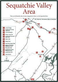
[Fig. 15] The Sequatchie River extends for almost the entire length of the Sequatchie Valley, beginning at Devil Step Hollow Cave in Cumberland County and ending at its confluence with the Tennessee River below Nickajack Dam. There are 60 floatable miles of water, designated as Class I, which meander through farmlands and woodlands between College Station and US 64 bridge. There is also good fishing potential with smallmouth bass, rock bass (Ambloplites rupestris), and rainbow trout (Salmo gairdneri) as the principal species.
The highways generally follow the river all the way through the valley. US 127 parallels it from Pikeville to Dunlap, and TN 28 from Dunlap to Jasper.
[Fig. 17] From 1902 to 1927, Dunlap was the site of 268 coke ovens that turned coal into coke, fuel for the smelting of pig iron. The coke was sent to Chattanooga's foundries that transformed pig iron into steel. The beehive-shaped brick ovens, 12 feet in diameter and 6 feet high, were built by the Chattanooga Iron and Coal Company and employed 350 men. Today the ruins of the ovens, which are on the National Register of Historic Places, stand in a 62-acre forest in Coke Ovens Park in Dunlap. Dunlap is at the junction of US 127 and TN 28 in the Sequatchie Valley.