 The
Blue Ridge Parkway in the Nantahala Mountains The
Blue Ridge Parkway in the Nantahala Mountains
The
Blue Ridge Parkway in the Nantahala Mountains The
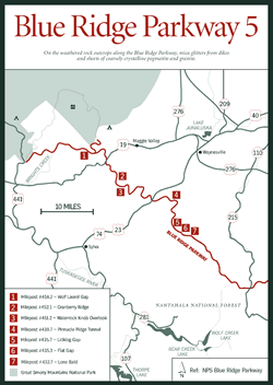
Blue Ridge Parkway in the Nantahala Mountains [Fig. 30] The Blue Ridge Parkway reached its highest point at Richland Balsam Overlook, but now it begins gradually winding down toward its terminus. Anyone who has spent time on the Parkway can attest to feeling a growing sadness as the scenic highway comes to an end. Rest assured, though, that the trip remains exciting to the last mile.
Lone Bald, milepost 432.7 [Fig. 30(7)], once had a lone red spruce (Picea rubens) growing atop. When the tree fell, the name changed to Lone Bald. Over the years, though the area has sprouted low shrubs and a variety of trees, the name still stands.
Flat Gap, milepost 435.3 [Fig. 30(6)], offers views of Doubletop Mountain and the historic site of the Cherokee village Tuckasegee (Tsi-ksi-tsi) along the river below. The name is said to mean "terrapin place," referring to the slow pace of the river here. There was nothing slow, however, about the attack of 150 American soldiers who in 1781 destroyed the village during the Revolutionary War. The Cherokee were allies of the British.
Licklog Gap, milepost 435.7 [Fig. 30(5)], is said to have once hosted its namesake, the licklog—a log with holes cut in it by herders and filled with salt for cattle. Twenty-three miles down the Parkway, Lickstone Ridge, milepost 458.9, earned its name from something similar—the lickstone. A stone instead of a log was used as a place for the cattle's supply of salt.
At milepost 439.7, Pinnacle Ridge Tunnel [Fig. 30(4)], the first of six tunnels in this section, runs 895 feet long. Sherrill Cove Tunnel, milepost 466.3, the last tunnel (or first if starting near Cherokee) on the Parkway, cuts through 590 feet of mountain. At the Waterrock Knob Overlook, milepost 451.2 [Fig. 30(3)], the namesake mountain sits astride both the Plott Balsams and the Great Balsam ranges. Waterrock Knob offers a 360-degree panorama of the most spectacular proportions: the Great Balsams, Great Smokies, Cowees, and Nantahalas. The Newfound, Blacks, and Craggies are all visible on a clear day. A plaque at the overlook recognizes H. Getty Browning, who led a well-researched campaign to route the Parkway through North Carolina rather than share it with neighboring Tennessee. Nearby Browning Knob was named in his honor.
Cranberry Ridge, milepost 452.1 [Fig. 30(2)], is named for the small cranberry (Vaccinium oxycoccos) that grows along the higher-elevation slopes. Small pinkish flowers of this creeping, woody perennial bear edible red berries in late summer and early fall, especially popular with wildlife.
At Wolf Laurel Gap, milepost 458.2 [Fig. 30(1)], a spur road carries travelers to the Mile-High Overlook and a spectacular view of the Smokies and the Balsams, teasing travelers with the majestic peaks that lie ahead in the Smokies: Clingmans Dome, Mount LeConte, Mount Kephart, and Mount Guyot. The spur road continues past a view of Maggie Valley below and of Lake Junaluska, a lake named in honor of the Cherokee warrior who first fought against the European settlers and later became their ally in the War of 1812. Andrew Jackson swore his gratitude to Junaluska, yet later as president he signed away the rights to the Cherokee's homeland, and the tragic Trail of Tears ensued (see Qualla Boundary).
The remaining miles of the Parkway are steeped in Cherokee legend as they wend their way toward the terminus at milepost 469, elevation 2,000 feet. True to its grand nature, the Blue Ridge Parkway doesn't just peter out but delivers its visitors to the natural beauty and native bounty of The Great Smoky Mountains National Park and Qualla Boundary of the Cherokee Indians, a noteworthy finale for this magnificent highway.