 The
Pisgah National Forest The
Pisgah National Forest
The
Pisgah National Forest The
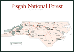
Pisgah National Forest [Fig. 24] Anyone who has visited the lush forests of Western North Carolina would agree—it was a logical place to start securing public lands after the passage of the Weeks Act of 1911. The act was a Congressional response to the public outcry to restore forests endangered by wasteful logging and the ravages of fire and erosion. In 1912, when Congress authorized the first purchase east of the Mississippi, 8,100 acres on Curtis Creek (see Curtis Creek, page 93), Pisgah National Forest was born. Pisgah National Forest and Nantahala National Forest, the other national preserve in North Carolina's mountains, are two of the four national forests statewide.
Over the years, new lands were acquired but none more significant than the nearly 87,000 acres Edith Vanderbilt sold to the National Forest Service following the early death of her husband, George (see Biltmore Estate). Gifford Pinchot, Vanderbilt's former forest manager, then headed the agency (see Cradle of Forestry). Today, Pisgah National Forest, which takes its name from the mountain from which Moses saw the Promised Land, includes 495,979 acres divided in two by the city of Asheville and its more urban environs.
Four ranger districts serve the forest: Grandfather Ranger District with 186,735 acres in parts of McDowell, Burke, Caldwell, and Avery counties; Toecane Ranger District with 74,458 acres in four segments along the Tennessee/North Carolina border and the Blue Ridge Parkway; French Broad Ranger District with 78,683 acres in Madison and Haywood counties; and Pisgah Ranger District with 156,103 acres in Buncombe, Haywood, Henderson, and Transylvania counties. The Pisgah National Forest surrounds 100 miles of the Blue Ridge Parkway.
The quality of the natural beauty in the mountains of North Carolina is directly attributable to the substantial holdings of public lands—including those of the national forests, the Blue Ridge Parkway, and the state parks system. Mount Mitchell State Park, for example, with its namesake peak rising to the highest point east of the Mississippi (6,684 feet), is well known as a biological island, an isolated environment that the retreating glaciers of the Pleistocene epoch left behind. Certain subspecies of flora and fauna are found nowhere else, and 90 species of birds live in Pisgah National Forest. In addition, 39 of the 55 species of wild orchids found in North Carolina grow there.
Many of the sights and destinations within Pisgah National Forest are explored in detail in the Black Mountains, Newfound Mountains, and Balsam Mountains sections—not everything is included considering the forest encompasses more than 850 miles of trails, including 138 miles of the Appalachian Trail and numerous trails along the Mountains-to-Sea Trail as they course through the rich ecosystem of the forest. The forest also harbors three wilderness areas—Middle Prong (7,900 acres), Shining Rock (18,500 acres), and Linville Gorge (10,975 acres). Two new wilderness areas in the Grandfather Ranger District—Harper Creek and Lost Cove—are in the proposal phase awaiting approval. All trails within the forest are open to hikers, and some paths are designated for horseback riding such as the steep, 17.5-mile Buncombe Horse Range Ridge Trail [Fig. 17(2)] on the slopes of the Black Mountains. In addition, nearly 100 miles of mountain biking trails wind through the forest. Whitewater is a popular activity, with the French Broad and Nolichucky rivers offering excellent opportunities through a number of experienced outfitters; for a calmer water experience, Wilson Creek and the South Toe River are favorites for swimming, tubing, and fishing. More unusual activities such as llama trekking and rock climbing are growing in popularity.
The Forest Heritage National Scenic Byway is a 79-mile loop that travels by forested slopes rich in forest history and outstanding scenery. Traversing Pisgah National Forest in Transylvania and Haywood counties via highways US 276, US 64, and NC 215, this byway offers many just-off-the-road scenic and educational attractions covered within this section such as the Cradle of Forestry [Fig. 26(2)], Looking Glass Rock [Fig. 26(11)], Sliding Rock [Fig. 26(6)], and Pisgah Center for Wildlife Education [Fig. 26(12)]. Much of the byway follows old settlement roads and logging railroads, and many camping and picnic areas off the road were once logging towns, sawmills, or mountain communities.
See Appendix D for complete listing of National Forest Ranger Districts in Western North Carolina. A free brochure on the Forest Heritage National Scenic Byway is available through the Pisgah Ranger District.