 The
Hightower Area of the Southern Nantahala Wilderness
The
Hightower Area of the Southern Nantahala Wilderness
The
Hightower Area of the Southern Nantahala Wilderness
The
Hightower Area of the Southern Nantahala Wilderness
As one drives US 76 between Hiawassee and Dick's Creek Gap, the east-west-trending high ridge to the north is the western portion of the Southern Nantahala Wilderness. The cliffs are visible near the top of Hightower Bald (4,568 feet), the highest peak in the area and the fourth highest mountain in Georgia. This long, high ridge links a series of peaks with stunning views both north and south. It is an area for the backcountry hiker and explorer. Getting up on the high ridge involves considerable climbing, beginning at the head of deep coves and flats.
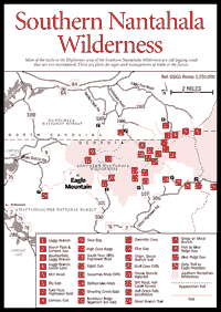
On the northern approach there is a wealth of logging roads by which one can hike up to the edge of boulderfields in both Loggy Branch and Giesky Creek watersheds. The western approach up Sim's Branch passes east of the prominent Bell Knob, with its landmark quartz mine on top, visible for miles around. Of the eight access approaches, six are through private lands whose owners have been friendly to hikers and campers (though not necessarily to hunters), providing they are courteous and considerate. If possible ask permission. Both the Scataway and Shoal Branch accesses, unlike Hall Creek access, have a buffer area of Forest Service land before the wilderness boundary. Accordingly, both parking and camping areas are provided. These latter two accesses are recommended for the average visitor.
This area is not well known, and the old settler trails across Skut and Lemons gaps are hard to find, but sometimes that is half the fun. There is little evidence of logging roads above 4,000 feet in the zone of northern hardwoods.
Plans for the management of the Southern Nantahala Wilderness are in process and will include signs and trails. The trails throughout the area are largely old logging roads, currently unmaintained and unmarked, and are for the intrepid explorer only.
The easiest approach to Hightower Bald is the Loggy Branch access [Fig. 31(1)]. How far to drive on these rough roads will be a matter of personal judgment. A jeep road turns and goes south up the hillside west of Loggy Branch, swings right, and passes by an enormous red maple at the foot of a large boulderfield [Fig. 31(3)]. The road then extends to Loggy Branch [Fig. 31(4)] a short distance below the wilderness boundary. If so inclined, one can locate the famous Montgomery Corner and/or 30-mile post where the state line takes a large jog north and south.
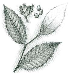
Loggy Branch Cove itself is a botanical paradise. According to Georgia's eminent botanist Wilbur Duncan, it compares favorably with anything in the Smokies. Up and down Loggy Branch, one can find the black, twisted trunks of the rare yellowwood tree. This is Georgia's largest colony, and one of the largest aggregations of yellowwood in the Blue Ridge. Most of this area is privately owned.
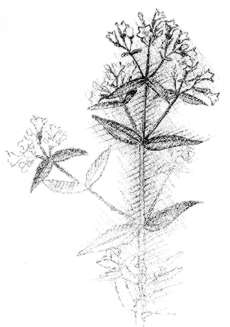
Higher up in the cove, one encounters a northern hardwood forest of beech, sugar maple, and yellow birch. In and below mountain gaps, visitors find the southern limit of the "Beech Gap" phase of this community, where high altitude varieties of beech predominate. On the cold, high side of Hightower [Fig. 31(7)] just under the top, there is a refuge for two plants normally associated with the spruce-fir forest: a beautiful viburnum and a type of oxalis clover. This is the only place in Georgia where this particular viburnum (Viburnum alnifolium) is known to grow.
The 150-foot cliffs on the south side [Fig. 31(11)] are dominated by moss and lichen, primitive rock spike moss, the rare Blue Ridge St. John's wort, and the federally listed and very rare Biltmore sedge. The boreal red-back vole, another Pleistocene relict, has been found here. On top is a dwarfed oak forest of white and red oak with a remarkably extensive growth of beaked hazelnut, which, with mountain raspberry, dominates the understory. Large hawthorn trees grow here and there. One can climb a dwarfed oak, as if walking up a ladder, and obtain fine views.
The ridgeline is supported by massive gneiss and amphibolite. A walk west down the ridge to Tom's Gap is rewarding; after a climb up a little cliff just west of Tom's Gap, one gets excellent vistas of the Hightower cliffs and the watershed below. Dwarf willow grows here in abundance on the cliff edge, and purple rhododendron is common.
The most difficult section of the ridgeline is between Shooting Creek Bald (4,317 feet) [Fig. 31(15)] and along the High Cove Ridge [Fig. 31(10)], an almost continuous series of rock outcrops, cliffs, and rhododendron. One can walk around under the cliffs; bear hunters prefer to burrow along the top. There is extensive rhododendron on the north face of Rattlesnake Knob. Otherwise the ridge is a fairly easy walk all the way to Eagle Mountain. Oak ridge forests to the east of Skut Gap [Fig. 31(9)] are dominated by northern red oak; those west are dominated by white oak. Just south of Egypt Gap [Fig. 31(12)], a series of small cliffs is covered with marginal wood fern, alum root, rock cap fern, and, nearby, monkshood.
The Sassafras Knob Cliffs [Fig. 31(13)] have bush honeysuckle. The coves, especially lower Owensby Cove and Loggy Branch [Fig. 31(4,17)], often have beautiful open stands of poplar or oak-hickory slope forest, waterfalls, and wildflower assemblages.
 Much
is to be learned from this relatively unexplored area. Early settlers lived
remarkably high and far back in the mountain coves. On the Loggy Branch Road,
a family named Davenport lived on rocky soil at about 3,000 feet. It is said
that sled loads of mayapple, used for medicinal purposes, came out of Loggy
Branch Cove and were sold for $.02 a pound. There are reported Indian petroglyphs
on a rock on the trail to Lemons Gap [Fig.
31(8)].
Much
is to be learned from this relatively unexplored area. Early settlers lived
remarkably high and far back in the mountain coves. On the Loggy Branch Road,
a family named Davenport lived on rocky soil at about 3,000 feet. It is said
that sled loads of mayapple, used for medicinal purposes, came out of Loggy
Branch Cove and were sold for $.02 a pound. There are reported Indian petroglyphs
on a rock on the trail to Lemons Gap [Fig.
31(8)].
LOGGY BRANCH COVE ACCESS. Northern access to Loggy Branch Cove, Hightower Bald, and the eastern part of the wilderness. On old US 64 east, pass Bethabara Road .4 mile; turn right at a sign on paved Eagle Fork Creek Road; go 2.1 miles to the third bridge; turn left on a dirt road just before the bridge. At .4 mile a gated road turns left. (This is a very rough jeep road. If chosen, take all other right turns and eventually reach Bly Gap on the Appalachian Trail.)
Past this gated road go about 2 miles from the paved road and follow the most developed road (through some private lands) to reach a U.S. Forest Service sign. Do not cross the branch but turn up the ridge following an old logging road which goes by a huge red maple and on to Loggy Branch [Fig. 31(1)], well up in the cove. Whether four-wheel drive is needed will depend on logging activities and rain. Certainly past the government boundary one will need four-wheel drive, but at that point the short distance to the lower cove [Fig. 31(4)] can be hiked.
NORTHERN ACCESS. To Beech Flats, Lemons Gap, and the central part of the wilderness. From GA 75 north out of Hiawassee, dead-end at old US 64; turn east and go 4 miles; turn south at the sign for Bethabara Road (1166); go 2 miles; take the last road (dirt) to the right (west) just before the bridge; go about .4 mile through an apple orchard; turn left; ford a creek and park. Continue south about .6 mile to where the road is blocked at a branch.
Walk up the road on the left side of the branch. The wilderness boundary is very close. Climb southeast through Beech Flats until coming to the ridgeline where, with luck, one will be in the vicinity of Rattlesnake Knob [Fig. 31(14)]. To dodge difficult cliffs [Fig. 31(11)] of High Cove Ridge, avoid striking the ridge east of Lemons Gap. An old trail to, or close to, Skut Gap [Fig. 31(9)] leaves the entrance road (turns south) just past the last house after the creek ford.
OLD SKUT GAP TRAIL. Northern access to Old Skut Gap Trail and the western part of the wilderness. From the junction of GA 75 north, turn east on old US 64; go 3.2 miles to the Giesky Creek sign (NC 1165); turn right (south); at 2.4 miles, in a U-shaped curve, cross the bridge over Nattie Branch. The landowner here, John Robbins, lives just north of the bridge and says to park on the west side of the branch where the old log road follows the route of the old trail to Skut Gap by way of Burnt Cabin Cove.
EAGLE MOUNTAIN ACCESS. The western end of the wilderness. Off GA 75 north of Hiawasee, turn east on Upper Bell Creek Road (Road 9) just before a bridge crosses and arm of Lake Chatuge; go 1.1 miles; turn right (south) on Bell Gap Road. At about 0.2mi, road bears right and becomes Morgan's Way; pavement ends at 0.6 miles; continue on well maintained dirt road 0.7 miles to parking area. From gate [Fig. 28(18)] hike up the log road to just before Ben Gap (1.7mi); turn left on horse trail and continue slightly downhill on log road for 0.4 mi before climbing again; at 2.6mi, turn sharp right to begin ascent up several long switchbacks, reaching Eagle Mountain summit at 4.25 miles from the parking area. There are frequent, reliable springs along switchbacks all the way to the summit.
SCATAWAY CREEK ACCESS. Southern entrance to the wilderness. Go north on GA 17/75 from Helen; turn right on US 76 and go 3.2 miles; turn north on a paved road (GA 100). At 1.2 miles, a paved road (GA 101) to the left goes up Jack Hooper Branch. It is possible to hike up to Eagle Mountain [Fig. 31] by this route, but there is no trail over the last mile of very steep terrain. The right fork (GA 100) continues toward the southern access trail to Skut Gap. After leaving the pavement, park and hike up an old log road trail [Fig. 31(22)] which does not follow the creek, but in .5 mile turns east up the slope and enters a clear-cut. Instead of turning east, head steeply uphill (north) through a small stand of pine trees, coming to an old road. This road climbs steeply, rounds the end of a ridge and joins a more open road. Approximately 1.2 miles from the U.S. Forest Service boundary, a trail turns right and goes southeast to the top of Bluff Cove Cliffs [Fig. 31(20)]. The old trail to Skut Gap [Fig. 31(9)] continues but is extremely hard to follow.
HALL CREEK ACCESS. This is the southern entrance to the central ridge of the wilderness and to the Maney Branch (Maney Cove) and Shook Branch (Owensby Cove) watersheds. It is the shortest route to the easternmost crossing of the main ridge by the old settlers' trail through Lemons Gap. A slightly longer hike is via the Shoal Branch access.
On the west side of the US 76 bridge over Hightower Creek, turn north on Upper Hightower Road. Take the first paved left, at 1.4 miles. The pavement ends in another .8 mile. After passing a flood-control reservoir on the right, be prepared to park along the gravel road anywhere south of the first mailbox on the left before reaching signs (another .2 mile) indicating private land, the Hall Creek Falls Wilderness community [Fig. 31(23)]. The public road ends a little south of these signs; walk up about 3,700 feet of graveled private road. Do not leave the road; it is a public right-of-way. After fording the creek twice, take the first old dirt road to the left [Fig. 31(22)], which leads to the red-blazed wilderness boundary. Follow the old road up the east side of the creek, Maney Branch. In less than 1,000 feet, watch for an old road or trail to turn eastward, sharply up a ridge [Fig. 31(24)]. This is the Shook Branch Trail. After about 1.25 miles on Shook Branch [Fig. 31(21)], Hall Branch Falls lies due east about 600 feet and barely within the wilderness boundary. About 1 mile up the Shook Branch Trail, Eller Gap Trail [Fig. 31(18)] intersects from the east. The "trail" up Owensby Cove [Fig. 31(17)] to Lemons Gap may be indistinct. Most trails in this area are currently unmaintained and unmarked. It is about 3,500 feet from the junction with the Eller Gap Trail to Lemons Gap, just east of Rattlesnake Knob [Fig. 31(14)].
 SOUTHERN
AND EASTERN ACCESSES. To go up Shoal Creek, continue east on the main Upper
Hightower Road (GA 105, blacktop). At about 2 miles, past the Hall Branch Road,
turn left on the narrow, paved Jack Branch Road. After crossing Hightower Creek,
continue past the first house on the left, then turn abruptly left onto a dirt
road that goes around and behind the house. This road is a public access to
Shoal Branch. It passes through its narrow, scenic gorge [Fig.
31(25)], then by a flood control reservoir and through a meadow. At the
meadow's end, enter the Forest Service boundary where parking and camping is
permitted.
SOUTHERN
AND EASTERN ACCESSES. To go up Shoal Creek, continue east on the main Upper
Hightower Road (GA 105, blacktop). At about 2 miles, past the Hall Branch Road,
turn left on the narrow, paved Jack Branch Road. After crossing Hightower Creek,
continue past the first house on the left, then turn abruptly left onto a dirt
road that goes around and behind the house. This road is a public access to
Shoal Branch. It passes through its narrow, scenic gorge [Fig.
31(25)], then by a flood control reservoir and through a meadow. At the
meadow's end, enter the Forest Service boundary where parking and camping is
permitted.
The Shoal Branch trail [Fig. 31(24)] continues northward 2,000 feet before swinging west to cross the creek and continue through Eller Gap [Fig. 31(18)] to intersect the Shook Branch Trail in Owensby Cove. For those who wish to climb to Hightower Bald, it is easy but steep bushwhacking due north from where the Shoal Branch trail turns west and crosses the creek. Upon encountering the base of the cliffs [Fig. 31(11)], turn left and work around to Tom Gap; then follow the ridgeline to the top or turn right and proceed until reaching Buckhorn Ridge [Fig. 31(16)]. Follow it to the summit. If the Buckhorn Ridge route is chosen, it may be necessary to crawl through heath thickets the last 100 yards or so before breaking out into the dwarfed "orchard" oak community on top.
A route with far less climbing but more walking is the eastern approach to Hightower Bald [Fig. 31(11)] via the Appalachian Trail. Past the Shoal Branch Road turnoff, the main road becomes gravel. About 2,000 feet beyond the Shoal Branch Road, bear right at a fork; go 1.2 miles to reach Blue Ridge Gap [Fig. 31(27)] (four-wheel drive recommended). At either Rich Knob [Fig. 31(5)] or Bly Gap [Fig. 31(6)], pick up the main ridge west to Hightower Bald.
Map References: USGS 1:24,000 series: Shooting Creek–Macedonia–Rainbow Springs–Hightower Bald.
Read and add comments about this page