 Tides,
Currents, and Waves
Tides,
Currents, and Waves 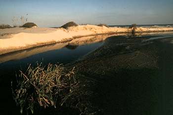
The Georgia coast has a moderate climate, with subtropical temperatures. During summer, a high pressure system called the Bermuda high settles in the Southeast and with its clockwise-rotating winds deflects most fronts moving across the area from the west. This produces occasional droughts.
Where the sea meets land at the coastline, daily temperature changes result in predictable ocean breezes. The sea maintains a more constant temperature, while landmasses heat up and cool down between day and night. During the day, the air above the land heats and rises, which draws wind toward land from the sea. At night, the land cools, and wind is drawn toward the warmer sea.
This cycle produces convection storms during the summer. As the sun rises, it heats the land, which heats the air above it, and as heated air rises, it draws in cooler, moisture-laden air from the coast. This air heats and rises as well, creating storm clouds as it rises and condenses. By noon, a thunderhead may have been created and by the afternoon, the coast may be drenched by a short-lived rainstorm, depositing the moisture back on the coast.
Occasionally, the Georgia coast is walloped by a hurricane. Hurricanes can be devastating, with winds up to 200 miles an hour, spawning deadly tornadoes and floods. On average, 1.6 hurricanes make landfall each year in the U.S. The Georgia coast has a 5 percent risk of being hit by a hurricane annually, with August, September, and October being the most common months for the storms. The origin of hurricanes is not entirely clear, but they are formed in tropical oceans when there is a large body of warm, moist air that develops into a counterclockwise-rotating storm with winds over 74 miles per hour.
Because of its geographic position, Georgia is one of the safest-rated areas on the Atlantic and Gulf coasts. But that doesn't mean don't worry if there's a hurricane warning. The Georgia coast experienced five major hurricanes in the 1800s, including one that put Tybee Island completely under water, but has been mostly spared in the 1900s. Hurricane Hugo was headed for Tybee in 1989, but veered north to Charleston, South Carolina, where it killed 86 people and did $7 billion worth of damage. Hurricane Andrew in 1992 hit Miami and killed 61 people, destroyed $26.5 billion worth of property, and made 160,000 people homeless. The most deadly hurricane of the 1900s landed in Galveston, Texas, in 1900 and killed 8,000 people.
These seasonal storms, first recognized by Benjamin Franklin, merit significant mention because of the erosion they cause on the Georgia coast. Occurring every fall to spring, nor'easters feature strong frontal winds created by a low-pressure cell that accompanies cold fronts that sweep through the area. Nor'easter winds swirl in a counter-clockwise fashion, with steady winds blowing from the northeast at 25 miles an hour, which can continue for several days. The wind pushes tides higher, makes the surf and longshore currents rougher and stronger, and blows a lot of sand. A long season of strong nor'easters can lead to significant erosion.
Tides,
Currents, and Waves Tides are the effect of the gravitational pull of the moon and sun. Currents are the effect of tides, wind, rain, rivers, evaporation, and ocean topography. Waves are created by open ocean winds. Combined, they are an overpowering and defining force on all coasts, and on the Georgia shore, life is defined and dependent on them.
The moon's gravity pulls a bulge of water toward it. On the opposite side of Earth, another bulge is created due to centrifugal forces from the earth's rotation. As the water is stretched into an oblong, the sea between these two opposite bulges is lessened in volume, creating low, or ebb tides. As the moon circles the earth every 24 hours and 50 minutes, the water bulge follows it, creating a high tide on the shoreline below the moon. With every complete orbit around a specific piece of landscape, there is a different tide every quarter of the cycle, or every 6 hours and 12.5 minutes. First a high or flood tide (the bulge below the moon), then 6 hours and 12.5 minutes later a low tide, then 6 hours and 12.5 minutes later the second high tide (the bulge opposite the moon), then 6 hours and 12.5 minutes later the second low tide, and 6 hours and 12.5 minutes later the high tide again that completes the cycle. Because it takes the moon 24 hours and 50 minutes to cycle around the earth, tides are 50 minutes later each day.
The sun also has a gravitational pull, but being much farther away, it only has roughly half the effect. When the sun and moon are in the alignment called syzygy (when the moon is directly between the earth and sun, indicated by a new moon, or is directly behind the earth, indicated by a full moon), gravitational forces are combined to create the highest and lowest tides on earth called spring tides. Neap tides occur when the moon, earth, and sun create a 45-degree angle to each other, indicated by a quarter moon phase, which has a canceling effect that produces small differences between high and low tides. Two spring tides and two neap tides occur every month.
The degree of sea level change between high and low tides is greatly affected by the slope and shape of underwater geography. The world's biggest tides are in the Bay of Fundy, located between New Brunswick and Nova Scotia, which rises 45 feet, while Lake Superior only has a tide of 2 inches. Every 24 hours, the Atlantic coast has two high tides and low tides, the Gulf of Mexico coast has one high tide and low tide, and the Pacific coast has two high and low tides of mixed heights.
 The
Georgia coast is the most western coastline on the Atlantic seaboard, putting
Georgia at the center of a giant funnel called the Georgia bight. At high tide,
water is pushed by the shape of the coastline from North Carolina and Florida,
forcing water to gather on top of itself, creating a 6- to 8-foot tidal change
on the Georgia coast at the center of the funnel. The sides of the funnel on
the central Florida and North Carolina coasts have 3-foot tides.
The
Georgia coast is the most western coastline on the Atlantic seaboard, putting
Georgia at the center of a giant funnel called the Georgia bight. At high tide,
water is pushed by the shape of the coastline from North Carolina and Florida,
forcing water to gather on top of itself, creating a 6- to 8-foot tidal change
on the Georgia coast at the center of the funnel. The sides of the funnel on
the central Florida and North Carolina coasts have 3-foot tides.
On some coasts, like North Carolina, the dominant force is wave energy. On the Georgia coast, the dominant natural force is the tide. Like a heart pumping blood through the body's vital organs, Georgia's tides pump a tremendous volume of water in and around the barrier island, into the sounds (the area between barrier islands), and the marshlands. Life has adapted to and become dependent on this natural process in ways great and small. Without the pulsing of tides, Georgia's Spartina marshes would disappear. When tides are high, mollusks like clams and oysters open and feed. When tides drop and expose the bivalves, they close and retain sea water inside their shells, waiting for the next tide to come. Juvenile fish and other life feed on the nutrients circulated through the marsh and estuary by tides. The tides carry dead Spartina out of the estuary on outgoing tides, then deposit the stalks on beaches during high tides. The Spartina traps blowing sands and becomes the foundation of dunes, laying the groundwork for other plants to come. When tides are low, many birds and mammals know food sources are more exposed in the intertidal zone and come to the beaches and mud flats to feed.
To humans, knowledge of the tides can be an asset. When Julius Caesar attacked the English coast in 54 b.c. during a full moon (which creates the greatest tidal range), he was unaware of the 20-foot tide, which stranded his fleet, then destroyed it when the tides changed. Closer to home, beach lovers have drowned on the Georgia coast when they have been stranded on sandbars and underestimated the strength, direction, and duration of tidal forces. Tidewater plantations harnessed the power of tides for growing rice, and sawmills in Darien used the action of tides to power machinery.
The Georgia shore is greatly affected by tidal currents pulsing in and out of sounds and longshore currents running north to south and close to barrier islands. Having a much smaller effect on the Georgia coast is the Gulf Stream, which is located 80 to 120 miles offshore and flows south to north.
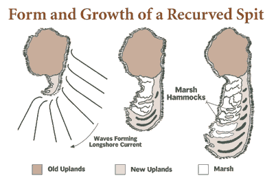
Because of tides, longshore currents, waves, and winds, barrier islands in Georgia tend to be shaped like a turkey drumstick with a bulbous northern end and narrower southern end. Fast-running tidal currents, which flow in and out of sounds found between barrier islands, carry nutrients and sediments from marshes and rivers. When they reach the longshore current, they are deflected south and drop much of their sediment load. Here sandbars or shoals can build up to become barrier islands.
Wave energy on the Georgia coast is relatively low, because of the long distance waves must travel over the Continental shelf before reaching the shoreline. Waves are created by open ocean winds and may travel hundreds of miles. Waves break when water on top of the wave moves faster than water on the bottom of the wave, which is generally caused by the bottom of the wave dragging or tripping on underwater shoals, causing the peak to topple over.
At the coast, fresh water from rivers and precipitation runoff mixes with salty sea water to create the estuarine ecosystem. Sea water averages 3.5 percent salt, or roughly one teaspoon of table salt in a glass of fresh water. When we taste the salt of our tears, sweat, or blood, we are being reminded of our origins. In our bodies the salt content is 0.9 percent, but the elements sodium, potassium, and calcium are combined in almost the same proportions as in sea water, an inheritance from remote ancestors from millions and millions of years ago when the first primitive circulatory systems consisted of sea water.
If our systems were as salty as the ocean, we would be able to drink sea water. But, when we drink salt water we are actually dehydrating ourselves because of a process called osmosis. Living cells must be wet to function and all life processes occur in water solutions or mixtures. Osmosis is the physical process in which a living cell tries to balance the concentration of minerals on either side of a membrane. Water passes through a membrane from the less to the more concentrated solution in an attempt to make concentrations equal. So when one drinks sea water, fresh water is absorbed by the sea water due to osmosis, dehydrating the parched drinker. This fact of life has a dominating effect on the plants of the salt marsh. The concentration of salts in most plants is lower than salt water, so when most plants are immersed in sea water, they lose fresh water through their membranes, which kills the cells. So only plants that have developed strategies for dealing with salt water can survive in the salt marsh, such as smooth cordgrass (Spartina), needle rush, salt grass, glasswort, salt meadow cordgrass, and sea oxeye.
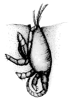
Fauna of the estuary and inshore waters must adapt to a brackish environment. The saline content of the water drops as one moves from the coastal waters (32 parts of salt per thousand parts [ppt] of water) up a river (less than 1 ppt). Generally, freshwater organisms do not descend far down a river estuary, but marine creatures, with different degrees of tolerance, can penetrate far upstream. Oysters can tolerate less than 5 ppt, but their predator the oyster drill can tolerate no less than 9 ppt, resulting in an oyster "line" that marks a safe zone for oysters.
The degree of salinity in a particular zone of the coast plays a role in the chemistry of the sea, affecting the natural cycles of elements that provide the foundation of life for sea creatures. From sea water, marine animals extract mineral salts and use them in many ways. Mollusks and crustaceans extract calcium from the water for their shells and skeletons.
Read and add comments about this page