 Lewis
Island Natural Area
Lewis
Island Natural Area This 137-mile alluvial river is one of the great natural treasures of the eastern United States, flowing undammed from its creation at the confluence of the Oconee and Ocmulgee rivers near Hazlehurst to the multichannel river delta near Darien. Crossed by roads only five times, the largely undisturbed river is believed to be more than 20 million years old, and pumps an average of 100,000 gallons of fresh water into the sea every second, making it Georgia's mightiest river. As impressive as the river's volume is—comparable to the Nile—even more significant are the 170,000 acres of magnificent river swamps that insulate the river almost the entire length of its course. The river, swamps, and sand ridges serve as refuge to at least 130 species of rare or endangered plants and animals, including seven species of freshwater mussels found nowhere else in the world; Radford dicerandra, a rare species of mint; and the only known Georgia population of Florida corkwood.
The Altamaha River is popular with naturalists and bird watchers for its flora and fauna, and with anglers who pursue its abundant game fish. A watercraft is necessary to experience the Altamaha at its greatest glory. The bird lover will find waterfowl, wading birds, owls, woodpeckers, raptors, and songbirds to be common residents and migrants of the river's swamps, bottomland hardwoods, oxbow lakes, and marshlands. Endangered species such as bald eagles and swallowtail kites soar above its banks. Reptiles such as alligators and a variety of snakes and turtles find refuge by the river, as do white-tailed deer, mink, otter, raccoons, rabbits, opossums, and armadillos. Endangered West Indian manatees have been seen swimming as far upsteam as Fort Barrington, and shortnosed sturgeon use the waters as nursery grounds. Botanical oddities attract naturalists, who know the legend of the Franklinia alatamaha, a flowering tree that was identified and collected near the river by eighteenth century naturalist William Bartram and never seen again (see Fort Barrington/Barrington Park). Some believe the tree may still survive somewhere in the wild near the river. Not only does the river possibly hide the world's rarest tree, it likely has the oldest trees this side of the Mississippi River. On Lewis Island, a 300-acre tract of virgin cypress contains ancient giants, including one that is believed to be 1,300 years old. Depending on their location on the river, fishermen try their skills for catfish, sunfish, crappie, bluegill, and bass upstream, and shad, mullet, striped bass, tarpon, and shark downstream (see Two-Way Fish Camp).
This river and its swamps are more important than just the variety of species found in them. They play a vital role in supporting the rich estuary located downstream. During times of low water, the river swamps accumulate organic matter in the form of leaves, twigs, and other detritus. During spring floods, high water picks up detritus and other small creatures in the woods and washes them into the main river, which carries this "natural fertilizer" downstream. The nutrients are trapped and used in the marsh, a belt of salt-tolerant grasses in a band 4 to 6 miles wide between Georgia's mainland and barrier islands. The marsh grasses incorporate the natural fertilizer into their stems and roots, and as the grass dies and disintegrates, it is consumed by decomposers of the estuary such as bacteria and fungi, which help phytoplankton and benthic algae. These are in turn eaten by primary consumers such copepods, mud worms and snails, shrimp, crabs, and oysters, which in turn support secondary and tertiary consumers including fish, birds, and mammals. The marshes release their nutrients gradually, creating one of the most productive ecosystems in the world. Without these marshes, the nutrients would be washed out to sea in one big pulse each year.
The big river also carries a tremendous sediment load, adding additional nutrients to the mix in river swamp and estuarine ecosystems and creating barrier islands. Without the river, it is believed, there would be no St. Simons Island. Little St. Simons Island continues to grow at a tremendous rate from sand washed down the Altamaha River.
The 14,500-square-mile Altamaha River basin is the second-largest watershed on the Eastern seaboard. The watershed drains more than a quarter of the state, with its northernmost headwaters in the Piedmont province 10 miles northeast of Gainesville in Hall County, Georgia. Small creeks run off the Chattahoochee Ridge, a spinelike geological feature that runs northeast to southwest and forces water westward and the Chattahoochee River and the Gulf of Mexico or to the east and the Oconee and Ocmulgee rivers, which meet near Hazlehurst to form the Altamaha. The river at Doctortown Landing near Jesup is a broad, meandering stream, surrounded by cypress, gum, and willow swamps. Set back up to 2 miles from the main channel are ancient bends of the river, isolated by time into curved, oxbow lakes with names like Whaley, Morgan, and Johnson, which serve as important spawning grounds for fish and freshwater sources for reptiles and birds. (The world's record largemouth bass was caught in an oxbow lake of the Ocmulgee River in Telfair County, part of the Altamaha River basin.) As the river's wanderings cut into the sand ridges that parallel the river, the higher and drier woodlands support bay trees and magnificent moss-draped oaks. Pine plantations, managed by pulp and paper companies, are planted adjacent to the river swamps.
Below Lewis Island, the river forks into different winding channels, and the river becomes affected by the twice-daily tides. The vegetation on the riverbanks changes into grasses and reeds, and behind these banks are the remnants of antebellum rice plantations, such as Butler and Hofwyl-Broadfield. Butler Island Plantation is where Fanny Kemble Butler wrote the powerful abolitionist book Journal of a Residence on a Georgian Plantation that was influential in keeping England from entering the Civil War in support of Confederates. Today, Butler Island is the Altamaha Waterfowl Management Area and Hofwyl-Broadfield is a state historic site. The river meets the sea in four channels, from north to south: the Darien, Butler, Champney, and South Altamaha rivers.
The name Altamaha, pronounced All´-ta-mahaw´, is from an immigrant Yamassee Indian group descended from an interior chiefdom originally known as Altamaha or Tama, located on the Oconee River just below Milledgeville, visited by Hernando de Soto in 1540. The Altamaha chiefdom was forced into slavery, but rebelled and eventually settled in St. Augustine until it evacuated with the Spanish to Cuba in 1763. The Spanish referred to it during the 1600s as Rio de Santa Isabel, referring to an early mission called Santa Isabel de Utinahica, established in the Timucuan chiefdom of Utinahica located at the forks of the river near present-day Lumber City. The ruins of more than 1,000 Indian sites along the river are evidence of how important the river was to Indians, who relied on it for food and transportation.
The river has seen not only the dugout canoe, but also Spanish galleons, huge rafts of cotton and timber, and paddlewheel steamboats. Today, most watercraft are motor-powered bass boats that belong to sport fishermen. Hernando De Soto wrote about the river in 1539, and so did early naturalists who were fascinated by the New World flora and fauna found at "Georgia's Little Amazon." Fort Barrington witnessed military activity during the American Revolution, the War of 1812, and the Civil War. At Morgan's Lake, the Blue and the Gray faced off in a minor historic episode of Sherman's March to the Sea during the Civil War.
Protecting the river and its swamps, from The Forks to the place where the river meets the sea, has been a goal of many organizations since the late 1960s. Today most of the river is under some form of legal protection in a patchwork of various tracts. In 1969, Wolf and Egg islands at the mouth of the river became a national wildlife refuge. In 1972, the state acquired the 6,177-acre Big Hammock Natural Area and the 5,633-acre Lewis Island Natural Area. Big Hammock, located on the northern bank of the Altamaha near Glennville, consists mainly of bottomland hardwoods and sloughs, and an 800-acre sandhill community that supports the largest population of the Georgia plume (Elliottia racemosa). Lewis Island Natural Area contains virgin cypress tidewater forest, with Georgia's oldest trees. In 1974, the 1,268-acre tidewater rice plantation Hofwyl-Broadfield was preserved, and in 1978, the 1,331-acre Altamaha River Natural Area was created when ITT-Rayonier donated the tract to the State of Georgia, which includes a border of land extending 300 feet from the riverbanks in Long, Wayne, and McIntosh counties. Other protected tracts near Darien include the 752-acre Cathead Creek Preserve; the 6,259-acre Buffalo Swamp; and the 27,078-acre Altamaha Wildlife Management Area (or the Altamaha River Waterfowl Area), which includes Lewis, Cambers, Wrights, Butler, Champney, Broughton, Rhetts, Rockdedundy, and Dolbow islands; and the 15,526-acre Sansavilla Wildlife Management Area.
[Fig. 3(4)] Barrington County Park provides access to the river and a beautiful setting for picnicking, camping, or fishing on the Altamaha River near a historic colonial fort. Fort Barrington was built on a sand ridge in McIntosh County to control the best place to cross the broad Altamaha River in its southern section, a shallow ford north of where the river divides into four channels. In pre-Columbian times, Indians crossed the river here on their ancient overland trail between Savannah and St. Augustine, which in 1736 became Gen. James Oglethorpe's Post Road, traveled by Methodist minister John Wesley and Scottish Highlanders in their march on Fort Frederica.
The natural settings are a mix of sand ridges, river swamp, bay forest, and pine flatwoods. The sand hills are composed of nutrient- and moisture-poor soils, which support hardy flora such as turkey oak and longleaf pine, along with post and bluejack oaks and mockernut hickory. On lower areas southwest of the road are baldcypress and tupelo. On drier floodlands are bay forests consisting of sweetbay magnolia, loblolly bay, and red bay, and at higher elevations are pines such as slash and loblolly. Deer and feral hogs are common game animals seen near the property.
Near here on October 1, 1765, naturalists John and William Bartram found the legendary Franklinia alatamaha, a beautiful, 15-foot flowering tree that is a kind of holy grail for botanists. The Bartrams, thankfully, collected seeds from the unusual plant that was later successfully propagated. Today, all living Franklinias are descended from these seeds, and the plant is believed to be extinct in the wild. Eight years later, William Bartram returned without his father and rediscovered the plant, this time in bloom, and wrote about it in The Travels of William Bartram. In the Naturalist's Edition of Bartram's Travels (1958), Francis Harper writes that he believes the actual location of the tree to be on "a sand-hill bog on the north side of the (Fort Barrington) road at a point about 1.7 miles northwest of Cox."
The colonists of Darien worried about being attacked from the rear by the Spanish, French, and hostile Indians. In 1761, a square structure with 75-foot-long walls was built to stand guard at the river crossing. Called Fort Barrington in honor of a friend of Oglethorpe's, it was garrisoned by 25 rangers. During Revolutionary times, it was called Fort Howe. The fort was abandoned after being garrisoned during the Civil War. A ferry operated here from colonial times until the early 1900s, when railroads, roads, and bridges put it out of service.
Today, time has claimed the wooden fort, and the river has eroded half the earthworks. A hunting club owns the remaining earthworks, and unfortunately a private boat ramp runs down the middle of the fort. Nearby, Barrington County Park is open to the general public for boat launches, tent or RV camping, or a quiet picnic. Bathrooms and trash cans are found at the site.
Canoeing the Altamaha River, in the main channel, is not the most intimate experience found on Georgia's smaller rivers, neither is it the most exciting whitewater trip. However, the Altamaha is the largest virtually unspoiled river in the Southeast, with beautiful river swamps bordering it along its entire length. In higher waters, canoeists can thread into river swamps for a true wilderness experience, and its upper reaches provide unforgettable canoe camping on its sandy banks.
Caution is urged. Access to the river is limited. If one got in trouble, it would be a difficult feat indeed to try to walk out through (for example) Penholoway Swamp with a broken arm. So the key here is planning. Visit your takeout site so you have a better chance of recognizing it from the water. The river swamps and multiple channels of the river can get confusing in a hurry so take good maps and know how to use your compass. Learn the landmarks or signs that mark your journey. In the lower reaches, the river widens to 1,200 feet in some places and the canoeist faces twice-daily tides and confusing marsh deltas. Strong currents and unexpected bad weather here can swamp your canoe in a hurry and wash you out to sea with the outgoing tides. Be very careful so your trip is a safe one.
Doctortown to Paradise Park, 19.6 miles. This trip takes the canoeist through The Narrows, perhaps the most scenic section of the entire river. Doctortown is located on the western bank of Wayne County near Jesup where US 301 crosses the river below river mile marker 65. Signs on US 301 direct you to the site. Paradise Park is accessed on the western side of the river, where Penholoway River enters the Altamaha after mile marker 46. The park is 1 mile upstream on the Penholoway, and is reached with care from Gardi by traveling east on River Road roughly 5 miles, then left for 1 mile to Paradise Park.
Paradise Park to Altamaha Park, 17.2 miles. This stretch of the trip takes the canoeist past Barrington Park on the eastern bank of the river (a good place to camp if you are looking for company) and into tidally influenced waters, finishing at Altamaha Park on the western bank. Altamaha Regional Park is located on Altamaha Park Road east of Everett on US 341 in Glynn County. Here, boats and campsites can be rented (see camping in Glynn County). (912) 264-(912) 2342. Birders may want to turn right onto Pennick Road from Altamaha Park Road to visit the Atkinson Tract, which is a cut-over, swampy area that parallels the river. Here near Cowpen and Clayhole swamps, you may see nesting indigo and painted buntings, vireos, hooded warblers, summer tanagers, and yellow-breasted chats. See Fort Barrington/Barrington County Park for directions to Barrington Park.
Altamaha Park to Darien City Dock, 13.7 miles. This last trip should be undertaken only with knowledge of current landmarks and daily tides. The canoeist travels 10.5 miles on the Altamaha River, taking the northern (left) channel, then negotiates narrow Rifle Cut 1.5 miles to Darien Creek for 1 mile. Then take the Darien River to the boat ramp for 0.7 mile. Lewis Island is a 2-mile detour on this trip by the way of Buzzard Creek. This adventure should not be undertaken without consulting local authorities concerning landmarks or blazes that mark the way to the ancient trees. Recall that the trees still remain because they were so hard to get to in the first place.
Paradise Park to Barrington Park, 11.8 miles; Paradise Park to Lower Sansavilla Landing, 9.5 miles (Lower Sansavilla Landing is found on Sansavilla Road east of Mt. Pleasant on US 341.); Lower Sansavilla to Altamaha Park, 7.7 miles.
[Fig. 16] The 27,078-acre Altamaha Wildlife Management Area/Altamaha River Waterfowl Area (ARWA) is the second largest waterfowl area east of the Mississippi (the largest being the Chesapeake), and is visited by more than 30,000 ducks from mid-October through mid-April. A stop on the Colonial Coast Birding Trail, the area is equally popular with naturalists, bird watchers, duck hunters, and fishermen.
The ARWA consists of several "islands" that are created by the Altamaha's meandering channels: Lewis, Cambers, Wrights, Butler, Champney, Broughton, Rhetts, Rockdedundy, and Dolbow islands. Lewis Island is a naturalist's wonderland, containing virgin cypress stands over 1,000 years old. Most of the other islands are dominated by a variety of marsh grasses that have flourished since antebellum times, when hundreds of slaves cleared the land of timber, dug canals, and built water-control dikes that were used to establish successful rice plantations.
Some of these canal-crossed islands, such as Butler and Champney, are former sites of plantations that today are important nesting and refuge sites managed for migratory waterfowl. Freshwater plants such as giant cutgrass, pickerelweed, wild rice, cattails, widgeon grass, and wild millet help support the duck population. Many species use the freshwater sites, including mallards, scaup, ring-necks, black ducks, pintails, canvasbacks, buffleheads, gadwalls, scaup, widgeons, mergansers, shovelers, green-winged teals, and occasionally the fulvous tree duck. A large population of snipe is found in January and February, and rails are also common in the marshes.
Mammals observed in the wildlife management area include deer, red and gray foxes, beavers, cottontail and marsh rabbits, feral hogs, otters, bobcats, minks, opossums, armadillos, raccoons, bats, and mice. In the tidal waters are dolphin and an occasional manatee. More than 26 species of snake have been reported here, including coral snakes, cottonmouths, copperheads, and pigmy and diamondback rattlesnakes.
Lewis
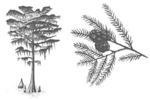
Island Natural Area [Fig. 16(1)] Without sandy beaches and high-rise condominiums, this is not what people generally imagine when you say "island." But Lewis Island, located five miles up the Altamaha River, is accessible only by boat and is a natural treasure that has fascinated scientists and naturalists alike. The 8-mile-long island contains a remnant of the great hardwood forests that bordered Georgia's Coastal Plain rivers, including the largest known grove of virgin tidewater cypress and tupelo gum trees in Georgia. One 300-acre stand of baldcypress has trees 6 to 7 feet in diameter, which are estimated to be 1,000 years old, with one tree believed to be over 1,300 years old.
The primitive island is defined on the west by the main channel of the Altamaha River and on the east by Lewis Creek and the broad, dense Buffalo Swamp. Loggers attempted to get to the trees, but thankfully logging cables were not long enough to reach them and today never will because the tract was purchased from the Georgia-Pacific Corporation by the State of Georgia in 1973 to be protected as part of the Altamaha State Wildlife Management Area.
The 5,633-acre natural area is home to deer, otters, raccoons, feral pigs, and gray squirrels. Swallow-tailed kites nest here, and also observed on the island are Mississippi kites, parula warblers, yellow-crowned night herons, green herons, Louisiana herons, pileated woodpeckers, egrets, ibis, and wrens. Snail-loving limkins have occasionally been seen near the island. Common reptiles are alligators, Florida cooters, yellow-bellied turtles, as well as rainbow, mud, cottonmouth, yellow rat, and red-bellied water snakes. Near the water's edge, streamside flowers such as the pink-flowered Physostegia are common, along with wild potato vine, spider lilies, and swamp mallow.
An interesting characteristic of Lewis Island is that it is a tidewater swamp, which means it has adapted to daily fluctuations in water levels and current flow, unlike river swamps that are affected mainly by seasonal fluctuations in water levels.
The island must be approached by boat. The floor of Lewis Island may be under water from January to June, when the river leaves its banks, submerging a half-mile trail leading to the big trees. When the river is down the rest of the year, the trail reappears, but be sure to take shoes that can get wet and muddy. The trailhead is located approximately 0.25 mile southeast of the intersection of Studhorse Creek and Pico Creek. The Department of Natural Resources attempts to keep the trail marked, but floods may remove or hide the blazes, so its best to ask for directions and river conditions at the area's headquarters on Butler Island.
[Fig. 16(2)] Butler Island and its southern neighbor Champney Island are readily accessible to the visitor without a boat and are good sites for bird-watching during waterfowl migrations. On Butler Island, the house and grounds are used as a private staff residence for the Altamaha Waterfowl Management Area and are not open for public tours. Tourists can view the property from US 17. An observation tower and marked trail on Champney Island provide easy access for wildlife viewing of the flat, marshy terrain. During the winter, the quiet observer may identify some of the refuge's known 18 species of ducks, including nesting wood ducks, and at other times discover numerous wading birds, including a variety of herons and egrets. Swallowtail kites and bald eagles are known to nest near the area, and alligators and a variety of snakes are common.
While migratory waterfowl benefit and depend on the flooded fields for food and rest, the islands did not always look like this. Butler Island was the site of one of the largest, most successful antebellum tidewater plantations in America. With the help of hundreds of slaves, Irish-born Major Pierce Butler created a grand rice and sugar plantation out of the cypress-and-marsh wilderness in the early 1800s.
The tidewater ecosystem was very suited to the production of rice. The high range of the twice-daily tides made it possible to flood the fields; the plantations' distance from the sea and volume of fresh water from the river protected crops from salt water; the rich alluvial soils deposited over thousands of years in the river delta were fertile for growing crops; and the availability of slave labor made the back-breaking work economical. The clay soils of the Altamaha delta are the richest in McIntosh County, according to soil surveys.
Today, the only signs of the enterprise are a 75-foot brick chimney that was a steam powered rice mill built in 1850 and the still-operational dike system, designed by engineers from Holland. Located on the property is the two-story home of Col. T.L. Huston, a half-owner of the New York Yankees, who had a Guernsey dairy farm and a successful truck farming operation that shipped iceberg lettuce grown in the restored fields. The residence was built in 1927. In the 1920s, many baseball players visited Huston, including Babe Ruth.
Butler arrived in the American colonies in 1771 as an officer in the British Army. Excited by the opportunities in the New World, Butler resigned from the Army, married an American woman who was a daughter of a rich Charleston plantation family, and started a long, successful career as a planter and politician. Butler was an ardent pro-slavery advocate, defending the peculiar institution at the Constitutional Convention of 1787, and helping to draft the fugitive slave law and the Three-Fifths Rule whereby a black slave was considered to be only three-fifths a person. Butler was a friend of George Washington, Benjamin Franklin, Thomas Jefferson, James Madison, James Monroe, Alexander Hamilton, and Aaron Burr. (Burr sought asylum at Butler's plantations after he killed Alexander Hamilton in a duel in 1804.) Butler was chosen by the South Carolina legislature to be the state's first U.S. senator.
Eventually, Butler obtained the 1,500-acre tidewater island that he named for himself, as well as property on the northwest end of St. Simons. Butler Island became a rice plantation and Hampton Plantation grew sea island cotton. Butler was an absentee owner, spending most of his time away on business in Charleston or Philadelphia, so he depended on his plantation manager and slave overseer Roswell King Sr. to keep the plantations operating successfully. Friction between Butler and King resulted in King being relieved of his duties after 18 years working the plantations. Connecticut-born Roswell King Sr., who was known for his cruelty to slaves, moved to an area north of Atlanta in 1837 where he established Roswell Manufacturing Company. (King died in 1844, and the town was eventually incorporated as Roswell in 1854.) Butler died in 1822, and the property eventually passed down to his grandsons after they agreed to the will's stipulation that they use their grandfather's last name.
In 1834, Pierce Butler II married the celebrated English actress Frances (Fanny) Anne Kemble, and had two children, Sarah and Frances. In 1838–1839, he brought his wife to his grandfather's plantations. During this period, Fanny Kemble wrote letters to a friend about her shock and disgust at the treatment and conditions of the plantations' slaves, which by then were under the control of Roswell King Jr. She never sent the letters, and left Butler in 1845 and returned to England. In 1848, Butler filed for divorce and the following year, in a sensational court case, a Pennsylvania court awarded the divorce and custody of both girls to Butler.
Though pressured by abolitionist friends to publish her journal, Kemble held off until her children had grown up and the Civil War had started. Her writings were published in 1863 under the title of Journal of a Residence on a Georgian Plantation in 1838-39 and have become one of the most famous antislavery treatises ever written. The descriptions of plantation life, slavery, Darien, and flora and fauna of the area make the well-written book fascinating reading. For example, we learn from Kemble that slaves were kept in four settlements on Butler Island, "consisting of from ten to twenty houses…[the slave] cabins consist of one room about 12 feet by 15…[where] two families (sometimes eight and ten in number) reside…"
During the Civil War, the property was abandoned. In 1866, Fanny's daughter Frances returned with her father in an attempt to restore the plantation's former glory. Frances, who adopted her father's proslavery views, also kept a diary, published in 1883, titled Ten Years on a Georgia Plantation, considered the best account of what it was like in Georgia during Reconstruction. Until the end, Frances remained loyal to her father, never doubting that blacks fared better under slavery than freedom, and she argues for the institution in her book. However, without slavery and in the postwar depression in the South, rice and cotton plantations were doomed, and the fifth generation of Butlers sold the remains of their lands in 1923.
Champney Island, also the site of a rice plantation, is today a 34-acre Ansley-Hodges Memorial MARSH Project built in 1989 and sponsored by Ducks Unlimited. An excellent observation tower a short walk away from the parking area gives bird watchers a perch to view waterfowl and wading birds in the freshwater marsh, including great and snowy egrets, least and American bitterns, and in the spring, black-necked stilts. Common migrating songbirds in the fall include the common yellowthroat, indigo bunting, and swamp sparrow. A 1-mile nature trail, with marked sites and brochures, explains the workings of the managed ecosystem. The road follows the perimeter of the island, looping up to Interstate 95 and back to US 17. Driving slowly on this road, or parking for short excursions, can be rewarding. Remember to bring your binoculars, bird book, and insect repellant for the most enjoyable visit.
 Wolf
Island National Wildlife Refuge
Wolf
Island National Wildlife Refuge [Fig. 16(7)] This three-island wildlife refuge in the mouth of the Altamaha River consists mainly of salt marsh and provides critical sanctuary for rare migrating birds. Bird-watching from the water and saltwater activities (fishing, crabbing, and shrimping) are permitted within the boundaries of the refuge, but access to the beach and upland areas is strictly prohibited. Unlike many national wildlife refuges, no hunting is permitted on the island.
Wolf Island, the largest island in the refuge, is defined by South River to the north, Little Mud River to the west, Altamaha Sound to the south, and the Atlantic Ocean to the east. The island consists of 4,519 acres, with only 300 acres of dune and beach along its narrow, 4-mile-long eastern shoreline. The island fronts the sea in the Altamaha River delta, and is a physical barrier between Doboy Sound to the north and Altamaha Sound to the south. The interior of the Holocene island, which is 97 percent Spartina alterniflora, is divided by many tidal creeks, including Wolf, Beacon, and Beach, where fishing is reputably excellent. Needlegrass, sea oxeye, and glasswort are also found in higher places in the marsh along with some small shrub hammocks, and salt flats cover the central marsh. Sea oats, sandspurs, smilax, and other beach-dune perennials flourish on Wolf Island's beach dunes, and higher ground supports scrub southern red cedar and wax myrtle.
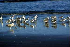
The undisturbed island provides a haven for migratory birds. Thousands of birds use the island in fall and spring migrations, including royal, Caspian, and Forster's common terns; semi-palmated and black-bellied plovers; least sandpipers, dunlins, sanderlings, and ruddy turnstones; and a variety of gulls. Black skimmers, oystercatchers, great blue herons, brown pelicans, and common egrets use the island year-round, as do clapper rails that nest in the marsh. Waterfowl are less frequent, but mergansers, scaups, and buffleheads are seen in the salt water bordering the island. The island also is an important nesting ground for endangered loggerhead sea turtles.
Tucked into the mouth of Altamaha Sound directly south of Wolf Island are Egg and Little Egg islands, the two other islands in the refuge. They comprise 593 and 14 acres, respectively, and support extensive salt marsh with only 70 acres of upland. Egg Island has some oak and pine trees and is used by migratory birds, and Little Egg Island has shielded colonies of royal terns, black skimmers, and laughing gulls. Nearby, Egg Island Bar, closed by the state to human use, supports the largest nesting colony of royal terns on the Atlantic coast, with more than 9,000 pairs. It serves as a rare nesting ground for black skimmers, gull-billed terns, and brown pelicans as well.
Wolf Island's recorded history is short compared with its larger island neighbors. The first owner was Christopher DeBrake, who was granted 150 acres of the island (the upland portion) on March 7, 1769 by King George III. Early diaries record that locals used the island for hunting, and as a temporary quarantine for sailors sick with yellow fever, as it was "a solitary spot washed by the waves of the Atlantic and miles from any human habitation."
Its strategic location at the mouth of the Altamaha Sound made the island an important feature in early navigational charts, and the U.S. Coast Guard erected a lighthouse at the northern end. In 1819, the Georgia Legislature ceded jurisdiction of Wolf Island to the United States for the purpose of building a 55-foot high beacon light to complement the lighthouse across Doboy Sound on Sapelo Island. The structure was built, along with a keeper's house, and was in operation by summer 1822. The beacon light was pounded by periodic hurricanes and blown up during the Civil War by Confederates who didn't want the light to aid the Union Navy. After the Civil War, a larger, grander structure was built on top of 11, 12-inch pilings driven to a depth of 28 feet. These pilings from 1868 can still be seen in the breakers near Wolf Island, evidence of how much the island has changed in the last 130 years. The beacon light was 38 feet tall, with a sixth order light that could be seen 11.5 miles away. The lighthouse had several keepers over the years, until the terrible hurricane of 1898, which destroyed the structure and killed several people on Wolf Island. A clubhouse built by hunters in 1891 on the southern end belonged to the Wolf Island Club. The 1898 hurricane swept the structure away and killed a female caretaker. An account of the storm in the Darien Gazette said the Wolf Island light keeper, Mr. James Cromley, "had a terrible time of it and says that in the future, the high land will be good enough for him." The light beacon was deactivated and remaining structures were moved to Sapelo lighthouse.
In 1930, the 538 acres under Federal control on Wolf Island were set aside as a sanctuary for migratory birds. In 1969, the protection of Wolf, Egg, and Little Egg islands became the goal of Jane Hurt Yarn, a prominent Atlanta environmentalist with The Nature Conservancy in the 1970s. She bought an option on Egg Island in 1969, guaranteeing full payment later. The money was eventually raised, and combined with other Conservancy property acquisitions on Wolf Island, lead to the creation of the 5,125-acre Wolf Island National Wildlife Refuge in 1972. Her purchase of Egg Island was one of the first actions taken by environmentalists to protect the coast.
Read and add comments about this page