| |
The Natural Georgia Series: The Chattahoochee River |
 The
Natural History of the Chattahoochee River
The
Natural History of the Chattahoochee River Two hikers stop and stare in wonder as a black bear and her cub scramble across a tiny stream that shimmers in the morning light.
Signs of civilization are nonexistent here among the pine trees and hardwoods, but in just a few miles man's mark will appear as the trickle broadens and eventually feeds one of the most important U.S. Army Corps of Engineers impoundments in the nation, both for recreation and water supply.
Pouring out of Buford Dam, the river provides a trout fishery and rapids for canoeists and kayakers as it speeds toward one of the fastest growing metropolitan areas in the United States.
The city of Atlanta withdraws more than 300 million gallons a day and discharges more than 200 million gallons of wastewater while the river keeps flowing toward the sea.
A 70-mile stretch below the city is arguably among the most polluted stretches of river in the nation, but still the river endures. It fills up three more major reservoirs, as well as provides for hydroelectric power, commercial navigation, and flood control, before finally being set free to feed one of the world's most productive estuaries.
From its birth in the mountains to its surge into the sea more than 500 miles later, the Chattahoochee is the quintessential American river, complete with all the paradoxes that designation entails. It is used and abused, coveted and ignored, loved and cursed, as it provides drinking water for more than half of all Georgians and recreation for more than 25 million Americans.
"The importance of the Chattahoochee River is hard to overestimate," says Jerry McCollum, president of the Georgia Wildlife Federation (GWF). "We are water people. We can't live without it."
Since prehistory the Chattahoochee has been a working river. Cherokees, Creeks, and tribes long before them depended on it for drinking water, food, and transportation. Never, though, has it worked harder, as the river's basin today is the smallest in the nation serving as a primary source of drinking water for a large metropolitan area.
Demand will only increase, too, as development continues in and around Atlanta, as well as along the shores of the river that flows down the mountains, along the Georgia-Alabama border, into Florida, and ultimately into the Gulf of Mexico as a river renamed the Apalachicola.
Those three states have been waging "water wars" for nearly a decade, trying to decide how flow from the Apalachicola-Chattahoochee-Flint system will be apportioned during the next century. Many fear that the Chattahoochee is reaching critical mass and its rich, diverse ecosystems will collapse as politicians choose unbridled growth and development over conservation and preservation.
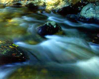
The Chattahoochee River begins as sparkling teardrops weeping out of the rocks on the southern edge of the Blue Ridge mountains, just below Brasstown Bald, Georgia's highest point at 4,784 feet. From its birthplace at Coon Den Ridge in Union County, it trickles through a lush forest of oaks and pines, ferns and rhododendrons, blackberries and buckberries, and, of course, pervasive poison ivy. Only a few inches wide at first, it soon is joined by other streams and widens to what some might call a mountain "creek." Eventually streams from Habersham, Lumpkin, Rabun, Towns, and White counties, as well as Union, broaden its shoulders.
If you are so inclined, you can climb to 3,600 feet or so, where Jack's Knob Trail dead-ends into the Appalachian Trail and see the origin of the river at Chattahoochee Gap. The spring lies about 200 feet south of the trail. Its only indication is a sign with a "W" (for "water") pointing downhill.
Or you can drive to Brasstown Bald for a panoramic view of the Upper Chattahoochee. On a clear day, Lake Lanier glistens on the horizon and the Atlanta skyline is visible. Rosebay rhododendron, mountain laurel, and mountain ash remind you that the city is farther away than it appears.
Much of the watershed along this upper stretch of the river is designated as the Chattahoochee Wildlife Management Area within the 750,000-acre Chattahoochee National Forest. More than 500 species of birds, mammals, fish, and reptiles live in this protected headwaters portion, with an estimated 1,000 miles of trout and warm-water streams dissecting the area.
This upper watershed is much healthier than it was in the 1920s, when the federal government began to buy the land that eventually was turned into national forest in 1936. For nearly a century poor farming practices, gold mining, and lumbering had degraded the land and water. The abuses began in the late 1830s, when the U.S. government forced out the Cherokees, who had lived there since at least the 1500s, and white settlers moved in. Today, though, you will see few signs of this earlier destruction as you hike the trails, canoe the streams, and camp in the recreation areas.
One of those trails will take you to Georgia's most visited waterfalls. The twin falls of Anna Ruby mark the junction of Curtis and York creeks, which begin on Tray Mountain. Curtis drops 153 feet and York 50 feet to form the falls that merge into Smith Creek, a tributary of the Chattahoochee.
By contrast, one of Georgia's best kept secrets is Horse Trough Falls, about 10 miles north of Helen. The flow from Little Horse Trough Creek spreads out across a massive rock face and plunges into a pool 75 feet below, just before the stream joins the river.
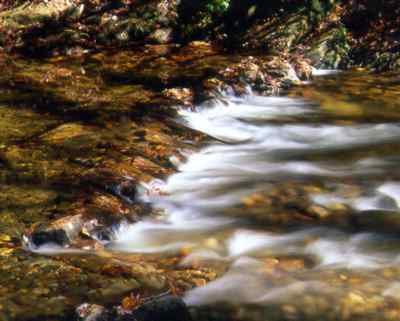
As it descends 1,580 feet in elevation and 14 miles in distance on its way to Helen, the first town along its journey to the ocean, the Chattahoochee picks up flow from creeks such as Smith, Low Gap, Henson, Dukes, and Sautee. Helen is a German-theme tourist town of festivals and businesses such as Alpine Village Outlets and Alpine Brew Package Store. A fast-food franchise now sits where the largest sawmill in the South used to slice timber from the mountains.
Degradation begins on the river above Helen, mostly from campers who destroy streamsides and don't care where they dispose of their wastes. But it is at this mountain town that the destruction first becomes truly visible. More and more development along the river is destroying the riparian buffer zone of plants that stabilizes the banks and keeps the water clear. The result is increased erosion that muddies up the river and contributes to the more than 200,000 tons of sediment that is filling up Lake Lanier, just downstream.
As the sediment load increases, the Upper Chattahoochee's value as a trout fishery correspondingly declines. The sediment smothers habitat, slows flow, and makes the water uncomfortably warm for cold-water fish.
From Helen, the river flows east through Nacoochee Valley, where humans are thought to have lived as far back as 14,000 years, the close of the last Ice Age. They buried their dead in mounds, still visible here.
Excavations suggest the Spanish searched for gold in the valley as long ago as the sixteenth century. The second gold search began in 1828, and once the stream beds were exhausted, miners began tunneling into the hills.
Just four years before the second gold rush, the first dam was built on the Chattahoochee to power a grist and lumber mill. In 1876, John Martin built the present Nora Mill, and he replaced the original dam in 1893. Today, this northernmost dam on the river is one of only 50 or so in the country still operating a water-powered mill. Nora Mill grinds cornmeal, grits, and whole wheat, rye, and buckwheat flours.
After it leaves this headwaters area, the Chattahoochee passes through at least 14 more dams on its way to the Gulf of Mexico.
Origin of the name "Chattahoochee" isn't nearly as certain as the birthplace of the river that carries the name. The most generally accepted story comes from the 1799 travel log of Benjamin Hawkins, an Indian agent:
"The name of the river derived from 'Chatto,' a stone, and 'hoche,' marked or flowered; there being rocks of that description in the river above Hoithletigua at an old town Chattahoochee."
Exact location of that old town remains a mystery, but most historians place it near the present town of Franklin in Heard County.
Living in the headwaters area, the Cherokee had named the river "Chota," which was also the name of a town in the Nacoochee Valley. When the river flowed into Creek territory, it became the "Chattahoochee."
When the Cherokees were forced out of their homeland, the name "Chota" disappeared with them.
The Chattahoochee, though, carried on, just as it had during the times of the mound builders hundreds of years before and just as it does today, when it helps grow peanuts and cotton in southwest Georgia, powers turbines, and flushes every toilet in Atlanta.
Over the centuries it served as possibly the most important route for connecting the Gulf of Mexico to the interior of the nation. It allowed for Indian tribes to travel and trade, and it provided entry for white explorers and settlers. The Spanish traveled up the river as early as 1639 and tried to establish exclusive trade with the Creeks.
By 1824, the federal government already had begun to "improve" the Apalachicola for commercial navigation. With the forced removal of the Indians, hundreds of steamboats began traveling the 262-mile waterway between the port town of Apalachicola and the Columbus wharf. Stopping at any number of the more than 200 landings along the way, the boats carried cotton bales downriver and brought back manufactured goods and food, including Apalachicola Bay oysters kept alive with cornmeal sprinkled in wooden barrels. The last steamboat to dock in Columbus was the George W. Miller in 1939.
In addition to the steamboat trade, grist, lumber, and textile mills flourished on the river, especially along the "fall line" between West Point and Columbus. During the 1830s, Columbus erected a dam to divert water to its business district, enabling it to become one of the South's most prominent industrial centers by the 1850s.
The fall line designates a dramatic change in character for the Chattahoochee, as it stops flowing from the mountains and starts running to the sea. Dropping more than 300 feet over 38 miles, the river historically raced over a long series of waterfalls and shoals created by the transition from Piedmont to Coastal Plain. The fall line provided the perfect setting for mills, as well as marked the end of navigable waters from the Gulf of Mexico. Millions of years before, the fall line had marked the edge of that same ocean body.
The richest land for farming along the river is just below the fall line. There the Chattahoochee drops its soil load across the bottomlands, and it was there that most of the Indian settlements occurred. The lower Chattahoochee, in fact, probably has the largest collection of archeological sites in Georgia, ranging from Paleo-Indian to Creek.
Farther upriver, the waterfalls and rocky creeks of the Brevard Fault also enabled mills to operate. The area around Hilly's Mill Creek and Red Bone Creek marks the point where the fault continues on into Alabama and the river turns south, forming the boundary between Georgia and Alabama. Since steamboats couldn't travel this far north, poled barges frequently moved cotton downstream to Columbus during the nineteenth century.
The Brevard Fault, which cuts diagonally from northeast Georgia to Alabama, probably is the Chattahoochee's most important geological feature and has contributed much to the scenic beauty of the river, both above and below Atlanta. A "fault" is the result of one part of the earth's crust moving or slipping in relation to another. In this case, the river flows through 100 miles of ridges, valleys, palisades, and waterfalls because of the fault.
Just as important to the character of the river is the fact that the Brevard Fault serves as the dividing line between the Appalachian Mountains and the Piedmont Plateau. The fault itself serves as a natural barrier to movement of flora and fauna between the two distinct geological regions. But plants and animals have migrated up and down the aquatic highway connecting the two, and thus have moved far outside of what might have been their natural range. Some species of salamanders and birds, for example, have made their way from the mountains to the Piedmont along the Chattahoochee, as have numerous species of trees. Beech, white oak, umbrella magnolia, tulip popular, black locust, and mountain laurel are but a few species that grow farther south than they might have if not for the Chattahoochee River and Brevard Fault.
Most all of the river along the fault lies exclusively in Georgia, but when the fault continues on past Heard County and into Alabama, the Chattahoochee turns more southerly, forming a 200-mile boundary with Alabama and a small portion of Florida.
On its way to flush 16 billion gallons of water a day into Apalachicola Bay, the Chattahoochee drains an estimated 8,770 square miles. The Flint drains another 8,460 square miles and the Apalachicola 2,370, so that the combined watershed of the system is an impressive 19,600 square miles. More than 70 percent of that lies in Georgia.
Cherokees, Creeks, and other tribes built cities along the Chattahoochee River long before Europeans arrived. The most prominent were south of the fall line, and included Coweta Town, Cusseta Town, and Apalachicola Town, all of which probably had thousands of inhabitants during the 1500s and 1600s. Historians believe Cusetta Town might have been the largest Indian settlement in the Southeast by 1800 and may have rivaled Charleston in population.
Up near present-day Atlanta, Standing Peachtree was one of the most important trading villages. During the War of 1812, Fort Peachtree was built to protect white settlers from the Creeks, who were allied with the British.
Sitting at the head of navigable waters, Columbus quickly became the most prominent Georgia town established by white settlers on the Chattahoochee. Cotton and other goods produced in Georgia and Alabama were brought in by wagons and barges for shipment by steamboat to the Gulf of Mexico and beyond.
As railroads began to compete with steam in the 1850s, Columbus lost some of its importance as a transportation center. Its riverine location, though, allowed it to continue to thrive, harnessing the river with dams to power textile, grain, and lumber mills. Dams still play an important role in Columbus today, as four in the city and five more to the north provide hydro power and help control floods that traditionally inundated the area.
While railroads diminished the importance of Columbus, they established Atlanta as an important business center. Even though the Chattahoochee was nearby, the city paid little attention to her until midway through the twentieth century. Since then, this fast-growing metropolitan area has awakened to the importance of the river for water supply, waste disposal, and recreation. Additionally, it has begun to sprawl nearer and nearer to the 48 miles of river that runs between Buford Dam and Peachtree Creek.
Because of this ill-planned growth, raw sewage from Atlanta's antiquated and inadequate sewer system has been degrading the river for more than a decade and destroying quality of life for those who live along the Chattahoochee. Foul odors and fish consumption advisories keep many away from the river for miles downstream of Atlanta.
"From Peachtree Creek down to that South Fulton Camp Creek discharge, the river is disgusting," says Sally Bethea, Upper Chattahoochee Riverkeeper, in The Riverkeeper's Guide to the Chattahoochee, a 334-page recreational guidebook published by her watchdog organization. "There's no way to get on it because nobody wanted to get on it. It smells like chlorine. Or sewage. Or other strange chemicals. The trash is unbelievable."
Farmer Doug Daniell of Douglas County adds, "Sometimes it smells so bad, it makes your stomach hurt." The odor is the worst, he says, when rain upstream makes the river a witch's brew of poison runoff and raw sewage.
Ironically, as Atlanta has continued to destroy a good portion of the river below the city, its citizens have been enjoying more and more of the Chattahoochee River National Recreation Area (CRNRA). This 48-mile stretch of river above the sewage outflow includes 16 separate parks along both sides of the Chattahoochee's banks where visitors can fish, picnic, and hike among azaleas, dogwoods, redbuds, scarlet sumac, and trout lilies.
Bowman's Island is the northernmost unit and one of the most beautiful sections of the CRNRA. The river's clear, cold waters run for about 2 miles downstream from Buford Dam, providing excellent opportunities for canoeing and trout fishing. Sycamore, red maple, river birch, and ash provide a leafy corridor from spring through autumn.
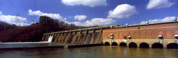
Chattahoochee River Park is a more popular and crowded facility near metro Atlanta. Facilities include a launch site, picnic tables, and a hiking trail. The park is also the last take-out for canoes before Morgan Falls Dam, a significant landmark on the Chattahoochee. When completed in 1904, Morgan Falls produced Atlanta's first hydroelectric power, much of it used to run the Atlanta streetcar system.
Dams have been built on the Chattahoochee River since the early 1800s, but construction on the ones that truly changed the face of the river didn't begin until the mid-1950s. Until that time, dams were mostly small affairs used to power mills and provide hydro power. They didn't alter flow much.
But beginning with Lake Sidney Lanier and Lake Seminole, the U.S. Army Corps of Engineers constructed dams that stopped the river, creating massive impoundments for flood control, water supply, power, and commercial navigation. The big four reservoirs include Lanier, above Atlanta, with 38,000 acres and 540 miles of shoreline; West Point Lake, just downstream from Atlanta, with 25,900 acres and 525 miles of shoreline; Lake Walter F. George ("Eufaula" on the Alabama side) with 45,180 acres and 640 miles of shoreline; and Seminole with 37,500 acres and 500 miles of shoreline.
Except for West Point, recreational opportunities were given little consideration when these impoundments were built, but today more than 20 million people annually visit them to fish, boat, ski, swim, and camp. All four have been noted at one time or another as among the nation's best bass fisheries.
Lanier, a water supply reservoir for Atlanta, is arguably the most important lake in Georgia and possibly the Southeast. It also is one of the most visited Corps facilities in the country and a much desired location for elegant weekend and retirement homes. With 23,000 boats, 10,000 lakefront homes, and 7,200 private docks, the lake is being loved to death. Pollution from sewage plants, septic systems, boats, and poultry processors, along with poison runoff from developed areas, is destroying water quality, while erosion of the shorelines is filling in the lake. On the positive side, citizens groups such as Lake Watch have done much to educate the public, curtail pollution, and preserve the lake.
West Point, meanwhile, has been both hurt and helped by its location just south of Atlanta. Fish consumption advisories precipitated by toxins from upstream have harmed it, giving the general public the perception that West Point is among the state's most polluted lakes. It also has been damaged by the nutrient overload of nitrogen and phosphorous from Atlanta sewers, which is aging the lake prematurely.
Those same nutrients, though, have made West Point a fertile fishery for largemouth bass and hybrid striped-white bass and consistently one of the top lakes in the state for angling success.
In recent years, laws mandating use of low-phosphorous detergents and sewer plant upgrades have helped lower the nutrient load and diminish algae growth in West Point. With this improvement in water quality, oxygen levels now go deeper during the summer months, meaning less chance of a fish die-off during this stressful time.
Downstream, the lake that has two names has benefited from West Point's absorption of Atlanta's pollution. Lake Walter F. George-known as "Eufaula" on the Alabama side-has generally maintained good water quality and a good reputation over the years. This has allowed recreational activities on the lake to provide a considerable boost to the Clay County economy.
Pollution from nearby Columbus does impact the lake, as does industry on the Alabama side, but it is not of as much concern as that degrading Lanier and West Point. Erosion of surrounding farmland probably poses the greatest threat to the continued good health of this reservoir.
Siltation also is the biggest problem facing Lake Seminole, the last reservoir on the Chattahoochee. Fed by both the Flint and the Chattahoochee, this shallow, weed-filled lake is surrounded by pine bluffs and hardwood bottomland, and it is noted for its scenic beauty, as well as bountiful populations of ducks, geese, herons, and other aquatic birds. Unlike the other lakes, not much development has grown up around it, and, consequently, deer, turkey, raccoons, possum, and other animals that range up and down the river seem especially concentrated here. Alligators roam these waters too, and nearly 100 pairs of ospreys and 50 pairs of bald eagles nest here, according to Jack Wingate, whose Wingate's Lunker Lodge is a long-time fixture on Lake Seminole.
South of Lake Seminole, the Chattahoochee River enters Florida and acquires a new name-the Apalachicola. The change stems from more than 300 years ago when the Spanish claimed the area and named the waterway the Rio de Apalachicola. When the British ruled, the river was called the "Chattahoochee." Eventually, the name officially changed at the territorial border between the two colonial powers.
Long before the river had any name at all, the Apalachicola was but a small tributary of the Chattahoochee. But the Apalachicola eroded a valley through the hills of north Florida until it captured the Flint. Denied its major tributary, the Chattahoochee moved east until it rejoined the Flint to form the modern arrangement of the three rivers.
Today, the Apalachicola pours out of Lake Seminole through Jim Woodruff Dam and meanders 107 miles to nourish Apalachicola Bay with 16 billion gallons of freshwater each day. In terms of flow volume, it is Florida's largest river.
That volume enables Apalachicola Bay to be the most productive estuary in the Northern Hemisphere. It works like this:
The river floods hardwood swamps and sends nutrients into the shallow water of the bay, which is 55 miles wide and 6 miles at its longest. The Apalachicola River's flow also protects oysters from oceanic predators that can tolerate much less fresh water than the valuable shellfish.
The barrier islands of St. Vincent, Little St. George, St. George, and Dog hold the flow in the bay long enough for fresh water to mix with salt water and deliver leaf-litter nutrients. The saltwater marshes provide food also, as well as act as filters for pollutants and nursery habitat for young shellfish and finfish.
"This river swamp is as productive as a corn or wheat field fertilized by man-only Mother Nature does it free," says Woody Miley, environmental administrator for the Apalachicola National Estuarine Research Reserve. "What we have to realize is that each component is a critical part of the chain. If you break one of the links, you no longer can use the chain."
Out among the gold orb spiders, the swamp lilies, the turtles, and the wood ducks of the swamp, tupelo trees form one small, but significant link in that chain. "Tupelo trees make the finest honey," Miley says. "And we've got the largest stand of them in the world. It's a half-million-dollar industry. The bees are moved in and out by boat."
On downstream, an estimated 95 percent of all shellfish and finfish species harvested commercially and 85 percent of all species harvested recreationally spend a portion of their lives in Apalachicola Bay.
Retail value of the bay's seafood is estimated at more than $100 million a year. That includes 2 to 6 million pounds of oyster meat a year and 4 to 7 million pounds of shrimp. To put the value of the bay into a little more perspective, it yields 90 percent of the oysters harvested in Florida and more than 10 percent of those harvested nationwide.
To maintain that production, Apalachicola Bay must continue to receive its massive influx of fresh water. In recent years, especially during times of drought, saltwater encroachment has damaged the oyster harvest, as has pollution and overfishing.
"Water quantity is at least as important to survival of the bay as water quality," says Miley. "Floods are essential for high seafood production. But needing floods is a hard concept to sell to Georgia and the Corps."
Eighty-four percent of the water that feeds the bay originates in Georgia and Alabama, and, as an allocation plan is implemented to divide the water among Georgia, Alabama, and Florida, he adds, floods could be lost and the bay would literally starve.
"What people have to realize is that everything that happens upstream affects us down here."
 The
Future
The
FutureProtecting the bay and other ecosystems of the Apalachicola-Chattahoochee-Flint (ACF) River system is one of the goals of the newly formed Tri-State Conservation Coalition, which includes the Georgia Wildlife Federation among its members. Coordinated by the Upper Chattahoochee Riverkeeper (UCR), this group intends to use "science, policy, advocacy, education, and legal action if necessary to promote sound management of these basins, which provide drinking water for millions of people, habitat for a rich array of aquatic organisms, and outstanding recreational opportunities."
Other members of the coalition include American Rivers, Apalachicola Bay & River Keeper, Inc., Bass Anglers Sportsman Society (BASS), Chilton Pride, Florida Wildlife Federation, Georgia River Network, Southern Environmental Law Center, and Wildlaw.
The states of Georgia, Alabama, and Florida were to have presented their plan for dividing up the water of the Apalachicola, Chattahoochee, and Flint rivers for federal approval by December 31, 1999, but negotiators missed the deadline and have extended it to May 1, 2000.
What the coalition wants is an allocation formula that is protective of water quality, biodiversity, and recreation, while allowing for economic growth, according to Matt Kales, the UCR's program manager for River Basin Protection.
"This is a complex issue, and all sides will have to give a little," says Jerry McCollum, GWF president. "But we will need a decision that is not based solely on industrial needs. Human needs and natural resource needs should be higher on the scale than I have seen them to date. The coalition will give us a forum to voice our concerns about that.
"We represent private citizens," he adds. "Thus far, the state and federal agencies involved seem to be leaving out the concerns of the citizens in favor of industry. Economic growth is important, but when you are at the limits of a resource, as we are with the Chattahoochee, you have to remeasure your standards."
Bruce Shupp, BASS national conservation director, adds, "We need to maintain various levels of flow at different points in the system. Where water quality is bad, if you don't maintain occasional flushing flows, you will have fish kills."
Flushing flows become increasingly important as the river nears the ocean, says Kales. "Life in Apalachicola Bay and Mobile Bay depend on them. What Atlanta does (withdrawing water and discharging pollution) has consequences downstream."
Flushing flows, for example, send much-needed nutrients from upstream swamps into the bay. They also prevent saltwater encroachment too far up the system and provide sediment that creates protective barrier islands.
Founded in 1994, the UCR deserves much of the credit for improvements along the Atlanta stretch of the river. Because of its work, the future looks much brighter for the much used and abused Chattahoochee than it did just a few years ago. The watchdog group educates and sponsors workshops; patrols and monitors the river; lobbies and initiates legal actions; and leads cleanups and pilot projects to improve water quality and stabilize banks.
"During the last five years, the public has realized that there is a Chattahoochee River that can and will be restored, especially below Atlanta," says Sally Bethea, Upper Chattahoochee Riverkeeper. "For decades, the river below Atlanta was written off. That's not the case anymore.
"With heightened public awareness and various enforcement actions and initiatives in place, we should see dramatic improvements during the next five years."
Read and add comments about this page
Go back to previous page. Go to Chattahoochee River contents page. Go to Sherpa Guides home.
[ Previous Topic | Next Topic ]