| |
The Natural Georgia Series: Barrier Islands |
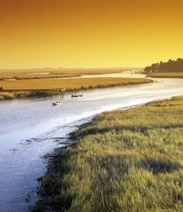
People traveling I-95 often pass through the steamy pinelands of Georgia's Coastal Plain without a clue that 10 miles east exist some of the world's most beautiful barrier islands. Few places have such expansive beaches with meadows adorned with colorful wildflowers 10 months of the year and dunes topped with golden sea oats swaying in the sea breezes. On the western side of the barrier islands are the vast green marshes lined with dark green needle rush, cedars, and cabbage palms. Capturing attention are the live oaks with their burly trunks and spreading crowns festooned with Spanish moss. Unlike many of America's shorelines, whose beaches and barrier islands are being lost to development, many of Georgia's islands still retain much of their native wilderness. Approximately two-thirds of the islands are state and national parks, wildlife refuges, research reserves, and heritage preserves. The name "barrier" has been given to these islands because they protect the mainland from storm waves and the strongest winds. Clay and sand sediments carried in the incoming tides and rivers settle behind the barrier islands to form the marshes.
Georgia's barrier islands are actually the midsection of a system of oak-shrouded, sandy barriers that extend from the middle of the South Carolina coast to the mouth of the St. Johns River in Jacksonville, Florida. Georgia is the most westward location of the Atlantic seaboard, placing its barrier islands in the approximate center of the inward-curving coastline known as the South Atlantic Bight and 60 to 70 miles from the edge of the continental shelf (continental slope).
This position of the barrier islands relative to the South Atlantic Bight affects Georgia's tides, waves, and incidences with hurricanes. As oceanic tides, having an average range of 2 to 3 feet, funnel into the bight, the water piles up on itself, creating an elevated tidal range of 6 to 9 feet and making Georgia's tides the highest of the Atlantic seaboard south of New York. The shallow slope of the continental shelf, averaging about 2 feet per mile, dissipates the energy of the large waves coming in from the open ocean. Waves move across the broad, shallow shelf waters and lose energy as they drag along the bottom and break over the many offshore shoals before arriving on beaches. Since the Gulf Stream, in its wandering way, basically follows along the edge of the continental slope, Georgia's shores are also remote from the Gulf Stream. Hurricanes that approach our shores from the Atlantic tend to veer northward as they follow the warm air over the Gulf Stream, frequently causing them to miss our small 100-mile-long shoreline and make landfall farther north or go out to sea.
 The
eight barrier island groups that skirt the Georgia coast are made up of two
sets of islands that formed during distinctly different geologic time periods.
The extremely gradual slope of the Coastal Plain and continental shelf coupled
with the high tidal range of 6 to 9 feet creates the rare condition of tidal
water completely surrounding both sets of barrier islands. Georgia is different
from the majority of coasts where older sets of barrier islands become integrated
into the mainland, leaving only the most recent set of barriers surrounded with
water and marshes.
The
eight barrier island groups that skirt the Georgia coast are made up of two
sets of islands that formed during distinctly different geologic time periods.
The extremely gradual slope of the Coastal Plain and continental shelf coupled
with the high tidal range of 6 to 9 feet creates the rare condition of tidal
water completely surrounding both sets of barrier islands. Georgia is different
from the majority of coasts where older sets of barrier islands become integrated
into the mainland, leaving only the most recent set of barriers surrounded with
water and marshes.
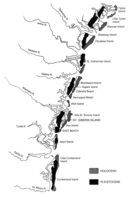
The older and innermost set of islands, the Pleistocene islands, harbored Georgia's beaches 35,000 to 40,000 years ago before the last great ice age. St Simons, Sapelo, and Skidaway islands are examples. The Holocene islands, Sea Island, Little St. Simons, Wassaw, etc., were formed 4,000 to 5,000 years ago with the rise of the sea level after the last ice age (see Figure 1).
Seven sequences of barrier islands have been identified between the present-day shoreline and the Okefenokee Swamp, 40 miles inland. All of these have formed with the vacillation of the sea level over 100 miles between the Okefenokee Swamp and the outer edge of the continental shelf. The water level changed in response to major climatic changes, the ice ages, over the past million or so years. The oldest and largest of Georgia's relic barrier islands is Trail Ridge, which formed when the sea level was approximately 170 feet above what it is today. The island's great size and position obstructed the drainage of the 700-square-mile basin behind it to eventually form the Okefenokee Swamp after the sea level declined at the advent of the ice ages.
Georgia's barrier islands have four general ecosystems, the ocean beach, salt marsh, maritime forest, and freshwater sloughs. Let us explore the nature of these areas and, where applicable, compare these to other barrier islands of the East Coast.
Georgia's beaches are characterized by wide, wet (intertidal) beaches with hard-packed sand, and narrow or nonexistent upper, dry-sand beaches. Since the tidal range is great and the slope of the beaches is gradual, this area of wet sand can extend over 0.25 of a mile out to sea during low tide, and on the northern ends of islands where inlets have not been dredged, sand can be seen for several miles offshore because of the inlet shoal formations. Except during storms, the waves on Georgia's coast are small and lack the energy to wash in large shells and the courser offshore sand. This is why the sand is so fine and most of the time shelling leaves something to be desired. In comparison, on the coasts of North Carolina and New Jersey, which have moderate tidal ranges and heavier surf, the sand is courser with more shell material, beaches are steeper in slope, and there is a wider zone of dry sand on the beaches for sunbathers.
Having played on the beaches of New Jersey and surfed its breakers through my teenage years, I can understand the complaints of fellow Jerseyites about Georgia beaches, "the yucky wet sand that sticks to you, the lousy waves for riding, no shells, and it doesn't even smell like the seashore." But the beaches of Georgia have their perks. With an offshore swell and an easterly breeze, decent riding waves can appear in Georgia for an hour or more during the high tide, usually during the late summer and fall with the advent of offshore, tropical disturbances. The ocean smell comes with the larger breakers. Shelling on Georgia's beaches is excellent after tropical storms and northeasters, and there are tropical as well as temperate shells to choose from. Georgians can also bicycle and comfortably walk many miles on their beaches, while residents and visitors of higher energy beaches like New Jersey cannot because of the soft sand.
The silicate sand of many of the temperate zone's beaches originates from rock that has been broken down and crumbled by pelting rain and ice, intermittent freezing and thawing, and carbonic acid, a chemical in rain water that forms from the dissolving of carbon dioxide in the atmosphere. Rain washes gravely rock fragments into steep, fast-moving mountain streams. Over time, the gravel is milled into coarse sand by the turbulent water movement and through collisions with rocks in the streambed and with other eroded suspended rock fragments. The sand eventually is carried by rivers to the ocean, where tides and longshore currents distribute the sand along the beaches.
On the West Coast the mountains are located close to the beaches and newly formed sand regularly washes down from the mountains to the sea. The sands of the West Coast are usually coarse because of their speedy journey to the sea. The sands of the middle and south Atlantic coasts are finer grained. The mountains are much farther from the coast and rock fragments carried by streams rarely make it to the coast. In Georgia, sands coming from mountains are deposited in the slow, meandering streams of the lower Piedmont and Coastal Plain. Some of the prettiest, white sand beaches are seen in streambeds like that of the Satilla River near Waycross, some 60 miles inland. Most of the sand on the Atlantic shores is ancient Pleistocene sand that is thousands of years old. This sand was deposited on the beaches when the sea level was closer to the Appalachian Mountains during the Pleistocene Epoch. Hence, the sands of the middle and south Atlantic coasts have been swilling about for a long time and are well milled. The action of low-energy waves sorts out the finest of these sands to be deposited on Georgia's beaches.
 Beaches
are some of earth's most dynamic ecosystems, with the force of the ocean on
one side and the ever-changing land profile and continuously invading biological
communities on the other side of these little strips of sand. The success of
this ecosystem depends on its flexibility. During storms when the wave energy
is high, breakers scour sand from the beach and dunes and deposit it on offshore
shoals. As the shoals build up, they cause the larger waves to break on them
("tripping" the waves) before they arrive on the beach. This way the
breakers lose much of their energy by the time they arrive on the beach. The
sand dunes and back-beach areas act as sand reservoirs which, when excavated
by the waves, release more sand for further shoal development. The eroded sand
dispersed into the swirling waters further wears down wave energy as the backwash
drags the heavy, sand-laden water into the surf zone. The sum of these effects
suppresses further sand loss from the beach.
Beaches
are some of earth's most dynamic ecosystems, with the force of the ocean on
one side and the ever-changing land profile and continuously invading biological
communities on the other side of these little strips of sand. The success of
this ecosystem depends on its flexibility. During storms when the wave energy
is high, breakers scour sand from the beach and dunes and deposit it on offshore
shoals. As the shoals build up, they cause the larger waves to break on them
("tripping" the waves) before they arrive on the beach. This way the
breakers lose much of their energy by the time they arrive on the beach. The
sand dunes and back-beach areas act as sand reservoirs which, when excavated
by the waves, release more sand for further shoal development. The eroded sand
dispersed into the swirling waters further wears down wave energy as the backwash
drags the heavy, sand-laden water into the surf zone. The sum of these effects
suppresses further sand loss from the beach.
When surf energy is not as high, the action of the waves gradually transports much of the shoal sand back onto the beach. The inward-migrating sand often collects into mounds roughly parallel to the shoreline on the intertidal zone. Where the newly deposited sand meets the sand on the beach a gully, called a runnel, often forms along the back side of the mound (see Figure 2). Sea breezes blow intertidal sand, which has become sufficiently dry during a lower tide, to the back beach areas where it rebuilds the upper beach and dune systems. This perpetual homeostatic mechanism is often called the sand sharing system.
Paradoxically, beaches have become highly esteemed by people as places to
live. Building static structures (homes, condominiums, hotels, etc.) in the
world's most dynamic and dangerous environment does not reflect well on humankind's
endowed wisdom. The many expensive attempts to save developed frontage and restore
retreating beaches through the use of seawalls, groins, and beach renourishment
procedures have, more often than not, accelerated the loss of beaches. More
than a century of armoring and developing shorelines is making natural, self-sustaining
beaches endangered species. 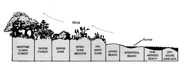
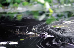
Beaches are harsh environments for life. The intertidal zone, the area of the beach that is covered and exposed with the changing tides, is neither truly terrestrial nor aquatic and has the extra enemy of constantly shifting, pounding surf. This zone is sometimes referred to as the "graveyard of the ocean." Most things seen in the intertidal zone are usually dead or dying or are scrambling to get away. The shells, dead crabs, egg cases, and the like washed up onto the beach are not, as some think, remains of beach animals. They are from dead marine organisms.
Many of the living animals of the sandy beach, such as small annelid worms, amphipods, and a variety of protozoans, are not seen because they are tiny and living among the sand grains under the surface. The larger beach animals such as ghost shrimp, ghost crabs, and a number of polychaete worms live in burrows. Occasionally one encounters a ghost crab or sandy-colored tiger beetle gliding over the dry sand of the upper beach, or a moon snail or olive shell leaving trails in the wet sand, or mole crabs and coquina clams filter-feeding in the backwash of the surf. The sandy beach and exposed shoals are a visiting place for a wide variety of aquatic and terrestrial life. Marine animals come in with the tide to feed and to escape from enemies, and those that die or are left stranded by the retreating tide become food for the shorebirds, raccoons, rats, and insects from the land.
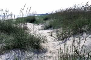
The upper dry beaches and dunes are ephemeral and are subject to being washed away by passing storms with high surges, only to have to again undergo the process of succeeding back to their original state. When fully established, these areas are harsh environments for plants. Desiccating winds, salt spray, sterile and fast-draining soils, and shifting sand are factors causing these areas to become "deserts of the beach." Many resident plants have developed adaptations similar to those of desert plants. Plants such as sea rocket, sea-purslane, and fiddle-leaf morning glory survive by having thick, succulent leaves. The yucca and prickly-pear cactus (devil-joint) are desert plants that also do well on beaches and cause pain to many who walk in these dry meadows. Most of the other plants on top and between the primary dunes, such as sea oats, bitter panic grass, sandspurs, beach elder, and beach croton, have extensive fibrous root systems that spread just underneath the surface of the sand catching water as it quickly percolates. Root competition is stringent in these shifting, nutrient-poor beach soils. A supplementary supply of plant nutrients comes from the many salts, i.e. magnesium, potassium, calcium, manganese, and others in the seawater spray deposited on the ground. Though harmful on plant tissue, much of the sodium chloride is diluted by the rainwater and dew on the soil surface.
Sea oats are the master dune builders. Their long curly leaves and tall oat heads trap wind-blown sand, burying themselves and neighboring plants. By growing vertical runners, which produce daughter plants on the surface of the growing dune, sea oats stay ahead of the accumulating sand, while most of the other competing plants become buried and die and eventually provide humus for the sea oats. This is why the tops of many dunes often have almost pure stands of sea oats growing on them. Because of their vital role in building and stabilizing dunes, sea oats are protected by law; there is a stiff fine for picking or otherwise damaging the plants.
Back from the primary dunes, many of the plants mentioned above gradually yield to a variety of flowering weeds, grasses, and woody plants that make this area a beach meadow. Here, the beach soils have had sufficient time to develop with the passing generations of plant and animal communities opening the way for the colonization of these highly competitive, dry-field plants.
 The
greatest variety of plants in the beach meadows is found in the swales, or areas
between the dunes where the soil surface is better protected from wind and is
closer to the groundwater. These areas are often called interdune meadows. Flowering
weeds, such as camphor weed, wild bean, butterfly pea, cassia, partridge pea,
dune primrose, spurge-nettle, muhley grass, and firewheels color the meadows
through most of the seasons of the year.
The
greatest variety of plants in the beach meadows is found in the swales, or areas
between the dunes where the soil surface is better protected from wind and is
closer to the groundwater. These areas are often called interdune meadows. Flowering
weeds, such as camphor weed, wild bean, butterfly pea, cassia, partridge pea,
dune primrose, spurge-nettle, muhley grass, and firewheels color the meadows
through most of the seasons of the year.
The taller dune ridges of the beach meadows often continue to support sea
oats and sparse communities of plants more typical of the primary dunes. Because
of their higher elevation, the dune-ridge communities are exposed to salt-laden
winds that severely desiccate plant tissues. Soil development is retarded by
winds blowing away most of the dead plant and animal materials accumulating
on the surface of the dunes. Poor water retention and remoteness from the groundwater
keep the dune soils dry. Soil development on dunes is sufficiently retarded
so it is not uncommon to have sea oats covering dune ridges in shrub zones and
in forested areas well behind the beach. 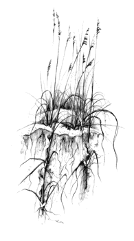
As beach soils continue to age and develop, woody shrubs invade the area. As they become established, they shade out most of the sun-loving meadow plants and sea oats, setting into motion a succession of changing plant communities leading to a shrub forest. Pine, wax myrtle, yaupon holly, red bay, red cedar, and a variety of hybrid oaks become entangled with cat brier, pepper vine, Virginia creeper, muscadine grape, and other vines to become ragged shrub forests that are an important sanctuary for the wildlife of the barrier islands. The sounds and colors of the yellow-rumped warblers, cardinals, Savannah sparrows, towhees, and painted bunting witness to the abounding life here. Deer, snakes, rabbits, and raccoons seek the shade and protection of the shrub forest. Clearing out the shrub forest between shorefront development and beach poses a great threat to the island wildlife.
As the soil continues to improve, live oaks, pines, and woody vines eventually form a canopy that shades out many of the shrub-forest species. Others of the shrub community, such as red bays, wax myrtles, red cedars, and hollies, become part of the understory of the developing maritime forest. It takes a century or more to develop a live oak maritime forest from a beach.
From a distance in an airplane or boat, the somber, dark gray-green live oak canopy covering the islands is the most distinctive feature of Georgia's barriers. The larger trees of the maritime forest, such as live oaks, southern magnolias, pines, and cabbage palms, intertwined with numerous woody vines, form the forest canopy. The canopy shadows and shelters the life underneath and retains moisture in the forest's air and soils. The atmosphere inside a forest is noticeably more humid than in the open. Shrubs and smaller trees, such as red bay, yaupon holly, American holly, sparkleberry, cherry laurel, and wax myrtle form the understory.
The canopy and understory provide abundant nesting sites and runways for woodpeckers, blue jays, parula warblers, wood thrushes, and other forest birds, as well as squirrels, green anoles, yellow rat snakes, tree frogs, and other arboreal animals. Saw palmettos, shade-loving flowers, ferns, and young generations of shrubs and trees form the ground cover. The never-ending shower of nuts, fruits, leaves, rotting bark, and broken branches feeds the animals of the forest and contributes to the accumulating litter on the forest floor. While walking through these beautiful woods, one must always be careful of the occasional Eastern diamondback or pygmy rattlers that seek shelter among saw palmettos and forest litter.
It is surprising that maritime forests on the younger (Holocene) islands are supported by such nutrient-poor soils (see Figure 1). The high humidity coupled with the long summers of 90-plus-degree temperatures facilitates rapid decay of the dead materials on the forest floor. In this way, plant nutrients are continually released to replenish the soils. Except in watery sloughs, the topsoil in maritime forests is only a few inches deep sitting on top of plain sand. It is the decay of the daily organic fallout from the plants and the animals that maintains the forest ecosystem. Most of the trees of the forest have shallow, wide-spreading root systems that quickly glean nutrients from the rainwater as it percolates through the decaying leaf litter. There is an interesting association between live oaks and a fungus, mycorrhiza. The fungus grows on the delicate root tips (root hairs) of live oaks and greatly increases the root's surface area for absorption by taking in water and dissolved nutrients for itself and for the tree. Mycorrhiza associates with some plant species of the beach meadows and other areas with poor soils.
These forests are very fragile. It may take centuries for a maritime forest
to replace itself if completely destroyed. Without the root structure and the
shelter of the trees, the thin layer of topsoil is easily carried off with winds
and water. Without the trees and forest animals to supply the soil with dead
leaves, feces, carcasses, and other organic fallout, the raw materials for building
topsoil are lost. For years only the hardiest of weeds and grasses can grow
on such wastelands. From there begins the slow, tortuous process of plant succession,
fraught with countless setbacks from wind and storms, leading to the eventual
development of a maritime forest. 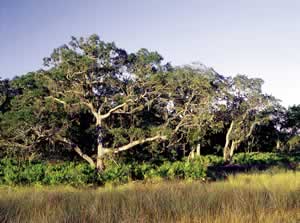
The maritime forests on the older Pleistocene islands have a greater species diversity because the soils are thousands of years older (see Figure 1). Red maple, pignut hickory, water oak, laurel oak, sweet gum, and tulip are some of the trees that share the canopy with live oaks and pines on the Pleistocene islands. It was, after all, the soil of the Pleistocene islands that supported the culture of Sea Island cotton for over a century. Because of the extensive clear-cutting for cotton growing, most of the older (Pleistocene) islands have young, second-growth forests with a high content of loblolly pine. This is especially noticeable on Sapelo, the midsection of Jekyll, and St. Simons islands where large, antebellum cotton plantations existed.
When fires burn live oak forests, loblolly and slash pines often take over, due to their ability to rapidly grow in poor, fire-cooked soils. Unlike oaks and other hardwoods, pines are unable to succeed themselves without frequent fires or clear-cutting by man. The young, sun-dependent pines cannot grow in the shade of the parent trees. That is why pine stands often have trees of similar height and age. Shade-tolerant hardwoods, however, do grow among the large pines and quietly "wait" for the great pines to fall from old age or disease, so the hardwoods can take over the canopy. Live oak forests are the true climax forests because they maintain themselves by subsequent generations replacing aged trees.
On the other hand, hardwoods are easily destroyed by fire, while pines have evolved extraordinary fire-resistant adaptations. Pines are insulated from the fire's heat by air trapped in their thick, loosely layered bark. When the outer layers of the bark are burning, they often curl and fall to the ground, carrying with them hot embers that could otherwise damage the cambium (the living tissue layer just under the bark). When mature, pines' 90-to-120-foot-high crowns are well out of reach of the flames of most forest fires in the Southeast. In areas where fires are frequent, pine forests predominate and are sometimes referred to as "fire climaxes."
Man often simulates the fire climax condition by setting controlled fires in cultivated pine forests to control hardwood undergrowth. Control fires also rid the pine stands of woody shrubs and weeds, which act as fuel to make naturally occurring fires hotter and more destructive. As mentioned earlier, stands of loblolly pines are often indicators of past farming activity. Their ability to grow fast and tolerate poor soil allows the pines to take over the exhausted fields left fallow after years of intense cultivation.
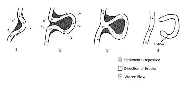
Freshwater sloughs come in many forms, from temporarily water-saturated areas and ephemeral ponds to large, more permanent ponds, freshwater marshes, and swamps. Many sloughs originate in swales or low areas between sand dunes of a beach where sufficient clay sediments have accumulated to allow the soil to hold water. If the beach has been accreting (growing) over the years, the same slough may be surrounded by a changing succession of meadow plants and shrubs, and eventually find itself in a maritime forest. Sloughs also originate from segments of marsh creeks that have lost their tidal flow often through the meandering of a creek (see Figure 3). These stranded tidal creeks, often in the form of oxbows, develop into freshwater sloughs.
 Larger
sloughs may develop into swamps with their own assortment of wetland trees,
i.e. cypress, tupelo, bay, buttonbushes, and red maples. Mature cypress is seldom
seen on many of the barrier islands because extensive farming, land filling,
and logging took the cypress and destroyed its habitats. On the mainland, isolated
stands of young second-growth cypress are common along roadsides and parking
areas that border wetlands.
Larger
sloughs may develop into swamps with their own assortment of wetland trees,
i.e. cypress, tupelo, bay, buttonbushes, and red maples. Mature cypress is seldom
seen on many of the barrier islands because extensive farming, land filling,
and logging took the cypress and destroyed its habitats. On the mainland, isolated
stands of young second-growth cypress are common along roadsides and parking
areas that border wetlands.
Sloughs are an important source of fresh water for the wildlife of the barrier
islands especially during the frequent periods of drought. During the summer,
continental storms are diverted around a large high-pressure system, known as
the Bermuda High, which settles in the Southeast for long periods of time. Most
summer rains, then,
come from local convection storms that often fail to produce rain for weeks
and even months at a time. During the winter and spring, the frequently seen
weather fronts that are oriented northeast-southwest often stall out or go northward
before reaching the coast. With these fickle weather patterns typical of Georgia's
coast, the possibility of drought is never
far away.
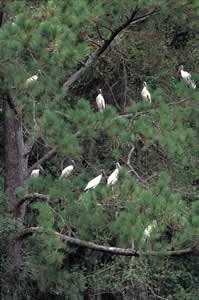
The deeper, shaded maritime-forest sloughs are a lifeline to the islands during droughts because they often have water in them long after other sloughs have dried up. Many of the larger island sloughs were drained, the forest cleared, and the land leveled for agriculture during the plantation period (1780-1880); and to some extent this trend continues today with barrier island development along the Atlantic coast. As a result, barrier islands are less able to supply their wildlife with fresh water, and habitat destruction is dangerously diminishing wetlands crucial for rookeries and nesting sites for herons, egrets, ibis, and endangered wood storks.
On the west side of the barrier islands lie the salt marshes. They occur between the older and newer sets of islands and between the older islands and the mainland. Marshes extend well into the mainland, following the major rivers and occupying some of the low areas surrounding still older sets of barrier islands. The large tidal range, together with the gentle slope of the Coastal Plain and continental shelf create the extensive, 4-to 8-mile-wide marshes between the islands and the mainland. The coast of Georgia is only 100 miles long, yet its one-half million acres of salt marsh constitute nearly one-third of all the salt marshes of the eastern Atlantic states. The sheer breadth of these impressive marshes can be perceived from causeways leading to any of the barrier islands and from Highway 17 as it skirts the marshes throughout much of Glynn County.
Marsh creeks, sounds, and inlets are all part of estuaries, where seawater meets and mixes with fresh water from the coastal rivers and runoff from the surrounding uplands. As seawater moves into the estuaries, its salinity (salt concentration) decreases as it mixes with the brackish and fresh water coming from the mainland. The daily overall salinity of the marsh and estuaries may fluctuate widely with the amount of rainfall and the height of the tides.
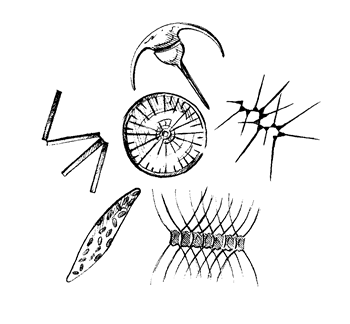
Similar to the beach and maritime forest, the marsh is also a harsh environment for resident plants and animals. The major conditions that severely limit resident life in the marsh are the intermittent exposure to air and saltwater as the tides rise and fall; the rapid changes of water temperature and salinity with the interchange of the river waters and the incoming seawater; and the saturated, anaerobic, clay soils. A sea of grass covers the great expanses of salt marsh because approximately 95 percent of the marsh vegetation in the southern Atlantic is smooth cordgrass (Spartina alterniflora). This is one of eight true marsh plants living in the intertidal zone. The other plants are mentioned with the coming description of their habitat. From the standpoint of its narrow plant diversity, the salt marsh is often called a "salt desert." I often joke that someone visiting this area for the first time can become an expert on salt marsh plants in an afternoon.
 Smooth
cordgrass is one of a number of wetland plants that can transport atmospheric
oxygen from its leaves through the stems to the roots through a system of air
spaces called aerenchyma. Not only does this supply oxygen to the root cells
but it also oxygenates the soil immediately surrounding the roots. The oxygen
allows aerobic bacteria to inhabit soil in the vicinity of the plant's roots,
and the bacteria supply nutrients (nitrates, phosphates, sulfates, potassium,
etc.) to the cordgrass. The reddish-orange iron oxide deposits in the sediments
in contact with the cordgrass stalks and roots are evidence of the presence
of oxygen. Cordgrass also actively selects out salt at the root level, and salt
that does enter the plant though glands in the leaf is extruded. Salt crystals
can be seen and tasted on the surface of cordgrass leaves.
Smooth
cordgrass is one of a number of wetland plants that can transport atmospheric
oxygen from its leaves through the stems to the roots through a system of air
spaces called aerenchyma. Not only does this supply oxygen to the root cells
but it also oxygenates the soil immediately surrounding the roots. The oxygen
allows aerobic bacteria to inhabit soil in the vicinity of the plant's roots,
and the bacteria supply nutrients (nitrates, phosphates, sulfates, potassium,
etc.) to the cordgrass. The reddish-orange iron oxide deposits in the sediments
in contact with the cordgrass stalks and roots are evidence of the presence
of oxygen. Cordgrass also actively selects out salt at the root level, and salt
that does enter the plant though glands in the leaf is extruded. Salt crystals
can be seen and tasted on the surface of cordgrass leaves.
Other marsh plants confine their roots to sediments just underneath the surface where they glean the little oxygen that is there. Glasswort and saltwort, fleshy, intertidal plants in the high marsh (see Figure 4) have a high salt content in their cytoplasm, which dispels the need to eliminate salt. The salty taste of these plants makes them excellent salad greens.
Anaerobic bacteria occupy most of the marsh muds and only very slowly do they decompose organic matter into methane, hydrogen sulfide, ammonium, and other partially decomposed organic products. The only anaerobic product that plants can use is the ammonium (NH4+) for their nitrogen requirement. The hydrogen sulfide produces that not-always-appreciated rotten egg smell that is often tasted in waters of shallow wells and sometimes sensed in the breezes over salt marshes at night.
At the edge of the marsh, the high marsh with its sandier soil is reached. This area is flooded with barely enough tidal water to cover its surface for an hour or less each day. The long periods of air exposure leave more time for evaporation, which further increases the salinity of the high-marsh soils. The high salt concentration severely limits plant growth. The cordgrass here is either dwarfed or not present. Glasswort, saltwort, salt grass, and marsh lavender populate most of the high marsh. Often bare sandy areas, called salt pans, are found where the salt concentration has become so high as to inhibit all plant life. Concentrations of salt more than four times that of seawater commonly occur in the groundwater of salt pans, and it is not uncommon to see salt crystals mixed among the surface sands at a lower tide. In the spring and early summer, salt pans often become arenas for courting willets. Frantic repeating calls, "will-will-willet," are commonly heard from males displaying their striking, black-and-white-striped underwings while hovering over the somewhat demure females on the salt pans.
Scurrying among the high-marsh plants and over the salt pans are the sand
fiddlers, with their white claws and beautiful purple designs on the backs of
their ceramic-like shells, which give them another name, china-backs. Their
burrows and sandy pellets are scattered among the high marsh plants. These 0.125-inch
feeding pellets are expectorated from the mouths of the sand fiddlers after
they have removed and eaten all the algae and detritus from sand scooped up
with their small claws. Their cleaning work is evident because the feeding pellets
are often whiter than the surrounding substrate. Male fiddlers have one greatly
enlarged claw, called a fiddle, which they use in ritual fighting and wave at
passing females to attract them to their burrows. A mud bank full of waving
male fiddlers never ceases to fascinate and bring smiles to onlookers. In the
nearby lower elevations where sand is changing to mud, the larger, darker, mud
fiddlers, with yellow claws and their chimneylike burrows, are found among cordgrass
stalks and ribbed mussels. 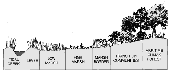
At higher elevations is the marsh border where the tidal flow no longer reaches except during spring tides and storm surges. Without the daily wash of seawater, rains and freshwater runoff greatly lower the salinity of the marsh border. The tall, dark needle rush and the yellow aster flowers of the sea oxeye daisies rim the marshes and hammocks in summer. In the fall a lavender hue is added to the marsh edges with the flowers of marsh lavender and marsh aster.
The marsh ascends into a transition community of shrubs and small trees, i.e. groundsel tree, marsh elder, wax myrtle, cedar, red bay, yaupon holly, woody vines, etc. Notice that many species are the same as those found in the shrub forest of a beach, and in the same way, the transition zone eventually succeeds to a maritime forest.
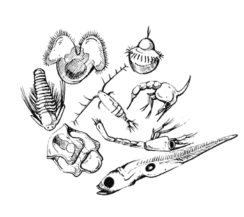
As mentioned early in this section, the rapid changes in temperature and salinity accompanying the tides are very difficult for resident aquatic animal life to adapt to. Experienced aquarium owners know how thermal and osmotic changes bring rapid death and disease to fish. Many of the sessile (attaching), crawling, burrowing, and territorial animals in the tidal rivers and mud flats have evolved an amazing variety of adaptations to cope with the parade of life-threatening changes that accompany the tides. Contrary to the limited diversity of resident life, there is a great variety of aquatic life drifting and swimming with the tidal currents. By moving with the tide water, these "visitors" do not experience the rapid changes in temperature and salinity because they essentially stay with the same water as it moves through the marsh. Many planktonic larval stages of shrimp, crabs, barnacles, clams, bivalves, and a host of immature fish, such as drum, menhaden, bumpers, and mullet, are some of the many animals drifting with the tides.
Algae and smooth cordgrass are the main (photosynthetic) producers of organic matter and oxygen in the southern marshes. In the clearer offshore waters, algae, in the form of diatoms, dinoflagellates, blue-green algae, and other suspended photosynthesizers are the principal producers. These drifting algal forms are collectively known as phytoplankton. As seawater penetrates the sounds and larger tidal creeks, it becomes more turbid with sediment, detritus (organic debris), and suspended life as it mixes with the water of the marshes. In the marsh creeks, the turbidity of the water often filters out sufficient sunlight to prohibit photosynthesis just inches below the water surface. In these areas, the cordgrass accounts for most of the photosynthetic productivity.
Cordgrass, as a living plant, offers little as a food source to the salt marsh community because of its high content of indigestible cellulose. Only a few animals, such as the periwinkle snail, a few plant-eating insects, and the purple square-backed crab are able to digest cordgrass tissue. Smooth cordgrass is even a poor cattle feed. After cordgrass dies, fungi and bacteria break down the cellulose in the plant tissues, liberating organic nutrients to the consumers of the marsh. The fungi and bacteria themselves are an important food source for the filter feeders and tiny animals of the community.
Besides the algae, much of the suspended life (plankton) moving in the tidal waters is composed of fragile microscopic animals called zooplankton. Many zooplanktons are larval stages of every marine phylum, including the commercial species of shrimp, blue crab, and clams. As mentioned earlier, immature stages of the local fish also accompany the tides. Some animals spend their entire life as zooplankton, such as the copepods, which have been called the most common animal on earth and are a vital link in the world's aquatic food chain. The plankton and small swimming life act as a self-sustaining "bouillabaisse" for the larger animals to feed upon. As many of the stronger swimming fish of the marsh grow and mature, they migrate to the offshore waters and become a part of the ocean's food chain. A seine net pulled in a marsh creek reveals a wide variety of smaller fish and invertebrates, many of which are immature. It is clear that the salt marsh plays a major role as a nursery ground and generator of food for the ocean.
 The
scarcity of larger fish in marshes, sounds, and nearshore waters limits the
Georgia fishery to shrimp and blue crabs. A few other species, such as
The
scarcity of larger fish in marshes, sounds, and nearshore waters limits the
Georgia fishery to shrimp and blue crabs. A few other species, such as
whelk (popularly but incorrectly called conch) and shad are harvested for short
periods in the winter. At the turn of the century, oysters were Georgia's largest
fishery, but outbreaks of oyster diseases have all but wiped out the industry.
Quahog clams are plentiful but the labor-intensive method of hand-gathering
the clams has limited this fishery.
Only in the top 100 to 300 feet of ocean is there sufficient sunlight to enable phytoplankton to photosynthesize. The open or pelagic oceans are on the average 2 miles deep. Most of the products of decay, which are the source of the phytoplankton's fertilizers, are located on the bottom. The pelagic phytoplankton populations are kept to a stringent minimum as they have only the trappings of fertilizer left behind as the dead organisms sink into obscurity. Since the planktonic algae are the only producers on which all but the deepest sea life is dependent, sea life as a whole is sparse in the open oceans. In some temperate regions, seasonal temperature changes and wind-driven currents create convection currents that kick up nutrient-rich waters from near the bottom, making these cold, oxygen-rich waters some of the world's greatest fishing grounds.
The shallow seas covering the continental shelves are the most productive environments of the ocean because their bottom is sufficiently close to the sunlit waters to allow the phytoplankton free access to the decomposition products. With unleashed algal growth and photosynthesis, animal life abounds. Salt marshes, kelp forests, and coral reefs are among the most productive of these nearshore environments. Without the contributions from the shallow seas, the ocean would be unable to maintain its present quantity and diversity of life. These vital areas are also the most vulnerable to man's impact. Oil spills, industrial waste, and residential development are escalating and polluting increasingly greater areas of these productive ocean environments every year. Hopefully, humankind will develop more earth-centered attitudes to conserve the quality and diversity of life in the world's oceans and protect our beautiful barrier islands.
Read and add comments about this page
Go back to previous page. Go to Barrier Islands contents page. Go to Sherpa Guides home.
[ Previous Topic | Next Topic ]