[Fig. 7] A developed trail through pine rockland forest in the lower Keys, and a chance to see one of nature's wonders, the tiny Key deer, are the reasons most visitors head for the Key Deer National Wildlife Refuge.
The refuge encompasses about 8,000 acres on Big Pine Key, No Name Key, other
lower Keys, and some smaller outer islands. Many of the parcels on Big Pine
are separated by wide tracts of land in private ownership. The refuge's main
goal is the protection of the endangered Key deer by seeking ways to increase
and stabilize its numbers.
A subspecies of Virginia white-tailed deer, Key deer are the smallest of all white-tailed deer. With a shoulder height between 24-32 inches, Key deer are about the size of a German shepherd. Females weigh 45 to 60 pounds, bucks 55 to 80 pounds.
Key deer mate between September and December. Gestation is 204 days and fawns are about the size of a house cat. Generally born between April and May, they weigh between 2 to 4 pounds. Females reproduce after two years. First-time mothers usually give birth to a single fawn and after that occasionally more than one. Males rarely take part in breeding after their third year. Even under the best of circumstances, males and females rarely live beyond eight years.
The upper part of the deer's body is light reddish brown. The underside is
white, as is the underside of its tail. Faces have a dark, V-shaped marking.
Believed to be originally about the same size as other North American white-tailed deer, the Key deer probably migrated to this area from the Florida mainland tens of thousands of years ago, when what is now Florida Bay and the Keys were dry land. As the earth warmed, seas rose creating Florida Bay and a chain of small islands.
Isolated from the mainland, with limited food sources, smaller deer survived, while the larger deer perished. The deer adapted to their environment and reached their present size about 1,000 years ago. They were an important food source for Indian tribes. European explorers in the sixteenth century found them in large numbers. Hernando d'Escalante Fontaneada, a Spaniard taken prisoner by Calusa Indians in the 1570s, was the first European to call attention to them. He called them "a great wonder" in a diary he kept during 17 years of captivity. Word of the deer reached Caribbean sailors, who hunted them for meat and hides.
As the human population in the Keys increased in the mid-1800s to late-1800s, much of the deer's wooded habitat was cleared for timber and farming. Hunters with dogs often burned thick vegetation to drive the deer from their habitat into the water where they could easily be shot and clubbed.
By the early 1930s, the deer were close to extinction. In 1934, Jay N. "Ding" Darling, a conservationist, cartoonist, and chief of the U.S. Bureau of Biological Survey (which later became the U.S. Fish and Wildlife Service), was horrified by a deer slaughter he witnessed from a fishing boat. His nationally syndicated cartoon, "The Last of the Toy Deer," helped convince the Florida legislature to ban hunting of Key deer in 1939. Nonetheless, with little or no enforcement, the destruction continued unchecked.
By the early 1950s, surveys found the deer population had dwindled to less than 50. In 1957, Congress established the Key Deer National Refuge, and through the zealous efforts of a game warden named Jack Watson the deer began a revival. The deer were further protected under the 1967 Endangered Species Act. By the mid-1970s, their numbers increased to an estimated 300 to 400.
Their numbers declined again over the next two decades. However, in the past five years, their population has risen dramatically, and today there are believed to be between 580 and 680 on Big Pine and No Name keys and less than 100 on smaller islands included in the refuge.
Like many of Florida's other endangered species, the deer's march toward extinction is hastened by a growing human population, which is encroaching on the refuge with subdivisions and other facilities. Collisions with vehicles are also taking a toll. Each year several dozen grazing on roadside grasses wander innocently, and fatally, into harm's way. The number of road kills has been steadily rising since 1995, culminating in 90 in 1998, which is 68 percent of all known deer deaths for that year. Some deer drown while attempting to swim between keys. This frequently occurs during dry seasons when the animals attempt to swim to other islands in search of fresh water. Some Key deer fawns and does fall into mosquito control ditches and drown when water levels rise.
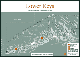
To visit the refuge, turn off US 1 at Key Deer Boulevard (MM 30.5) and look for the U.S. Fish and Wildlife Service Headquarters in the Big Pine Shopping Center on the right. Pick up information on nature trails and areas where you're most likely to see the deer. Like most wildlife, the deer are most easily seen early in the morning and in early evening when they come out of the forests to eat and drink at ponds and water holes.
Take heed of the dos and don'ts. Obey posted speed limits, and carefully watch the roadsides for any deer that might be on the verge of darting into the path of your vehicle. Another important rule is don't feed the deer, either by hand, or by leaving food on the ground for them to find. Deer accustomed to human food are more likely to wander onto highways and onto private property, where they're frequently attacked by dogs while feeding on shrubbery and gardens. Interacting with them also entices them to continue to approach people and roads, where they are more likely to be struck by vehicles.
After leaving the refuge headquarters, turn right and drive 2.25 miles on Key Deer Boulevard to Blue Hole. This former oolitic rock quarry, blasted out during the railroad days and filled with fresh water is the largest body of fresh water, in the Keys, and is a primary place for Key deer to drink.
Deer feed primarily on fruit and leafy plants, including red and black mangrove, Indian mulberry (Morinda royoc), pineland acacia (Acacia farnesiana), thatch palm fruits, blackbead, grasses, pencil flower (Stylocanthes hamata), and wild dilly fruits. At Blue Hole's wooden viewing platform you can observe alligators, turtles, wading birds, and fish, including exotics like koi and goldfish that people have dumped into the lake. A humorous sign by the water hole carries a serious message about the dangers of not respecting alligators:
There once was a gator named Allig,
Who lived in a place called Blue Hole,
Some people fed him, while others they swam,
But most of the water was his dinner bowl,
So, Allig grew braver with each passing week,
And no longer called his visitors sir,
He mistook a young miss for his usual fish,
And one morning before breakfast,
Allig-ate-her.
The Blue Hole observation platform can bring you face-to-face with deer, raccoons, and other creatures. You can also see them in Watson's Hammock, a hardwood hammock off Higgs Lane just beyond Blue Hole. A lofty tree canopy includes a massive gumbo-limbo tree, although this hammock was hit hard in 1998 by Hurricane Georges. From Blue Hole, drive or hike 0.25-mile up the road to the paved parking area at the Jack Watson and Frederick C. Manillo wheelchair accessible nature trails. Check to see if any refuge brochures are in the boxes by the trailheads.
The Jack Watson Trail is a 0.66-mile loop developed in partnership between the U.S. Fish and Wildlife Service and the nonprofit Florida Keys Land Trust. "Watchful Steward of the Key Deer Refuge," Jack Watson was a game management agent for the U.S. Fish and Wildlife Service in the 1940s and 1950s and an early manager of the refuge. He spent nearly 25 years working to protect the deer and is given much of the credit for fostering their step away from extinction.
Pause and read the trail-side markers. Heed the warnings about poisonwood plants. A member of the cashew family, the poison tree grows from shrub size to 30 to 40 feet tall. The slightest touch of the sap from its reddish-brown, scaly bark and shiny green leaves, dotted with black spots, can set off a virulent, itchy rash similar to poison ivy, poison oak, and poison sumac. The tree's fruit is a main food source for white-crowned pigeons.
Although it is rarely seen and not found on the nature trails, be extra cautious
of the manchineel tree (Hippomane mancinella). One of the world's most
poisonous trees, the small trees with oval, sharp-pointed leaves and yellow
and green flowers carry a double whammy. The tree looks similar to guava and
other tropicals, but the plumlike fruit is highly toxic to anyone unfortunate
enough to bite into it. In addition, the manchineel's milky sap burns human
skin like the most caustic battery acid. Calusa Indians used it for torture
and fatally shot sixteenth-century Spanish explorer Juan Ponce de Leon with
an arrow dipped in manchineel sap.
Benign plants include buttonwood trees. Found in the lower areas, where the soil is wetter, the ridged gray-brown buttonwood bark has medicinal properties and is used in tanning hides. A member of the white mangrove family, buttonwood can reach a height of 40 to 50 feet and has a narrow rounded crown, elliptical evergreen leaves, and small, green, oval-shaped flowers. Around the turn of the century the wood was commercially harvested for charcoal.
The pine woodlands are also home to several species of snakes. Among the most venomous are Eastern coral snakes but they are rarely seen. Up to 2 feet in length, with alternating black, red, and orange bands, and a broad yellow band on its head, the coral snake is usually not aggressive, but its bite can be deadly if antivenom is not quickly applied. Keys hospitals are well equipped and staffs are trained to respond quickly to snake bites. Nonvenomous scarlet kingsnakes and scarlet snakes have similar bands and are often mistaken for coral snakes.
The Eastern diamondback rattler has distinctive black diamond patterns, outlined in black and yellow. If you hear its rattle, stand still and allow it to pass you by. Some can grow as long as 6 to 8 feet.
As a general rule, snakes are wary of humans and don't look for trouble. If you stay on the trails and out of the underbrush, you can enjoy your hike free of fear of snakes.
Walk into the Watson Trail's pine rockland forest, a green canopy that grows out of caprock and oolite substrate. In the U.S., pine rocklands are found only in southern Florida, and only 5 percent still survive. Over 80 percent of those are in the National Key Deer Refuge. There's underbrush in the pine rockland, but a look inside a small solution hole reveals native orchids and ferns, tiny fruits and flowers, frogs, insects, snakes, and fish.
Next on the Jack Watson Trail pass through one of the best examples of a tropical hardwood hammock remaining in the Lower Keys. Tropical hardwood hammocks are prevalent here and elsewhere in the Keys and other areas of southern Florida. Hammocks (a variation of hummock) are groves of tropical hardwood trees, shrubs, and plants that grow on ridges and islands of ground elevated above the level of surrounding marshes and other wet areas. From 80 to 100 species can flourish in a single hammock. They include mahogany, gumbo-limbo, pigeon plum, poisonwood, and many types of vines, mosses, and lichens. Hammocks are also habitats for many species of tree snails and butterflies, including the rare Schaus' swallowtail butterfly.
A marker advises us to connect with our surroundings: "You're in the midst of one of the natural habitats of the Keys...Focusing one's senses can create a sense of place. Allow yourself to become part of what you're experiencing. Look up at the tall pines, the color of the tropical sky, the openness of the tree canopy. Look down at the ground, focus on the tiny plants, the spare soil, exposed and abundant rock, small holes filled with water. Look for evidence of fire at the bases of palms and pines and observe the difference in leaves that reveal a great variety of plants.
"Now smell the pine rocklands, the wax myrtle (Myrica cerifera), slash pines, white stopper and possibly the odor of the last fire. Listen to the insects, the call of birds, the rattle of thatched palms, and the intervals of silence..."
Farther on, another marker tells us this: "What you're seeing is essentially what Native Americans would have seen before the rush of civilization. The pine rockland forest contains more than 250 species of plants, but the dominant feature is the slash pine, so-called because they were slashed for turpentine. They're extremely fire resistant, and are so deep rooted even a dead tree can stand for many years. They serve as feeding areas for woodpeckers and roosting places for hawks, ospreys, and turkey vultures."
Another marker points out that fire is a beneficial natural phenomenon that plays a major role in shaping Florida's ecosystems. Pinelands depend on periodic fires, frequently ignited by lightning during summer thunderstorms. Saw palmetto, longleaf (Pinus palustris), and slash pines have developed a resistance to fires. Their outer bark may be burned, but their inner core stays protected. Some may live for several hundred years. Fires clear away low branches and dead and unhealthy trees and enable sunlight to reach the forest floor. Ashes from the trees and grasses and low shrubbery nourish the soil. Pine cone seeds that fall onto this fertile bed quickly germinate.
The Frederick C. Manillo Jr. Nature Trail is a smooth, flat, disabled-accessible 250-yard forest trail that leads to a platform overlooking a small wetland. Markers identify trees and plants. Manillo (1948-1996) was a strong advocate of environmental conservation.
If you fail to happen upon Key deer on the Watson Trail, you may need to go looking for them. The deer are common in some parts of Big Pine, and can often be spotted in the daytime along roadsides and in some of the neighborhoods on Big Pine. One of the best ways to see deer is to drive slowly through the neighborhoods branching off of Watson Boulevard, being careful not to disturb the residents.
A very likely spot is the very end of Key Deer Boulevard (CR 940), which goes north from US 1 at the only traffic light on the island. Follow the road all the way to the end, about 4.5 miles. The road passes a subdivision and dead ends at some land managed by the National Key Deer Refuge.
Park and wait for a few minutes. By looking back down the last 0.5 mile or so of straight road you'll be able to see when a Key deer ventures out on the road shoulder, something they do all the time. Many of the deer have radio tracking collars on as part of a study to determine their numbers and movements.
A few yards past the end of the road, you'll see one of the hundreds of miles of mosquito ditches that were dug into the hard limestone throughout the island. The idea was to drain the land and lower the population of saltwater mosquitoes. Only about a foot wide and a couple feet deep, the ditches unfortunately became death traps for Key deer fawns and even adults who couldn't climb back up the steep sides.
Although the residents of the nearby subdivision aren't necessarily fond of a constant flow of tourist traffic winding up and down their streets, the deer do hang around in their yards, in part because of a now limited practice of people feeding them everything from heads of lettuce to table scraps.
Another reliable deer sighting spot is on No Name Key. Head back down Key Deer Boulevard and turn left (east) on Watson Boulevard. Turn left at the stop sign on Avenue B, cross a small bridge, and continue through the subdivision. The road crosses another longer bridge onto No Name Key.
Key deer are commonly seen along this road. Follow it to the end where you can walk out for a look at the Gulf of Mexico waters. Keys residents once regularly fed the deer at this spot, and many deer still come around. Unfortunately, it's also an area that collects a lot of trash and garbage. It's important to resist the urge to feed the small deer. It only hurts their chances for survival.
Diving in the Lower Keys consists of an outstanding array of possibilities enhanced by reliable water clarity and warm weather. Dive shops cater to a variety of experience and offer a wide choice of dive trips including custom trips and night dives.
By far the most popular dive spots are in the Looe Key Marine Sanctuary. Hundreds of other dive spots from patch reefs very close to shore to ledges in 90 feet of water are waiting to be explored.
The Gulf of Mexico side of the islands has its own interesting diving sites. The Rock Pile north of Content Keys is a unique site in 15 to 20 feet of water that displays hundreds of attractive coral heads. Ledges of coquina rock only 50 yards off some of the islands are worth seeing.
A serious amount of damage at popular reef diving sites is caused by boat anchors striking the fragile coral, or the rope or chain attached to the anchor chafing coral or breaking off coral branches. A mooring buoy system has been developed to reduce anchor damage and to provide convenient means for securing boats.
At many reefs, mooring buoys encircle the shallowest reef areas or are located on the ocean side of the reef. Shallow reef areas are distinguished by brownish-colored water. Circle around either side of these shallow areas—always steering to the outside of a ring of buoys—and never motor directly across a shallow reef to get to a buoy!
Following are basic steps for using mooring buoys provided by the Florida Keys National Marine Sanctuary.
[Fig. 7(1)] A spectacular coral reef track, 5 nautical miles offshore from Ramrod Key, the 5.3-square mile sanctuary is a sub-unit of the Florida Keys National Marine Sanctuary. It gets its name from the British frigate HMS Looe that sank there in 1744. Ballast stones from the ship can still be seen at the reef.
Although small compared to other Keys reefs, many seasoned divers give Looe Key top ranking. The wish-bone-shaped diving area, about 200 yards wide and 800 yards long, descends through gin-clear waters some 35 feet down to a sand bottom. Snorkelers and scuba divers alike float through caves and canyons, surrounded by countless and colorful varieties of fish, lobsters, and stingrays that swim among the brain coral, pillar coral, soft coral, sea fans, and sea whips.
Only 5 nautical miles from shore the reef is a good choice for those not-too-experienced divers that want to captain their own snorkeling trip to a reef. Boats and snorkeling equipment can be rented on Big Pine and Little Torch Key.
The trip begins with a few simple directions on following a marked channel to the Atlantic Ocean. From there it's a straight shot out to the reef. Mooring buoys are provided to avoid damage to the reef from anchoring.
Once safely tied off you're ready to slip over the side into a world that nearly defies description. The reef's majestic ledges of living corals on the fore (the side facing the ocean) stand upon 7,000 years of coral growth. A classic spur and groove formation, it sports fingerlike spurs of coral separated by grooves of sand and rubble.
Every July the Lower Keys Chamber of Commerce holds an annual Underwater Music Festival at Looe Key. Microphones are dropped onto the water, and divers can explore the reef to the sounds of rock and roll.
If you rent a boat, before leaving the dock discuss weather and sea conditions with the marina personnel and be sure to have a complete understanding of the boat's operation and safety equipment. Although close to shore, Looe Key is still in the open sea, which can become very rough under certain wind conditions.
Fishing is hugely popular in the Lower Keys as it is throughout the chain of islands. Charter boats and fishing guides stand ready to fulfill your fishing dreams, whether that entails fighting a leaping sailfish, making the perfect cast to a large bonefish, or struggling to pull a grouper from the bottom.
In summer, offshore action on the Atlantic side of the Lower Keys is largely focused on dolphin. Also known as dorado or mahimahi, these blue, green, and yellow fish put up a great fight, and are excellent table fare.
With the arrival of the first cold fronts come the first sailfish of the year. Unlike the catch and kill approach to trophy billfishing in the past, most sport-fish enthusiasts release the sailfish they catch and have a plastic replica created to commemorate their catch. Trolling the deep offshore waters also means a chance to catch blue and white marlin, wahoo, king mackerel, blackfin tuna, and barracuda.
Inshore reef fishing means targeting large groupers and a variety of snapper including lane, gray, and yellowtail. Other species commonly caught over the reefs are king mackerel, jacks, cobia, and barracuda. Some of the best fishing takes place in 60 to 100 feet of water.
The channels between the keys offer excellent fishing for grouper, snapper, and jacks. In the spring, lots of effort turns toward the almighty tarpon. Giant silver kings, up to 200 pounds, settle in for a few months of feeding in the churning waters caused by tidal currents flowing through the bridge pilings in the passes.
Tarpon also hang out on the wide sandy flats along both the Atlantic and Gulf of Mexico sides. The other flats inhabitants, permit and bonefish, have become the popular targets of fly-fishermen and other shallow water, light-tackle advocates.
In the Gulf of Mexico, fishing centers around reef and wreck fishing. The goal is to locate structure on an otherwise smooth bottom. That's where grouper, snapper, permit, cobia and shark will be waiting.