[Fig. 23(3)] Like so much of the land on both sides of Virginias Eastern Shore, most of the 5,574 acres of Saxis Wildlife Management Area are comprised of tidal marshes. There was a day when such marshes were considered useless areas of muck and mud full of strange amphibians and reptiles, not to mention the hoards of biting insects.
Today, however, with public appreciation growing for the value of wetlands, the Virginia Department of Game and Inland Fisheries oversees the use of the Saxis area for both recreation (hunting, fishing, and bird-watching) and the protection of the habitat. The marsh is divided into two portions that take up most of two peninsulas on the bay side of Virginias upper Eastern Shore.
Michael Marsh is the southernmost tract, and is closed to hunting. The Saxis area on the northernmost peninsula is located about 1 mile south of the Maryland border and is a prime breeding and wintering ground for the black duck (Anas rubripes). Mallards, blue-winged teal, green-winged teal, and pintails are some of the puddle ducks that are found on the lakes and creeks. The open water attracts mergansers, redheads, goldeneyes, and canvasbacks. Grebes, loons, and a multitude of shorebirds and songbirds make Saxis an excellent place to add another bird or two to a life list.
Hunters come to Saxis not only for the excellent waterfowl hunting but also for white-tailed deer that slip through the forests on the higher ground. In addition to the usual raccoons, muskrats, opossums, and rabbits of the Eastern Shore habitat, Saxis contains red and gray foxes and river otters. At dusk, car lights may even pick up the yellowish-green glow of two mink eyes.
The mink (Mustela vison) has everything it needs here. Fish are a favorite food, as are birds and their eggs. Soft mud banks above the high tide, or even a muskrat hole will do fine for a den. And if disturbed, the mink has a little-known weapon. It can emit a foul odorperhaps not so strong as a skunks, but disagreeable enough to do the job.
Striped bass (rockfish), flounder, gray trout, speckled trout, croaker, and bluefish benefit from the nutrients and prey that are in rich supply around such undisturbed marshes. Anglers, in turn, cast to the grasses and the points, or come up into Messongo Creek and Pocomoke Sound to find the fish. Boats may be launched at Saxis, Messongo Creek, and Marsh Market. Contact the fish and game department for a detailed map.
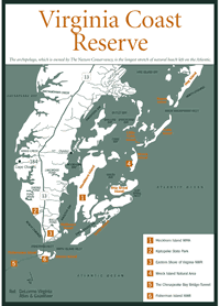
[Fig. 24(1)] The 7,000 acres of tidal marshes that make up Mockhorn Island are perfect habitat for the clapper rail (Rallus longirostris), known more for its loud clattering call across the saltmarsh cordgrass than for its mottled brown appearance. The best time to catch a glimpse of the secretive bird is at high tide, when rising water may force it into the open. The wildlife management area itself, on the other hand, nearly disappears: Just 5 percent of it remains above the water at high tide.
The island, managed by the Virginia Department of Game and Inland Fisheries, attracts rail and waterfowl hunters from the nearby boat ramp at Oyster. Black ducks spend the winter at Mockhorn. Occasional bird watchers study ducks such as buffleheads, goldeneyes, and Atlantic brant. Sea ducks such as oldsquaws and scoters bob on the open water around the island.
Anglers know the area for saltwater species such as flounder, croaker, and gray trout. Monstrous red drum (channel bass) and black drum will tire even the strongest fisherman when they start hitting bait in early summer.
On the hummocks of marshland, muskrat chew on grasses and raccoons open crustaceans, leaving little piles of shells beside their tiny handlike paw prints in the mud. River otters may emerge from the water onto shore, only to make a C turn and torpedo back into the water.
In addition to the cordgrass of the marshes, a coastal forest of loblolly pine, red cedar, and wax myrtle covers the higher ground. Herons and egrets, looking gangly in their nests of sticks in the low shrubs, are transformed into pure artistry in flight.
A second, much smaller portion of the area is the 356-acre GATR Tract on the mainland adjacent to the islands southern tip. Besides the fishing here, the game department offers an archery season for deer in the fall. A small trail system begins at the gated road at the parking lot. The game and fish department can supply a map showing both tracts in detail.
[Fig. 24] When some developers look at what seems to be marshy, vacant coastal islands, they may envision gleaming resort cities, with rows of hotels, swimming pools, and parking garages. Sometimes, though, there are people with other ideaspeople who not only see the value and beauty of tidal marshes, but also people with the financial and legal clout to step in and offer protection.
Were it not for the second kind of visionaries, Virginiansand all Americansmight have lost a natural treasure on the Eastern Shore. All or part of 14 barrier islands encompassing 45,000 acres between the Virginia/Maryland border of the Eastern Shore and the mouth of the Chesapeake Bay make up the Virginia Coast Reserve. Some of the larger islands (from north to south) are Metomkin, Cedar, Parramore, Hog, Cobb, and Smith. The archipelago, which is owned by The Nature Conservancy, is the longest stretch of natural beach left on the Atlantic Coast. According to the Conservancy, it represents the best example of the barrier island community in the country. Combined with Assateague Island National Seashore and Chincoteague National Wildlife Refuge on the northern end and Eastern Shore of Virginia and Fisherman Island national wildlife refuges on the southern end, in addition to holdings of the Virginia Department of Natural Resources, the stretch of islands forms an impressive refuge for plants and animals.
Even here, along this segmented expanse of now-deserted windswept islands, there were once resorts and sportsmens hotels (Cobb Island), and a village of 250 people (Hog Island). Pirates have hidden in the sloughs, musket fire of Revolutionary War battles has startled clamoring geese and ducks into the air, ships have wrecked on offshore reefs, and colonists have turned hogs and cattle loose to graze.
As The Nature Conservancy has bought the islands, silence has once again settled like evening mist over the grasslands. Over the years, biologists have come to realize the importance of the saltmarsh cordgrass (Spartina alterniflora) marshes on the backside of the islands to the health of the Chesapeake Bay. An incredible 90 percent of the shellfishthe crabs, clams, oysters, and suchthat are harvested in the bay are dependent on the marshes for at least some of their lives. Nutrients filter through the marsh soil and grasses and are released slowly into the water.
In addition, many plants and animals depend on the islands. Upland pine and hardwood forests spread across the larger islands. The inland reaches of these larger islands supports brackish and even freshwater marshes.
Perhaps the best known resident of the reserve is the rare piping plover (Charadrius melodus). Because the plover nests in a depression on the sand, it is very vulnerable to predators. Its numbers have gone into serious decline in recent years due to loss of habitat to development, a fact that has gotten this little bird a great deal of news coverage in recent years as naturalists scramble to arrange for its protection. Of course, anything that benefits the plover also benefits other birds. Besides thousands of nesting birds, a vast number of migratory shorebirds and wintering waterfowl use the wide expanses of marshes and mud flats.
Because of its pristine nature, the United Nations has designated the Virginia Coast Reserve a World Biosphere Reserve and the U.S. Department of the Interior has listed it as a National Natural Landmark.
The old U.S. Coast Guard Station on Parramore Island was in the process of being renovated to serve as a center for educational programs until it was destroyed by fire in 1999. The Nature Conservancy is planning a new structure to take its place. Boaters may visit the islands for low impact day use such as bird-watching and beachcombing. However, with tidal marshes on the western or shore sides of the islands, ocean waves on the eastern sides, and dangerous currents in the inlets, access may be tricky at times. Perhaps the best way to see the islands is to contact headquarters to find when educational tours are scheduled. No fires, no overnight camping, and no pets are allowed on the islands. Boaters should not come ashore where there are nesting colonies of birds.
[Fig. 24(2)] The name Kiptopekepronounced KIP-toe-peekis an Indian name meaning "big water" and has an interesting origin. When Captain John Smith left Jamestown to explore the Chesapeake Bay in 1608, he met the king of the Accawmack Indians and his friendly younger brother, Kiptopeke. The site of the former ferry terminus at the park was named Kiptopeke Beach in honor of this friendly Indian.
Kiptopeke State Park is called a work in progress. Each year, repeat visitors find new Facilitieshookups for the campgrounds, improved bathhouses, a new boat ramp, new landscaping, and so on. But one of the best things people find if they happen to arrive in fall is one of the premier bird-banding operations of its kind on the East Coast.
Since 1963, the Kiptopeke area has been the hub of activity for the Virginia Society of Ornithology, a group of enthusiasts who keep tabs on bird populations. Volunteers have banded over a quarter of a million birds. Together with the Hawk Migration Society, they have also recorded more than 400,000 hawks and other birds of prey since 1977.
The site is a natural for the study. The Eastern Shore peninsula narrows from north to south like a huge finger, literally pointing the way for birds on their southward migration. Birds instinctively stay over land as long as possible, so the peninsulas configuration funnels them in huge numbers to the small southern tip.
Visitors at the park are treated to demonstrations of the banding process during the Eastern Shore Birding Festival (757-787-2460). Warblers, titmice, sparrows, and other birds are plucked gently from mist nets that snag them as they flit through the understory. They are then processed, which includes weighing them, determining their fat content visually by blowing gently to part their breast feathers, placing a lightweight band on one leg, and releasing them to continue their flight.
The festival is held every weekend following the first Wednesday in October. In addition, on Saturday mornings from September 15 to November 15, park interpreters lead tours of the bird-banding station and visits to the hawk observatory. Canoe tours to nearby conservation areas and walks at Fisherman Island National Wildlife Refuge are also part of the fall interpretive program.
Another interesting feature of Kiptopeke State Park is the row of nine sunken concrete ships from World War II that forms a breakwater and artificial fishing reef about 1,500 feet offshore. In 1998 the park system opened a new boat ramp that can handle two cars at a time. The extremely popular landing gives boaters access not only to the concrete ships but also to the productive rock islands of the Chesapeake Bay Bridge-Tunnel, Fisherman Island, the seaside barrier islands, and the Atlantic Ocean.
Anglers fishing from the park shore reel in nice-sized speckled trout. Specks, as theyre called for short, along with striped bass (rockfish), perch, spot, gray trout, flounder, tautog, and crappie also hit bait cast from the 1,000-foot-long lighted fishing pier, which has been converted for use from the old ferry terminal.
Lifeguards are stationed at the approximately 0.5-mile northern beach from Memorial Day through Labor Day. The beach is connected to the picnic area by a boardwalk across the dunes. The full-service wooded campgrounds have sites with or without hookups, in addition to restrooms and warm showers.
Hikers can cool off in the shade of a hardwood forest along the 1.5-mile Baywoods Trail, where white-tailed deer, red and gray foxes, and raccoons live. Bicycling is restricted to park roads only. Leashed pets are allowed.
[Fig. 24(3), 24(6)] Two adjacent national wildlife refugesEastern Shore of Virginia and Fisherman Islandare valuable especially for the large number of birds that funnel through here on their southward migration.
The Eastern Shore of Virginia refuge lies along both sides of US 13 at the southern tip of Northampton County. The refuge was established in 1984 to provide habitat for migratory and endangered species on the 725 acres of wildlife habitat. Consequently, visitors who walk the maritime forests, grasslands, and the thickets of wax myrtle (Myrica cerifera) and bayberry (Myrica pensylvanica) may be lucky enough to spot one of the bald eagles (Haliaeetus leucocephalus) or peregrine falcons (Falco peregrinus) the refuge is designed to protect.
More likely, they will catch glimpses of migrating warblers and songbirds in the undergrowth or see a northern harrier (Circus cyaneus) in flight over the marsh. Kestrels (Falco sparverius), also known as sparrow hawks, perch on power lines. Bobwhite quail (Colinus virginianus) call on spring evenings from the fields. Eastern bluebirds (Sialia sialis) flutter to the ground to pick up insects.
Ponds have been created to attract ducks and other waterfowl of freshwater wetlands, while the mud flats and salt marshes provide habitat for shorebirds and shallow waders such as the glossy ibis (Plegadis falcinellus), cattle egret (Bubulcus ibis), and willet (Catoptrophorus semipalmatus). The variety of habitats and birds that use them make the Eastern Shore of Virginia National Wildlife Refuge an important part of the bird banding and bird counts that take place at nearby Kiptopeke State Park.
The visitor center is on VA 600, about 0.25 mile north of the bridge-tunnel tollgate. Down the road, a 0.5-mile interpretive trail loops through a stand of hardwoods, past an old graveyard, and up a mound to a World War II bunker where there is a sweeping view across the low marshes and barrier islands to the Atlantic.
The past military use of the area is understandable because of the strategic location of the refuge at the mouth of the Chesapeake Bay. Fort John Custis was built here at the beginning of World War II, with 16-inch guns mounted in the bunkers as protection for naval bases and shipyards at Virginia Beach and Norfolk.
If time allows, instead of driving on refuge roads to the interpretive trail and overlook, take the 0.5-mile Butterfly Trail that leads southeast from the center to the interpretive trail. In addition to many varieties of butterflies drawn to the flowering shrubs and wildflowers, hikers could startle a woodcock (Philohela minor) into sudden flight. Refuge naturalists say the site has a higher population of this woodland worm-eater than any other place in the United States.
Fishermans Island National Wildlife Refuge off the southern tip of the Eastern Shore is aptly named. Its waters are a popular place for anglers. Positioned at the mouth of the Chesapeake Bay, the wetlands around the island are frequented by many species of fish that migrate seasonally into and out of the estuary. In late spring and summer, the tidal marshes and inlets hold flounder, spot, croaker, gray trout, rockfish, and bluefish.
Also, the island is the last stop before the bay crossing for birds that migrate down the Eastern Shore peninsula on their way south. Bird banders keep meticulous records of both migrating birds and the diverse nesting colonies of terns, gulls, herons, and ibis. To take a guided 4-mile hike on the island, join a scheduled hike from the Eastern Shore of Virginia refuge. Access is by permission only and the island is closed during late spring and early summer while royal terns (Thalasseus maximus), ring-billed gulls (Larus delawarensis), and shorebirds nest on the beaches.
[Fig. 24(5)] The worlds largest bridge-tunnel complex is the 17.6-mile span across the mouth of the Chesapeake Bay. The Chesapeake Bay Bridge-Tunnel opened to traffic in 1964, ending an old ferry service and dramatically upgrading the connection between residents of the Eastern Shore of Virginia with the mainland. On a drive from Virginia Beach to New York, the crossing on US 13 saves travelers 1.5 hours of driving time and cuts 95 miles off their trip.
The highway connects Virginia Beach and Norfolk on the south side with the southern tip of the Eastern Shore of Virginia to the north. Travelers drive to breathtaking heights on high trestles above the water. Twice they come down into mile-long tunnels, while military ships from the Norfolk Naval Base and giant ocean tankers from distant world ports pass overhead.
The bridge-tunnel is officially named the Lucius J. Kellam Jr. Bridge-Tunnel after the man who had the foresight and vision to make the dream a reality. In 1965, competing with more than 100 other major feats, the Chesapeake Bay Bridge-Tunnel was named one of the Seven Engineering Wonders of the Modern World.
In 1998, a new parallel span of bridge opened and the old one was closed for rehabilitation. In April 1999, the spruced-up old span reopened. Costing nearly $200 million, the construction of the new span and renovation of the old turned the two-lane highway into four. No longer does an entire line of motorists have to wait for a slow vehicle, or do motorists need to take unnecessary risks by passing on the bridge. New tunnels will be built later.
Fishermen bobbing in the water far below the highway see the bridge-tunnel not for its value to get from one place to another, but as the worlds largest artificial reef. The rock islands and the pilings have proven to be fantastic fish attractants. Some of the Chesapeake Bays best catches of bluefish, rockfish, flounder, gray trout, tautog, and cobia come from the bridge-tunnel complex. The 625-foot Seagull Pier is midway across the bridge on a rock island behind the Seagull Pier Restaurant. No fishing license is needed to fish from the pier.
The Chincoteague area has the lions share of restaurants on Virginias Eastern Shore, but there are plenty of other choices sprinkled down the two counties.
AJs. Maddox Boulevard, Chincoteague. Seafood, pasta, aged beef, veal, and lamb are on the menu at this casual restaurant. Moderate. Phone (757) 336-5888.
Chincoteague Inn. Maddox Boulevard, Chincoteague. Enjoy seafood and pasta at a family restaurant. Moderate. Phone (757) 336-5040.
Wrights Seafood Restaurant and Crab Galley. Watts Bay, Atlantic. Features all-you-can-eat dinners in a casual atmosphere. Situated near NASA, about 15 minutes from Chincoteague. Ask about the former poultry processing plant and button factory on the site. Overlooks the bay. Moderate. Phone (757) 824-4012.
Island House Restaurant. 15 Atlantic Avenue, Wachapreague. A popular place for local people and boaters to find the catch of the day. Moderate. Phone (757) 787-4242.
The Trawler Restaurant and Dinner Theater. US 13, Exmore. Eat fresh seafood or steaks, followed by a play. Located just south of the Northampton/Accomack county line. Moderate. Phone (757) 442-2092.
Sting-Rays. 26507 Langford Highway, Cape Charles. Award-winning chili, fresh local seafood, charbroiled steaks. Located on US 13 about 6 miles north of the southern tip of Northampton County. Inexpensive to moderate. Phone (757) 331-2505.
For a home away from home on the Eastern Shore of Virginia, choose anything from an inexpensive motel to a luxurious bed and breakfast inn.
1848 Island Manor House. 4160 Main Street, Chincoteague. Federal-style home is a historic island landmark, furnished with antiques. Rose garden, brick courtyard, fountain. Moderate to expensive. Phone (757) 336-5436 or (800) 852-1505. E-mail [email protected]. Web site www.chincoteague.com/b-b/imh.html.
Refuge Motor Inn. 7058 Maddox Boulevard, Chincoteague. This inn is within walking distance of Chincoteague National Wildlife Refuge and has spacious luxury suites, rental bikes, wooded picnic areas, an indoor/outdoor heated pool, and a playground. Moderate to expensive. Phone (757) 336-5511 or (800) 544-3469, extension 2.
Sea Shell Motel. 3720 Willow Street, Chincoteague. Choose from motel rooms, apartments, and completely furnished cottages. Pool, shaded porches, and shaded play area with picnic tables and grills. Inexpensive to moderate. Phone (757) 336-6589.
Waterside Motor Inn. 3761 South Main Street, Chincoteague. Luxury accommodations, 220-foot private pier, waterfront pool, spa. Moderate to expensive. Phone (757) 336-3434.
Colonial Manor Inn. 84 Market Street, Onancock. Stroll the well-kept grounds or spend an evening in the candle-lit gazebo at this Victorian inn, circa 1882. Shops, restaurants, and theaters are within walking distance. Bikes available. Moderate. Phone (757) 787-3521.
Wachapreague Motel and Marina. 17 Atlantic Avenue, Wachapreague. New marina with boat slips, bait and tackle shop, charter boats, a boat ramp, and small boat rentals. Moderate. Phone (757) 787-2105.
Cape Charles House. 645 Tazewell Avenue, Cape Charles. This bed and breakfast is in a restored Colonial Revival home, furnished with antiques and collections. Moderate to expensive. Phone (757) 331-4920. E-mail [email protected]. Web site www.capecharleshouse.com.
Sunset Beach Inn. US 13, Cape Charles. Located just north of the bay bridge-tunnel, this inn lays out the welcome mat for participants in the Eastern Shore Birding Festival in September and October. It has a bayside beach, pool, restaurant, lounge, boat ramp, and RV campground. Moderate. Phone (800) 4-SUN or (757) 331-4786.
Read and add comments about this page