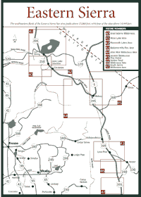
The stark, high desert of the Eastern Sierra contains perhaps as many natural wonders as any other region in California. The steep, sometimes barren eastern slope is almost completely within the Inyo National Forest, a 1.9 million-acre expanse where visitors can find the highest peak in the continental United States and the oldest living things on earth.
 The
forest covers a 165-mile area beginning in the north at Mono Lake, an almost
barren Ice Age relic distinguished by its eerie tufa formations—chemical
sedimentary rocks composed of calcium carbonate or silica deposited from
the water draining into the lake. Around Mono Lake are cinder cones from
volcanoes that have been active in the past 5,000 years.
The
forest covers a 165-mile area beginning in the north at Mono Lake, an almost
barren Ice Age relic distinguished by its eerie tufa formations—chemical
sedimentary rocks composed of calcium carbonate or silica deposited from
the water draining into the lake. Around Mono Lake are cinder cones from
volcanoes that have been active in the past 5,000 years.
On the ground around Mono Lake and in other places, visitors can find pumice, a spongy or porous form of volcanic glass. The extensive volcanic past is still alive and well today as magmatic activity produces clusters of small earthquakes on the Eastern Sierra.
In the Owens Valley, which is between the Sierra and the White Mountains, visitors can see parts of a volcanic caldera, or massive crater, more than 19 miles long and 10 miles wide. The caldera is so large that it cannot be viewed from ground level, but people can look at a map and guide themselves to part of the circular ridge. An enormous volcanic blast created the caldera—known as Long Valley Caldera—about 730,000 years ago. Ash from the blast has been discovered as far away as Nebraska.
To the west of the Owens Valley, the Sierra rises with Mount Whitney soaring to 14,497 feet, making it the tallest mountain in the lower 48 states. Whitney's popularity and size are so enormous that both the U.S. Forest Service and the National Park Service have a part of the mountain in their administrative territories. The majority of the mountain's management is done from the Inyo forest, but Whitney is also a part of Sequoia National Park. And the mountain can be approached from trails that begin or pass through Kings Canyon National Park. Like the Pacific Crest Trail and the Tahoe-Yosemite Trail, Whitney is considered a feature that transcends boundaries in the Sierra.
The spectacular Devils Postpile National Monument is also in the western Inyo National Forest area, though it is managed by the combined Sequoia-Kings Canyon National Parks administration on the west side of the Sierra. The linear basalt formation was created more than 100,000 years ago. Nearby, Mammoth Lakes is where millions of skiers hit the slopes at one of the highest-elevation ski resorts anywhere.
In the eastern Inyo National Forest is a separate range called the White Mountains where the bristlecone pine (Pinus longaeva) is found. Though it is not part of the Sierra, the range is well worth a side trip. The bristlecone pine is considered the oldest living tree, with a life-span stretching beyond 4,000 years. Scientists believe 17 of these trees have lived for more than 4,000 years.
The southern part of the Inyo National Forest contains 12,123-foot Olancha Peak. Olancha is the most southern of the Sierra's great peaks—mountains that are taller than 10,000 feet. The southeastern flank of the Sierra has nine peaks above 13,000 feet. Four of those nine are above 14,000 feet.
Why are the Sierra's tallest mountains on the southeast side? Dramatic faulting along the Sierra crest about 5 million years ago caused the mountain range to lift on the Eastern Sierra. Three distinct pulses lifted the area thousands of feet and created sheer canyons and high ridgelines that run from the crest to the Owens Valley in 10 or 12 miles. The west side is tilted in a long, gentle slope for about 50 miles from the crest.
The differences in the east and west inclines helps to explain why the climates vary so much on either side of the crest. The west slope is much wetter in winter, because Pacific storm clouds drop their moisture as they slowly rise above the mountain range. Near the crest on the Eastern Sierra, heavy snowfall can occur in places such as Mammoth Lakes, where it isn't unusual to receive 75 feet of snow in a winter. But, once the storms clear the crest, they can simply drop down the sheer eastern slope without losing any more moisture. The Eastern Sierra is left quite arid with smaller streams and sparse underbrush compared to the west slope.
The Inyo forest has 519 glacial lakes, and the southernmost of these lakes border the Golden Trout and John Muir wildernesses. They include popular Cottonwood Lakes, Consultation Lake, Meysan Lake, Lake Helen of Troy, and those within the dramatic Palisades Basin out of Big Pine. The Muir Wilderness alone has more than 27 major trailheads, and it is a favorite among backpackers and hikers because of the vast, steep canyons and the soaring granite spires. According to many backpackers and hikers, the striking views are comparable to those in Yosemite National Park, but the trailheads are nearly as crowded.
The only way that many people can see the wonders of the high Sierra is by riding on the back of a pack animal. The Eastern Sierra has many professional packers who guide trips into the high Sierra on the Inyo National Forest and also in Yosemite National Park. Appendix A lists commercial packers who rent animals and provide guides for trips into the wilderness.
The steep Eastern Sierra slope also gives hikers an extraordinary variety of vegetation and animal life to view. Abrupt changes from alpine vegetation to desert sagebrush occur within a few miles. A black-tailed jackrabbit (Lepus californicus) lives in the desert just a few miles from the white-tailed rabbit (Lepus townsendi), which is known to roam higher elevations all the way up to 12,000 feet.
The Jeffrey pine (Pinus jeffreyi) forest along with the lodgepole pine (Pinus murrayana) and red fir (Abies magnifica) forest on the Eastern Sierra support many kinds of mammals, including the least chipmunk (Eutamias minimus), Belding ground squirrel (Spermophiles beldingi), Shasta beaver (Castor canadensis shasta), and mule deer (Odocoileus hemionus).
The bighorn or mountain sheep (Ovis canadensis) has attracted the most concern of any mammal on the Eastern Sierra because its numbers are dwindling quickly. The sheep has been added to the federal Endangered Species Act list and is considered near extinction because of predation from mountain lions (Felis concolor) and disease.
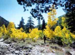
More than 1,000 flowering plants have been collected on the Eastern Sierra. Visitors can find thistle poppy (Argemone munita ssp. rotundata), cow parsnip (Heracleum lanatum), evening primrose (Oenothera hookeri), and scarlet penstemon (Penstemon bridegesii). Like those in the rest of the Sierra, the wildflowers in this area blossom first in the lower elevations and later in summer at higher elevations.
Native Americans made use of many plants. The Paiute, who inhabited the Eastern Sierra for at least the last 1,000 years, figured a way to irrigate taboose (Cyperus esculentus), a plant that has an edible tuber. They also were known to eat pinion pine (Pinus monophylla) nuts through the long winter.
But the Paiute and the Shoshone engaged in wars to stop European settlers from taking the land in the early 1860s. But military action stopped the Native American uprisings in the 1870s, and the Eastern Sierra economy began to grow from mining, grazing, and farming.
Mining took place in the White Mountains and in the Sierra—both sides of the Owens Valley. Miners flooded into such places as Cerro Gordo, Bodie, Mammoth City, and Lundy. By the early twentieth century, with resources dwindling and finances waning, most mining had ended in the Eastern Sierra. Many towns were left deserted. Bodie, in the White Mountains northeast of Mono Lake, is one of the more popular ghost towns for visitors.
Down in the Owens Valley, a notorious water war took place in the early twentieth century. The city of Los Angeles used political influence to bring Owens River water 200 miles south to burgeoning Southern California communities. Owens Valley farmers fought and lost the battle to keep the river. Soon Owens Lake was dried up. The film China Town was based on the Owens Valley dispute with Los Angeles.
After decades of bickering and rancorous debate, Inyo County filed a lawsuit in the 1980s. The county and the city of Los Angeles came to an out-of-court settlement in 1991, stopping Southern California from taking any more water. Streams throughout the Eastern Sierra are regenerating ecosystems that were lost when they were drained.
Mono Lake, which had dropped 45 vertical feet by the mid-1980s and suffered from high salinity, is rising. The tributaries in the Mono Basin had been the target of a second big push for water acquisition by Los Angeles in the 1960s. Environmentalists and scientists later played a role in raising public awareness of the problems. In 1987, the National Academy of Sciences predicted the ecosystem would collapse if water diversions had not stopped.
Read and add comments about this page